Bridge Statistics for Westport, Connecticut (CT)
Condition, Traffic, Stress, Structural Evaluation, Project Costs
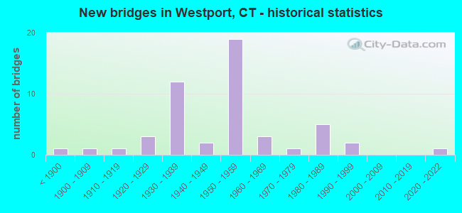
- New bridges - historical statistics
- 1Before 1900
- 11900-1909
- 11910-1919
- 31920-1929
- 121930-1939
- 21940-1949
- 191950-1959
- 31960-1969
- 11970-1979
- 51980-1989
- 21990-1999
- 12020-2022

- Reconstructed bridges - Historical Statistics
- 81980-1989
- 91990-1999
- 22000-2009


- Bridge Condition - Deck
- 44.8%Good
- 37.9%Satisfactory
- 13.8%Fair
- 3.4%Poor

- Bridge Condition - Superstructure
- 3.2%Very good
- 25.8%Good
- 29.0%Satisfactory
- 29.0%Fair
- 6.5%Poor
- 6.5%Serious

- Bridge Condition - Substructure
- 29.0%Good
- 51.6%Satisfactory
- 12.9%Fair
- 3.2%Poor
- 3.2%Serious

- Bridge Condition - Channel
- 4.5%Very good
- 22.7%Good
- 50.0%Satisfactory
- 22.7%Fair

- Bridge Condition - Culverts
- 16.7%Good
- 33.3%Satisfactory
- 50.0%Fair
Find on map >> Show street view
Structure Number: 69, Location: 2.7 MILE NORTH OF RTE 136 (Lat: 41.121150, Lng: -73.320275), Route carried "under" structure: Interstate 95, Year Built: 2021, Structure Length: 0. m, Average Daily Traffic: 110,400 (year 2020), Truck Traffic: 9%, Features Intersected: INTERSTATE-95, Facility Carried by Structure: BEACHSIDE AVENUE
Minimum Vertical Clearance: 5.18m (16.99ft), Kilometerpoint: 33.764, Lanes on structure: 2, Lanes under structure: 6, Material/Design: Steel, Design/Construction: Stringer/Multi-beam, Length of Maximum Span: 32.6m (107.0ft)
Find on map >> Show street view
Structure Number: 72, Location: 1.5 MILE NORTH OF SSR 476 (Lat: 41.126678, Lng: -73.303503), Route carried "under" structure: Interstate 95, Year Built: 1958, Structure Length: 0. m, Average Daily Traffic: 120,000 (year 2017), Truck Traffic: 9%, Features Intersected: INTERSTATE 95, Facility Carried by Structure: SASCO CREEK ROAD
Minimum Vertical Clearance: 4.72m (15.49ft), Kilometerpoint: 35.309, Lanes on structure: 2, Lanes under structure: 6, Material/Design: Steel, Design/Construction: Stringer/Multi-beam, Length of Maximum Span: 30.2m (99.1ft)
Find on map >> Show street view
Structure Number: 726, Location: 0.4 MI S OF ROUTE 33 (Lat: 41.163361, Lng: -73.383486), Route carried "under" structure: State highway 15, Year Built: 1939, Structure Length: 0. m, Average Daily Traffic: 63,100 (year 2015), Truck Traffic: 1%, Features Intersected: ROUTE 15, Facility Carried by Structure: NEWTOWN TURNPIKE
Minimum Vertical Clearance: 4.52m (14.83ft), Kilometerpoint: 32.573, Lanes on structure: 2, Lanes under structure: 4, Material/Design: Concrete, Design/Construction: Arch - Deck, Length of Maximum Span: 13.9m (45.6ft)
Find on map >> Show street view
Structure Number: 729, Location: RT 15 BETWEEN EXITS 41&42 (Lat: 41.163364, Lng: -73.363297), Route carried "under" structure: State highway 15, Year Built: 1940, Structure Length: 0. m, Average Daily Traffic: 72,700 (year 2015), Truck Traffic: 1%, Features Intersected: ROUTE 15, Facility Carried by Structure: CLINTON AVENUE
Minimum Vertical Clearance: 5.44m (17.85ft), Kilometerpoint: 34.279, Lanes on structure: 2, Lanes under structure: 4, Material/Design: Steel, Design/Construction: Frame, Length of Maximum Span: 27.3m (89.6ft)
Find on map >> Show street view
Structure Number: 73, Location: ROUTE 15 EXIT 42 (Lat: 41.163981, Lng: -73.358017), Route carried "under" structure: State highway 57, Year Built: 1938, Structure Length: 0. m, Average Daily Traffic: 17,000 (year 2017), Truck Traffic: 1%, Features Intersected: ROUTE 57, Facility Carried by Structure: ROUTE 15
Minimum Vertical Clearance: 4.70m (15.42ft), Kilometerpoint: 2.253, Lanes on structure: 6, Lanes under structure: 2, Material/Design: Concrete, Design/Construction: Frame, Length of Maximum Span: 14.9m (48.9ft)
Find on map >> Show street view
Structure Number: 731, Location: 1.8 MI WEST TOWN LINE (Lat: 41.164861, Lng: -73.354817), Route carried "under" structure: State highway 136, Year Built: 1938, Structure Length: 0. m, Average Daily Traffic: 7,100 (year 2017), Truck Traffic: 5%, Features Intersected: ROUTE 136, Facility Carried by Structure: ROUTE 15
Minimum Vertical Clearance: 4.90m (16.08ft), Kilometerpoint: 19.859, Lanes on structure: 5, Lanes under structure: 2, Material/Design: Steel, Design/Construction: Frame, Length of Maximum Span: 14.6m (47.9ft)
Find on map >> Show street view
Structure Number: 732, Location: 1.1 MI W OF TOWN LINE (Lat: 41.168431, Lng: -73.342200), Route carried "under" structure: State highway 15, Year Built: 1939, Structure Length: 0. m, Average Daily Traffic: 66,420 (year 2019), Features Intersected: ROUTE 15, Facility Carried by Structure: NORTH AVENUE #1
Minimum Vertical Clearance: 4.45m (14.60ft), Kilometerpoint: 36.146, Lanes on structure: 2, Lanes under structure: 4, Material/Design: Concrete, Design/Construction: Frame, Length of Maximum Span: 20.4m (66.9ft)
Find on map >> Show street view
Structure Number: 1614, Location: 1.0 MI N OF I-95 (Lat: 41.136286, Lng: -73.335172), Route carried "under" structure: ServiceState highway 476, Year Built: 1959, Structure Length: 0. m, Average Daily Traffic: 12,100 (year 2017), Truck Traffic: 6%, Features Intersected: SSR 476, Facility Carried by Structure: HILLANDALE ROAD #1
Minimum Vertical Clearance: 4.65m (15.26ft), Kilometerpoint: 2.076, Lanes on structure: 2, Lanes under structure: 3, Material/Design: Steel, Design/Construction: Stringer/Multi-beam, Length of Maximum Span: 27.7m (90.9ft)
Find on map >> Show street view
Structure Number: 5763, Location: ROUTE 15 AT EXIT NO. 41 (Lat: 41.163853, Lng: -73.375817), Route carried "under" structure: State highway 33, Year Built: 1937, Structure Length: 0. m, Average Daily Traffic: 14,600 (year 2017), Truck Traffic: 1%, Features Intersected: ROUTE 33, Facility Carried by Structure: ROUTE 15
Minimum Vertical Clearance: 4.67m (15.32ft), Kilometerpoint: 5.391, Lanes on structure: 6, Lanes under structure: 3, Material/Design: Prestressed concrete, Design/Construction: Box Beam or Girders - Multiple, Length of Maximum Span: 17.7m (58.1ft)