Bridge Statistics for Wharton, New Jersey (NJ)
Condition, Traffic, Stress, Structural Evaluation, Project Costs
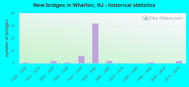
- New bridges - historical statistics
- 11900-1909
- 21920-1929
- 11930-1939
- 61940-1949
- 321950-1959
- 21960-1969
- 11990-1999
- 22010-2019

- Reconstructed bridges - Historical Statistics
- 11940-1949
- 01950-1959
- 01960-1969
- 31970-1979
- 41980-1989
- 11990-1999
- 22000-2009
- 12010-2019
- 12020-2022


- Bridge Condition - Deck
- 2.9%Excellent
- 2.9%Very good
- 17.6%Good
- 44.1%Satisfactory
- 23.5%Fair
- 5.9%Poor
- 2.9%Serious

- Bridge Condition - Superstructure
- 5.9%Excellent
- 11.8%Very good
- 5.9%Good
- 41.2%Satisfactory
- 26.5%Fair
- 8.8%Poor

- Bridge Condition - Substructure
- 5.9%Very good
- 17.6%Good
- 35.3%Satisfactory
- 35.3%Fair
- 5.9%Poor

- Bridge Condition - Channel
- 11.8%Very good
- 58.8%Good
- 11.8%Satisfactory
- 11.8%Fair
- 5.9%Poor
Find on map >> Show street view
Structure Number: 1413153, Location: AT I-80 EXIT 34 (Lat: 40.909489, Lng: -74.569100), Route carried "under" structure: Ramp State highway 15, Year Built: 1959, Structure Length: 0. m, Average Daily Traffic: 25,230 (year 2021), Truck Traffic: 4%, Features Intersected: NJ 15 RAMP D, Facility Carried by Structure: I-80 EB
Minimum Vertical Clearance: 4.50m (14.76ft), Kilometerpoint: 3.476, Lanes on structure: 3, Lanes under structure: 2, Material/Design: Prestressed concrete, Design/Construction: Stringer/Multi-beam, Length of Maximum Span: 30.5m (100.1ft)
Find on map >> Show street view
Structure Number: 1413154, Location: AT I-80 EXIT 34 (Lat: 40.909631, Lng: -74.569781), Route carried "under" structure: Ramp State highway 15, Year Built: 1959, Structure Length: 0. m, Average Daily Traffic: 25,230 (year 2021), Truck Traffic: 4%, Features Intersected: NJ 15 RAMP D, Facility Carried by Structure: I-80 WB
Minimum Vertical Clearance: 4.60m (15.09ft), Kilometerpoint: 3.476, Lanes on structure: 3, Lanes under structure: 2, Material/Design: Prestressed concrete, Design/Construction: Stringer/Multi-beam, Length of Maximum Span: 30.5m (100.1ft)