Bridge Statistics for White Horse, New Jersey (NJ)
Condition, Traffic, Stress, Structural Evaluation, Project Costs
- National Bridge Inventory (NBI) Statistics
- 63Number of bridges
- 1,342ft / 409mTotal length
- $18,047,000Total costs
- 1,820,931Total average daily traffic
- 142,682Total average daily truck traffic
- National Bridge Inventory (NBI) Registered Bridges for White Horse
- No street view available for this location
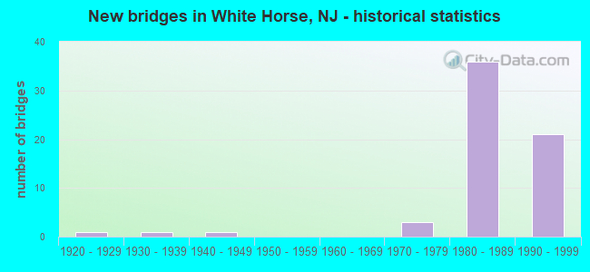
- New bridges - historical statistics
- 11920-1929
- 11930-1939
- 11940-1949
- 31970-1979
- 361980-1989
- 211990-1999


- Bridge Condition - Deck
- 2.9%Very good
- 77.1%Good
- 14.3%Satisfactory
- 5.7%Poor

- Bridge Condition - Superstructure
- 20.0%Very good
- 68.6%Good
- 5.7%Satisfactory
- 5.7%Fair

- Bridge Condition - Substructure
- 2.9%Very good
- 82.9%Good
- 11.4%Satisfactory
- 2.9%Fair

- Bridge Condition - Channel
- 23.1%Excellent
- 38.5%Very good
- 15.4%Good
- 15.4%Satisfactory
- 7.7%Fair
Find on map >> Show street view
Structure Number: 1134177, Location: 0.14 MI EAST OF I-295 (Lat: 40.183969, Lng: -74.718981), Route carried "under" structure: Ramp Interstate 295, Year Built: 1994, Structure Length: 0. m, Average Daily Traffic: 74,803 (year 2020), Truck Traffic: 9%, Features Intersected: I-295 RAMP H, Facility Carried by Structure: ROUTE I-195 WB
Minimum Vertical Clearance: 5.43m (17.81ft), Kilometerpoint: 97.140, Lanes on structure: 3, Lanes under structure: 2, Material/Design: Prestressed concrete, Design/Construction: Stringer/Multi-beam, Length of Maximum Span: 28.0m (91.9ft)
Find on map >> Show street view
Structure Number: 1136153, Location: JCT I-295&I-195/NJ 29 (Lat: 40.183281, Lng: -74.721881), Route carried "under" structure: Interstate 195, Year Built: 1994, Structure Length: 0. m, Average Daily Traffic: 70,546 (year 2020), Truck Traffic: 9%, Features Intersected: I-195, Facility Carried by Structure: I-295 NB
Minimum Vertical Clearance: 6.00m (19.69ft), Kilometerpoint: 0.002, Lanes on structure: 4, Lanes under structure: 7, Material/Design: Steel, Design/Construction: Stringer/Multi-beam, Length of Maximum Span: 39.3m (128.9ft)
Find on map >> Show street view
Structure Number: 1136153, Location: JCT I-295&I-195/NJ 29 (Lat: 40.183281, Lng: -74.721881), Route carried "under" structure: Ramp State highway 195, Year Built: 1994, Structure Length: 0. m, Average Daily Traffic: 50,620 (year 2020), Truck Traffic: 9%, Features Intersected: I-195, Facility Carried by Structure: I-295 NB
Minimum Vertical Clearance: 5.08m (16.67ft), Kilometerpoint: 0.002, Lanes on structure: 4, Lanes under structure: 2, Material/Design: Steel, Design/Construction: Stringer/Multi-beam, Length of Maximum Span: 39.3m (128.9ft)
Find on map >> Show street view
Structure Number: 1136154, Location: AT I-295, EXIT 60 (Lat: 40.183331, Lng: -74.722500), Route carried "under" structure: Interstate 195, Year Built: 1995, Structure Length: 0. m, Average Daily Traffic: 51,603 (year 2021), Truck Traffic: 9%, Features Intersected: I-195, Facility Carried by Structure: I-295 SOUTHBOUND
Minimum Vertical Clearance: 6.32m (20.73ft), Kilometerpoint: 0.032, Lanes on structure: 5, Lanes under structure: 9, Material/Design: Steel, Design/Construction: Stringer/Multi-beam, Length of Maximum Span: 39.3m (128.9ft)
Find on map >> Show street view
Structure Number: 1136155, Location: 0.1 MI WEST OF I-195 (Lat: 40.185689, Lng: -74.721939), Route carried "under" structure: Ramp Interstate 195, Year Built: 1994, Structure Length: 0. m, Average Daily Traffic: 3,448 (year 2020), Truck Traffic: 9%, Features Intersected: RAMP CONNECTING 29 NB, Facility Carried by Structure: ROUTE I-295 NB
Minimum Vertical Clearance: 5.51m (18.08ft), Kilometerpoint: 0.000, Lanes on structure: 3, Lanes under structure: 2, Material/Design: Prestressed concrete, Design/Construction: Stringer/Multi-beam, Length of Maximum Span: 28.0m (91.9ft)
Find on map >> Show street view
Structure Number: 1136156, Location: AT I-295 EXIT 60 (Lat: 40.186050, Lng: -74.722311), Route carried "under" structure: Ramp Interstate 195, Year Built: 1994, Structure Length: 0. m, Average Daily Traffic: 5,513 (year 2021), Truck Traffic: 9%, Features Intersected: I-195 RAMP "H", Facility Carried by Structure: I-295 SOUTHBOUND
Minimum Vertical Clearance: 5.79m (19.00ft), Kilometerpoint: 0.000, Lanes on structure: 4, Lanes under structure: 2, Material/Design: Prestressed concrete, Design/Construction: Stringer/Multi-beam, Length of Maximum Span: 28.0m (91.9ft)
Find on map >> Show street view
Structure Number: 1137157, Location: 0.5 MI N JCT 195,129&29 (Lat: 40.189769, Lng: -74.719469), Route carried "under" structure: Interstate 295, Year Built: 1986, Structure Length: 0. m, Average Daily Traffic: 74,804 (year 2020), Truck Traffic: 9%, Features Intersected: ROUTE I-295, Facility Carried by Structure: INDEPENDENCE AVE.
Minimum Vertical Clearance: 5.05m (16.57ft), Kilometerpoint: 97.591, Lanes on structure: 2, Lanes under structure: 7, Material/Design: Steel, Design/Construction: Stringer/Multi-beam, Length of Maximum Span: 32.6m (107.0ft)
Find on map >> Show street view
Structure Number: 1137158, Location: .8 MI N OF WHITEHORSE CIR (Lat: 40.193331, Lng: -74.721669), Route carried "under" structure: Interstate 295, Year Built: 1986, Structure Length: 0. m, Average Daily Traffic: 66,257 (year 2020), Truck Traffic: 9%, Features Intersected: ROUTE I-295, Facility Carried by Structure: US 206 (S. BROAD)
Minimum Vertical Clearance: 6.68m (21.92ft), Kilometerpoint: 98.025, Lanes on structure: 4, Lanes under structure: 6, Material/Design: Steel continuous, Design/Construction: Stringer/Multi-beam, Length of Maximum Span: 32.0m (105.0ft)
Find on map >> Show street view
Structure Number: 1137159, Location: 0.1 MI. N. OF BROAD ST. (Lat: 40.194711, Lng: -74.716700), Route carried "under" structure: Interstate 295, Year Built: 1986, Structure Length: 0. m, Average Daily Traffic: 74,800 (year 2020), Truck Traffic: 9%, Features Intersected: ROUTE I-295, Facility Carried by Structure: SOUTH CLINTON AVE.
Minimum Vertical Clearance: 6.37m (20.90ft), Kilometerpoint: 98.186, Lanes on structure: 2, Lanes under structure: 6, Material/Design: Steel, Design/Construction: Stringer/Multi-beam, Length of Maximum Span: 32.0m (105.0ft)
Find on map >> Show street view
Structure Number: 1137162, Location: 1.2MI N OF 195/295 INTCHG (Lat: 40.199439, Lng: -74.711669), Route carried "under" structure: County highway 620, Year Built: 1984, Structure Length: 0. m, Average Daily Traffic: 11,539 (year 2021), Truck Traffic: 4%, Features Intersected: ARENA DRIVE (CR 620), Facility Carried by Structure: I-295 NORTHBOUND
Minimum Vertical Clearance: 4.85m (15.91ft), Kilometerpoint: 2.350, Lanes on structure: 4, Lanes under structure: 5, Material/Design: Steel, Design/Construction: Stringer/Multi-beam, Length of Maximum Span: 40.8m (133.9ft)
Find on map >> Show street view
Structure Number: 1137163, Location: AT I-295 EXIT 61 (Lat: 40.199639, Lng: -74.712189), Route carried "under" structure: County highway 620, Year Built: 1984, Structure Length: 0. m, Average Daily Traffic: 12,012 (year 2021), Truck Traffic: 4%, Features Intersected: ARENA DRIVE (CR 620), Facility Carried by Structure: I-295 SB
Minimum Vertical Clearance: 4.93m (16.17ft), Kilometerpoint: 2.382, Lanes on structure: 4, Lanes under structure: 6, Material/Design: Steel, Design/Construction: Stringer/Multi-beam, Length of Maximum Span: 40.8m (133.9ft)
Find on map >> Show street view
Structure Number: 1137164, Location: 1.7MI N OF I195/I295 INT (Lat: 40.205361, Lng: -74.707931), Route carried "under" structure: County highway 622, Year Built: 1984, Structure Length: 0. m, Average Daily Traffic: 8,844 (year 2021), Truck Traffic: 3%, Features Intersected: S.OLDEN AVE.(CO.RTE.622), Facility Carried by Structure: INTERSTATE I295NB
Minimum Vertical Clearance: 5.08m (16.67ft), Kilometerpoint: 0.982, Lanes on structure: 4, Lanes under structure: 2, Material/Design: Steel, Design/Construction: Stringer/Multi-beam, Length of Maximum Span: 29.3m (96.1ft)
Find on map >> Show street view
Structure Number: 1137165, Location: 1.66 MI N OF I-195 JCT (Lat: 40.205381, Lng: -74.708311), Route carried "under" structure: County highway 622, Year Built: 1984, Structure Length: 0. m, Average Daily Traffic: 28,614 (year 2021), Truck Traffic: 3%, Features Intersected: SOUTH OLDEN AVE., Facility Carried by Structure: I-295 SOUTHBOUND
Minimum Vertical Clearance: 4.80m (15.75ft), Kilometerpoint: 1.030, Lanes on structure: 3, Lanes under structure: 2, Material/Design: Steel, Design/Construction: Stringer/Multi-beam, Length of Maximum Span: 29.3m (96.1ft)
Find on map >> Show street view
Structure Number: 1137166, Location: 2.1MI N OF I95/295 INTERC (Lat: 40.211661, Lng: -74.704961), Route carried "under" structure: Interstate 295, Year Built: 1984, Structure Length: 0. m, Average Daily Traffic: 64,901 (year 2021), Truck Traffic: 9%, Features Intersected: I-295, Facility Carried by Structure: KUSER RD (CR 619)
Minimum Vertical Clearance: 5.59m (18.34ft), Kilometerpoint: 100.343, Lanes on structure: 2, Lanes under structure: 6, Material/Design: Steel, Design/Construction: Stringer/Multi-beam, Length of Maximum Span: 31.7m (104.0ft)