Bridge Statistics for White Sulphur Springs, West Virginia (WV)
Condition, Traffic, Stress, Structural Evaluation, Project Costs
- National Bridge Inventory (NBI) Statistics
- 68Number of bridges
- 951ft / 290mTotal length
- $16,965,000Total costs
- 293,743Total average daily traffic
- 65,901Total average daily truck traffic
- National Bridge Inventory (NBI) Registered Bridges for White Sulphur Springs
- No street view available for this location
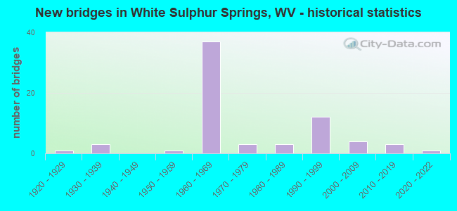
- New bridges - historical statistics
- 11920-1929
- 31930-1939
- 11950-1959
- 371960-1969
- 31970-1979
- 31980-1989
- 121990-1999
- 42000-2009
- 32010-2019
- 12020-2022


- Bridge Condition - Deck
- 8.2%Very good
- 24.5%Good
- 32.7%Satisfactory
- 30.6%Fair
- 4.1%Poor

- Bridge Condition - Superstructure
- 2.0%Very good
- 37.3%Good
- 23.5%Satisfactory
- 27.5%Fair
- 9.8%Poor

- Bridge Condition - Substructure
- 4.0%Very good
- 24.0%Good
- 28.0%Satisfactory
- 40.0%Fair
- 4.0%Poor

- Bridge Condition - Channel
- 12.8%Excellent
- 25.6%Very good
- 28.2%Good
- 12.8%Satisfactory
- 7.7%Fair
- 12.8%Poor

- Bridge Condition - Culverts
- 50.0%Satisfactory
- 50.0%Fair
Find on map >> Show street view
Structure Number: 13A215, Location: 0.01 Miles W. of CR 60/14 (Lat: 37.766939, Lng: -80.355931), Route carried "on" structure: County highway 6075, Year Built: 1997, Status: Open, Structure Length: 1.22m (4.00ft), Average Daily Traffic: 55 (year 2019), Truck Traffic: 10%, Average Future Daily Traffic: 70 (year 2039), Design Load: HS 25 or greater, Features Intersected: HARTS RUN, Facility Carried by Structure: COUNTY ROUTE 60/75
Minimum Vertical Clearance: 30+ m (98+ ft), Kilometerpoint: 0.016, Lanes on structure: 2, Owner: State Highway Agency, Approaching Roadway Width: 4.9m (16.1ft), Skew: 2 degrees, Material/Design: Steel, Design/Construction: Stringer/Multi-beam, Number Of Spans In Main Unit: 1, Length of Maximum Span: 11.9m (39.0ft), Curb-To-Curb Width: 5.6m (18.4ft), Out-to-Out Width: 5.7m (18.7ft)
Condition: Deck: Good, Superstructure: Good, Substructure: Good, Channel: Satisfactory, Operating Rating: 88.9 metric tons, Method Used To Determine Operating Rating: Load Factor (LF), Inventory Rating: 76.2 metric tons, Method Used To Determine Inventory Rating: Load Factor (LF), Structural Evaluation: Better than present minimum criteria, Deck Geometry: Meets minimum limits, Waterway Adequacy: Equal to present desirable criteria, Approach Roadway Alignment: Better than present minimum criteria, Designated Inspection Frequency: Every 48 months, Inspection Date: July 2020, Deck Structure Type: Wood or Timber, Wearing Surface/Protective System: Deck Protection: Other
Find on map >> Show street view
Structure Number: 13A221, Location: 3.10 Miles W. of WV 311 (Lat: 37.799650, Lng: -80.280231), Route carried "on" structure: Interstate 6400, Year Built: 1999, Status: Open, Structure Length: 10.79m (35.40ft), Average Daily Traffic: 8,635 (year 2019), Truck Traffic: 28%, Average Future Daily Traffic: 12,521 (year 2039), Design Load: HS 25 or greater, Features Intersected: US 60, Facility Carried by Structure: I-64 EBL
Minimum Vertical Clearance: 30+ m (98+ ft), Kilometerpoint: 290.149, Lanes on structure: 2, Lanes under structure: 2, Base Highway Network: Yes, Owner: State Highway Agency, Approaching Roadway Width: 13.7m (44.9ft), Skew: 4 degrees, Material/Design: Steel continuous, Design/Construction: Stringer/Multi-beam, Number Of Spans In Main Unit: 4, Length of Maximum Span: 26.7m (87.6ft), Curb-To-Curb Width: 9.7m (31.8ft), Out-to-Out Width: 10.8m (35.4ft)
Condition: Deck: Fair, Superstructure: Satisfactory, Substructure: Fair, Channel: Very good, Operating Rating: 85.3 metric tons, Method Used To Determine Operating Rating: Field evaluation and documented engineering judgment, Inventory Rating: 32.7 metric tons, Method Used To Determine Inventory Rating: Field evaluation and documented engineering judgment, Structural Evaluation: Somewhat better than minimum adequacy, Deck Geometry: Meets minimum limits, Underclear: High priority of corrective action, Waterway Adequacy: Superior to present desirable criteria, Approach Roadway Alignment: Equal to present desirable criteria, Designated Inspection Frequency: Every 24 months, Inspection Date: June 2020, Deck Structure Type: Concrete Cast-file-Place, Wearing Surface/Protective System: Wearing Surface: Monolithic Concrete, Deck Protection: Epoxy Coated Reinforcing
Find on map >> Show street view
Structure Number: 13A222, Location: 3.10 Miles W. of WV 311 (Lat: 37.799850, Lng: -80.280439), Route carried "on" structure: Interstate 6400, Year Built: 1999, Status: Open, Structure Length: 10.79m (35.40ft), Average Daily Traffic: 4,669 (year 2019), Truck Traffic: 28%, Average Future Daily Traffic: 6,770 (year 2039), Design Load: HS 25 or greater, Features Intersected: US 60 & Wades Creek, Facility Carried by Structure: I-64 WBL
Minimum Vertical Clearance: 30+ m (98+ ft), Kilometerpoint: 290.149, Lanes on structure: 2, Lanes under structure: 2, Base Highway Network: Yes, Owner: State Highway Agency, Approaching Roadway Width: 12.5m (41.0ft), Skew: 4 degrees, Material/Design: Steel continuous, Design/Construction: Stringer/Multi-beam, Number Of Spans In Main Unit: 4, Length of Maximum Span: 26.7m (87.6ft), Curb-To-Curb Width: 9.7m (31.8ft), Out-to-Out Width: 10.7m (35.1ft)
Condition: Deck: Satisfactory, Superstructure: Satisfactory, Substructure: Fair, Channel: Excellent, Operating Rating: 85.3 metric tons, Method Used To Determine Operating Rating: Field evaluation and documented engineering judgment, Inventory Rating: 32.7 metric tons, Method Used To Determine Inventory Rating: Field evaluation and documented engineering judgment, Structural Evaluation: Somewhat better than minimum adequacy, Deck Geometry: Meets minimum limits, Underclear: High priority of corrective action, Waterway Adequacy: Superior to present desirable criteria, Approach Roadway Alignment: Equal to present desirable criteria, Designated Inspection Frequency: Every 24 months, Inspection Date: June 2020, Deck Structure Type: Concrete Cast-file-Place, Wearing Surface/Protective System: Wearing Surface: Monolithic Concrete, Deck Protection: Epoxy Coated Reinforcing
Find on map >> Show street view
Structure Number: 13A228, Location: 0.13 Miles N. of CR 36 (Lat: 37.798061, Lng: -80.299961), Route carried "on" structure: County highway 6079, Year Built: 1999, Status: Open, Structure Length: 1.58m (5.18ft), Average Daily Traffic: 50 (year 2019), Average Future Daily Traffic: 66 (year 2039), Design Load: HS 25 or greater, Features Intersected: HOWARD CREEK, Facility Carried by Structure: COUNTY ROUTE 60/79
Minimum Vertical Clearance: 30+ m (98+ ft), Kilometerpoint: 0.209, Lanes on structure: 2, Owner: State Highway Agency, Approaching Roadway Width: 7.6m (24.9ft), Skew: 1 degrees, Material/Design: Prestressed concrete, Design/Construction: Box Beam or Girders - Multiple, Number Of Spans In Main Unit: 1, Length of Maximum Span: 14.6m (47.9ft), Curb-To-Curb Width: 8.8m (28.9ft), Out-to-Out Width: 9.3m (30.5ft)
Condition: Deck: Good, Superstructure: Good, Substructure: Satisfactory, Channel: Good, Operating Rating: 69.8 metric tons, Method Used To Determine Operating Rating: Load Factor (LF), Inventory Rating: 42.6 metric tons, Method Used To Determine Inventory Rating: Load Factor (LF), Structural Evaluation: Equal to present minimum criteria, Deck Geometry: Better than present minimum criteria, Waterway Adequacy: Equal to present desirable criteria, Approach Roadway Alignment: Equal to present desirable criteria, Designated Inspection Frequency: Every 48 months, Inspection Date: March 2020, Deck Structure Type: Other, Wearing Surface/Protective System: Wearing Surface: Bituminous, Deck Protection: Epoxy Coated Reinforcing
Find on map >> Show street view
Structure Number: 13A235, Location: 1.78 Miles E. of CR 60/14 (Lat: 37.778481, Lng: -80.325950), Route carried "on" structure: US 6000, Year Built: 2000, Status: Open, Structure Length: 7.13m (23.39ft), Average Daily Traffic: 8,522 (year 2020), Truck Traffic: 8%, Average Future Daily Traffic: 10,908 (year 2040), Design Load: HS 25 or greater, Features Intersected: HOWARDS CREEK, Facility Carried by Structure: US 60
Minimum Vertical Clearance: 30+ m (98+ ft), Kilometerpoint: 63.456, Lanes on structure: 2, Base Highway Network: Yes, Owner: State Highway Agency, Approaching Roadway Width: 8.5m (27.9ft), Skew: 3 degrees, Material/Design: Steel continuous, Design/Construction: Stringer/Multi-beam, Number Of Spans In Main Unit: 1, Number Of Approach Spans: 2, Length of Maximum Span: 25.0m (82.0ft), Curb-To-Curb Width: 12.1m (39.7ft), Out-to-Out Width: 13.3m (43.6ft)
Condition: Deck: Good, Superstructure: Good, Substructure: Good, Channel: Fair, Operating Rating: 55.3 metric tons, Method Used To Determine Operating Rating: Load Factor (LF), Inventory Rating: 32.7 metric tons, Method Used To Determine Inventory Rating: Load Factor (LF), Structural Evaluation: Better than present minimum criteria, Deck Geometry: Somewhat better than minimum adequacy, Waterway Adequacy: Equal to present desirable criteria, Approach Roadway Alignment: Equal to present desirable criteria, Designated Inspection Frequency: Every 24 months, Inspection Date: August 2021, Deck Structure Type: Concrete Cast-file-Place, Wearing Surface/Protective System: Wearing Surface: Latex Concrete, Deck Protection: Epoxy Coated Reinforcing
Find on map >> Show street view
Structure Number: 13A24, Location: 0.34 Miles W. of CR 60/14 (Lat: 37.770669, Lng: -80.361681), Route carried "on" structure: Interstate 6400, Year Built: 1967, Status: Open, Structure Length: 10.97m (35.99ft), Average Daily Traffic: 10,015 (year 2019), Truck Traffic: 28%, Average Future Daily Traffic: 14,522 (year 2039), Features Intersected: HARTS RUN, Facility Carried by Structure: I-64 EBL & WBL
Minimum Vertical Clearance: 30+ m (98+ ft), Kilometerpoint: 281.587, Lanes on structure: 5, Base Highway Network: Yes, Owner: State Highway Agency, Approaching Roadway Width: 13.4m (44.0ft), Material/Design: Steel, Design/Construction: Culvert, Number Of Spans In Main Unit: 3, Length of Maximum Span: 27.6m (90.6ft)
Condition: Channel: Good, Culverts: Fair, Operating Rating: 71.7 metric tons, Method Used To Determine Operating Rating: Field evaluation and documented engineering judgment, Inventory Rating: 32.7 metric tons, Method Used To Determine Inventory Rating: Field evaluation and documented engineering judgment, Structural Evaluation: Somewhat better than minimum adequacy, Waterway Adequacy: Superior to present desirable criteria, Approach Roadway Alignment: Equal to present desirable criteria, Designated Inspection Frequency: Every 24 months, Inspection Date: September 2020
Find on map >> Show street view
Structure Number: 13A243, Location: 0.15 Miles N. of US 60 (Lat: 37.793489, Lng: -80.304569), Route carried "on" structure: County highway 6087, Year Built: 2004, Status: Open, Structure Length: 4.79m (15.72ft), Average Daily Traffic: 30 (year 2019), Average Future Daily Traffic: 40 (year 2039), Design Load: HL 93, Features Intersected: HOWARD CREEK, Facility Carried by Structure: COUNTY ROUTE 60/87
Minimum Vertical Clearance: 30+ m (98+ ft), Kilometerpoint: 0.241, Lanes on structure: 2, Owner: State Highway Agency, Approaching Roadway Width: 7.3m (24.0ft), Skew: 2 degrees, Material/Design: Steel, Design/Construction: Truss - Thru, Number Of Spans In Main Unit: 1, Length of Maximum Span: 46.5m (152.6ft), Curb or Sidewalk Widths: Left: 0.0m, Right: 1.5m (4.9ft), Curb-To-Curb Width: 7.9m (25.9ft), Out-to-Out Width: 9.4m (30.8ft)
Condition: Deck: Good, Superstructure: Good, Substructure: Satisfactory, Channel: Excellent, Operating Rating: 39.0 metric tons, Method Used To Determine Operating Rating: Load and Resistance Factor (LRFR), Inventory Rating: 29.9 metric tons, Method Used To Determine Inventory Rating: Load and Resistance Factor (LRFR), Structural Evaluation: Equal to present minimum criteria, Deck Geometry: Equal to present minimum criteria, Waterway Adequacy: Superior to present desirable criteria, Approach Roadway Alignment: Somewhat better than minimum adequacy, Designated Inspection Frequency: Every 24 months, Critical Feature Inspection Frequency: Every 24 months, Inspection Date: April 2020, Critical Feature Inspection Date: April 2020, Deck Structure Type: Corrugated Steel, Wearing Surface/Protective System: Wearing Surface: Bituminous
Find on map >> Show street view
Structure Number: 13A244, Location: 0.14 Miles E. of CR 92/6 (Lat: 37.846069, Lng: -80.249689), Route carried "on" structure: County highway 9207, Year Built: 2005, Status: Open, Structure Length: 0.95m (3.12ft), Average Daily Traffic: 31 (year 2019), Truck Traffic: 10%, Average Future Daily Traffic: 40 (year 2039), Design Load: HS 25 or greater, Features Intersected: HOWARDS CREEK, Facility Carried by Structure: CR 92/7
Minimum Vertical Clearance: 30+ m (98+ ft), Kilometerpoint: 0.225, Lanes on structure: 1, Owner: State Highway Agency, Approaching Roadway Width: 3.4m (11.2ft), Material/Design: Steel, Design/Construction: Stringer/Multi-beam, Number Of Spans In Main Unit: 1, Length of Maximum Span: 8.8m (28.9ft), Curb-To-Curb Width: 4.8m (15.7ft), Out-to-Out Width: 4.9m (16.1ft)
Condition: Deck: Fair, Superstructure: Good, Substructure: Fair, Channel: Fair, Operating Rating: 88.9 metric tons, Method Used To Determine Operating Rating: Load Factor (LF), Inventory Rating: 85.3 metric tons, Method Used To Determine Inventory Rating: Load Factor (LF), Structural Evaluation: Somewhat better than minimum adequacy, Deck Geometry: Equal to present desirable criteria, Waterway Adequacy: Equal to present desirable criteria, Approach Roadway Alignment: Equal to present minimum criteria, Designated Inspection Frequency: Every 24 months, Inspection Date: October 2021, Deck Structure Type: Wood or Timber
Find on map >> Show street view
Structure Number: 13A246, Location: 0.02 Miles E. of CR 36/1 (Lat: 37.830369, Lng: -80.279189), Route carried "on" structure: County highway 3606, Year Built: 2006, Status: Open, Structure Length: 1.65m (5.41ft), Average Daily Traffic: 50 (year 2016), Average Future Daily Traffic: 66 (year 2036), Design Load: HS 25 or greater, Features Intersected: JERICHO DRAFT, Facility Carried by Structure: COUNTY ROUTE 36/6
Minimum Vertical Clearance: 30+ m (98+ ft), Kilometerpoint: 0.032, Lanes on structure: 2, Owner: State Highway Agency, Approaching Roadway Width: 3.4m (11.2ft), Material/Design: Prestressed concrete, Design/Construction: Box Beam or Girders - Multiple, Number Of Spans In Main Unit: 1, Length of Maximum Span: 15.2m (49.9ft), Curb-To-Curb Width: 6.4m (21.0ft), Out-to-Out Width: 6.4m (21.0ft)
Condition: Deck: Very good, Superstructure: Very good, Substructure: Good, Channel: Satisfactory, Operating Rating: 88.9 metric tons, Method Used To Determine Operating Rating: Load Factor (LF), Inventory Rating: 77.1 metric tons, Method Used To Determine Inventory Rating: Load Factor (LF), Structural Evaluation: Better than present minimum criteria, Deck Geometry: Somewhat better than minimum adequacy, Waterway Adequacy: Equal to present minimum criteria, Approach Roadway Alignment: Better than present minimum criteria, Designated Inspection Frequency: Every 48 months, Inspection Date: May 2018, Deck Structure Type: Other, Wearing Surface/Protective System: Wearing Surface: Bituminous, Membrane: Preformed Fabric
Find on map >> Show street view
Structure Number: 13A259, Location: 0.91 Miles S. of CR. 50/1 (Lat: 37.770411, Lng: -80.279950), Route carried "on" structure: County highway 500, Year Built: 2011, Status: Open, Structure Length: 2.83m (9.28ft), Average Daily Traffic: 1,000 (year 2019), Truck Traffic: 2%, Average Future Daily Traffic: 1,280 (year 2039), Design Load: HL 93, Features Intersected: Tuckahoe Run, Facility Carried by Structure: COUNTY ROUTE 50
Minimum Vertical Clearance: 30+ m (98+ ft), Kilometerpoint: 3.669, Lanes on structure: 2, Owner: State Highway Agency, Approaching Roadway Width: 5.5m (18.0ft), Material/Design: Prestressed concrete, Design/Construction: Box Beam or Girders - Multiple, Number Of Spans In Main Unit: 2, Length of Maximum Span: 13.4m (44.0ft), Curb-To-Curb Width: 7.3m (24.0ft), Out-to-Out Width: 7.3m (24.0ft)
Condition: Deck: Good, Superstructure: Good, Substructure: Fair, Channel: Satisfactory, Operating Rating: 75.3 metric tons, Method Used To Determine Operating Rating: Load and Resistance Factor (LRFR), Inventory Rating: 58.0 metric tons, Method Used To Determine Inventory Rating: Load and Resistance Factor (LRFR), Structural Evaluation: Somewhat better than minimum adequacy, Deck Geometry: Meets minimum limits, Waterway Adequacy: Equal to present desirable criteria, Approach Roadway Alignment: Equal to present minimum criteria, Designated Inspection Frequency: Every 24 months, Inspection Date: September 2021, Deck Structure Type: Other, Wearing Surface/Protective System: Wearing Surface: Bituminous
Find on map >> Show street view
Structure Number: 13A26, Location: 0.22 Miles N. of WV 92 (Lat: 37.816181, Lng: -80.280631), Route carried "on" structure: County highway 1505, Year Built: 2012, Status: Open, Structure Length: 1.42m (4.66ft), Average Daily Traffic: 399 (year 2019), Truck Traffic: 10%, Average Future Daily Traffic: 511 (year 2039), Design Load: HL 93, Features Intersected: HOWARDS CREEK, Facility Carried by Structure: COUNTY ROUTE 15/5
Minimum Vertical Clearance: 30+ m (98+ ft), Kilometerpoint: 0.354, Lanes on structure: 1, Owner: State Highway Agency, Approaching Roadway Width: 4.3m (14.1ft), Skew: 2 degrees, Material/Design: Steel, Design/Construction: Stringer/Multi-beam, Number Of Spans In Main Unit: 1, Length of Maximum Span: 14.2m (46.6ft), Curb-To-Curb Width: 5.3m (17.4ft), Out-to-Out Width: 5.4m (17.7ft)
Condition: Deck: Satisfactory, Superstructure: Satisfactory, Substructure: Good, Channel: Excellent, Operating Rating: 47.2 metric tons, Method Used To Determine Operating Rating: Load and Resistance Factor (LRFR), Inventory Rating: 36.3 metric tons, Method Used To Determine Inventory Rating: Load and Resistance Factor (LRFR), Structural Evaluation: Equal to present minimum criteria, Deck Geometry: High priority of replacement, Waterway Adequacy: Superior to present desirable criteria, Approach Roadway Alignment: Somewhat better than minimum adequacy, Length Of Structure Improvement: 1.46m (4.79ft), Designated Inspection Frequency: Every 24 months, Inspection Date: July 2020, Bridge Improvement Cost: $104,000, Roadway Improvement Cost: $102,000, Total Project Cost: $227,000 ( Estimate for 2020), Deck Structure Type: Wood or Timber, Wearing Surface/Protective System: Deck Protection: Other
Find on map >> Show street view
Structure Number: 13A268, Location: 0.04 Miles North of CR 50 (Lat: 37.792269, Lng: -80.293881), Route carried "on" structure: County highway 503, Year Built: 2016, Status: Open, Structure Length: 2.12m (6.96ft), Average Daily Traffic: 30 (year 2019), Truck Traffic: 10%, Average Future Daily Traffic: 38 (year 2039), Design Load: HL 93, Features Intersected: Dry Creek, Facility Carried by Structure: COUNTY ROUTE 50/3
Minimum Vertical Clearance: 30+ m (98+ ft), Kilometerpoint: 0.064, Lanes on structure: 1, Owner: State Highway Agency, Approaching Roadway Width: 4.3m (14.1ft), Material/Design: Steel, Design/Construction: Stringer/Multi-beam, Number Of Spans In Main Unit: 1, Length of Maximum Span: 20.0m (65.6ft), Curb-To-Curb Width: 4.8m (15.7ft), Out-to-Out Width: 4.9m (16.1ft)
Condition: Deck: Very good, Superstructure: Good, Substructure: Very good, Channel: Very good, Operating Rating: 45.4 metric tons, Method Used To Determine Operating Rating: Load and Resistance Factor (LRFR), Inventory Rating: 35.4 metric tons, Method Used To Determine Inventory Rating: Load and Resistance Factor (LRFR), Structural Evaluation: Better than present minimum criteria, Deck Geometry: Equal to present desirable criteria, Waterway Adequacy: Better than present minimum criteria, Approach Roadway Alignment: Equal to present desirable criteria, Designated Inspection Frequency: Every 24 months, Inspection Date: September 2020, Deck Structure Type: Wood or Timber, Wearing Surface/Protective System: Deck Protection: Other
Find on map >> Show street view
Structure Number: 13A9, Location: 0.20 Miles N. of US 60 (Lat: 37.798750, Lng: -80.299600), Route carried "on" structure: City street N1700, Year Built: 1973, Status: Posted for load, Structure Length: 1.09m (3.58ft), Average Daily Traffic: 50 (year 2019), Truck Traffic: 2%, Average Future Daily Traffic: 66 (year 2039), Features Intersected: WADES CREEK, Facility Carried by Structure: MILL HILL DRIVE
Minimum Vertical Clearance: 30+ m (98+ ft), Kilometerpoint: 0.016, Lanes on structure: 1, Owner: City or Municipal Highway Agency, Approaching Roadway Width: 3.4m (11.2ft), Material/Design: Steel, Design/Construction: Stringer/Multi-beam, Number Of Spans In Main Unit: 1, Length of Maximum Span: 9.8m (32.2ft), Curb or Sidewalk Widths: Left: 0.7m (2.3ft), Right: 0.0m, Curb-To-Curb Width: 4.8m (15.7ft), Out-to-Out Width: 4.9m (16.1ft)
Condition: Deck: Good, Superstructure: Fair, Substructure: Satisfactory, Channel: Good, Operating Rating: 13.6 metric tons, Method Used To Determine Operating Rating: Load Factor (LF), Inventory Rating: 8.2 metric tons, Method Used To Determine Inventory Rating: Load Factor (LF), Structural Evaluation: High priority of corrective action, Deck Geometry: Equal to present desirable criteria, Waterway Adequacy: Equal to present minimum criteria, Approach Roadway Alignment: Somewhat better than minimum adequacy, Bridge Posting: Required (Relationship of Operating Rating to Maximum Legal Load: > 39.9% below), Designated Inspection Frequency: Every 24 months, Inspection Date: November 2020, Deck Structure Type: Wood or Timber, Wearing Surface/Protective System: Deck Protection: Other
Find on map >> Show street view
Structure Number: 51270-00027, Location: NE CORNER OF HATCHERY (Lat: 37.801500, Lng: -80.293000), Route carried "on" structure: Federal lands road , Year Built: 1950, Year Reconstructed: 1983, Status: Posted for load, Structure Length: 1.28m (4.20ft), Average Daily Traffic: 30 (year 2021), Average Future Daily Traffic: 30 (year 2041), Features Intersected: WADES CREEK, Facility Carried by Structure: HINES AVE.
Minimum Vertical Clearance: 30.48m (100.00ft), Kilometerpoint: 0.161, Lanes on structure: 1, Owner: Bureau of Fish and Wildlife, Approaching Roadway Width: 3.0m (9.8ft), Material/Design: Steel, Design/Construction: Stringer/Multi-beam, Number Of Spans In Main Unit: 1, Length of Maximum Span: 11.6m (38.1ft), Curb-To-Curb Width: 3.5m (11.5ft), Out-to-Out Width: 4.2m (13.8ft)
Condition: Deck: Satisfactory, Superstructure: Satisfactory, Substructure: Good, Channel: Good, Operating Rating: 10.9 metric tons, Method Used To Determine Operating Rating: Allowable Stress (AS), Inventory Rating: 7.3 metric tons, Method Used To Determine Inventory Rating: Allowable Stress (AS), Structural Evaluation: High priority of replacement, Deck Geometry: High priority of corrective action, Waterway Adequacy: Better than present minimum criteria, Approach Roadway Alignment: Equal to present minimum criteria, Bridge Posting: Required (Relationship of Operating Rating to Maximum Legal Load: > 39.9% below), Length Of Structure Improvement: 1.98m (6.50ft), Designated Inspection Frequency: Every 24 months, Inspection Date: May 2021, Bridge Improvement Cost: $321,000, Roadway Improvement Cost: $33,000, Total Project Cost: $710,000, Deck Structure Type: Wood or Timber, Wearing Surface/Protective System: Wearing Surface: Wood or Timber
Find on map >> Show street view
Structure Number: 92106000032397, Location: NO DATA ENTERED (Lat: 37.826256, Lng: -80.237908), Route carried "on" structure: Federal lands road 719B, Year Built: 2020, Status: Open, Structure Length: 1.13m (3.71ft), Average Daily Traffic: 10 (year 2020), Average Future Daily Traffic: 15 (year 2042), Design Load: HL 93, Features Intersected: SULPHUR LICK
Minimum Vertical Clearance: 30+ m (98+ ft), Kilometerpoint: 0.160, Lanes on structure: 1, Owner: U.S. Forest Service, Approaching Roadway Width: 4.3m (14.1ft), Material/Design: Prestressed concrete, Design/Construction: Box Beam or Girders - Multiple, Number Of Spans In Main Unit: 1, Length of Maximum Span: 9.8m (32.2ft), Curb-To-Curb Width: 5.4m (17.7ft), Out-to-Out Width: 6.1m (20.0ft)
Condition: Deck: Good, Superstructure: Good, Substructure: Good, Channel: Good, Deck Geometry: High priority of corrective action, Waterway Adequacy: Equal to present minimum criteria, Approach Roadway Alignment: High priority of corrective action, Designated Inspection Frequency: Every 24 months, Inspection Date: August 2020, Deck Structure Type: Concrete Precast Panels, Wearing Surface/Protective System: Wearing Surface: Monolithic Concrete
Find on map >> Show street view
Structure Number: 13A098, Location: 0.55 Miles S. of CR 50/1 (Lat: 37.752189, Lng: -80.273250), Route carried "under" structure: County highway 5000, Year Built: 1920, Structure Length: 0. m, Average Daily Traffic: 658 (year 2019), Truck Traffic: 10%, Features Intersected: COUNTY ROUTE 50, Facility Carried by Structure: CSX RAILROAD
Minimum Vertical Clearance: 3.76m (12.34ft), Kilometerpoint: 6.019, Lanes under structure: 1, Length of Maximum Span: 8.3m (27.2ft)
Find on map >> Show street view
Structure Number: 13A126, Location: 0.34 Miles S. of US 60 (Lat: 37.767700, Lng: -80.356050), Route carried "under" structure: County highway 6014, Year Built: 1930, Structure Length: 0. m, Average Daily Traffic: 361 (year 2019), Truck Traffic: 1%, Features Intersected: CR 60/14 & HARTS RUN, Facility Carried by Structure: CSX RAILROAD
Minimum Vertical Clearance: 2.79m (9.15ft), Kilometerpoint: 9.849, Lanes under structure: 1, Material/Design: Masonry, Design/Construction: Culvert, Length of Maximum Span: 7.7m (25.3ft)
Find on map >> Show street view
Structure Number: 13A137, Location: 0.24 Miles S. of US 60 (Lat: 37.781539, Lng: -80.304869), Route carried "under" structure: Interstate 6400, Year Built: 1965, Structure Length: 0. m, Average Daily Traffic: 8,702 (year 0015), Truck Traffic: 22%, Features Intersected: I-64 EBL & WBL, Facility Carried by Structure: COUNTY ROUTE 60/34
Minimum Vertical Clearance: 5.23m (17.16ft), Kilometerpoint: 287.831, Lanes on structure: 2, Lanes under structure: 4, Length of Maximum Span: 20.3m (66.6ft)
Find on map >> Show street view
Structure Number: 13A152, Location: 2.57 Miles W. of CR 60/14 (Lat: 37.790225, Lng: -80.384586), Route carried "under" structure: County highway 3800, Year Built: 1967, Structure Length: 0. m, Average Daily Traffic: 1,000 (year 0012), Truck Traffic: 2%, Features Intersected: CR 38 & GREENBRIER RIVER, Facility Carried by Structure: I-64 EBL
Minimum Vertical Clearance: 17.68m (58.01ft), Kilometerpoint: 1.448, Lanes on structure: 2, Lanes under structure: 1, Length of Maximum Span: 49.8m (163.4ft)
Find on map >> Show street view
Structure Number: 13A153, Location: 2.57 Miles W. of CR 60/14 (Lat: 37.790231, Lng: -80.384389), Route carried "under" structure: County highway 3800, Year Built: 1967, Structure Length: 0. m, Average Daily Traffic: 1,000 (year 0012), Truck Traffic: 2%, Features Intersected: CR 38 & GREENBRIER RIVER, Facility Carried by Structure: I-64 WBL
Minimum Vertical Clearance: 17.68m (58.01ft), Kilometerpoint: 1.835, Lanes on structure: 2, Lanes under structure: 2, Length of Maximum Span: 49.8m (163.4ft)
Find on map >> Show street view
Structure Number: 13A154, Location: 1.97 Miles W. of CR 60/14 (Lat: 37.782261, Lng: -80.381869), Route carried "under" structure: County highway 6020, Year Built: 1967, Structure Length: 0. m, Average Daily Traffic: 100 (year 0012), Features Intersected: COUNTY ROUTE 60/20, Facility Carried by Structure: I-64 EBL & WBL
Minimum Vertical Clearance: 4.37m (14.34ft), Kilometerpoint: 0.869, Lanes on structure: 4, Lanes under structure: 1, Length of Maximum Span: 6.7m (22.0ft)
Find on map >> Show street view
Structure Number: 13A155, Location: 1.21 Miles W. of CR 60/14 (Lat: 37.773356, Lng: -80.376833), Route carried "under" structure: US 6000, Year Built: 1967, Structure Length: 0. m, Average Daily Traffic: 5,500 (year 0016), Truck Traffic: 8%, Features Intersected: U.S. 60, Facility Carried by Structure: I-64 EBL
Minimum Vertical Clearance: 7.62m (25.00ft), Kilometerpoint: 58.709, Lanes on structure: 2, Lanes under structure: 2, Length of Maximum Span: 36.9m (121.1ft)
Find on map >> Show street view
Structure Number: 13A156, Location: 1.21 Miles W. of CR 60/14 (Lat: 37.773250, Lng: -80.376319), Route carried "under" structure: US 6000, Year Built: 1967, Structure Length: 0. m, Average Daily Traffic: 5,500 (year 0015), Truck Traffic: 7%, Features Intersected: US 60, Facility Carried by Structure: I-64 WBL
Minimum Vertical Clearance: 6.02m (19.75ft), Kilometerpoint: 58.709, Lanes on structure: 2, Lanes under structure: 2, Length of Maximum Span: 36.9m (121.1ft)
Find on map >> Show street view
Structure Number: 13A159, Location: 1.21 Miles E. of US 60 (Lat: 37.770781, Lng: -80.356314), Route carried "under" structure: County highway 6014, Year Built: 1967, Structure Length: 0. m, Average Daily Traffic: 550 (year 0009), Truck Traffic: 15%, Features Intersected: COUNTY ROUTE 60/14, Facility Carried by Structure: I 64 EBL
Minimum Vertical Clearance: 4.83m (15.85ft), Kilometerpoint: 10.123, Lanes on structure: 2, Lanes under structure: 2, Length of Maximum Span: 15.5m (50.9ft)
Find on map >> Show street view
Structure Number: 13A16, Location: 0.00 Miles E. of CR 60/14 (Lat: 37.770972, Lng: -80.356325), Route carried "under" structure: County highway 6014, Year Built: 1967, Structure Length: 0. m, Average Daily Traffic: 550 (year 0012), Truck Traffic: 15%, Features Intersected: COUNTY ROUTE 60/14, Facility Carried by Structure: I-64 WBL
Minimum Vertical Clearance: 4.50m (14.76ft), Kilometerpoint: 10.123, Lanes on structure: 2, Lanes under structure: 2, Length of Maximum Span: 15.5m (50.9ft)
Find on map >> Show street view
Structure Number: 13A165, Location: 4.05 Miles S. of CR 60/14 (Lat: 37.791725, Lng: -80.292817), Route carried "under" structure: County highway 5000, Year Built: 1965, Structure Length: 0. m, Average Daily Traffic: 1,100 (year 0012), Truck Traffic: 2%, Features Intersected: Dry Creek and CR 50, Facility Carried by Structure: I-64 EBL
Minimum Vertical Clearance: 22.35m (73.33ft), Kilometerpoint: 0.676, Lanes on structure: 2, Lanes under structure: 2, Length of Maximum Span: 57.6m (189.0ft)
Find on map >> Show street view
Structure Number: 13A166, Location: 4.03 Miles E. of CR 60/14 (Lat: 37.791808, Lng: -80.292994), Route carried "under" structure: County highway 5000, Year Built: 1965, Structure Length: 0. m, Average Daily Traffic: 1,219 (year 0015), Truck Traffic: 2%, Features Intersected: Dry Creek and CR 50, Facility Carried by Structure: I-64 WBL
Minimum Vertical Clearance: 22.35m (73.33ft), Kilometerpoint: 0.676, Lanes on structure: 2, Lanes under structure: 2, Length of Maximum Span: 57.6m (189.0ft)
Find on map >> Show street view
Structure Number: 13A184, Location: 0.35 Miles S. of I-64 (Lat: 37.782364, Lng: -80.232758), Route carried "under" structure: Interstate 6400, Year Built: 1965, Structure Length: 0. m, Average Daily Traffic: 9,500 (year 0011), Truck Traffic: 22%, Features Intersected: I-64 EBL & WBL, Facility Carried by Structure: WV 311
Minimum Vertical Clearance: 5.18m (16.99ft), Kilometerpoint: 295.814, Lanes on structure: 2, Lanes under structure: 4, Length of Maximum Span: 27.4m (89.9ft)
Find on map >> Show street view
Structure Number: 13A221, Location: 3.10 Miles W. of WV 311 (Lat: 37.799686, Lng: -80.280506), Route carried "under" structure: US 6000, Year Built: 1999, Structure Length: 0. m, Average Daily Traffic: 8,909 (year 0015), Truck Traffic: 8%, Features Intersected: US 60, Facility Carried by Structure: I-64 EBL
Minimum Vertical Clearance: 10.64m (34.91ft), Kilometerpoint: 68.381, Lanes on structure: 2, Lanes under structure: 2, Length of Maximum Span: 26.7m (87.6ft)
Find on map >> Show street view
Structure Number: 13A222, Location: 3.10 Miles W. of WV 311 (Lat: 37.799878, Lng: -80.280678), Route carried "under" structure: US 6000, Year Built: 1999, Structure Length: 0. m, Average Daily Traffic: 7,000 (year 0012), Truck Traffic: 8%, Features Intersected: US 60 & Wades Creek, Facility Carried by Structure: I-64 WBL
Minimum Vertical Clearance: 12.07m (39.60ft), Kilometerpoint: 68.381, Lanes on structure: 2, Lanes under structure: 2, Length of Maximum Span: 26.7m (87.6ft)