Bridge Statistics for Williamsport, Pennsylvania (PA)
Condition, Traffic, Stress, Structural Evaluation, Project Costs
- National Bridge Inventory (NBI) Statistics
- 81Number of bridges
- 1,299ft / 396mTotal length
- $20,268,000Total costs
- 847,035Total average daily traffic
- 108,510Total average daily truck traffic
- National Bridge Inventory (NBI) Registered Bridges for Williamsport
- No street view available for this location
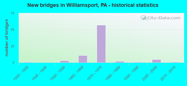
- New bridges - historical statistics
- 11930-1939
- 31950-1959
- 111960-1969
- 571970-1979
- 21980-1989
- 11990-1999
- 52000-2009
- 12010-2019

- Reconstructed bridges - Historical Statistics
- 11950-1959
- 01960-1969
- 11970-1979
- 01980-1989
- 81990-1999
- 22000-2009
- 32010-2019


- Bridge Condition - Deck
- 2.1%Excellent
- 8.3%Very good
- 66.7%Good
- 20.8%Satisfactory
- 2.1%Fair

- Bridge Condition - Superstructure
- 20.4%Very good
- 40.8%Good
- 26.5%Satisfactory
- 12.2%Fair

- Bridge Condition - Substructure
- 2.0%Very good
- 32.7%Good
- 42.9%Satisfactory
- 22.4%Fair

- Bridge Condition - Channel
- 7.4%Very good
- 18.5%Good
- 22.2%Satisfactory
- 29.6%Fair
- 22.2%Poor

- Bridge Condition - Culverts
- 50.0%Good
- 25.0%Satisfactory
- 25.0%Fair
Find on map >> Show street view
Structure Number: 24985, Location: 4 MI E OF SALLADASBURG (Lat: 41.275992, Lng: -77.142119), Route carried "on" structure: State highway , Year Built: 1962, Status: Open, Structure Length: 0.94m (3.08ft), Average Daily Traffic: 549 (year 2022), Truck Traffic: 9%, Average Future Daily Traffic: 770 (year 2032), Features Intersected: OVER QUENSHUKENY RUN, Facility Carried by Structure: SR 3013
Minimum Vertical Clearance: 30+ m (98+ ft), Kilometerpoint: 4.878, Lanes on structure: 2, Owner: State Highway Agency, Approaching Roadway Width: 6.1m (20.0ft), Skew: 3 degrees, Material/Design: Concrete, Design/Construction: Slab, Number Of Spans In Main Unit: 1, Length of Maximum Span: 9.1m (29.9ft), Curb or Sidewalk Widths: Left: 0.5m (1.6ft), Right: 0.5m (1.6ft), Curb-To-Curb Width: 9.9m (32.5ft), Out-to-Out Width: 11.3m (37.1ft)
Condition: Deck: Satisfactory, Superstructure: Satisfactory, Substructure: Good, Channel: Poor, Operating Rating: 54.4 metric tons, Method Used To Determine Operating Rating: Field evaluation and documented engineering judgment, Inventory Rating: 32.7 metric tons, Method Used To Determine Inventory Rating: Field evaluation and documented engineering judgment, Structural Evaluation: Equal to present minimum criteria, Deck Geometry: Equal to present minimum criteria, Waterway Adequacy: Better than present minimum criteria, Approach Roadway Alignment: Equal to present desirable criteria, Length Of Structure Improvement: 0.90m (2.95ft), Designated Inspection Frequency: Every 24 months, Inspection Date: May 2021, Deck Structure Type: Concrete Cast-file-Place, Wearing Surface/Protective System: Wearing Surface: Bituminous, Membrane: Preformed Fabric
Find on map >> Show street view
Structure Number: 24988, Location: 2 M NW WILLIAMSPORT (Lat: 41.268264, Lng: -77.087708), Route carried "on" structure: State highway , Year Built: 1969, Status: Open, Structure Length: 0.82m (2.69ft), Average Daily Traffic: 738 (year 2022), Truck Traffic: 4%, Average Future Daily Traffic: 1,065 (year 2032), Design Load: HS 20, Features Intersected: BOTTLE RUN, Facility Carried by Structure: SR 3014
Minimum Vertical Clearance: 30+ m (98+ ft), Kilometerpoint: 2.214, Lanes on structure: 2, Owner: State Highway Agency, Approaching Roadway Width: 7.3m (24.0ft), Skew: 4 degrees, Material/Design: Concrete, Design/Construction: Slab, Number Of Spans In Main Unit: 1, Length of Maximum Span: 7.6m (24.9ft), Curb or Sidewalk Widths: Left: 0.2m (0.7ft), Right: 0.2m (0.7ft), Curb-To-Curb Width: 10.2m (33.5ft), Out-to-Out Width: 11.4m (37.4ft)
Condition: Deck: Good, Superstructure: Good, Substructure: Good, Channel: Fair, Operating Rating: 54.4 metric tons, Method Used To Determine Operating Rating: Field evaluation and documented engineering judgment, Inventory Rating: 32.7 metric tons, Method Used To Determine Inventory Rating: Field evaluation and documented engineering judgment, Structural Evaluation: Better than present minimum criteria, Deck Geometry: Equal to present minimum criteria, Waterway Adequacy: Equal to present minimum criteria, Approach Roadway Alignment: Equal to present desirable criteria, Length Of Structure Improvement: 1.40m (4.59ft), Designated Inspection Frequency: Every 24 months, Inspection Date: April 2020, Bridge Improvement Cost: $4,000, Roadway Improvement Cost: $13,000, Total Project Cost: $59,000, Wearing Surface/Protective System: Wearing Surface: Bituminous, Membrane: Preformed Fabric
Find on map >> Show street view
Structure Number: 2499, Location: 3 MI EAST OF LINDEN (Lat: 41.239908, Lng: -77.090997), Route carried "on" structure: State highway , Year Built: 1969, Year Reconstructed: 2006, Status: Open, Structure Length: 1.49m (4.89ft), Average Daily Traffic: 804 (year 2020), Truck Traffic: 7%, Average Future Daily Traffic: 1,460 (year 2032), Features Intersected: OVER DAUGHERTY'S RUN, Facility Carried by Structure: S.R. 3015
Minimum Vertical Clearance: 30+ m (98+ ft), Kilometerpoint: 0.695, Lanes on structure: 2, Owner: State Highway Agency, Approaching Roadway Width: 9.8m (32.2ft), Skew: 6 degrees, Material/Design: Steel, Design/Construction: Stringer/Multi-beam, Number Of Spans In Main Unit: 1, Length of Maximum Span: 14.3m (46.9ft), Curb-To-Curb Width: 9.7m (31.8ft), Out-to-Out Width: 10.5m (34.4ft)
Condition: Deck: Good, Superstructure: Good, Substructure: Satisfactory, Channel: Satisfactory, Operating Rating: 78.9 metric tons, Method Used To Determine Operating Rating: Load Factor (LF), Inventory Rating: 47.2 metric tons, Method Used To Determine Inventory Rating: Load Factor (LF), Structural Evaluation: Equal to present minimum criteria, Deck Geometry: Equal to present minimum criteria, Waterway Adequacy: Superior to present desirable criteria, Approach Roadway Alignment: Equal to present desirable criteria, Length Of Structure Improvement: 1.50m (4.92ft), Designated Inspection Frequency: Every 48 months, Inspection Date: January 2019, Bridge Improvement Cost: $8,000, Roadway Improvement Cost: $50,000, Total Project Cost: $110,000, Deck Structure Type: Concrete Cast-file-Place, Wearing Surface/Protective System: Wearing Surface: Monolithic Concrete, Deck Protection: Epoxy Coated Reinforcing
Find on map >> Show street view
Structure Number: 24996, Location: MEMORIAL AVENUE (Lat: 41.244667, Lng: -77.048000), Route carried "on" structure: Spur State highway , Year Built: 1987, Status: Open, Structure Length: 8.23m (27.00ft), Average Daily Traffic: 2,972 (year 2022), Truck Traffic: 4%, Average Future Daily Traffic: 4,377 (year 2032), Design Load: HS 25 or greater, Features Intersected: LYCOMING CREEK, Facility Carried by Structure: SR 3021 MEMORIAL A
Minimum Vertical Clearance: 30+ m (98+ ft), Kilometerpoint: 0.000, Lanes on structure: 2, Owner: State Highway Agency, Approaching Roadway Width: 8.5m (27.9ft), Material/Design: Steel continuous, Design/Construction: Stringer/Multi-beam, Number Of Spans In Main Unit: 3, Length of Maximum Span: 32.3m (106.0ft), Curb or Sidewalk Widths: Left: 1.5m (4.9ft), Right: 0.0m, Curb-To-Curb Width: 8.5m (27.9ft), Out-to-Out Width: 11.2m (36.7ft)
Condition: Deck: Satisfactory, Superstructure: Good, Substructure: Good, Channel: Good, Operating Rating: 87.1 metric tons, Method Used To Determine Operating Rating: Load Factor (LF), Inventory Rating: 51.7 metric tons, Method Used To Determine Inventory Rating: Load Factor (LF), Structural Evaluation: Better than present minimum criteria, Deck Geometry: Meets minimum limits, Waterway Adequacy: Superior to present desirable criteria, Approach Roadway Alignment: Equal to present desirable criteria, Length Of Structure Improvement: 8.20m (26.90ft), Designated Inspection Frequency: Every 48 months, Inspection Date: June 2019, Deck Structure Type: Concrete Cast-file-Place, Wearing Surface/Protective System: Wearing Surface: Monolithic Concrete, Deck Protection: Epoxy Coated Reinforcing
Find on map >> Show street view
Structure Number: 25089, Location: 100 FT E WMPT CITY LINE (Lat: 41.247250, Lng: -76.981758), Route carried "on" structure: City street , Year Built: 1978, Status: Open, Structure Length: 0.73m (2.40ft), Average Daily Traffic: 500 (year 2021), Truck Traffic: 1%, Average Future Daily Traffic: 750 (year 2043), Design Load: HS 20, Features Intersected: MCCLURE'S RUN, Facility Carried by Structure: T-471
Minimum Vertical Clearance: 30+ m (98+ ft), Kilometerpoint: 0.000, Lanes on structure: 2, Owner: Town or Township Highway Agency, Approaching Roadway Width: 6.7m (22.0ft), Material/Design: Prestressed concrete, Design/Construction: Slab, Number Of Spans In Main Unit: 1, Length of Maximum Span: 7.0m (23.0ft), Curb-To-Curb Width: 10.9m (35.8ft), Out-to-Out Width: 12.0m (39.4ft)
Condition: Deck: Satisfactory, Superstructure: Good, Substructure: Good, Channel: Good, Operating Rating: 54.4 metric tons, Method Used To Determine Operating Rating: Field evaluation and documented engineering judgment, Inventory Rating: 32.7 metric tons, Method Used To Determine Inventory Rating: Field evaluation and documented engineering judgment, Structural Evaluation: Better than present minimum criteria, Deck Geometry: Equal to present minimum criteria, Waterway Adequacy: Equal to present desirable criteria, Approach Roadway Alignment: Equal to present desirable criteria, Length Of Structure Improvement: 0.70m (2.30ft), Designated Inspection Frequency: Every 24 months, Inspection Date: September 2021, Deck Structure Type: Concrete Cast-file-Place, Wearing Surface/Protective System: Wearing Surface: Epoxy Overlay, Deck Protection: Epoxy Coated Reinforcing
Find on map >> Show street view
Structure Number: 25155, Location: 0.6 MI. N OF LINDEN (Lat: 41.238992, Lng: -77.137836), Route carried "on" structure: City street , Year Built: 1968, Status: Open, Structure Length: 1.10m (3.61ft), Average Daily Traffic: 100 (year 2021), Average Future Daily Traffic: 155 (year 2043), Design Load: HS 20, Features Intersected: QUENSHUKENY RUN, Facility Carried by Structure: T-367
Minimum Vertical Clearance: 30+ m (98+ ft), Kilometerpoint: 0.000, Lanes on structure: 2, Owner: Town or Township Highway Agency, Approaching Roadway Width: 6.1m (20.0ft), Material/Design: Steel, Design/Construction: Stringer/Multi-beam, Number Of Spans In Main Unit: 1, Length of Maximum Span: 10.4m (34.1ft), Curb or Sidewalk Widths: Left: 0.2m (0.7ft), Right: 0.2m (0.7ft), Curb-To-Curb Width: 7.3m (24.0ft), Out-to-Out Width: 8.5m (27.9ft)
Condition: Deck: Satisfactory, Superstructure: Satisfactory, Substructure: Satisfactory, Channel: Fair, Operating Rating: 68.0 metric tons, Method Used To Determine Operating Rating: Load Factor (LF), Inventory Rating: 40.8 metric tons, Method Used To Determine Inventory Rating: Load Factor (LF), Structural Evaluation: Equal to present minimum criteria, Deck Geometry: Equal to present minimum criteria, Waterway Adequacy: Equal to present desirable criteria, Approach Roadway Alignment: Equal to present desirable criteria, Length Of Structure Improvement: 1.10m (3.61ft), Designated Inspection Frequency: Every 24 months, Inspection Date: September 2021, Deck Structure Type: Concrete Cast-file-Place, Wearing Surface/Protective System: Wearing Surface: Bituminous
Find on map >> Show street view
Structure Number: 25156, Location: 0.9 MI. NORTH OF LINDEN (Lat: 41.243631, Lng: -77.139911), Route carried "on" structure: City street , Year Built: 1955, Year Reconstructed: 2016, Status: Open, Structure Length: 1.10m (3.61ft), Average Daily Traffic: 100 (year 2021), Average Future Daily Traffic: 155 (year 2043), Design Load: HS 20, Features Intersected: QUENSHUKENY RUN, Facility Carried by Structure: T-369
Minimum Vertical Clearance: 30+ m (98+ ft), Kilometerpoint: 0.000, Lanes on structure: 1, Owner: Town or Township Highway Agency, Approaching Roadway Width: 5.5m (18.0ft), Material/Design: Steel, Design/Construction: Stringer/Multi-beam, Number Of Spans In Main Unit: 1, Length of Maximum Span: 9.8m (32.2ft), Curb-To-Curb Width: 4.9m (16.1ft), Out-to-Out Width: 4.9m (16.1ft)
Condition: Deck: Very good, Superstructure: Very good, Substructure: Fair, Channel: Poor, Inventory Rating: 71.7 metric tons, Method Used To Determine Inventory Rating: Load Factor (LF), Structural Evaluation: Somewhat better than minimum adequacy, Deck Geometry: High priority of corrective action, Waterway Adequacy: Equal to present desirable criteria, Approach Roadway Alignment: Better than present minimum criteria, Length Of Structure Improvement: 1.20m (3.94ft), Designated Inspection Frequency: Every 24 months, Inspection Date: September 2021, Bridge Improvement Cost: $7,000, Roadway Improvement Cost: $50,000, Total Project Cost: $95,000, Deck Structure Type: Open Grating
Find on map >> Show street view
Structure Number: 25157, Location: 2.2 MI. NORTH OF LINDEN (Lat: 41.262111, Lng: -77.146669), Route carried "on" structure: City street , Year Built: 1961, Year Reconstructed: 2016, Status: Open, Structure Length: 1.07m (3.51ft), Average Daily Traffic: 150 (year 2021), Truck Traffic: 1%, Average Future Daily Traffic: 232 (year 2043), Design Load: HS 20, Features Intersected: QUENSHUKENY RUN, Facility Carried by Structure: T-375
Minimum Vertical Clearance: 30+ m (98+ ft), Kilometerpoint: 0.000, Lanes on structure: 1, Owner: Town or Township Highway Agency, Approaching Roadway Width: 4.9m (16.1ft), Skew: 3 degrees, Material/Design: Steel, Design/Construction: Stringer/Multi-beam, Number Of Spans In Main Unit: 1, Length of Maximum Span: 9.8m (32.2ft), Curb-To-Curb Width: 4.9m (16.1ft), Out-to-Out Width: 4.9m (16.1ft)
Condition: Deck: Very good, Superstructure: Very good, Substructure: Fair, Channel: Fair, Inventory Rating: 68.9 metric tons, Method Used To Determine Inventory Rating: Load Factor (LF), Structural Evaluation: Somewhat better than minimum adequacy, Deck Geometry: High priority of replacement, Waterway Adequacy: Better than present minimum criteria, Approach Roadway Alignment: Somewhat better than minimum adequacy, Length Of Structure Improvement: 1.00m (3.28ft), Designated Inspection Frequency: Every 24 months, Inspection Date: September 2021, Bridge Improvement Cost: $6,000, Roadway Improvement Cost: $50,000, Total Project Cost: $86,000, Deck Structure Type: Open Grating
Find on map >> Show street view
Structure Number: 25188, Location: WMSPT (RAMP C-SR 15) (Lat: 41.251667, Lng: -77.045000), Route carried "on" structure: Ramp State highway , Year Built: 1974, Status: Open, Structure Length: 4.18m (13.71ft), Average Daily Traffic: 2,457 (year 2022), Truck Traffic: 12%, Average Future Daily Traffic: 4,219 (year 2032), Design Load: HS 20, Features Intersected: OVER (S-C)LYCO.VALLEY RR, Facility Carried by Structure: SR8002-15S TO 220S
Minimum Vertical Clearance: 30+ m (98+ ft), Kilometerpoint: 0.000, Lanes on structure: 2, Base Highway Network: Yes, Owner: State Highway Agency, Approaching Roadway Width: 8.8m (28.9ft), Skew: 1 degrees, Material/Design: Prestressed concrete, Design/Construction: Box Beam or Girders - Single/Spread, Number Of Spans In Main Unit: 3, Length of Maximum Span: 16.8m (55.1ft), Curb or Sidewalk Widths: Left: 0.2m (0.7ft), Right: 0.2m (0.7ft), Curb-To-Curb Width: 9.3m (30.5ft), Out-to-Out Width: 10.5m (34.4ft)
Condition: Deck: Good, Superstructure: Fair, Substructure: Satisfactory, Operating Rating: 53.5 metric tons, Method Used To Determine Operating Rating: Load Factor (LF), Inventory Rating: 31.8 metric tons, Method Used To Determine Inventory Rating: Load Factor (LF), Structural Evaluation: Somewhat better than minimum adequacy, Deck Geometry: Somewhat better than minimum adequacy, Underclear: High priority of corrective action, Approach Roadway Alignment: Equal to present desirable criteria, Length Of Structure Improvement: 4.20m (13.78ft), Designated Inspection Frequency: Every 24 months, Inspection Date: August 2021, Bridge Improvement Cost: $10,000, Roadway Improvement Cost: $50,000, Total Project Cost: $133,000, Deck Structure Type: Concrete Cast-file-Place, Wearing Surface/Protective System: Wearing Surface: Epoxy Overlay, Deck Protection: Galvanized Reinforcing
Find on map >> Show street view
Structure Number: 25189, Location: CITY OF WILLIAMSPORT (Lat: 41.230467, Lng: -77.039981), Route carried "on" structure: Ramp State highway , Year Built: 1974, Status: Open, Structure Length: 7.16m (23.49ft), Average Daily Traffic: 13,229 (year 2021), Truck Traffic: 10%, Average Future Daily Traffic: 16,821 (year 2032), Design Load: HS 20, Features Intersected: OVER SR 180 EBL & WBL, Facility Carried by Structure: SR8002 RAMP D 15SB
Minimum Vertical Clearance: 30+ m (98+ ft), Kilometerpoint: 0.000, Lanes on structure: 2, Lanes under structure: 8, Base Highway Network: Yes, Owner: State Highway Agency, Approaching Roadway Width: 12.5m (41.0ft), Skew: 2 degrees, Material/Design: Prestressed concrete, Design/Construction: Stringer/Multi-beam, Number Of Spans In Main Unit: 3, Length of Maximum Span: 30.5m (100.1ft), Curb or Sidewalk Widths: Left: 0.2m (0.7ft), Right: 0.2m (0.7ft), Curb-To-Curb Width: 12.4m (40.7ft), Out-to-Out Width: 13.2m (43.3ft)
Condition: Deck: Good, Superstructure: Satisfactory, Substructure: Satisfactory, Operating Rating: 59.9 metric tons, Method Used To Determine Operating Rating: Load Factor (LF), Inventory Rating: 33.6 metric tons, Method Used To Determine Inventory Rating: Load Factor (LF), Structural Evaluation: Equal to present minimum criteria, Deck Geometry: Superior to present desirable criteria, Underclear: High priority of corrective action, Approach Roadway Alignment: Equal to present desirable criteria, Length Of Structure Improvement: 8.10m (26.57ft), Designated Inspection Frequency: Every 24 months, Inspection Date: January 2021, Deck Structure Type: Concrete Cast-file-Place, Wearing Surface/Protective System: Wearing Surface: Epoxy Overlay
Find on map >> Show street view
Structure Number: 25191, Location: CITY OF WILLIAMSPORT (Lat: 41.223333, Lng: -77.048333), Route carried "on" structure: Ramp State highway , Year Built: 1974, Status: Open, Structure Length: 8.17m (26.80ft), Average Daily Traffic: 2,155 (year 2021), Truck Traffic: 14%, Average Future Daily Traffic: 3,783 (year 2032), Design Load: HS 20, Features Intersected: OVER 180E/WB,RAMP B US15, Facility Carried by Structure: SR 8002 RAMP A
Minimum Vertical Clearance: 30+ m (98+ ft), Kilometerpoint: 0.000, Lanes on structure: 2, Lanes under structure: 6, Base Highway Network: Yes, Owner: State Highway Agency, Approaching Roadway Width: 9.4m (30.8ft), Material/Design: Prestressed concrete, Design/Construction: Stringer/Multi-beam, Number Of Spans In Main Unit: 5, Length of Maximum Span: 21.0m (68.9ft), Curb-To-Curb Width: 9.5m (31.2ft), Out-to-Out Width: 10.8m (35.4ft)
Condition: Deck: Good, Superstructure: Satisfactory, Substructure: Satisfactory, Operating Rating: 59.9 metric tons, Method Used To Determine Operating Rating: Load Factor (LF), Inventory Rating: 38.1 metric tons, Method Used To Determine Inventory Rating: Load Factor (LF), Structural Evaluation: Equal to present minimum criteria, Deck Geometry: Somewhat better than minimum adequacy, Underclear: Meets minimum limits, Approach Roadway Alignment: Equal to present desirable criteria, Length Of Structure Improvement: 9.10m (29.86ft), Designated Inspection Frequency: Every 24 months, Inspection Date: January 2021, Bridge Improvement Cost: $16,000, Roadway Improvement Cost: $46,000, Total Project Cost: $210,000, Deck Structure Type: Concrete Cast-file-Place, Wearing Surface/Protective System: Wearing Surface: Latex Concrete
Find on map >> Show street view
Structure Number: 43387, Location: MARKET ST.WMSPT RIVER BR (Lat: 41.228333, Lng: -77.020000), Route carried "on" structure: US 15, Year Built: 2006, Status: Open, Structure Length: 33.80m (110.89ft), Average Daily Traffic: 12,893 (year 2021), Truck Traffic: 6%, Average Future Daily Traffic: 17,652 (year 2032), Design Load: HL 93, Features Intersected: W. BR. SUSQUEHANNA RIVER
Minimum Vertical Clearance: 30+ m (98+ ft), Kilometerpoint: 15.735, Lanes on structure: 2, Base Highway Network: Yes, Owner: State Highway Agency, Approaching Roadway Width: 11.0m (36.1ft), Skew: 10 degrees, Material/Design: Prestressed concrete continuous, Design/Construction: Stringer/Multi-beam, Number Of Spans In Main Unit: 8, Length of Maximum Span: 41.5m (136.2ft), Curb or Sidewalk Widths: Left: 3.8m (12.5ft), Right: 0.2m (0.7ft), Curb-To-Curb Width: 11.0m (36.1ft), Out-to-Out Width: 15.8m (51.8ft)
Condition: Deck: Good, Superstructure: Very good, Substructure: Good, Channel: Very good, Operating Rating: 81.6 metric tons, Method Used To Determine Operating Rating: Load and Resistance Factor (LRFR), Inventory Rating: 47.2 metric tons, Method Used To Determine Inventory Rating: Load and Resistance Factor (LRFR), Structural Evaluation: Better than present minimum criteria, Deck Geometry: Equal to present minimum criteria, Waterway Adequacy: Superior to present desirable criteria, Approach Roadway Alignment: Equal to present desirable criteria, Designated Inspection Frequency: Every 48 months, Underwater Inspection Frequency: Every 48 months, Inspection Date: October 2019, Underwater Inspection Date: September 2018, Deck Structure Type: Concrete Cast-file-Place, Wearing Surface/Protective System: Wearing Surface: Monolithic Concrete, Deck Protection: Epoxy Coated Reinforcing
Find on map >> Show street view
Structure Number: 43388, Location: WMSPT SPUI MARKET STREET (Lat: 41.228333, Lng: -77.020000), Route carried "on" structure: US 15, Year Built: 2006, Status: Open, Structure Length: 10.88m (35.70ft), Average Daily Traffic: 25,896 (year 2021), Truck Traffic: 7%, Average Future Daily Traffic: 35,625 (year 2032), Design Load: HL 93, Features Intersected: I-180,VIA BELLA,SEDA R.R
Minimum Vertical Clearance: 30+ m (98+ ft), Kilometerpoint: 15.590, Lanes on structure: 2, Lanes under structure: 6, Base Highway Network: Yes, Owner: State Highway Agency, Approaching Roadway Width: 7.3m (24.0ft), Skew: 30 degrees, Material/Design: Steel continuous, Design/Construction: Stringer/Multi-beam, Number Of Spans In Main Unit: 3, Length of Maximum Span: 45.7m (149.9ft), Curb or Sidewalk Widths: Left: 2.1m (6.9ft), Right: 0.2m (0.7ft), Curb-To-Curb Width: 15.8m (51.8ft), Out-to-Out Width: 18.4m (60.4ft)
Condition: Deck: Good, Superstructure: Very good, Substructure: Good, Operating Rating: 69.9 metric tons, Method Used To Determine Operating Rating: Load and Resistance Factor (LRFR), Inventory Rating: 40.8 metric tons, Method Used To Determine Inventory Rating: Load and Resistance Factor (LRFR), Structural Evaluation: Better than present minimum criteria, Deck Geometry: Superior to present desirable criteria, Underclear: High priority of corrective action, Approach Roadway Alignment: Equal to present desirable criteria, Designated Inspection Frequency: Every 24 months, Inspection Date: October 2021, Deck Structure Type: Concrete Cast-file-Place, Wearing Surface/Protective System: Wearing Surface: Monolithic Concrete, Deck Protection: Epoxy Coated Reinforcing
Find on map >> Show street view
Structure Number: 44332, Location: MARKET ST. WMSPT RIVER BR (Lat: 41.228333, Lng: -77.020000), Route carried "on" structure: US 15, Year Built: 2007, Status: Open, Structure Length: 33.80m (110.89ft), Average Daily Traffic: 13,003 (year 2021), Truck Traffic: 7%, Average Future Daily Traffic: 17,973 (year 2032), Design Load: HL 93, Features Intersected: W. BR. SUSQUEHANNA RIVER
Minimum Vertical Clearance: 30+ m (98+ ft), Kilometerpoint: 15.590, Lanes on structure: 2, Base Highway Network: Yes, Owner: State Highway Agency, Approaching Roadway Width: 11.0m (36.1ft), Skew: 10 degrees, Material/Design: Prestressed concrete continuous, Design/Construction: Stringer/Multi-beam, Number Of Spans In Main Unit: 8, Length of Maximum Span: 41.5m (136.2ft), Curb-To-Curb Width: 11.0m (36.1ft), Out-to-Out Width: 11.9m (39.0ft)
Condition: Deck: Good, Superstructure: Good, Substructure: Good, Channel: Very good, Operating Rating: 78.0 metric tons, Method Used To Determine Operating Rating: Load and Resistance Factor (LRFR), Inventory Rating: 49.0 metric tons, Method Used To Determine Inventory Rating: Load and Resistance Factor (LRFR), Structural Evaluation: Better than present minimum criteria, Deck Geometry: Equal to present minimum criteria, Waterway Adequacy: Superior to present desirable criteria, Approach Roadway Alignment: Equal to present desirable criteria, Designated Inspection Frequency: Every 48 months, Underwater Inspection Frequency: Every 48 months, Inspection Date: October 2019, Underwater Inspection Date: September 2018, Deck Structure Type: Concrete Cast-file-Place, Wearing Surface/Protective System: Wearing Surface: Monolithic Concrete, Deck Protection: Epoxy Coated Reinforcing
Find on map >> Show street view
Structure Number: 47464, Location: Arch St (Wmspt.) river br (Lat: 41.225636, Lng: -77.043856), Route carried "on" structure: Spur State highway , Year Built: 2012, Status: Open, Structure Length: 46.21m (151.61ft), Average Daily Traffic: 3,859 (year 2021), Truck Traffic: 8%, Average Future Daily Traffic: 6,211 (year 2032), Design Load: HL 93, Features Intersected: West Br Susquehanna Rvr, Facility Carried by Structure: SR 2064
Minimum Vertical Clearance: 30+ m (98+ ft), Kilometerpoint: 0.000, Lanes on structure: 2, Owner: State Highway Agency, Approaching Roadway Width: 11.0m (36.1ft), Material/Design: Prestressed concrete, Design/Construction: Stringer/Multi-beam, Number Of Spans In Main Unit: 12, Length of Maximum Span: 40.5m (132.9ft), Curb or Sidewalk Widths: Left: 0.2m (0.7ft), Right: 1.5m (4.9ft), Curb-To-Curb Width: 11.0m (36.1ft), Out-to-Out Width: 13.9m (45.6ft)
Condition: Deck: Good, Superstructure: Good, Substructure: Very good, Channel: Good, Operating Rating: 61.2 metric tons, Method Used To Determine Operating Rating: Assigned ratings based on Load and Resistance Factor Design (LRFD) reported by rating factor (RF) using HL93 loadings, Inventory Rating: 34.3 metric tons, Method Used To Determine Inventory Rating: Assigned ratings based on Load and Resistance Factor Design (LRFD) reported by rating factor (RF) using HL93 loadings, Structural Evaluation: Better than present minimum criteria, Deck Geometry: Somewhat better than minimum adequacy, Waterway Adequacy: Superior to present desirable criteria, Approach Roadway Alignment: Better than present minimum criteria, Designated Inspection Frequency: Every 48 months, Underwater Inspection Frequency: Every 60 months, Inspection Date: September 2019, Underwater Inspection Date: September 2020, Deck Structure Type: Concrete Cast-file-Place, Wearing Surface/Protective System: Wearing Surface: Monolithic Concrete, Deck Protection: Epoxy Coated Reinforcing
Find on map >> Show street view
Structure Number: 24529, Location: CITY OF WILLIAMSPORT (Lat: 41.236892, Lng: -77.046556), Route carried "under" structure: City street , Year Built: 1974, Structure Length: 0. m, Average Daily Traffic: 1,000 (year 2011), Features Intersected: 3RD ST & SEDA-COG RR, Facility Carried by Structure: SR 0015 NB
Minimum Vertical Clearance: 5.21m (17.09ft), Kilometerpoint: 0.000, Lanes on structure: 2, Lanes under structure: 2, Material/Design: Steel continuous, Design/Construction: Stringer/Multi-beam, Length of Maximum Span: 28.0m (91.9ft)
Find on map >> Show street view
Structure Number: 24534, Location: CITY OF WILLIAMSPORT (Lat: 41.236867, Lng: -77.046808), Route carried "under" structure: City street , Year Built: 1974, Structure Length: 0. m, Average Daily Traffic: 1,000 (year 2011), Truck Traffic: 10%, Features Intersected: 3RD ST & SEDA-COG RR, Facility Carried by Structure: SR 0015 SB
Minimum Vertical Clearance: 3.05m (10.01ft), Kilometerpoint: 0.000, Lanes on structure: 3, Lanes under structure: 2, Material/Design: Steel continuous, Design/Construction: Stringer/Multi-beam, Length of Maximum Span: 28.0m (91.9ft)
Find on map >> Show street view
Structure Number: 24535, Location: CITY OF WILLIAMSPORT (Lat: 41.240308, Lng: -77.049203), Route carried "under" structure: State highway , Year Built: 1974, Structure Length: 0. m, Average Daily Traffic: 5,454 (year 2022), Truck Traffic: 5%, Features Intersected: OVER W FOURTH ST SR 2014, Facility Carried by Structure: SR-0015,NBL&SBL
Minimum Vertical Clearance: 4.54m (14.90ft), Kilometerpoint: 5.185, Lanes on structure: 4, Lanes under structure: 2, Material/Design: Steel, Design/Construction: Stringer/Multi-beam, Length of Maximum Span: 27.4m (89.9ft)
Find on map >> Show street view
Structure Number: 24537, Location: CITY OF WILLIAMSPORT (Lat: 41.244936, Lng: -77.048872), Route carried "under" structure: City street , Year Built: 1974, Structure Length: 0. m, Average Daily Traffic: 2,000 (year 2011), Truck Traffic: 20%, Features Intersected: OVR MEMORIAL AVE SR 3021, Facility Carried by Structure: SR 0015 NBL&SBL
Minimum Vertical Clearance: 4.42m (14.50ft), Kilometerpoint: 0.000, Lanes on structure: 4, Lanes under structure: 2, Material/Design: Steel, Design/Construction: Stringer/Multi-beam, Length of Maximum Span: 24.1m (79.1ft)
Find on map >> Show street view
Structure Number: 24621, Location: CITY OF WILLIAMSPORT (Lat: 41.235808, Lng: -77.006053), Route carried "under" structure: Ramp State highway , Year Built: 1972, Structure Length: 0. m, Average Daily Traffic: 1,773 (year 2021), Truck Traffic: 8%, Features Intersected: OVER RAMP A&B (HEPBURN ), Facility Carried by Structure: S.R. 0180 EBL
Minimum Vertical Clearance: 30+ m (98+ ft), Kilometerpoint: 0.000, Lanes on structure: 2, Lanes under structure: 1, Material/Design: Steel, Design/Construction: Stringer/Multi-beam, Length of Maximum Span: 32.3m (106.0ft)
Find on map >> Show street view
Structure Number: 24621, Location: CITY OF WILLIAMSPORT (Lat: 41.235808, Lng: -77.006053), Route carried "under" structure: Ramp State highway , Year Built: 1972, Structure Length: 0. m, Average Daily Traffic: 3,051 (year 2021), Truck Traffic: 7%, Features Intersected: OVER RAMP A&B (HEPBURN ), Facility Carried by Structure: S.R. 0180 EBL
Minimum Vertical Clearance: 4.55m (14.93ft), Kilometerpoint: 0.000, Lanes on structure: 2, Lanes under structure: 1, Material/Design: Steel, Design/Construction: Stringer/Multi-beam, Length of Maximum Span: 32.3m (106.0ft)
Find on map >> Show street view
Structure Number: 24622, Location: CITY OF WILLIAMSPORT (Lat: 41.236000, Lng: -77.006022), Route carried "under" structure: Ramp State highway , Year Built: 1972, Structure Length: 0. m, Average Daily Traffic: 3,051 (year 2021), Truck Traffic: 7%, Features Intersected: OVER RAMP A&B(HEPBURN ST, Facility Carried by Structure: I - 180 WBL
Minimum Vertical Clearance: 4.65m (15.26ft), Kilometerpoint: 0.000, Lanes on structure: 2, Lanes under structure: 2, Material/Design: Prestressed concrete, Design/Construction: Box Beam or Girders - Multiple, Length of Maximum Span: 32.3m (106.0ft)
Find on map >> Show street view
Structure Number: 24622, Location: CITY OF WILLIAMSPORT (Lat: 41.236000, Lng: -77.006022), Route carried "under" structure: Ramp State highway , Year Built: 1972, Structure Length: 0. m, Average Daily Traffic: 1,773 (year 2021), Truck Traffic: 8%, Features Intersected: OVER RAMP A&B(HEPBURN ST, Facility Carried by Structure: I - 180 WBL
Minimum Vertical Clearance: 4.65m (15.26ft), Kilometerpoint: 0.000, Lanes on structure: 2, Lanes under structure: 2, Material/Design: Prestressed concrete, Design/Construction: Box Beam or Girders - Multiple, Length of Maximum Span: 32.3m (106.0ft)
Find on map >> Show street view
Structure Number: 24624, Location: OVER BASIN STREET (Lat: 41.241742, Lng: -76.994714), Route carried "under" structure: Spur State highway , Year Built: 1978, Structure Length: 0. m, Average Daily Traffic: 46 (year 2020), Truck Traffic: 6%, Features Intersected: LR 289 SPUR'C(BASIN ST), Facility Carried by Structure: S.R. 0180 EBL
Minimum Vertical Clearance: 5.14m (16.86ft), Kilometerpoint: 0.000, Lanes on structure: 3, Lanes under structure: 2, Material/Design: Steel, Design/Construction: Stringer/Multi-beam, Length of Maximum Span: 38.1m (125.0ft)
Find on map >> Show street view
Structure Number: 24624, Location: OVER BASIN STREET (Lat: 41.241742, Lng: -76.994714), Route carried "under" structure: Spur State highway , Year Built: 1978, Structure Length: 0. m, Average Daily Traffic: 2,369 (year 2020), Truck Traffic: 1%, Features Intersected: LR 289 SPUR'C(BASIN ST), Facility Carried by Structure: S.R. 0180 EBL
Minimum Vertical Clearance: 5.14m (16.86ft), Kilometerpoint: 0.000, Lanes on structure: 3, Lanes under structure: 2, Material/Design: Steel, Design/Construction: Stringer/Multi-beam, Length of Maximum Span: 38.1m (125.0ft)
Find on map >> Show street view
Structure Number: 24625, Location: OVER BASIN STREET (Lat: 41.241736, Lng: -76.995006), Route carried "under" structure: Spur State highway , Year Built: 1978, Structure Length: 0. m, Average Daily Traffic: 46 (year 2020), Truck Traffic: 6%, Features Intersected: LR 289 SPUR'C(BASIN ST), Facility Carried by Structure: S.R. 0180 WBL
Minimum Vertical Clearance: 4.52m (14.83ft), Kilometerpoint: 0.000, Lanes on structure: 2, Lanes under structure: 2, Material/Design: Steel, Design/Construction: Stringer/Multi-beam, Length of Maximum Span: 38.1m (125.0ft)
Find on map >> Show street view
Structure Number: 24625, Location: OVER BASIN STREET (Lat: 41.241736, Lng: -76.995006), Route carried "under" structure: Spur State highway , Year Built: 1978, Structure Length: 0. m, Average Daily Traffic: 2,369 (year 2020), Truck Traffic: 1%, Features Intersected: LR 289 SPUR'C(BASIN ST), Facility Carried by Structure: S.R. 0180 WBL
Minimum Vertical Clearance: 4.52m (14.83ft), Kilometerpoint: 0.000, Lanes on structure: 2, Lanes under structure: 2, Material/Design: Steel, Design/Construction: Stringer/Multi-beam, Length of Maximum Span: 38.1m (125.0ft)
Find on map >> Show street view
Structure Number: 24694, Location: 3 MI WEST NEWBERRY (Lat: 41.230767, Lng: -77.107653), Route carried "under" structure: Ramp State highway , Year Built: 1971, Structure Length: 0. m, Average Daily Traffic: 1,608 (year 2022), Truck Traffic: 7%, Features Intersected: OVER RAMP A-1, Facility Carried by Structure: SR 0220 (LR1073NBL
Minimum Vertical Clearance: 4.75m (15.58ft), Kilometerpoint: 0.000, Lanes on structure: 2, Lanes under structure: 1, Material/Design: Prestressed concrete, Design/Construction: Stringer/Multi-beam, Length of Maximum Span: 26.8m (87.9ft)
Find on map >> Show street view
Structure Number: 24695, Location: 2.5 MI WEST NEWBERRY (Lat: 41.230219, Lng: -77.105533), Route carried "under" structure: City street , Year Built: 1971, Structure Length: 0. m, Average Daily Traffic: 25 (year 2005), Truck Traffic: 1%, Features Intersected: OVER T-331, Facility Carried by Structure: SR 0220 NB
Minimum Vertical Clearance: 4.83m (15.85ft), Kilometerpoint: 0.000, Lanes on structure: 2, Lanes under structure: 2, Material/Design: Prestressed concrete, Design/Construction: Stringer/Multi-beam, Length of Maximum Span: 25.6m (84.0ft)
Find on map >> Show street view
Structure Number: 24697, Location: 3 MI WEST NEWBERRY (Lat: 41.230911, Lng: -77.107531), Route carried "under" structure: Ramp State highway , Year Built: 1971, Structure Length: 0. m, Average Daily Traffic: 1,608 (year 2022), Truck Traffic: 7%, Features Intersected: OVER RAMP A-1, Facility Carried by Structure: SR0220(LR1073WBL)
Minimum Vertical Clearance: 4.60m (15.09ft), Kilometerpoint: 0.000, Lanes on structure: 2, Lanes under structure: 1, Material/Design: Prestressed concrete, Design/Construction: Stringer/Multi-beam, Length of Maximum Span: 26.8m (87.9ft)
Find on map >> Show street view
Structure Number: 24698, Location: 2.5 MI WEST NEWBERRY (Lat: 41.230375, Lng: -77.105467), Route carried "under" structure: City street , Year Built: 1971, Structure Length: 0. m, Average Daily Traffic: 25 (year 2011), Features Intersected: OVER T-331, Facility Carried by Structure: SR 220 SBL
Minimum Vertical Clearance: 5.21m (17.09ft), Kilometerpoint: 0.000, Lanes on structure: 2, Lanes under structure: 2, Material/Design: Prestressed concrete, Design/Construction: Stringer/Multi-beam, Length of Maximum Span: 25.6m (84.0ft)
Find on map >> Show street view
Structure Number: 24701, Location: CITY OF WILLIAMSPORT (Lat: 41.223589, Lng: -77.061736), Route carried "under" structure: US 220, Year Built: 1971, Structure Length: 0. m, Average Daily Traffic: 12,033 (year 2022), Truck Traffic: 12%, Features Intersected: US 220 NB AND SB
Minimum Vertical Clearance: 4.29m (14.07ft), Kilometerpoint: 20.744, Lanes on structure: 2, Lanes under structure: 4, Material/Design: Prestressed concrete, Design/Construction: Box Beam or Girders - Single/Spread, Length of Maximum Span: 22.3m (73.2ft)
Find on map >> Show street view
Structure Number: 24701, Location: CITY OF WILLIAMSPORT (Lat: 41.223589, Lng: -77.061736), Route carried "under" structure: US 220, Year Built: 1971, Structure Length: 0. m, Average Daily Traffic: 11,853 (year 2022), Truck Traffic: 13%, Features Intersected: US 220 NB AND SB
Minimum Vertical Clearance: 4.52m (14.83ft), Kilometerpoint: 20.777, Lanes on structure: 2, Lanes under structure: 4, Material/Design: Prestressed concrete, Design/Construction: Box Beam or Girders - Single/Spread, Length of Maximum Span: 22.3m (73.2ft)
Find on map >> Show street view
Structure Number: 24703, Location: CITY OF WILLIAMSPORT (Lat: 41.228792, Lng: -77.046322), Route carried "under" structure: City street , Year Built: 1972, Structure Length: 0. m, Average Daily Traffic: 5,000 (year 2011), Truck Traffic: 5%, Features Intersected: OVER ARCH STREET, Facility Carried by Structure: S.R. 0220
Minimum Vertical Clearance: 5.33m (17.49ft), Kilometerpoint: 0.000, Lanes on structure: 2, Lanes under structure: 2, Material/Design: Prestressed concrete, Design/Construction: Box Beam or Girders - Single/Spread, Length of Maximum Span: 17.4m (57.1ft)
Find on map >> Show street view
Structure Number: 24884, Location: CITY OF WMSPT., HIGH ST. (Lat: 41.249094, Lng: -77.044700), Route carried "under" structure: Ramp State highway , Year Built: 1963, Structure Length: 0. m, Average Daily Traffic: 1,303 (year 2022), Truck Traffic: 7%, Features Intersected: LYCOMING CREEK & RAMPS, Facility Carried by Structure: HIGH ST & SR 2016
Minimum Vertical Clearance: 4.32m (14.17ft), Kilometerpoint: 0.000, Lanes on structure: 4, Lanes under structure: 2, Material/Design: Steel continuous, Design/Construction: Stringer/Multi-beam, Length of Maximum Span: 39.6m (129.9ft)
Find on map >> Show street view
Structure Number: 24884, Location: CITY OF WMSPT., HIGH ST. (Lat: 41.249094, Lng: -77.044700), Route carried "under" structure: Ramp State highway , Year Built: 1963, Structure Length: 0. m, Average Daily Traffic: 5,307 (year 2022), Truck Traffic: 3%, Features Intersected: LYCOMING CREEK & RAMPS, Facility Carried by Structure: HIGH ST & SR 2016
Minimum Vertical Clearance: 30+ m (98+ ft), Kilometerpoint: 0.000, Lanes on structure: 4, Lanes under structure: 2, Material/Design: Steel continuous, Design/Construction: Stringer/Multi-beam, Length of Maximum Span: 39.6m (129.9ft)
Find on map >> Show street view
Structure Number: 25189, Location: CITY OF WILLIAMSPORT (Lat: 41.230467, Lng: -77.039981), Route carried "under" structure: Interstate 180, Year Built: 1974, Structure Length: 0. m, Average Daily Traffic: 21,716 (year 2021), Truck Traffic: 16%, Features Intersected: OVER SR 180 EBL & WBL, Facility Carried by Structure: SR8002 RAMP D 15SB
Minimum Vertical Clearance: 4.47m (14.67ft), Kilometerpoint: 0.000, Lanes on structure: 2, Lanes under structure: 4, Material/Design: Prestressed concrete, Design/Construction: Stringer/Multi-beam, Length of Maximum Span: 30.5m (100.1ft)
Find on map >> Show street view
Structure Number: 25189, Location: CITY OF WILLIAMSPORT (Lat: 41.230467, Lng: -77.039981), Route carried "under" structure: Interstate 180, Year Built: 1974, Structure Length: 0. m, Average Daily Traffic: 22,121 (year 2021), Truck Traffic: 14%, Features Intersected: OVER SR 180 EBL & WBL, Facility Carried by Structure: SR8002 RAMP D 15SB
Minimum Vertical Clearance: 4.47m (14.67ft), Kilometerpoint: 0.000, Lanes on structure: 2, Lanes under structure: 4, Material/Design: Prestressed concrete, Design/Construction: Stringer/Multi-beam, Length of Maximum Span: 30.5m (100.1ft)
Find on map >> Show street view
Structure Number: 25191, Location: CITY OF WILLIAMSPORT (Lat: 41.223333, Lng: -77.048333), Route carried "under" structure: Interstate 180, Year Built: 1974, Structure Length: 0. m, Average Daily Traffic: 21,716 (year 2021), Truck Traffic: 16%, Features Intersected: OVER 180E/WB,RAMP B US15, Facility Carried by Structure: SR 8002 RAMP A
Minimum Vertical Clearance: 4.60m (15.09ft), Kilometerpoint: 0.000, Lanes on structure: 2, Lanes under structure: 2, Material/Design: Prestressed concrete, Design/Construction: Stringer/Multi-beam, Length of Maximum Span: 21.0m (68.9ft)
Find on map >> Show street view
Structure Number: 25191, Location: CITY OF WILLIAMSPORT (Lat: 41.223333, Lng: -77.048333), Route carried "under" structure: Interstate 180, Year Built: 1974, Structure Length: 0. m, Average Daily Traffic: 22,121 (year 2021), Truck Traffic: 14%, Features Intersected: OVER 180E/WB,RAMP B US15, Facility Carried by Structure: SR 8002 RAMP A
Minimum Vertical Clearance: 4.60m (15.09ft), Kilometerpoint: 0.000, Lanes on structure: 2, Lanes under structure: 2, Material/Design: Prestressed concrete, Design/Construction: Stringer/Multi-beam, Length of Maximum Span: 21.0m (68.9ft)
Find on map >> Show street view
Structure Number: 25191, Location: CITY OF WILLIAMSPORT (Lat: 41.223333, Lng: -77.048333), Route carried "under" structure: Ramp State highway , Year Built: 1974, Structure Length: 0. m, Average Daily Traffic: 13,453 (year 2021), Truck Traffic: 7%, Features Intersected: OVER 180E/WB,RAMP B US15, Facility Carried by Structure: SR 8002 RAMP A
Minimum Vertical Clearance: 30+ m (98+ ft), Kilometerpoint: 0.000, Lanes on structure: 2, Lanes under structure: 2, Material/Design: Prestressed concrete, Design/Construction: Stringer/Multi-beam, Length of Maximum Span: 21.0m (68.9ft)
Find on map >> Show street view
Structure Number: 43388, Location: WMSPT SPUI MARKET STREET (Lat: 41.228333, Lng: -77.020000), Route carried "under" structure: Interstate 180, Year Built: 2006, Structure Length: 0. m, Average Daily Traffic: 23,626 (year 2022), Truck Traffic: 17%, Features Intersected: I-180,VIA BELLA,SEDA R.R, Facility Carried by Structure: SR 15 NB/SB
Minimum Vertical Clearance: 5.21m (17.09ft), Kilometerpoint: 3.026, Lanes on structure: 2, Lanes under structure: 2, Material/Design: Steel continuous, Design/Construction: Stringer/Multi-beam, Length of Maximum Span: 45.7m (149.9ft)
Find on map >> Show street view
Structure Number: 43388, Location: WMSPT SPUI MARKET STREET (Lat: 41.228333, Lng: -77.020000), Route carried "under" structure: Interstate 180, Year Built: 2006, Structure Length: 0. m, Average Daily Traffic: 22,698 (year 2022), Truck Traffic: 18%, Features Intersected: I-180,VIA BELLA,SEDA R.R, Facility Carried by Structure: SR 15 NB/SB
Minimum Vertical Clearance: 5.91m (19.39ft), Kilometerpoint: 3.038, Lanes on structure: 2, Lanes under structure: 2, Material/Design: Steel continuous, Design/Construction: Stringer/Multi-beam, Length of Maximum Span: 45.7m (149.9ft)