Akron, Indiana
Submit your own pictures of this town and show them to the world
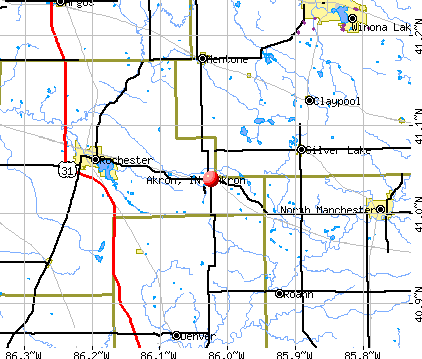
- OSM Map
- General Map
- Google Map
- MSN Map
Population change since 2000: +3.4%
 |
| Males: 537 | |
| Females: 576 |
| Median resident age: | 34.7 years |
| Indiana median age: | 38.2 years |
Zip codes: 46910.
| Akron: | $58,617 |
| IN: | $66,785 |
Estimated per capita income in 2022: $24,244 (it was $14,878 in 2000)
Akron town income, earnings, and wages data
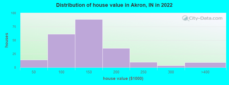
Estimated median house or condo value in 2022: $127,880 (it was $68,800 in 2000)
| Akron: | $127,880 |
| IN: | $208,700 |
Mean prices in 2022: all housing units: $127,096; detached houses: $138,387; mobile homes: $13,061
Median gross rent in 2022: $799.
(12.6% for White Non-Hispanic residents, 22.7% for Hispanic or Latino residents, 26.0% for other race residents)
Detailed information about poverty and poor residents in Akron, IN
Compare current foreclosures near Akron, IN:
| Photo | Address | Area | Beds / Baths | Price | Details |
|---|---|---|---|---|---|

|
#1
E Walnut St
Akron, IN 46910
|
1,610 sq. feet
|
2 baths 4 beds |
show details | |

|
#2
E Walnut St
Akron, IN 46910
|
1,080 sq. feet
|
1 baths 3 beds |
show details | |

|
#3
S 1st St
North Manchester, IN 46962
|
1,281 sq. feet
|
1 baths 2 beds |
$145,000
|
show details |

|
#4
W Oak St
Macy, IN 46951
|
1,352 sq. feet
|
1 baths 3 beds |
show details | |

|
#5
Park St
Rochester, IN 46975
|
1,088 sq. feet
|
1 baths 3 beds |
show details | |

|
#6
N State Road 15
Roann, IN 46974
|
1,304 sq. feet
|
2 baths 3 beds |
show details | |

|
#7
Juniper Rd
Argos, IN 46501
|
1,754 sq. feet
|
1 baths 2 beds |
show details | |

|
#8
Highlander Dr
Warsaw, IN 46580
|
1,433 sq. feet
|
2 baths 3 beds |
show details | |

|
#9
W 100 S
Etna Green, IN 46524
|
1,740 sq. feet
|
2 baths 3 beds |
show details | |

|
#10
Second St
Rochester, IN 46975
|
1,080 sq. feet
|
1 baths 2 beds |
show details |
| Photo | Address | Area | Beds / Baths | Price | Details |
|---|---|---|---|---|---|

|
#11
W 4th St
North Manchester, IN 46962
|
1,317 sq. feet
|
1 baths 4 beds |
show details | |

|
#12
W 4th St
North Manchester, IN 46962
|
1,560 sq. feet
|
1 baths 3 beds |
show details | |

|
#13
W 600 N
Peru, IN 46970
|
2,393 sq. feet
|
1 baths 4 beds |
show details | |

|
#14
E Main St
Warsaw, IN 46580
|
1,800 sq. feet
|
1 baths 3 beds |
show details | |

|
#15
S Half St
North Manchester, IN 46962
|
1,278 sq. feet
|
1 baths 3 beds |
show details | |

|
#16
E Muirfield Rd
Winona Lake, IN 46590
|
2,450 sq. feet
|
3 baths 5 beds |
show details | |

|
#17
N Market St
North Manchester, IN 46962
|
1,574 sq. feet
|
2 baths 3 beds |
show details | |

|
#18
Bond St
North Manchester, IN 46962
|
1,248 sq. feet
|
2 baths 3 beds |
show details | |

|
#19
W 450 N
Rochester, IN 46975
|
1,190 sq. feet
|
1 baths 3 beds |
show details | |

|
#20
State Road 10
Bourbon, IN 46504
|
1,285 sq. feet
|
1 baths 4 beds |
show details |
| Photo | Address | Area | Beds / Baths | Price | Details |
|---|---|---|---|---|---|

|
#21
Henderson Dr
Warsaw, IN 46580
|
1,594 sq. feet
|
1 baths 3 beds |
show details | |

|
#22
N Tower St
Etna Green, IN 46524
|
825 sq. feet
|
1 baths 1 beds |
show details | |

|
#23
W Baker St
Warsaw, IN 46580
|
1,820 sq. feet
|
2 baths 3 beds |
show details | |

|
#24
E Sycamore Dr
Warsaw, IN 46580
|
1,073 sq. feet
|
2 baths 3 beds |
show details | |

|
#25
Crestview Dr
North Manchester, IN 46962
|
1,716 sq. feet
|
1 baths 3 beds |
show details | |

|
#26
S Blue Spruce Rd
Warsaw, IN 46580
|
1,380 sq. feet
|
2 baths 3 beds |
show details | |

|
#27
W Old Road 30
Warsaw, IN 46580
|
1,848 sq. feet
|
2 baths 3 beds |
show details | |

|
#28
N State Road 19
Peru, IN 46970
|
2,856 sq. feet
|
1 baths 5 beds |
show details | |

|
#29
Widaman St
Winona Lake, IN 46590
|
1,936 sq. feet
|
1 baths 3 beds |
show details | |

|
#30
E Center St
Warsaw, IN 46580
|
2,536 sq. feet
|
2 baths 4 beds |
show details |
| Photo | Address | Area | Beds / Baths | Price | Details |
|---|---|---|---|---|---|

|
#31
E 1300 N
North Manchester, IN 46962
|
1,344 sq. feet
|
2 baths 3 beds |
show details | |

|
#32
E County Road 550 N
Peru, IN 46970
|
1,058 sq. feet
|
1 baths 3 beds |
show details | |

|
#33
W Market St
Warsaw, IN 46580
|
976 sq. feet
|
1 baths 2 beds |
show details | |

|
#34
Copeland St
Warsaw, IN 46580
|
1,328 sq. feet
|
2 baths 3 beds |
show details | |

|
#35
S 275 E
Warsaw, IN 46580
|
1,970 sq. feet
|
2 baths 5 beds |
show details | |

|
#36
Cedar Rd
Tippecanoe, IN 46570
|
1,184 sq. feet
|
1 baths 3 beds |
show details | |

|
#37
Maple Rd
Argos, IN 46501
|
1,040 sq. feet
|
1 baths 2 beds |
show details | |

|
#38
E Olson Rd
Rochester, IN 46975
|
1,896 sq. feet
|
2 baths 4 beds |
show details | |

|
#39
W 3rd St
Rochester, IN 46975
|
1,502 sq. feet
|
1 baths 2 beds |
show details | |

|
#40
E State Road 110
Rochester, IN 46975
|
1,568 sq. feet
|
2 baths 3 beds |
show details |
| Photo | Address | Area | Beds / Baths | Price | Details |
|---|---|---|---|---|---|

|
#41
S Bouse Dr
Silver Lake, IN 46982
|
1,064 sq. feet
|
1 baths 2 beds |
show details | |

|
#42
W 5th St
Rochester, IN 46975
|
1,536 sq. feet
|
1 baths 2 beds |
show details | |

|
#43
State Road 331
Tippecanoe, IN 46570
|
1,248 sq. feet
|
1 baths 3 beds |
show details | |

|
#44
College Ave
Rochester, IN 46975
|
1,080 sq. feet
|
1 baths 3 beds |
show details | |

|
#45
S Schoolview Dr
Rochester, IN 46975
|
1,148 sq. feet
|
1 baths 3 beds |
show details | |

|
#46
E 200 N
Rochester, IN 46975
|
2,114 sq. feet
|
2 baths 4 beds |
show details | |

|
#47
Pontiac St
Rochester, IN 46975
|
2,048 sq. feet
|
2 baths 3 beds |
show details | |

|
#48
S 325 E
Macy, IN 46951
|
1,606 sq. feet
|
2 baths 2 beds |
show details | |

|
#49
20th Rd
Tippecanoe, IN 46570
|
1,296 sq. feet
|
2 baths - beds |
show details | |

|
Check over 1 million property listings on Foreclosure.com!
|
browse all offers | |||


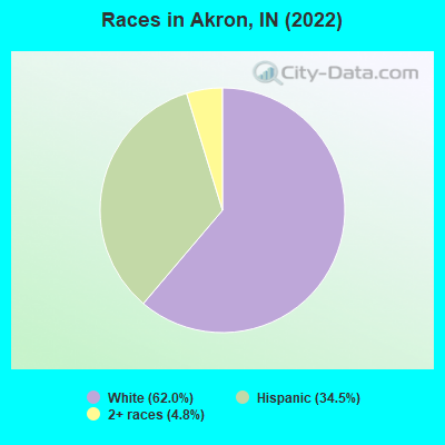
- 66362.0%White alone
- 36934.5%Hispanic
- 514.8%Two or more races
Races in Akron detailed stats: ancestries, foreign born residents, place of birth
 Recent articles from our blog. Our writers, many of them Ph.D. graduates or candidates, create easy-to-read articles on a wide variety of topics.


 | Someone please talk to me about Muncie. (22 replies) |
| Why is Indiana considered " backwards " ? (135 replies) |
| Bloomington Indiana shrinks, new Census (15 replies) |
| Cabela's, Bass Pro Shops and IKEA (91 replies) |
| Unhappy in Indiana (190 replies) |
| Does Indianapolis Have A Quality Downtown? (174 replies) |
Latest news from Akron, IN collected exclusively by city-data.com from local newspapers, TV, and radio stations
Ancestries: American (11.7%), English (10.8%), German (9.7%), Irish (2.6%), European (1.4%), Dutch (1.1%).
Current Local Time: EST time zone
Elevation: 859 feet
Land area: 0.45 square miles.
Population density: 2,447 people per square mile (low).
165 residents are foreign born (14.2% Latin America).
| This town: | 15.4% |
| Indiana: | 5.6% |
Median real estate property taxes paid for housing units with mortgages in 2022: $776 (0.6%)
Median real estate property taxes paid for housing units with no mortgage in 2022: $546 (0.4%)
Nearest city with pop. 50,000+: Elkhart, IN  (44.7 miles , pop. 51,874).
Nearest city with pop. 200,000+: Fort Wayne, IN (46.9 miles , pop. 205,727).
Nearest city with pop. 1,000,000+: Chicago, IL (102.2 miles , pop. 2,896,016).
Nearest cities:
), )Latitude: 41.04 N, Longitude: 86.02 W
Area code: 574
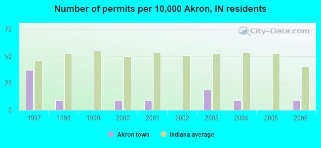
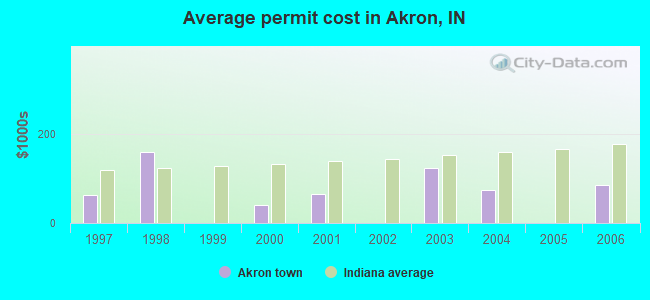
Single-family new house construction building permits:
- 2006: 1 building, cost: $85,000
- 2004: 1 building, cost: $75,000
- 2003: 2 buildings, average cost: $122,900
- 2001: 1 building, cost: $66,000
- 2000: 1 building, cost: $40,000
- 1998: 1 building, cost: $160,000
- 1997: 4 buildings, average cost: $62,500
| Here: | 3.3% |
| Indiana: | 2.8% |
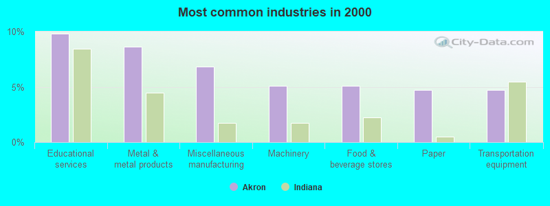
- Educational services (9.8%)
- Metal & metal products (8.6%)
- Miscellaneous manufacturing (6.8%)
- Machinery (5.1%)
- Food & beverage stores (5.1%)
- Paper (4.7%)
- Transportation equipment (4.7%)
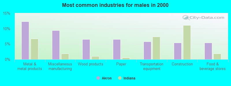
- Metal & metal products (12.3%)
- Miscellaneous manufacturing (9.4%)
- Wood products (6.5%)
- Paper (6.5%)
- Transportation equipment (5.8%)
- Construction (5.4%)
- Food & beverage stores (5.4%)
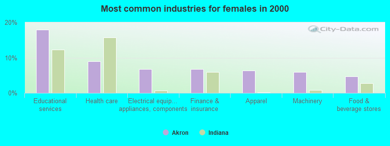
- Educational services (17.9%)
- Health care (8.9%)
- Electrical equipment, appliances, components (6.8%)
- Finance & insurance (6.8%)
- Apparel (6.4%)
- Machinery (6.0%)
- Food & beverage stores (4.7%)
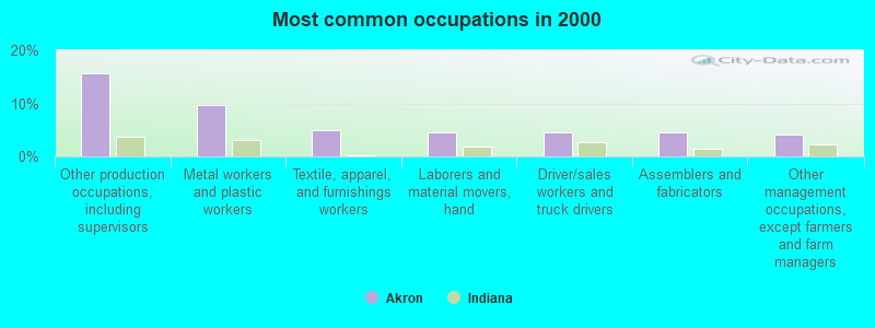
- Other production occupations, including supervisors (15.7%)
- Metal workers and plastic workers (9.6%)
- Textile, apparel, and furnishings workers (4.9%)
- Laborers and material movers, hand (4.5%)
- Driver/sales workers and truck drivers (4.5%)
- Assemblers and fabricators (4.5%)
- Other management occupations, except farmers and farm managers (4.1%)
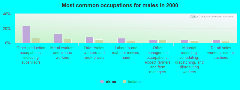
- Other production occupations, including supervisors (23.6%)
- Metal workers and plastic workers (12.7%)
- Driver/sales workers and truck drivers (8.3%)
- Laborers and material movers, hand (6.5%)
- Other management occupations, except farmers and farm managers (4.3%)
- Material recording, scheduling, dispatching, and distributing workers (4.3%)
- Retail sales workers, except cashiers (4.0%)

- Textile, apparel, and furnishings workers (7.7%)
- Preschool, kindergarten, elementary, and middle school teachers (6.8%)
- Cashiers (6.4%)
- Other production occupations, including supervisors (6.4%)
- Metal workers and plastic workers (6.0%)
- Financial clerks, except bookkeeping, accounting and auditing clerks (5.1%)
- Assemblers and fabricators (5.1%)
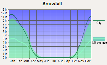
Average climate in Akron, Indiana
Based on data reported by over 4,000 weather stations


|
|


(lower is better)
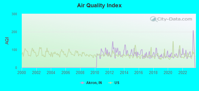
Air Quality Index (AQI) level in 2023 was 101. This is worse than average.
| City: | 101 |
| U.S.: | 73 |
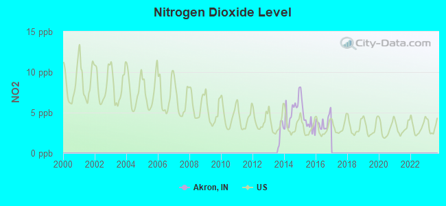
Nitrogen Dioxide (NO2) [ppb] level in 2016 was 3.82. This is better than average. Closest monitor was 22.5 miles away from the city center.
| City: | 3.82 |
| U.S.: | 5.11 |
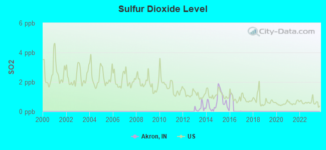
Sulfur Dioxide (SO2) [ppb] level in 2016 was 0.373. This is significantly better than average. Closest monitor was 22.5 miles away from the city center.
| City: | 0.373 |
| U.S.: | 1.515 |
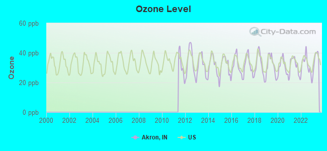
Ozone [ppb] level in 2023 was 35.3. This is about average. Closest monitor was 23.9 miles away from the city center.
| City: | 35.3 |
| U.S.: | 33.3 |
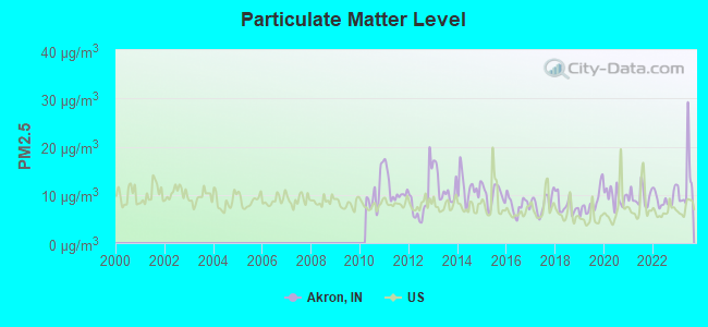
Particulate Matter (PM2.5) [µg/m3] level in 2023 was 12.6. This is significantly worse than average. Closest monitor was 22.5 miles away from the city center.
| City: | 12.6 |
| U.S.: | 8.1 |
Tornado activity:
Akron-area historical tornado activity is near Indiana state average. It is 93% greater than the overall U.S. average.
On 4/3/1956, a category F3 (max. wind speeds 158-206 mph) tornado 5.0 miles away from the Akron town center caused between $5000 and $50,000 in damages.
On 4/11/1965, a category F4 (max. wind speeds 207-260 mph) tornado 33.4 miles away from the town center killed 31 people and injured 252 people.
Earthquake activity:
Akron-area historical earthquake activity is significantly above Indiana state average. It is 20% greater than the overall U.S. average.On 4/18/2008 at 09:36:59, a magnitude 5.4 (5.1 MB, 4.8 MS, 5.4 MW, 5.2 MW, Class: Moderate, Intensity: VI - VII) earthquake occurred 204.5 miles away from the city center
On 6/10/1987 at 23:48:54, a magnitude 5.1 (4.9 MB, 4.4 MS, 4.6 MS, 5.1 LG) earthquake occurred 182.4 miles away from Akron center
On 4/18/2008 at 09:36:59, a magnitude 5.2 (5.2 MW, Depth: 8.9 mi) earthquake occurred 204.5 miles away from the city center
On 7/27/1980 at 18:52:21, a magnitude 5.2 (5.1 MB, 4.7 MS, 5.0 UK, 5.2 UK) earthquake occurred 225.2 miles away from the city center
On 7/12/1986 at 08:19:37, a magnitude 4.5 (4.5 MB, Class: Light, Intensity: IV - V) earthquake occurred 93.3 miles away from Akron center
On 6/18/2002 at 17:37:15, a magnitude 5.0 (4.3 MB, 4.6 MW, 5.0 LG) earthquake occurred 230.9 miles away from the city center
Magnitude types: regional Lg-wave magnitude (LG), body-wave magnitude (MB), surface-wave magnitude (MS), moment magnitude (MW)
Natural disasters:
The number of natural disasters in Fulton County (15) is near the US average (15).Major Disasters (Presidential) Declared: 8
Emergencies Declared: 5
Causes of natural disasters: Floods: 7, Storms: 6, Tornadoes: 4, Winter Storms: 4, Snowstorms: 2, Hurricane: 1, Snow: 1, Other: 1 (Note: some incidents may be assigned to more than one category).

Hospitals and medical centers near Akron:
- HICKORY CREEK AT ROCHESTER (Nursing Home, about 10 miles away; ROCHESTER, IN)
- ROCHESTER NURSING HOME (Nursing Home, about 10 miles away; ROCHESTER, IN)
- TRINITY HEALTHCARE, INC (Home Health Center, about 11 miles away; ROCHESTER, IN)
- HOPE HOSPICE INC (Hospital, about 11 miles away; ROCHESTER, IN)
- LIFE CARE CENTER OF ROCHESTER (Nursing Home, about 11 miles away; ROCHESTER, IN)
- WOODLAWN HOSPITAL Critical Access Hospitals (about 12 miles away; ROCHESTER, IN)
- TIMBERCREST CHURCH OF BRETHREN (Nursing Home, about 14 miles away; NORTH MANCHESTER, IN)
Airports located in Akron:
- Woodcock Airport (II05) (Runways: 1)
Colleges/universities with over 2000 students nearest to Akron:
- Indiana University-Kokomo (about 41 miles; Kokomo, IN; Full-time enrollment: 2,500)
- Indiana Wesleyan University (about 41 miles; Marion, IN; FT enrollment: 13,681)
- University of Saint Francis-Fort Wayne (about 45 miles; Fort Wayne, IN; FT enrollment: 2,075)
- Indiana University-South Bend (about 45 miles; South Bend, IN; FT enrollment: 5,563)
- University of Notre Dame (about 48 miles; Notre Dame, IN; FT enrollment: 12,214)
- Indiana Institute of Technology (about 48 miles; Fort Wayne, IN; FT enrollment: 4,320)
- Indiana University-Purdue University-Fort Wayne (about 48 miles; Fort Wayne, IN; FT enrollment: 10,126)
Public high school in Akron:
- TIPPECANOE VALLEY HIGH SCHOOL (Students: 718, Location: 8345 S SR 19, Grades: 9-12)
Public elementary/middle school in Akron:
- AKRON ELEMENTARY SCHOOL (Students: 468, Location: 202 E RURAL ST, Grades: KG-5)
Points of interest:
Notable location: Henry Township Fire Department (A). Display/hide its location on the map
Hotel: North Ave Motel (110 West North Av).
Drinking water stations with addresses in Akron and their reported violations in the past:
AKRON WATER DEPARTMENT (Population served: 1,167, Groundwater):Past monitoring violations:
- Initial, Follow-up, or Routine Source Water M/R - In JAN-01-2001, Contaminant: Lead and Copper Rule. Follow-up actions: St Violation/Reminder Notice (APR-20-2001), St Compliance achieved (MAR-09-2006)
- 2 routine major monitoring violations
| This town: | 2.8 people |
| Indiana: | 2.5 people |
| This town: | 72.0% |
| Whole state: | 66.9% |
| This town: | 6.8% |
| Whole state: | 6.9% |
Likely homosexual households (counted as self-reported same-sex unmarried-partner households)
- Lesbian couples: 0.5% of all households
- Gay men: 0.5% of all households
Banks with branches in Akron (2011 data):
- Lake City Bank: Akron Branch at 102 East Rochester Street, branch established on 1990/10/03. Info updated 2006/05/11: Bank assets: $2,885.4 mil, Deposits: $2,413.2 mil, headquarters in Warsaw, IN, positive income, Commercial Lending Specialization, 45 total offices, Holding Company: Lakeland Financial Corporation
- Wells Fargo Bank, National Association: Akron Branch at 114 West Rochester Street, branch established on 1866/01/01. Info updated 2011/04/05: Bank assets: $1,161,490.0 mil, Deposits: $905,653.0 mil, headquarters in Sioux Falls, SD, positive income, 6395 total offices, Holding Company: Wells Fargo & Company
For population 15 years and over in Akron:
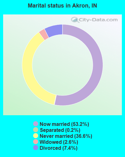
- Never married: 36.6%
- Now married: 53.2%
- Separated: 0.2%
- Widowed: 2.6%
- Divorced: 7.4%
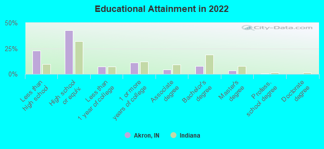
For population 25 years and over in Akron:
- High school or higher: 75.8%
- Bachelor's degree or higher: 10.9%
- Graduate or professional degree: 4.0%
- Unemployed: 2.7%
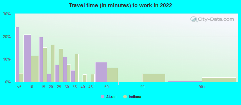
- Mean travel time to work (commute): 21.8 minutes
| Here: | 12.2 |
| Indiana average: | 11.3 |

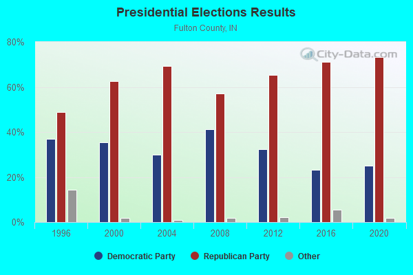
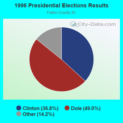
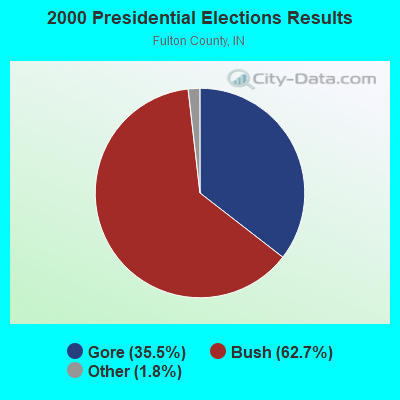
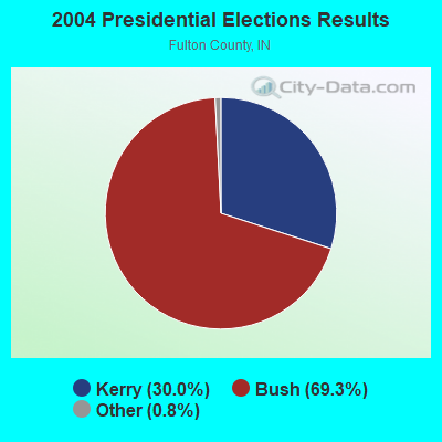
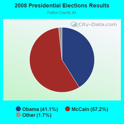

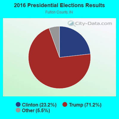
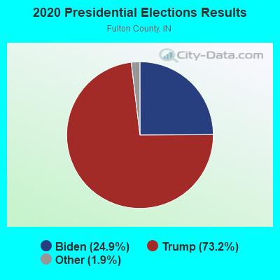
Graphs represent county-level data. Detailed 2008 Election Results
Religion statistics for Akron, IN (based on Fulton County data)
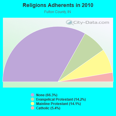
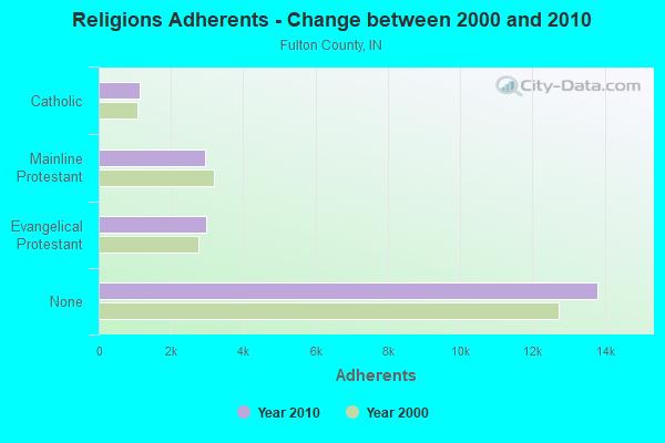
| Religion | Adherents | Congregations |
|---|---|---|
| Evangelical Protestant | 2,958 | 27 |
| Mainline Protestant | 2,942 | 18 |
| Catholic | 1,128 | 2 |
| Other | 1 | 1 |
| None | 13,807 | - |
Food Environment Statistics:
| Fulton County: | 2.96 / 10,000 pop. |
| Indiana: | 1.73 / 10,000 pop. |
| Fulton County: | 1.97 / 10,000 pop. |
| State: | 3.57 / 10,000 pop. |
| Here: | 11.85 / 10,000 pop. |
| State: | 6.78 / 10,000 pop. |
| This county: | 10.2% |
| Indiana: | 9.2% |
| Fulton County: | 28.4% |
| Indiana: | 29.0% |
| This county: | 19.9% |
| State: | 14.3% |
Health and Nutrition:
| Here: | 46.5% |
| Indiana: | 49.3% |
| This city: | 42.8% |
| State: | 46.2% |
| Akron: | 28.5 |
| Indiana: | 28.7 |
| Akron: | 22.3% |
| State: | 21.3% |
| Here: | 11.5% |
| Indiana: | 10.6% |
| This city: | 6.8 |
| Indiana: | 6.8 |
| Akron: | 31.5% |
| Indiana: | 33.9% |
| Akron: | 53.2% |
| Indiana: | 56.1% |
| Akron: | 77.0% |
| State: | 78.7% |
More about Health and Nutrition of Akron, IN Residents
| Local government employment and payroll (March 2022) | |||||
| Function | Full-time employees | Monthly full-time payroll | Average yearly full-time wage | Part-time employees | Monthly part-time payroll |
|---|---|---|---|---|---|
| Water Supply | 2 | $7,185 | $43,110 | 2 | $2,982 |
| Police Protection - Officers | 1 | $5,723 | $68,676 | 0 | $0 |
| Other Government Administration | 1 | $3,543 | $42,516 | 3 | $1,019 |
| Financial Administration | 0 | $0 | 1 | $1,674 | |
| Totals for Government | 4 | $16,452 | $49,356 | 6 | $5,675 |
Akron government finances - Expenditure in 2017 (per resident):
- Construction - Sewerage: $2,000 ($1.80)
- Current Operations - Central Staff Services: $227,000 ($203.95)
Water Utilities: $181,000 ($162.62)
Sewerage: $149,000 ($133.87)
Solid Waste Management: $13,000 ($11.68)
Parks and Recreation: $11,000 ($9.88)
- General - Interest on Debt: $62,000 ($55.71)
- Other Capital Outlay - Sewerage: $19,000 ($17.07)
Regular Highways: $3,000 ($2.70)
Central Staff Services: $1,000 ($0.90)
Akron government finances - Revenue in 2017 (per resident):
- Charges - Sewerage: $391,000 ($351.30)
Solid Waste Management: $15,000 ($13.48)
Parks and Recreation: $1,000 ($0.90)
- Local Intergovernmental - Highways: $4,000 ($3.59)
- Miscellaneous - Donations From Private Sources: $17,000 ($15.27)
General Revenue - Other: $6,000 ($5.39)
Rents: $5,000 ($4.49)
Fines and Forfeits: $4,000 ($3.59)
- Revenue - Water Utilities: $376,000 ($337.83)
- State Intergovernmental - Other: $100,000 ($89.85)
Highways: $89,000 ($79.96)
General Local Government Support: $82,000 ($73.67)
- Tax - Property: $186,000 ($167.12)
Other License: $1,000 ($0.90)
Akron government finances - Debt in 2017 (per resident):
- Long Term Debt - Beginning Outstanding - Unspecified Public Purpose: $1,430,000 ($1284.82)
Outstanding Unspecified Public Purpose: $1,430,000 ($1284.82)
Akron government finances - Cash and Securities in 2017 (per resident):
- Bond Funds - Cash and Securities: $67,000 ($60.20)
- Other Funds - Cash and Securities: $959,000 ($861.64)
- Sinking Funds - Cash and Securities: $325,000 ($292.00)
Businesses in Akron, IN
- Jones New York: 1
Strongest AM radio stations in Akron:
- WOWO (1190 AM; 50 kW; FORT WAYNE, IN; Owner: PATHFINDER COMMUNICATIONS CORPORATION)
- WIBC (1070 AM; 50 kW; INDIANAPOLIS, IN; Owner: EMMIS RADIO LICENSE CORPORATION)
- WLS (890 AM; 50 kW; CHICAGO, IL; Owner: WLS, INC.)
- WSCR (670 AM; 50 kW; CHICAGO, IL; Owner: INFINITY BROADCASTING OPERATIONS, INC.)
- WGN (720 AM; 50 kW; CHICAGO, IL; Owner: WGN CONTINENTAL BROADCASTING CO.)
- WBBM (780 AM; 50 kW; CHICAGO, IL; Owner: INFINITY BROADCASTING OPERATIONS, INC.)
- WMVP (1000 AM; 50 kW; CHICAGO, IL; Owner: ABC, INC.)
- WYLL (1160 AM; 50 kW; CHICAGO, IL; Owner: SCA LICENSE CORPORATION)
- WDND (1620 AM; 10 kW; SOUTH BEND, IN; Owner: ARTISTIC MEDIA PARTNERS, INC.)
- WHLY (1580 AM; 10 kW; SOUTH BEND, IN; Owner: TIMES COMMUNICATIONS INC.)
- WLW (700 AM; 50 kW; CINCINNATI, OH; Owner: JACOR BROADCASTING CORPORATION)
- WTMJ (620 AM; 50 kW; MILWAUKEE, WI; Owner: JOURNAL BROADCAST CORPORATION)
- WSBT (960 AM; 5 kW; SOUTH BEND, IN; Owner: WSBT, INC.)
Strongest FM radio stations in Akron:
- WARU-FM (101.9 FM; ROANN, IN; Owner: MID-AMERICA RADIO GROUP, INC.)
- WLZQ (101.1 FM; SOUTH WHITLEY, IN; Owner: LARKO COMMUNICATIONS INC)
- WKUZ (95.9 FM; WABASH, IN; Owner: UPPER WABASH BROADCASTING CORP.)
- WROI (92.1 FM; ROCHESTER, IN; Owner: BAIR COMMUNICATIONS, INC.)
- WNSN (101.5 FM; SOUTH BEND, IN; Owner: WSBT, INC.)
- WMYK (98.5 FM; PERU, IN; Owner: MIAMI COUNTY BROADCASTING, INC.)
- WBYT (100.7 FM; ELKHART, IN; Owner: PATHFINDER COMMUNICATIONS CORPORATION)
- WNDV-FM (92.9 FM; SOUTH BEND, IN; Owner: ARTISTIC MEDIA PARTNERS, INC.)
- WHPZ (96.9 FM; BREMEN, IN; Owner: LESEA BROADCASTING CORPORATION)
- WLRX (95.7 FM; NAPPANEE, IN; Owner: TALKING STICK COMMUNICATIONS, LLC)
- WJOT-FM (105.9 FM; WABASH, IN; Owner: MID-AMERICA RADIO OF WABASH, INC.)
- WRSW-FM (107.3 FM; WARSAW, IN; Owner: GBC MEDIA, L.L.C.)
- WHZR (103.7 FM; ROYAL CENTER, IN; Owner: MID-AMERICA RADIO GROUP OF)
- WFRI (100.1 FM; WINAMAC, IN; Owner: PROGRESSIVE BROADCASTING SYSTEM, INC)
TV broadcast stations around Akron:
- WMWB-LP (Channel 25; SOUTH BEND, IN; Owner: WMWB-TV LIMITED PARTNERSHIP)
- WNDU-TV (Channel 16; SOUTH BEND, IN; Owner: MICHIANA TELECASTING CORP.)
- WNIT (Channel 34; SOUTH BEND, IN; Owner: MICHIANA PUBLIC BROADCASTING CORPORATION)
- WSJV (Channel 28; ELKHART, IN; Owner: WSJV TELEVISION, INC.)
- WHME-TV (Channel 46; SOUTH BEND, IN; Owner: LESEA BROADCASTING CORPORATION)
- WSBT-TV (Channel 22; SOUTH BEND, IN; Owner: WSBT, INC.)
Akron fatal accident list:
Oct 9, 2019 06:20 PM, Sr-114w, Lat: 41.013081, Lon: -85.956806, Vehicles: 1, Persons: 1, Fatalities: 1
Oct 4, 2012 05:00 PM, Sr-19, Division Rd, Lat: 41.056272, Lon: -86.028094, Vehicles: 2, Persons: 4, Fatalities: 1
May 31, 2008 04:12 PM, Sr-19, Division Rd, Lat: 41.056190, Lon: -86.028360, Vehicles: 2, Persons: 10, Fatalities: 1
Nov 12, 2006 06:30 AM, Sr- 14, Divison Rd, Lat: 41.053180, Lon: -86.116310, Vehicles: 1, Persons: 1, Fatalities: 1, Drunk persons involved: 1
- National Bridge Inventory (NBI) Statistics
- 2Number of bridges
- 33ft / 10.4mTotal length
- 25,532Total average daily traffic
- 1,442Total average daily truck traffic
- 29,243Total future (year 2030) average daily traffic
FCC Registered Cell Phone Towers:
1- 518 East Main, Plaza B (110606) (Lat: 41.035278 Lon: -86.024167), Type: Tank, Structure height: 39.6 m, Overall height: 45.1 m, Call Sign: KNKN509
Assigned Frequencies: 869.040 MHz, 869.040 MHz, 869.040 MHz, 824.040 MHz, 824.040 MHz, 824.040 MHz, 890.010 MHz, 890.010 MHz, 890.010 MHz, 845.010 MHz, 845.010 MHz, 845.010 MHzGrant Date: 09/01/2020, Expiration Date: 10/01/2030, Certifier: Michael P GogginRegistrant: At&t Services, Inc., 208 S Akard St, 20f, Dallas, TX 75202, Phone: (855) 699-7073, Fax: (214) 746-6410, Email:
FCC Registered Broadcast Land Mobile Towers:
5- S Virgil Old Water Tank (Lat: 41.035611 Lon: -86.023056), Type: Tank, Structure height: 30 m, Call Sign: WPMK784,
Assigned Frequencies: 451.225 MHz, Grant Date: 07/12/2023, Expiration Date: 08/23/2033, Certifier: Martin Gearhart, Registrant: J&k Communications, Inc., 222 Towerview Drive, Columbia City, IN 46725, Phone: (260) 244-7975, Fax: (260) 244-3253, Email:
- 300 S Front St And Sr 19 (Lat: 41.034222 Lon: -86.025556), Call Sign: WNDQ629,
Assigned Frequencies: 173.396 MHz, Grant Date: 09/27/2005, Expiration Date: 10/11/2015, Cancellation Date: 08/07/2015, Registrant: Northern Indiana Public Service Company, 1261 Dakota Street, Gary, IN 46403, Phone: (219) 938-7573, Fax: (219) 938-7576, Email:
- Lat: 41.109722 Lon: -86.039167, Call Sign: WQYX377,
Assigned Frequencies: 72.1000 MHz, 72.1400 MHz, Grant Date: 02/21/2017, Expiration Date: 02/21/2027, Certifier: Facility Manager, Registrant: Primex Wireless Inc, 965 Wells St., Lake Geneva, WI 53147, Phone: (262) 729-4858, Email:
- Lat: 41.113361 Lon: -86.061639, Call Sign: WREA271,
Assigned Frequencies: 452.000 MHz, 452.018 MHz, 457.000 MHz, 457.018 MHz, 457.731 MHz, Grant Date: 08/31/2019, Expiration Date: 08/31/2029, Certifier: Harlan Zimmerman, Registrant: J&k Communications, Inc., 222 Towerview Drive, Columbia City, IN 46725, Phone: (260) 244-7975, Fax: (260) 244-3253, Email:
- Henry Twp Fire Dept, Lat: 41.039083 Lon: -86.029306, Call Sign: WRJG469,
Assigned Frequencies: 154.205 MHz, 155.047 MHz, Grant Date: 08/25/2020, Expiration Date: 08/25/2030, Certifier: Brooke Murphy, Registrant: J & K Communications, Inc., 222 South Tower View Drive, Columbia City, IN 46725, Phone: (260) 244-7975, Email:
FCC Registered Microwave Towers:
2- Arkon Tower, Lat: 41.065889 Lon: -86.026917, Type: Ltower, Structure height: 33.5 m, Call Sign: WQML993,
Assigned Frequencies: 3650.00 MHz, Grant Date: 09/21/2010, Expiration Date: 12/01/2019, Cancellation Date: 02/01/2020, Certifier: Roland E Houin Mr., Registrant: Fourway Computer Products, Inc., 51061 S.R. 933 North, South Bend, IN 46637, Phone: (574) 277-7720, Fax: (574) 277-1253, Email:
- MW13090B, 1802 S Town Lake Rd (Lat: 41.027361 Lon: -86.038250), Type: Mtower, Structure height: 54.9 m, Call Sign: WQWI466,
Assigned Frequencies: 6019.32 MHz, 6019.32 MHz, 6019.32 MHz, 6019.32 MHz, 6019.32 MHz, 6019.32 MHz, 6019.32 MHz, 6019.32 MHz, 6019.32 MHz, 6019.32 MHz... (+6 more), Grant Date: 08/31/2015, Expiration Date: 08/31/2025, Certifier: David Werblow, Registrant: T-Mobile License LLC, 12920 Se 38th St, Bellevue, WA 98006, Phone: (425) 383-8401, Fax: (425) 383-4040, Email:
FCC Registered Amateur Radio Licenses:
11 (See the full list of FCC Registered Amateur Radio Licenses in Akron)| Most common first names in Akron, IN among deceased individuals | ||
| Name | Count | Lived (average) |
|---|---|---|
| Mary | 22 | 82.4 years |
| George | 18 | 77.3 years |
| William | 14 | 83.5 years |
| Charles | 13 | 67.5 years |
| Ruth | 12 | 87.0 years |
| Harold | 11 | 71.2 years |
| Robert | 11 | 75.8 years |
| Paul | 11 | 80.8 years |
| Helen | 10 | 77.7 years |
| Margaret | 10 | 78.7 years |
| Most common last names in Akron, IN among deceased individuals | ||
| Last name | Count | Lived (average) |
|---|---|---|
| Smith | 25 | 75.3 years |
| Miller | 22 | 74.7 years |
| White | 9 | 78.6 years |
| Swick | 9 | 87.4 years |
| Whittenberge | 8 | 78.4 years |
| Leininger | 8 | 83.9 years |
| Engle | 7 | 75.4 years |
| Nicodemus | 7 | 79.2 years |
| Merley | 7 | 77.9 years |
| Thompson | 7 | 75.1 years |
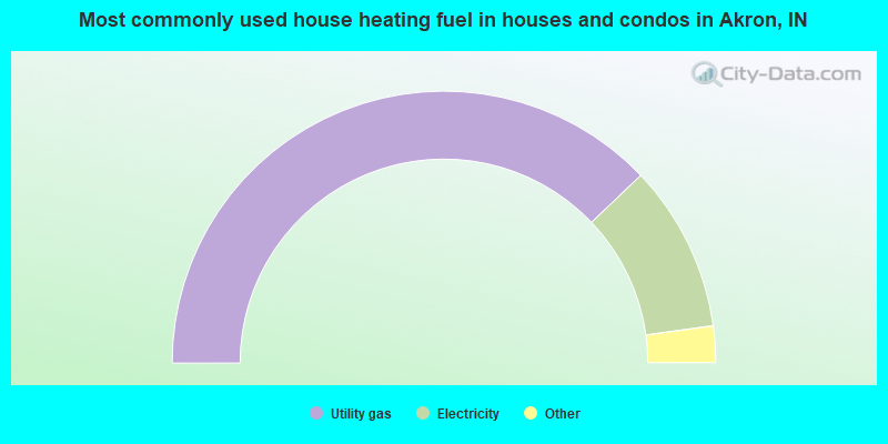
- 76.3%Utility gas
- 20.0%Electricity
- 2.0%Wood
- 1.6%Bottled, tank, or LP gas
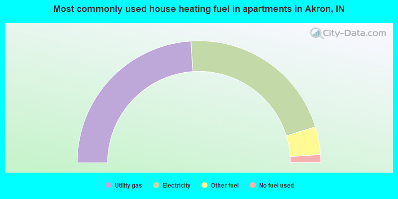
- 47.9%Utility gas
- 42.6%Electricity
- 7.4%Other fuel
- 2.1%No fuel used
Akron compared to Indiana state average:
- Median house value below state average.
- Unemployed percentage significantly below state average.
- Black race population percentage significantly below state average.
- Hispanic race population percentage significantly above state average.
- Median age below state average.
- Foreign-born population percentage significantly above state average.
- Length of stay since moving in above state average.
- House age above state average.
- Percentage of population with a bachelor's degree or higher below state average.

|
|
Total of 14 patent applications in 2008-2024.