Battletown-Payneville, Kentucky
Submit your own pictures of this place and show them to the world
- OSM Map
- Google Map
- MSN Map
| Males: 1,897 | |
| Females: 1,852 |
| Median resident age: | 36.1 years |
| Kentucky median age: | 35.9 years |
Zip code: 40104
| Battletown-Payneville: | $57,625 |
| KY: | $59,341 |
Estimated per capita income in 2022: $32,874 (it was $14,916 in 2000)
Battletown-Payneville CCD income, earnings, and wages data
Estimated median house or condo value in 2022: $167,644 (it was $60,900 in 2000)
| Battletown-Payneville: | $167,644 |
| KY: | $196,300 |
Battletown-Payneville, KY residents, houses, and apartments details
Detailed information about poverty and poor residents in Battletown-Payneville, KY
Compare current foreclosures near your location:
| Photo | Address | Area | Beds / Baths | Price | Details |
|---|---|---|---|---|---|

|
#1
N Rhodes St
Pretty Prairie, KS 67570
|
1,725 sq. feet
|
2 baths 4 beds |
show details | |

|
#2
S Goddard Rd
Goddard, KS 67052
|
1,054 sq. feet
|
2 baths 2 beds |
show details | |

|
#3
W 21st St N
Cheney, KS 67025
|
3,190 sq. feet
|
3 baths 5 beds |
show details | |

|
#4
E Winterset St
Goddard, KS 67052
|
816 sq. feet
|
1 baths 2 beds |
show details | |

|
#5
NE Waterloo Ave
Murdock, KS 67111
|
1,220 sq. feet
|
1 baths 3 beds |
show details | |

|
#6
W 39th St S
Goddard, KS 67052
|
4,221 sq. feet
|
3 baths 3 beds |
show details | |

|
#7
E Arlington Rd
Haven, KS 67543
|
960 sq. feet
|
1 baths 2 beds |
show details | |

|
#8
S 391st St W
Cheney, KS 67025
|
2,558 sq. feet
|
3 baths 3 beds |
show details | |

|
#9
SE Viney Ave
Murdock, KS 67111
|
- sq. feet
|
- baths - beds |
show details | |

|
#10
W Main St
Mount Hope, KS 67108
|
- sq. feet
|
- baths - beds |
show details |
| Photo | Address | Area | Beds / Baths | Price | Details |
|---|---|---|---|---|---|

|
#11
N 189th Cir W
Colwich, KS 67030
|
- sq. feet
|
- baths - beds |
show details | |

|
#12
N Main St
Goddard, KS 67052
|
- sq. feet
|
- baths - beds |
show details | |

|
#13
Martens Ct
Goddard, KS 67052
|
- sq. feet
|
- baths - beds |
show details | |

|
#14
E 4th Ave Apt 1
Cheney, KS 67025
|
- sq. feet
|
- baths - beds |
show details | |

|
#15
W Maple St Lot D
Goddard, KS 67052
|
- sq. feet
|
- baths - beds |
show details | |

|
#16
W 47th St S
Garden Plain, KS 67050
|
- sq. feet
|
- baths - beds |
show details | |

|
#17
S 339th St W
Cheney, KS 67025
|
- sq. feet
|
- baths - beds |
show details | |

|
#18
E Casey Dr
Goddard, KS 67052
|
- sq. feet
|
- baths - beds |
show details | |

|
Check over 1 million property listings on Foreclosure.com!
|
browse all offers | |||

- 3,55397.2%White alone
- 280.8%American Indian alone
- 250.7%Two or more races
- 220.6%Hispanic
- 180.5%Black alone
- 70.2%Asian alone
- 20.05%Other race alone

Races in Battletown-Payneville detailed stats: ancestries, foreign born residents, place of birth
 Recent articles from our blog. Our writers, many of them Ph.D. graduates or candidates, create easy-to-read articles on a wide variety of topics.

Current Local Time: EST time zone
Land area: 125.2 square miles.
Population density: 30 people per square mile (very low).
| Battletown-Payneville CCD: | 0.5% ($284) |
| Kentucky: | 0.8% ($610) |
Nearest city with pop. 50,000+: Louisville, KY  (35.2 miles , pop. 256,231).
Nearest city with pop. 1,000,000+: Chicago, IL (271.1 miles , pop. 2,896,016).
Nearest cities:
), )Latitude: 38.05 N, Longitude: 86.36 W

| Here: | 4.1% |
| Kentucky: | 3.8% |

- Construction (15.5%)
- Educational services (6.3%)
- Food & beverage stores (6.1%)
- Agriculture, forestry, fishing & hunting (5.9%)
- Metal & metal products (5.9%)
- Health care (5.7%)
- Public administration (4.6%)

- Construction (26.2%)
- Metal & metal products (10.3%)
- Agriculture, forestry, fishing & hunting (7.2%)
- Truck transportation (4.6%)
- Public administration (4.0%)
- Food & beverage stores (4.0%)
- Mining, quarrying, oil & gas extraction (3.5%)

- Health care (13.5%)
- Educational services (10.8%)
- Food & beverage stores (9.0%)
- Accommodation & food services (7.1%)
- Public administration (5.4%)
- Agriculture, forestry, fishing & hunting (4.2%)
- Finance & insurance (3.9%)

- Other production occupations, including supervisors (8.7%)
- Driver/sales workers and truck drivers (6.3%)
- Metal workers and plastic workers (4.4%)
- Electrical equipment mechanics and other installation, maintenance, and repair workers, including supervisors (4.2%)
- Assemblers and fabricators (3.7%)
- Other sales and related occupations, including supervisors (3.7%)
- Farmers and farm managers (3.6%)

- Other production occupations, including supervisors (11.8%)
- Driver/sales workers and truck drivers (8.8%)
- Metal workers and plastic workers (7.6%)
- Electrical equipment mechanics and other installation, maintenance, and repair workers, including supervisors (7.3%)
- Construction traders workers except carpenters, electricians, painters, plumbers, and construction laborers (5.7%)
- Construction laborers (4.7%)
- Farmers and farm managers (4.6%)

- Secretaries and administrative assistants (6.0%)
- Cashiers (5.8%)
- Health technologists and technicians (5.5%)
- Other office and administrative support workers, including supervisors (5.5%)
- Other sales and related occupations, including supervisors (5.2%)
- Bookkeeping, accounting, and auditing clerks (4.8%)
- Assemblers and fabricators (4.8%)
Average climate in Battletown-Payneville, Kentucky
Based on data reported by over 4,000 weather stations


(lower is better)

Air Quality Index (AQI) level in 2022 was 75.7. This is about average.
| City: | 75.7 |
| U.S.: | 72.6 |

Carbon Monoxide (CO) [ppm] level in 2001 was 0.440. This is significantly worse than average. Closest monitor was 25.0 miles away from the city center.
| City: | 0.440 |
| U.S.: | 0.251 |

Nitrogen Dioxide (NO2) [ppb] level in 2001 was 13.1. This is significantly worse than average. Closest monitor was 23.9 miles away from the city center.
| City: | 13.1 |
| U.S.: | 5.1 |

Sulfur Dioxide (SO2) [ppb] level in 2004 was 6.92. This is significantly worse than average. Closest monitor was 22.5 miles away from the city center.
| City: | 6.92 |
| U.S.: | 1.51 |

Ozone [ppb] level in 2022 was 28.4. This is about average. Closest monitor was 15.9 miles away from the city center.
| City: | 28.4 |
| U.S.: | 33.3 |

Particulate Matter (PM10) [µg/m3] level in 2018 was 19.3. This is about average. Closest monitor was 22.5 miles away from the city center.
| City: | 19.3 |
| U.S.: | 19.2 |

Particulate Matter (PM2.5) [µg/m3] level in 2022 was 9.87. This is worse than average. Closest monitor was 25.0 miles away from the city center.
| City: | 9.87 |
| U.S.: | 8.11 |
Tornado activity:
Battletown-Payneville-area historical tornado activity is slightly above Kentucky state average. It is 60% greater than the overall U.S. average.
On 4/3/1974, a category F5 (max. wind speeds 261-318 mph) tornado 14.0 miles away from the Battletown-Payneville place center killed 31 people and injured 270 people and caused between $500,000 and $5,000,000 in damages.
On 4/3/1974, a category F5 tornado 21.4 miles away from the place center killed 6 people and injured 86 people and caused between $50,000,000 and $500,000,000 in damages.
Earthquake activity:
Battletown-Payneville-area historical earthquake activity is significantly above Kentucky state average. It is 144% greater than the overall U.S. average.On 4/18/2008 at 09:36:59, a magnitude 5.4 (5.1 MB, 4.8 MS, 5.4 MW, 5.2 MW, Class: Moderate, Intensity: VI - VII) earthquake occurred 87.5 miles away from the city center
On 4/18/2008 at 09:36:59, a magnitude 5.2 (5.2 MW, Depth: 8.9 mi) earthquake occurred 87.5 miles away from Battletown-Payneville center
On 6/10/1987 at 23:48:54, a magnitude 5.1 (4.9 MB, 4.4 MS, 4.6 MS, 5.1 LG) earthquake occurred 98.3 miles away from the city center
On 6/18/2002 at 17:37:15, a magnitude 5.0 (4.3 MB, 4.6 MW, 5.0 LG) earthquake occurred 77.7 miles away from the city center
On 7/27/1980 at 18:52:21, a magnitude 5.2 (5.1 MB, 4.7 MS, 5.0 UK, 5.2 UK) earthquake occurred 131.7 miles away from Battletown-Payneville center
On 4/18/2008 at 15:14:16, a magnitude 4.8 (4.5 MB, 4.8 MW, 4.6 MW, Class: Light, Intensity: IV - V) earthquake occurred 86.0 miles away from the city center
Magnitude types: regional Lg-wave magnitude (LG), body-wave magnitude (MB), surface-wave magnitude (MS), moment magnitude (MW)
Natural disasters:
The number of natural disasters in Meade County (15) is near the US average (15).Major Disasters (Presidential) Declared: 12
Emergencies Declared: 2
Causes of natural disasters: Storms: 8, Floods: 7, Tornadoes: 6, Winter Storms: 3, Winds: 2, Blizzard: 1, Hurricane: 1, Tropical Depression: 1, Other: 1 (Note: some incidents may be assigned to more than one category).
Colleges/universities with over 2000 students nearest to Battletown-Payneville:
- University of Louisville (about 35 miles; Louisville, KY; Full-time enrollment: 16,640)
- Indiana University-Southeast (about 36 miles; New Albany, IN; FT enrollment: 5,050)
- Jefferson Community and Technical College (about 36 miles; Louisville, KY; FT enrollment: 7,950)
- Elizabethtown Community and Technical College (about 37 miles; Elizabethtown, KY; FT enrollment: 3,762)
- Bellarmine University (about 38 miles; Louisville, KY; FT enrollment: 3,180)
- The Southern Baptist Theological Seminary (about 39 miles; Louisville, KY; FT enrollment: 2,360)
- Sullivan University (about 39 miles; Louisville, KY; FT enrollment: 5,129)
Points of interest:
Notable locations in Battletown-Payneville: Peters Landing (A), Stony Point (B), Mint Springs (C), Payneville Fire Department (D), Battletown Fire Department (E), Wolf Creek Fire Department (F), Rhodelia Fire Department (G). Display/hide their locations on the map
Churches in Battletown-Payneville include: New Highland Church (A), Blue River Island (B), General Church (C). Display/hide their locations on the map
Cemeteries: Thacker Cemetery (1), Chism Cemetery (2), Richardson Cemetery (3), Owens Cemetery (4), Barr Cemetery (5), Bell Knob Cemetery (6), Bennett Cemetery (7). Display/hide their locations on the map
Streams, rivers, and creeks: Dry Fork (A), Watson Run (B), Wolf Creek (C), Spring Creek (D), French Creek (E). Display/hide their locations on the map
Park in Battletown-Payneville: Lawson Park (1). Display/hide its location on the map
| This place: | 2.6 people |
| Kentucky: | 2.5 people |
| This place: | 74.0% |
| Whole state: | 66.9% |
| This place: | 7.2% |
| Whole state: | 6.4% |
Likely homosexual households (counted as self-reported same-sex unmarried-partner households)
- Lesbian couples: 0.3% of all households
- Gay men: 0.2% of all households
| This place: | 15.3% |
| Whole state: | 15.8% |
| This place: | 4.0% |
| Whole state: | 6.6% |
For population 15 years and over in Battletown-Payneville:

- Never married: 23.1%
- Now married: 59.8%
- Separated: 1.7%
- Widowed: 7.5%
- Divorced: 9.6%
For population 25 years and over in Battletown-Payneville:
- High school or higher: 73.3%
- Bachelor's degree or higher: 4.7%
- Graduate or professional degree: 1.7%
- Unemployed: 6.0%
- Mean travel time to work (commute): 38.2 minutes


| Here: | 9.6 |
| Kentucky average: | 13.8 |
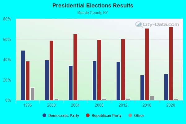
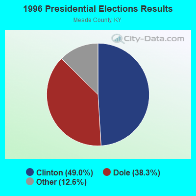
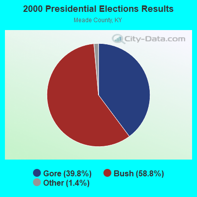
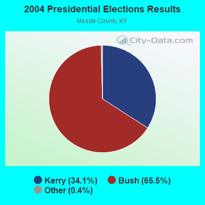
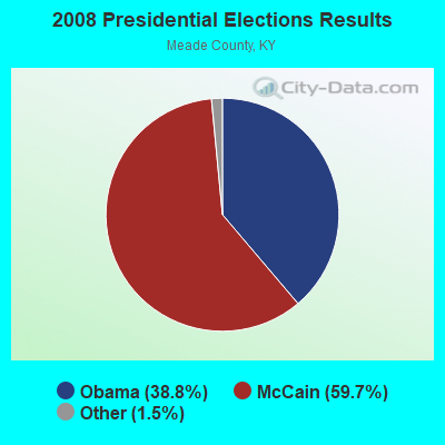
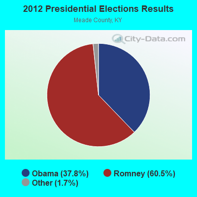
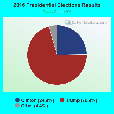
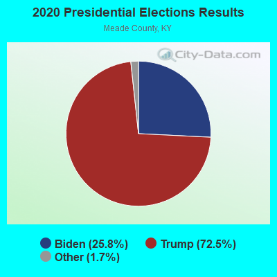
Graphs represent county-level data. Detailed 2008 Election Results
Religion statistics for Battletown-Payneville, KY (based on Meade County data)
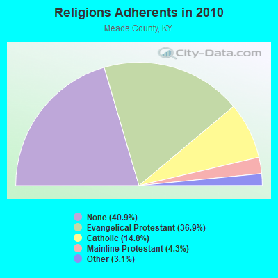
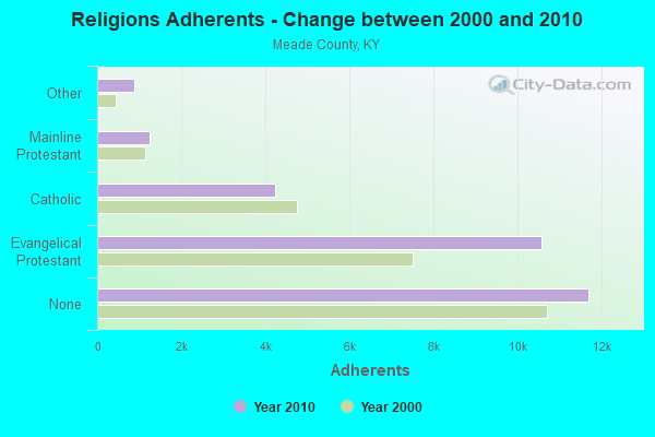
| Religion | Adherents | Congregations |
|---|---|---|
| Evangelical Protestant | 10,566 | 29 |
| Catholic | 4,227 | 4 |
| Mainline Protestant | 1,244 | 5 |
| Other | 877 | 1 |
| None | 11,688 | - |
Food Environment Statistics:
| Meade County: | 1.10 / 10,000 pop. |
| Kentucky: | 2.19 / 10,000 pop. |
| Meade County: | 0.37 / 10,000 pop. |
| Kentucky: | 0.74 / 10,000 pop. |
| Meade County: | 5.51 / 10,000 pop. |
| State: | 4.36 / 10,000 pop. |
| Here: | 2.57 / 10,000 pop. |
| State: | 5.74 / 10,000 pop. |
| This county: | 11.1% |
| Kentucky: | 11.0% |
| Meade County: | 33.0% |
| Kentucky: | 30.0% |
| This county: | 13.5% |
| State: | 15.9% |
10.89% of this county's 2021 resident taxpayers lived in other counties in 2020 ($55,543 average adjusted gross income)
| Here: | 10.89% |
| Kentucky average: | 7.04% |
0.34% of residents moved from foreign countries ($2,243 average AGI)
Meade County: 0.34% Kentucky average: 0.02%
Top counties from which taxpayers relocated into this county between 2020 and 2021:
| from Hardin County, KY | |
| from Jefferson County, KY | |
| from Breckinridge County, KY |
10.44% of this county's 2020 resident taxpayers moved to other counties in 2021 ($52,951 average adjusted gross income)
| Here: | 10.44% |
| Kentucky average: | 6.89% |
0.22% of residents moved to foreign countries ($1,551 average AGI)
Meade County: 0.22% Kentucky average: 0.01%
Top counties to which taxpayers relocated from this county between 2020 and 2021:
| to Hardin County, KY | |
| to Jefferson County, KY | |
| to Breckinridge County, KY |
Strongest AM radio stations in Battletown-Payneville:
- WHAS (840 AM; 50 kW; LOUISVILLE, KY; Owner: CLEAR CHANNEL BROADCASTING LICENSES, INC.)
- WKJK (1080 AM; 10 kW; LOUISVILLE, KY; Owner: CLEAR CHANNEL BROADCASTING LICENSES, INC.)
- WKCM (1160 AM; 2 kW; HAWESVILLE, KY; Owner: HANCOCK COMMUNICATIONS, INC.)
- WGTK (970 AM; 5 kW; LOUISVILLE, KY; Owner: SALEM MEDIA OF KENTUCKY, INC.)
- WSM (650 AM; 50 kW; NASHVILLE, TN; Owner: GAYLORD ENTERTAINMENT COMPANY)
- WLW (700 AM; 50 kW; CINCINNATI, OH; Owner: JACOR BROADCASTING CORPORATION)
- WXXA (790 AM; 5 kW; LOUISVILLE, KY)
- WIBC (1070 AM; 50 kW; INDIANAPOLIS, IN; Owner: EMMIS RADIO LICENSE CORPORATION)
- WAMB (1160 AM; 50 kW; DONELSON, TN; Owner: GREAT SOUTHERN BROADCASTING COMPANY, INC.)
- WKDA (1200 AM; 50 kW; NASHVILLE, TN; Owner: RADIO NASHVILLE, INC.)
- WSAI (1530 AM; 50 kW; CINCINNATI, OH; Owner: JACOR BROADCASTING CORPORATION)
- WSLM (1220 AM; 5 kW; SALEM, IN; Owner: DON H. MARTIN)
- WNQM (1300 AM; 50 kW; NASHVILLE, TN; Owner: WNQM. INC.)
Strongest FM radio stations in Battletown-Payneville:
- WULF (94.3 FM; HARDINSBURG, KY; Owner: SKYTOWER COMMUNICATIONS - 94.3, LLC)
- WMMG-FM (93.5 FM; BRANDENBURG, KY; Owner: MEADE COUNTY COMMUNICATIONS, INC.)
- WRVI (105.9 FM; VALLEY STATION, KY; Owner: SALEM MEDIA OF KENTUCKY, INC.)
- WQMF (95.7 FM; JEFFERSONVILLE, IN; Owner: CLEAR CHANNEL BROADCASTING LICENSES, INC.)
- WASE (103.5 FM; RADCLIFF, KY; Owner: W & B BROADCASTING, INC.)
- WSFR (107.7 FM; CORYDON, IN; Owner: CXR HOLDINGS, INC.)
- WLME (102.9 FM; CANNELTON, IN; Owner: HANCOCK COMMUNICATIONS, INC)
- WXBC (104.3 FM; HARDINSBURG, KY; Owner: BRECKINRIDGE BROADCASTING CO., INC.)
- WFPL (89.3 FM; LOUISVILLE, KY; Owner: KENTUCKY PUBLIC RADIO, INC.)
- WFPK (91.9 FM; LOUISVILLE, KY; Owner: KENTUCKY PUBLIC RADIO, INC.)
- WUOL-FM (90.5 FM; LOUISVILLE, KY; Owner: KENTUCKY PUBLIC RADIO, INC.)
- WJIE-FM (88.5 FM; OKOLONA, KY; Owner: EVANGEL SCHOOLS, INC.)
- WDJX (99.7 FM; LOUISVILLE, KY; Owner: BLUE CHIP BROADCASTING LICENSES II, LTD.)
- WAMZ (97.5 FM; LOUISVILLE, KY; Owner: CLEAR CHANNEL BROADCASTING LICENSES, INC.)
- W284AD (104.7 FM; NEW ALBANY, IN; Owner: LIFETALK RADIO, INC.)
- WKUE (90.9 FM; ELIZABETHTOWN, KY; Owner: WESTERN KENTUCKY UNIVERSITY)
- WVEZ (106.9 FM; LOUISVILLE, KY; Owner: CXR HOLDINGS, INC.)
- WQXE (98.3 FM; ELIZABETHTOWN, KY; Owner: SKYTOWER COMMUNICATIONS-E'TOWN, INC.)
- WZKF (98.9 FM; SALEM, IN; Owner: CLEAR CHANNEL BROADCASTING LICENSES, INC.)
- WQKZ (98.5 FM; FERDINAND, IN; Owner: GEM COMMUNICATIONS LLP)
TV broadcast stations around Battletown-Payneville:
- W24BW (Channel 24; LOUISVILLE, KY; Owner: GREATER LOUISVILLE COMMUNICATIONS)
- WHAS-TV (Channel 11; LOUISVILLE, KY; Owner: BELO KENTUCKY, INC.)
- WAVE (Channel 3; LOUISVILLE, KY; Owner: LIBCO, INC.)
- WBKI-CA (Channel 28; LOUISVILLE, KY; Owner: LOUISVILLE COMMUNICATIONS, LLC)
- WDRB (Channel 41; LOUISVILLE, KY; Owner: INDEPENDENCE TELEVISION COMPANY)
- WFTE (Channel 58; SALEM, IN; Owner: INDEPENDENCE TELEVISION COMPANY)
- WLKY-TV (Channel 32; LOUISVILLE, KY; Owner: WLKY HEARST-ARGYLE TELEVISION, INC.)
- WJYL-CA (Channel 45; CLARKSVILLE, IN; Owner: JOHN W. SMITH, JR.)

- 34.1%Electricity
- 30.5%Bottled, tank, or LP gas
- 30.2%Wood
- 4.8%Fuel oil, kerosene, etc.
- 0.4%Utility gas

- 44.2%Bottled, tank, or LP gas
- 37.8%Electricity
- 17.9%Wood
Battletown-Payneville compared to Kentucky state average:
- Unemployed percentage below state average.
- Black race population percentage significantly below state average.
- Hispanic race population percentage significantly below state average.
- Median age below state average.
- Foreign-born population percentage significantly below state average.
- Renting percentage below state average.
- Length of stay since moving in significantly above state average.
- Number of rooms per house significantly below state average.
- House age significantly below state average.
- Number of college students below state average.
- Percentage of population with a bachelor's degree or higher significantly below state average.