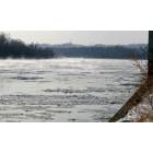
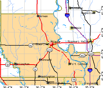
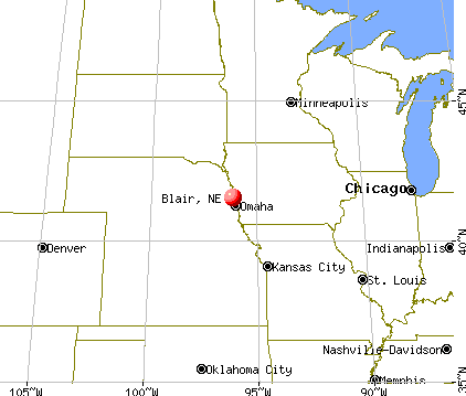
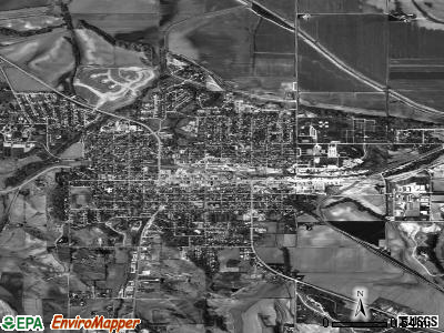
Blair, Nebraska
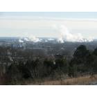
Blair: Neihardt park over looking Blair
Blair: Neihardt park over looking Blair
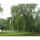
Blair: Nebraska Statewide Arboretum at Arbor Park in Blair, Nebraska. Blair has a number of great parks and walking trails!
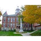
Blair: Blair, NE Courthouse
- add
your


Submit your own pictures of this city and show them to the world
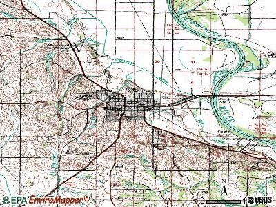
- OSM Map
- General Map
- Google Map
- MSN Map
Population change since 2000: +6.0%
 |
| Males: 3,775 | |
| Females: 4,187 |
| Median resident age: | 39.9 years |
| Nebraska median age: | 37.4 years |
Zip codes: 68008.
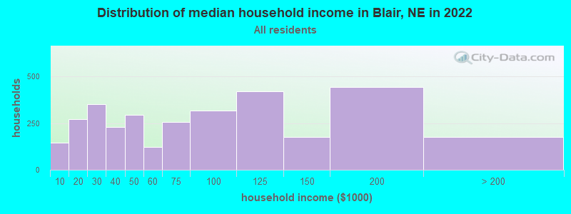
| Blair: | $71,864 |
| NE: | $69,597 |
Estimated per capita income in 2022: $37,603 (it was $19,240 in 2000)
Blair city income, earnings, and wages data
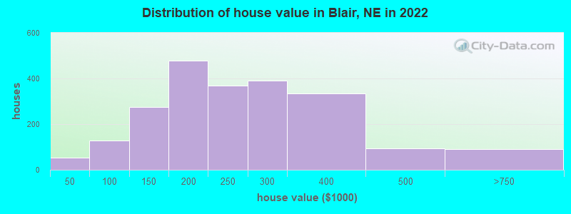
Estimated median house or condo value in 2022: $225,731 (it was $100,500 in 2000)
| Blair: | $225,731 |
| NE: | $232,400 |
Mean prices in 2022: all housing units: $245,397; detached houses: $245,025; townhouses or other attached units: $302,284; in 5-or-more-unit structures: $146,622
Median gross rent in 2022: $928.
(11.6% for White Non-Hispanic residents, 100.0% for Native Hawaiian and other Pacific Islander residents, 50.8% for two or more races residents)
Detailed information about poverty and poor residents in Blair, NE
Compare current foreclosures near Blair, NE:
| Photo | Address | Area | Beds / Baths | Price | Details |
|---|---|---|---|---|---|

|
#1
Grant St
Blair, NE 68008
|
2,002 sq. feet
|
2 baths 3 beds |
show details | |

|
#2
Pinewood Dr
Blair, NE 68008
|
2,989 sq. feet
|
2 baths 4 beds |
show details | |

|
#3
Arrowhead Dr
Blair, NE 68008
|
2,006 sq. feet
|
1 baths 3 beds |
show details | |

|
#4
Spring Dr
Blair, NE 68008
|
2,204 sq. feet
|
2 baths 3 beds |
show details | |

|
#5
Larsen Dr
Blair, NE 68008
|
1,681 sq. feet
|
1 baths 3 beds |
show details | |

|
#6
N 18th Ave Apt 1b
Blair, NE 68008
|
- sq. feet
|
- baths - beds |
show details | |

|
#7
Thompson Dr
Blair, NE 68008
|
1,232 sq. feet
|
- baths - beds |
show details | |

|
#8
Grant St
Blair, NE 68008
|
1,713 sq. feet
|
- baths - beds |
show details | |

|
#9
Lincoln St
Blair, NE 68008
|
1,273 sq. feet
|
- baths - beds |
show details | |

|
#10
Iowa Ave Apt 2
Blair, NE 68008
|
- sq. feet
|
- baths - beds |
show details |
| Photo | Address | Area | Beds / Baths | Price | Details |
|---|---|---|---|---|---|

|
#11
Soren Dr
Blair, NE 68008
|
- sq. feet
|
- baths - beds |
show details | |

|
#12
Davidson St
Bennington, NE 68007
|
1,048 sq. feet
|
2 baths 3 beds |
show details | |

|
#13
N 225th St
Valley, NE 68064
|
1,412 sq. feet
|
2 baths 3 beds |
show details | |

|
#14
Larimore Ave
Omaha, NE 68116
|
1,474 sq. feet
|
2 baths 3 beds |
show details | |

|
#15
N 75th St
Omaha, NE 68122
|
1,433 sq. feet
|
2 baths 3 beds |
show details | |

|
#16
N 151st Cir
Omaha, NE 68116
|
1,300 sq. feet
|
2 baths 3 beds |
show details | |

|
#17
N 126th St
Omaha, NE 68164
|
2,288 sq. feet
|
2 baths 4 beds |
show details | |

|
#18
N 134th Ave
Omaha, NE 68164
|
1,544 sq. feet
|
2 baths 2 beds |
show details | |

|
#19
N 78th Ter
Omaha, NE 68122
|
1,298 sq. feet
|
2 baths 3 beds |
show details | |

|
#20
N 128th St
Omaha, NE 68164
|
1,624 sq. feet
|
2 baths 3 beds |
show details |
| Photo | Address | Area | Beds / Baths | Price | Details |
|---|---|---|---|---|---|

|
#21
Rambleridge Rd
Omaha, NE 68164
|
1,594 sq. feet
|
2 baths 3 beds |
show details | |

|
#22
Nebraska Ave
Omaha, NE 68164
|
1,253 sq. feet
|
2 baths 3 beds |
show details | |

|
#23
Fort St
Omaha, NE 68116
|
2,129 sq. feet
|
1 baths 2 beds |
show details | |

|
#24
N 108th Avenue Cir
Omaha, NE 68164
|
1,726 sq. feet
|
2 baths 3 beds |
show details | |

|
#25
N 105th Ave
Omaha, NE 68122
|
2,656 sq. feet
|
2 baths 4 beds |
show details | |

|
#26
N 112th St
Omaha, NE 68164
|
1,464 sq. feet
|
2 baths 3 beds |
show details | |

|
#27
Roanoke Blvd
Omaha, NE 68164
|
1,832 sq. feet
|
2 baths 3 beds |
show details | |

|
#28
Newport Ave
Omaha, NE 68164
|
1,491 sq. feet
|
2 baths 3 beds |
show details | |

|
#29
Newport Ave
Omaha, NE 68116
|
2,310 sq. feet
|
2 baths 4 beds |
show details | |

|
#30
N 75th St
Omaha, NE 68122
|
962 sq. feet
|
1 baths 3 beds |
show details |
| Photo | Address | Area | Beds / Baths | Price | Details |
|---|---|---|---|---|---|

|
#31
Q St
Tekamah, NE 68061
|
2,960 sq. feet
|
3 baths 3 beds |
show details | |

|
#32
Roanoke Blvd
Omaha, NE 68164
|
1,902 sq. feet
|
2 baths 3 beds |
show details | |

|
#33
Grand Ave
Omaha, NE 68164
|
1,393 sq. feet
|
2 baths 3 beds |
show details | |

|
#34
Kansas Ave
Omaha, NE 68134
|
1,347 sq. feet
|
2 baths 3 beds |
show details | |

|
#35
N 91st Ave
Omaha, NE 68134
|
1,470 sq. feet
|
2 baths 3 beds |
show details | |

|
#36
Tucker St
Omaha, NE 68112
|
1,680 sq. feet
|
1 baths 3 beds |
show details | |

|
#37
Read St
Omaha, NE 68152
|
1,711 sq. feet
|
2 baths 3 beds |
show details | |

|
#38
N 105th St
Omaha, NE 68134
|
1,718 sq. feet
|
1 baths 3 beds |
show details | |

|
#39
Saratoga St
Omaha, NE 68116
|
1,506 sq. feet
|
2 baths 2 beds |
show details | |

|
#40
Grand Ave
Omaha, NE 68164
|
1,210 sq. feet
|
1 baths 3 beds |
show details |
| Photo | Address | Area | Beds / Baths | Price | Details |
|---|---|---|---|---|---|

|
#41
Camden Ave
Omaha, NE 68116
|
1,562 sq. feet
|
2 baths 2 beds |
show details | |

|
#42
Himebaugh Ave
Omaha, NE 68134
|
1,644 sq. feet
|
2 baths 4 beds |
show details | |

|
#43
N 78th St
Omaha, NE 68122
|
2,267 sq. feet
|
2 baths 3 beds |
show details | |

|
#44
Redman Ave
Omaha, NE 68116
|
1,611 sq. feet
|
2 baths 3 beds |
show details | |

|
#45
N 79th Cir
Omaha, NE 68134
|
1,329 sq. feet
|
2 baths 3 beds |
show details | |

|
#46
N 128th St
Omaha, NE 68164
|
1,449 sq. feet
|
2 baths 3 beds |
show details | |

|
#47
N 230th St
Elkhorn, NE 68022
|
2,332 sq. feet
|
2 baths 3 beds |
show details | |

|
#48
Park Lane Cir
Omaha, NE 68164
|
1,418 sq. feet
|
2 baths 2 beds |
show details | |

|
#49
Whitmore Ct # 288
Omaha, NE 68142
|
924 sq. feet
|
1 baths 2 beds |
show details | |

|
Check over 1 million property listings on Foreclosure.com!
|
browse all offers | |||


- 7,29693.0%White alone
- 1702.2%Hispanic
- 1511.9%Two or more races
- 811.0%Black alone
- 390.5%Native Hawaiian and Other
Pacific Islander alone - 240.3%Asian alone
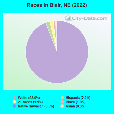
Races in Blair detailed stats: ancestries, foreign born residents, place of birth
According to our research of Nebraska and other state lists, there were 26 registered sex offenders living in Blair, Nebraska as of April 26, 2024.
The ratio of all residents to sex offenders in Blair is 312 to 1.
Type |
2009 |
2010 |
2011 |
2012 |
2013 |
2014 |
2015 |
2016 |
2017 |
2018 |
2019 |
2020 |
2021 |
2022 |
|---|---|---|---|---|---|---|---|---|---|---|---|---|---|---|
| Murders (per 100,000) | 0 (0.0) | 0 (0.0) | 0 (0.0) | 0 (0.0) | 0 (0.0) | 0 (0.0) | 0 (0.0) | 0 (0.0) | 0 (0.0) | 0 (0.0) | 0 (0.0) | 0 (0.0) | 0 (0.0) | 0 (0.0) |
| Rapes (per 100,000) | 2 (25.6) | 8 (100.1) | 0 (0.0) | 2 (24.8) | 5 (62.7) | 8 (100.2) | 2 (25.1) | 4 (50.2) | 7 (86.4) | 3 (37.0) | 5 (63.8) | 7 (88.4) | 6 (75.2) | 3 (38.2) |
| Robberies (per 100,000) | 0 (0.0) | 0 (0.0) | 1 (12.4) | 2 (24.8) | 2 (25.1) | 1 (12.5) | 1 (12.5) | 1 (12.5) | 0 (0.0) | 1 (12.3) | 2 (25.5) | 0 (0.0) | 0 (0.0) | 0 (0.0) |
| Assaults (per 100,000) | 0 (0.0) | 2 (25.0) | 2 (24.8) | 3 (37.2) | 1 (12.5) | 3 (37.6) | 7 (87.7) | 5 (62.7) | 4 (49.4) | 4 (49.4) | 3 (38.3) | 5 (63.1) | 6 (75.2) | 3 (38.2) |
| Burglaries (per 100,000) | 12 (153.5) | 19 (237.8) | 8 (99.2) | 20 (247.9) | 29 (363.5) | 16 (200.4) | 16 (200.5) | 16 (200.8) | 9 (111.1) | 17 (209.8) | 11 (140.4) | 6 (75.8) | 4 (50.1) | 8 (101.8) |
| Thefts (per 100,000) | 101 (1,292) | 102 (1,277) | 87 (1,079) | 93 (1,153) | 75 (940.1) | 85 (1,064) | 98 (1,228) | 81 (1,016) | 69 (851.5) | 96 (1,185) | 87 (1,110) | 50 (631.4) | 49 (614.1) | 58 (738.4) |
| Auto thefts (per 100,000) | 8 (102.3) | 5 (62.6) | 2 (24.8) | 13 (161.1) | 5 (62.7) | 6 (75.1) | 4 (50.1) | 5 (62.7) | 6 (74.0) | 16 (197.5) | 21 (268.0) | 11 (138.9) | 10 (125.3) | 3 (38.2) |
| Arson (per 100,000) | 0 (0.0) | 4 (50.1) | 2 (24.8) | 0 (0.0) | 1 (12.5) | 0 (0.0) | 0 (0.0) | 0 (0.0) | 0 (0.0) | 1 (12.3) | 2 (25.5) | 1 (12.6) | 0 (0.0) | 0 (0.0) |
| City-Data.com crime index | 91.0 | 157.8 | 60.8 | 111.0 | 128.2 | 154.0 | 108.5 | 116.2 | 126.7 | 121.1 | 142.0 | 125.0 | 113.3 | 77.9 |
The City-Data.com crime index weighs serious crimes and violent crimes more heavily. Higher means more crime, U.S. average is 246.1. It adjusts for the number of visitors and daily workers commuting into cities.
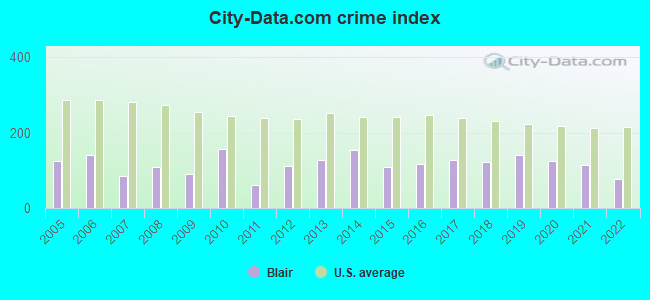
Crime rate in Blair detailed stats: murders, rapes, robberies, assaults, burglaries, thefts, arson
Full-time law enforcement employees in 2021, including police officers: 15 (13 officers - 13 male; 0 female).
| Officers per 1,000 residents here: | 1.63 |
| US average: | 2.38 |
 Recent articles from our blog. Our writers, many of them Ph.D. graduates or candidates, create easy-to-read articles on a wide variety of topics.


 | How is North Platte these days? Kearney? (11 replies) |
| Elkhorn vs. Papillion (13 replies) |
| How is life in Nebraska? (20 replies) |
| Pictures of Omaha (159 replies) |
| ~ NEW POST in the Nebraska City-Data Forums' sub-forum ~ (30 replies) |
| Chicken Farm-How many miles do they smell for? (2 replies) |
Latest news from Blair, NE collected exclusively by city-data.com from local newspapers, TV, and radio stations
Ancestries: German (39.5%), Danish (10.8%), Norwegian (8.6%), Irish (6.9%), English (5.3%), American (4.9%).
Current Local Time: CST time zone
Incorporated on 08/7/1869
Elevation: 1090 feet
Land area: 4.64 square miles.
Population density: 1,714 people per square mile (low).
112 residents are foreign born
| This city: | 1.4% |
| Nebraska: | 7.5% |
Median real estate property taxes paid for housing units with mortgages in 2022: $3,269 (1.3%)
Median real estate property taxes paid for housing units with no mortgage in 2022: $3,081 (1.5%)
Nearest city with pop. 50,000+: Omaha, NE  (20.7 miles , pop. 390,007).
Nearest city with pop. 1,000,000+: Chicago, IL (437.0 miles , pop. 2,896,016).
Nearest cities:
), ), ), ), Latitude: 41.55 N, Longitude: 96.13 W
Daytime population change due to commuting: +1,081 (+13.8%)
Workers who live and work in this city: 2,110 (54.7%)
Area code: 402
Blair, Nebraska accommodation & food services, waste management - Economy and Business Data
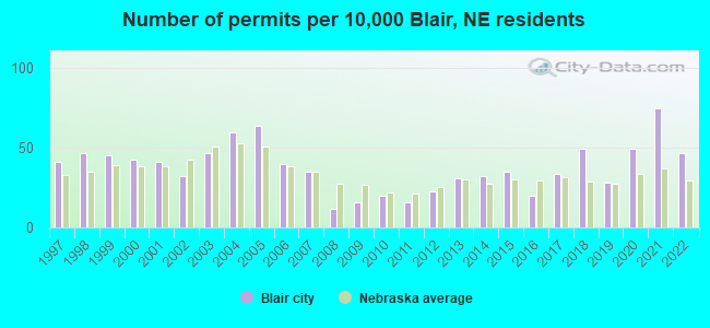
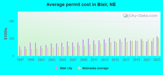
Single-family new house construction building permits:
- 2022: 35 buildings, average cost: $217,200
- 2021: 56 buildings, average cost: $210,400
- 2020: 37 buildings, average cost: $246,900
- 2019: 21 buildings, average cost: $223,000
- 2018: 37 buildings, average cost: $222,900
- 2017: 25 buildings, average cost: $264,000
- 2016: 15 buildings, average cost: $241,800
- 2015: 26 buildings, average cost: $219,400
- 2014: 24 buildings, average cost: $265,300
- 2013: 23 buildings, average cost: $241,200
- 2012: 17 buildings, average cost: $227,300
- 2011: 12 buildings, average cost: $228,000
- 2010: 15 buildings, average cost: $254,800
- 2009: 12 buildings, average cost: $239,500
- 2008: 9 buildings, average cost: $201,400
- 2007: 26 buildings, average cost: $200,800
- 2006: 30 buildings, average cost: $213,400
- 2005: 48 buildings, average cost: $193,800
- 2004: 45 buildings, average cost: $184,700
- 2003: 35 buildings, average cost: $183,800
- 2002: 24 buildings, average cost: $162,100
- 2001: 31 buildings, average cost: $150,000
- 2000: 32 buildings, average cost: $194,100
- 1999: 34 buildings, average cost: $195,400
- 1998: 35 buildings, average cost: $140,900
- 1997: 31 buildings, average cost: $140,800
| Here: | 2.0% |
| Nebraska: | 2.2% |
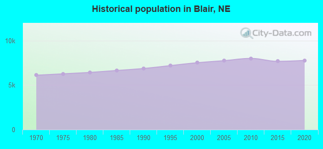
Population change in the 1990s: +499 (+7.1%).
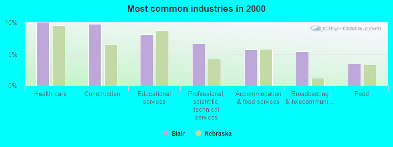
- Health care (10.0%)
- Construction (9.7%)
- Educational services (8.2%)
- Professional, scientific, technical services (6.7%)
- Accommodation & food services (5.7%)
- Broadcasting & telecommunications (5.4%)
- Food (3.5%)
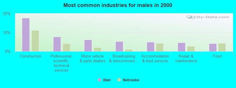
- Construction (17.7%)
- Professional, scientific, technical services (7.8%)
- Motor vehicle & parts dealers (6.1%)
- Broadcasting & telecommunications (5.2%)
- Accommodation & food services (4.9%)
- Repair & maintenance (4.6%)
- Food (4.2%)
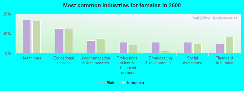
- Health care (17.0%)
- Educational services (12.6%)
- Accommodation & food services (6.5%)
- Professional, scientific, technical services (5.6%)
- Broadcasting & telecommunications (5.6%)
- Social assistance (5.6%)
- Finance & insurance (4.8%)
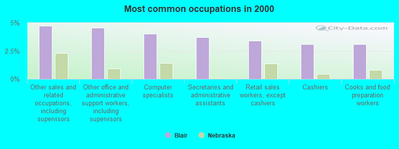
- Other sales and related occupations, including supervisors (4.7%)
- Other office and administrative support workers, including supervisors (4.6%)
- Computer specialists (4.0%)
- Secretaries and administrative assistants (3.7%)
- Retail sales workers, except cashiers (3.4%)
- Cashiers (3.1%)
- Cooks and food preparation workers (3.1%)
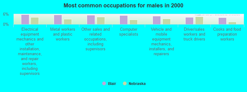
- Electrical equipment mechanics and other installation, maintenance, and repair workers, including supervisors (5.8%)
- Metal workers and plastic workers (5.6%)
- Other sales and related occupations, including supervisors (5.4%)
- Computer specialists (5.2%)
- Vehicle and mobile equipment mechanics, installers, and repairers (4.9%)
- Driver/sales workers and truck drivers (4.2%)
- Cooks and food preparation workers (4.0%)
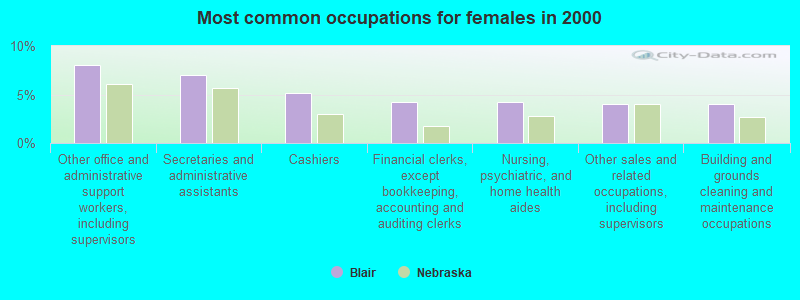
- Other office and administrative support workers, including supervisors (8.1%)
- Secretaries and administrative assistants (7.0%)
- Cashiers (5.1%)
- Financial clerks, except bookkeeping, accounting and auditing clerks (4.2%)
- Nursing, psychiatric, and home health aides (4.2%)
- Other sales and related occupations, including supervisors (4.0%)
- Building and grounds cleaning and maintenance occupations (4.0%)
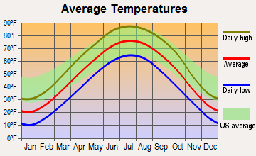
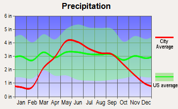
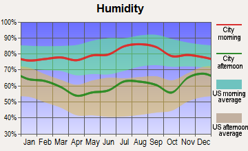
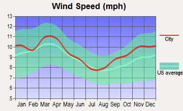
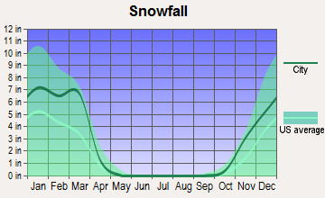
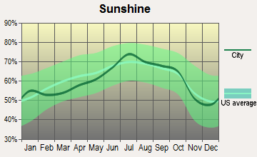
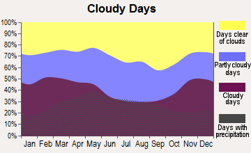
Average climate in Blair, Nebraska
Based on data reported by over 4,000 weather stations
|
|

(lower is better)
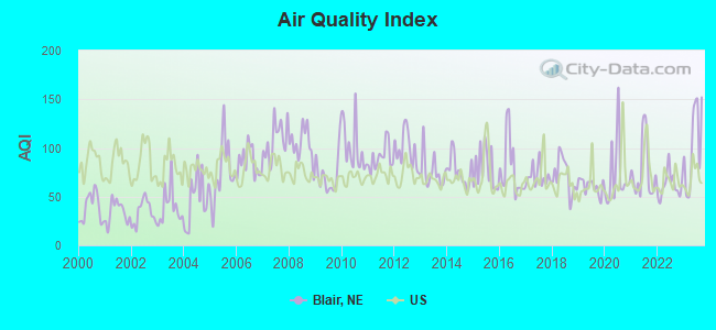
Air Quality Index (AQI) level in 2023 was 102. This is significantly worse than average.
| City: | 102 |
| U.S.: | 73 |
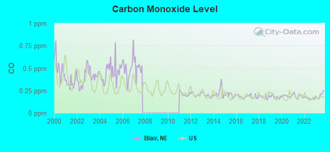
Carbon Monoxide (CO) [ppm] level in 2023 was 0.195. This is better than average. Closest monitor was 18.8 miles away from the city center.
| City: | 0.195 |
| U.S.: | 0.251 |
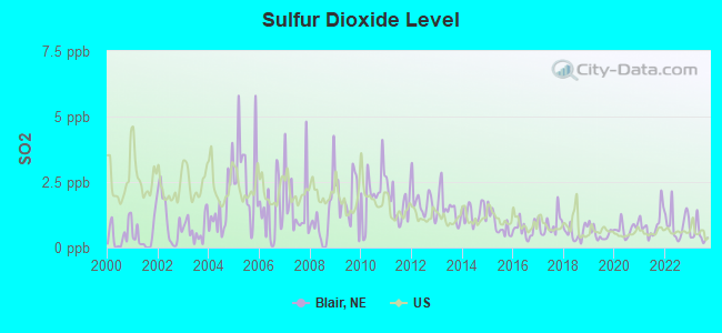
Sulfur Dioxide (SO2) [ppb] level in 2023 was 0.507. This is significantly better than average. Closest monitor was 14.0 miles away from the city center.
| City: | 0.507 |
| U.S.: | 1.515 |
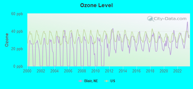
Ozone [ppb] level in 2023 was 35.6. This is about average. Closest monitor was 14.0 miles away from the city center.
| City: | 35.6 |
| U.S.: | 33.3 |
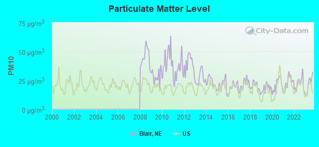
Particulate Matter (PM10) [µg/m3] level in 2023 was 21.9. This is about average. Closest monitor was 20.5 miles away from the city center.
| City: | 21.9 |
| U.S.: | 19.2 |
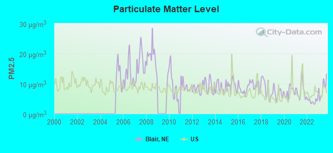
Particulate Matter (PM2.5) [µg/m3] level in 2023 was 8.30. This is about average. Closest monitor was 0.7 miles away from the city center.
| City: | 8.30 |
| U.S.: | 8.11 |
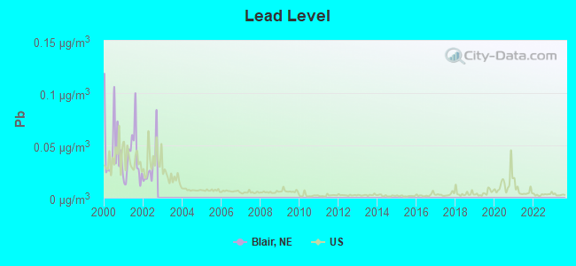
Lead (Pb) [µg/m3] level in 2002 was 0.0298. This is significantly worse than average. Closest monitor was 22.2 miles away from the city center.
| City: | 0.0298 |
| U.S.: | 0.0093 |
Tornado activity:
Blair-area historical tornado activity is near Nebraska state average. It is 83% greater than the overall U.S. average.
On 5/6/1975, a category F4 (max. wind speeds 207-260 mph) tornado 19.3 miles away from the Blair city center killed 3 people and injured 133 people and caused between $50,000 and $500,000 in damages.
On 7/15/1950, a category F4 tornado 19.5 miles away from the city center injured 33 people and caused between $500,000 and $5,000,000 in damages.
Earthquake activity:
Blair-area historical earthquake activity is significantly above Nebraska state average. It is 296% greater than the overall U.S. average.On 9/3/2016 at 12:02:44, a magnitude 5.8 (5.8 MW, Depth: 3.5 mi, Class: Moderate, Intensity: VI - VII) earthquake occurred 356.7 miles away from Blair center
On 11/3/2002 at 20:41:56, a magnitude 4.3 (4.3 MB, Depth: 3.1 mi, Class: Light, Intensity: IV - V) earthquake occurred 164.9 miles away from Blair center
On 11/6/2011 at 03:53:10, a magnitude 5.7 (5.7 MW, Depth: 3.2 mi) earthquake occurred 417.3 miles away from the city center
On 6/22/2019 at 08:50:24, a magnitude 4.6 (4.6 MW, Depth: 1.9 mi) earthquake occurred 236.7 miles away from the city center
On 3/4/1983 at 06:32:18, a magnitude 4.6 (4.4 MB, 4.6 LG, 4.4 ML) earthquake occurred 248.2 miles away from the city center
On 11/12/2014 at 21:40:00, a magnitude 4.9 (4.9 MW, Depth: 2.5 mi) earthquake occurred 306.1 miles away from the city center
Magnitude types: regional Lg-wave magnitude (LG), body-wave magnitude (MB), local magnitude (ML), moment magnitude (MW)
Natural disasters:
The number of natural disasters in Washington County (16) is near the US average (15).Major Disasters (Presidential) Declared: 12
Emergencies Declared: 2
Causes of natural disasters: Floods: 12, Storms: 8, Tornadoes: 5, Snows: 2, Winds: 2, Winter Storms: 2, Hurricane: 1, Snowstorm: 1, Other: 1 (Note: some incidents may be assigned to more than one category).
Hospitals and medical centers in Blair:
Airports located in Blair:
- Blair Municipal Airport (BTA) (Runways: 1, Itinerant Ops: 1,600, Local Ops: 13,900)
- Orum Aerodrome Airport (86NE) (Runways: 1)
Operable nuclear power plant near Blair:
- 9 miles: Fort Calhoun in Fort Calhoun, NE.
Colleges/universities with over 2000 students nearest to Blair:
- Metropolitan Community College Area (about 19 miles; Omaha, NE; Full-time enrollment: 12,236)
- University of Nebraska at Omaha (about 21 miles; Omaha, NE; FT enrollment: 12,073)
- Creighton University (about 22 miles; Omaha, NE; FT enrollment: 5,370)
- University of Nebraska Medical Center (about 22 miles; Omaha, NE; FT enrollment: 2,815)
- Iowa Western Community College (about 26 miles; Council Bluffs, IA; FT enrollment: 5,344)
- Bellevue University (about 30 miles; Bellevue, NE; FT enrollment: 7,139)
- Nebraska Wesleyan University (about 56 miles; Lincoln, NE; FT enrollment: 2,072)
Public high school in Blair:
- BLAIR HIGH SCHOOL (Students: 705, Location: 440 N 10TH ST, Grades: 9-12)
Public elementary/middle schools in Blair:
- GERALD OTTE BLAIR MIDDLE SCH (Students: 538, Location: 555 JACKSON ST, Grades: 6-8)
- BLAIR ARBOR PARK INTERMEDIATE SCHOOL (Students: 487, Location: 1717 ADAMS ST, Grades: 4-5)
- BLAIR NORTH ELEMENTARY SCHOOL (Students: 234, Location: 1326 PARK ST, Grades: PK-3)
- BLAIR SOUTH ELEMENTARY SCHOOL (Students: 203, Location: 1616 BUTLER ST, Grades: PK-3)
- BLAIR WEST ELEMENTARY SCHOOL (Students: 153, Location: 2232 WASHINGTON, Grades: PK-3)
- DEERFIELD ELEMENTARY SCHOOL (Location: 1100 DEERFIELD BLV, Grades: PK-3)
Points of interest:
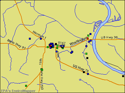
Notable locations in Blair: Municipal RV Park (A), Blair Feed Mill Elevator (B), Mathiesen Grain Company Elevator (C), Tyson Elevators (D), Blair Golf Club (E), Blair (F), Omaha Village Apartments (G), C A Dana Hall of Science (H), Madsen Fine Arts Center (I), C A Dana - Life Library (J), Blair Hall (K), Mickelsen Hall (L), Borup Coliseum (M), Rasmussen Hall (N), Holling Hall (O), E C Hunt Campus Center (P), Argo Hall (Q), Elk Horn Hall Conference-Retreat Center (R), Pioneer Memorial Building (S), Dana Classroom Center (T). Display/hide their locations on the map
Churches in Blair include: United Church of Christ (A), First United Methodist Church (B), Saint Marys Episcopal Church (C), Cornerstone Assembly of God Church (D), First Lutheran Church (E), Church of Christ (F), First Baptist Church (G), Trinity Lutheran Church (H), First Christian Church (I). Display/hide their locations on the map
Cemetery: Blair Cemetery (1). Display/hide its location on the map
Parks in Blair include: Rhoades Park (1), Congregational Church of Blair Historical Marker (2), Tower of the Four Winds (3), Peterson Field (4), Zimmerman Field (5), Viking Field (6), Veterans Memorial Ball Field (7), Ralph Steyer Park (8), Lions Club Park (9). Display/hide their locations on the map
Hotels: Super 8 Motel (558 South 13th Street), Motel California (2829 South Highway 30), Ray's Towing (East Highway 30), Econo Lodge Blair (1355 Highway 30), Starlite Motel (648 East Highway 30), Econo Lodge (1355 South Highway 30), Super 8 Blair NE (558 South 13th Street), Landmark Inn (1465 Front Street).
Courts: Blair - Washington County Court House- Extension Services (1718 Washington Street), Washington County Court House - Attorney (1555 Colfax Street), Washington County Court House - Assessor (1555 Colfax Street).
Birthplace of: Kent Bellows - Artist, Gene Williams - Football player, Kent Rogert - Politician, Otto Diller Schmidt - Navy Medal of Honor recipient, Tom Seaton - Baseball player.
Drinking water stations with addresses in Blair and their reported violations in the past:
BLAIR, CITY OF (Population served: 8,000, Surface water):Past health violations:SHANNON ESTATES (Population served: 70, Purch surface water):Past monitoring violations:
- MCL, Monthly (TCR) - In JUN-2012, Contaminant: Coliform. Follow-up actions: St Public Notif requested (JUN-13-2012), St Violation/Reminder Notice (JUN-13-2012), St Public Notif received (JUL-10-2012)
- MCL, Monthly (TCR) - In JUL-2010, Contaminant: Coliform. Follow-up actions: St Public Notif requested (AUG-09-2010), St Violation/Reminder Notice (AUG-09-2010), St Public Notif received (SEP-21-2010)
- MCL, Monthly (TCR) - In JUN-2008, Contaminant: Coliform. Follow-up actions: St Public Notif requested (JUN-27-2008), St Violation/Reminder Notice (JUN-27-2008), St Public Notif received (JUL-15-2008)
- Monitoring of Treatment (SWTR-Filter) - In JAN-2009. Follow-up actions: St Public Notif requested (MAR-05-2009), St Violation/Reminder Notice (MAR-05-2009), St Public Notif received (APR-01-2009)
- Monitoring of Treatment (SWTR-Filter) - In DEC-2008. Follow-up actions: St Public Notif requested (MAR-05-2009), St Violation/Reminder Notice (MAR-05-2009), St Public Notif received (APR-01-2009)
- Monitoring of Treatment (SWTR-Filter) - In NOV-2008. Follow-up actions: St Public Notif requested (MAR-05-2009), St Violation/Reminder Notice (MAR-05-2009), St Public Notif received (APR-01-2009)
- Monitoring of Treatment (SWTR-Filter) - In OCT-2008. Follow-up actions: St Public Notif requested (MAR-05-2009), St Violation/Reminder Notice (MAR-05-2009), St Public Notif received (APR-01-2009)
- Monitoring of Treatment (SWTR-Filter) - In SEP-2008. Follow-up actions: St Public Notif requested (MAR-05-2009), St Violation/Reminder Notice (MAR-05-2009), St Public Notif received (APR-01-2009)
- 3 other older monitoring violations
Past health violations:Past monitoring violations:
- MCL, Average - Between APR-2010 and JUN-2010, Contaminant: TTHM. Follow-up actions: St Public Notif requested (AUG-27-2010), St Violation/Reminder Notice (AUG-27-2010), St Public Notif received (SEP-20-2010), St Compliance achieved (SEP-30-2010)
- Monitoring, Repeat Major (TCR) - In OCT-2007, Contaminant: Coliform (TCR). Follow-up actions: St Public Notif requested (NOV-02-2007), St Violation/Reminder Notice (NOV-02-2007), St Public Notif received (NOV-16-2007)
| This city: | 2.4 people |
| Nebraska: | 2.5 people |
| This city: | 64.5% |
| Whole state: | 64.8% |
| This city: | 4.9% |
| Whole state: | 6.0% |
Likely homosexual households (counted as self-reported same-sex unmarried-partner households)
- Lesbian couples: 0.2% of all households
- Gay men: 0.2% of all households
People in group quarters in Blair in 2010:
- 357 people in college/university student housing
- 155 people in nursing facilities/skilled-nursing facilities
- 23 people in local jails and other municipal confinement facilities
People in group quarters in Blair in 2000:
- 314 people in college dormitories (includes college quarters off campus)
- 193 people in nursing homes
- 30 people in local jails and other confinement facilities (including police lockups)
- 6 people in hospitals/wards and hospices for chronically ill
- 6 people in other hospitals or wards for chronically ill
- 6 people in homes for the physically handicapped
Banks with branches in Blair (2011 data):
- U.S. Bank National Association: Blair Branch at 1865 Washington, branch established on 1907/09/01. Info updated 2012/01/30: Bank assets: $330,470.8 mil, Deposits: $236,091.5 mil, headquarters in Cincinnati, OH, positive income, 3121 total offices, Holding Company: U.S. Bancorp
- Two Rivers Bank: at 555 South 19th Street, branch established on 1997/02/03. Info updated 2008/11/25: Bank assets: $129.8 mil, Deposits: $96.3 mil, local headquarters, positive income, Agricultural Specialization, 2 total offices, Holding Company: Arlington State Banc Holding Company
- Lincoln FSB of Nebraska: Blair Branch at 1822 Washington Street, branch established on 1994/06/20. Info updated 2011/07/21: Bank assets: $331.9 mil, Deposits: $232.1 mil, headquarters in Lincoln, NE, negative income in the last year, Commercial Lending Specialization, 14 total offices
- Washington County Bank: at 1523 Washington Street, branch established on 1915/07/01. Info updated 2006/11/03: Bank assets: $290.1 mil, Deposits: $223.2 mil, local headquarters, positive income, Agricultural Specialization, 2 total offices, Holding Company: Lauritzen Corporation
For population 15 years and over in Blair:
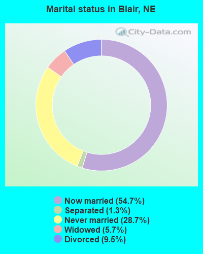
- Never married: 28.7%
- Now married: 54.7%
- Separated: 1.3%
- Widowed: 5.7%
- Divorced: 9.5%
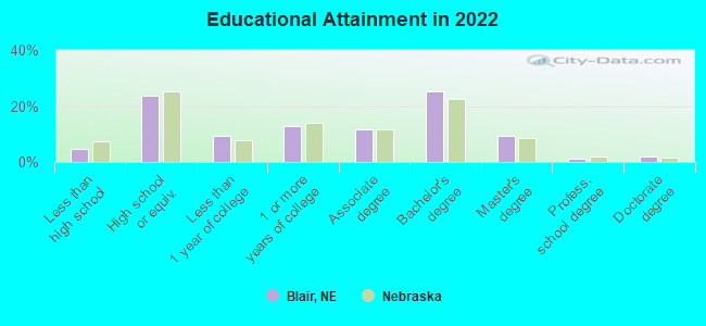
For population 25 years and over in Blair:
- High school or higher: 94.6%
- Bachelor's degree or higher: 36.7%
- Graduate or professional degree: 12.3%
- Unemployed: 4.5%
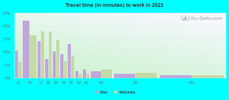
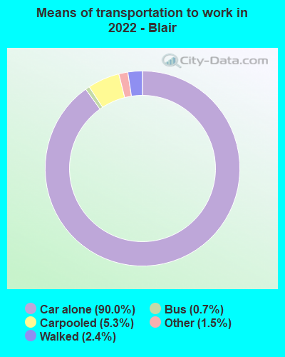
- Mean travel time to work (commute): 18.6 minutes
| Here: | 9.8 |
| Nebraska average: | 11.2 |
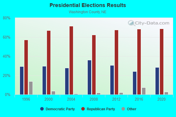
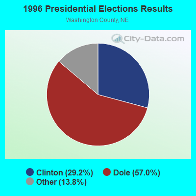


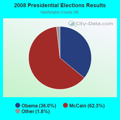
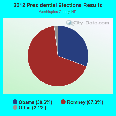
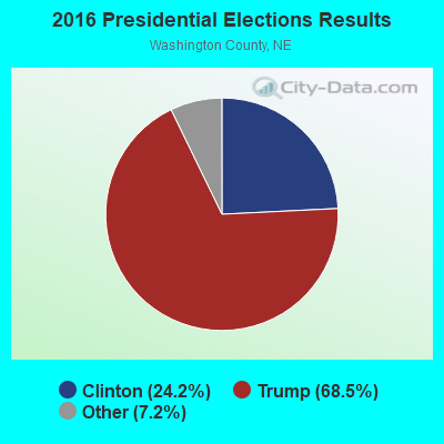

Graphs represent county-level data. Detailed 2008 Election Results
Religion statistics for Blair, NE (based on Washington County data)
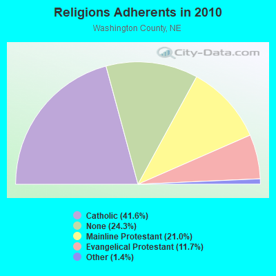
| Religion | Adherents | Congregations |
|---|---|---|
| Catholic | 8,421 | 3 |
| Mainline Protestant | 4,240 | 11 |
| Evangelical Protestant | 2,368 | 10 |
| Other | 283 | 2 |
| None | 4,922 | - |
Food Environment Statistics:
| Washington County: | 2.51 / 10,000 pop. |
| Nebraska: | 2.60 / 10,000 pop. |
| This county: | 3.01 / 10,000 pop. |
| Nebraska: | 4.83 / 10,000 pop. |
| Washington County: | 7.03 / 10,000 pop. |
| Nebraska: | 7.76 / 10,000 pop. |
| Washington County: | 7.7% |
| Nebraska: | 7.9% |
| This county: | 27.2% |
| State: | 28.0% |
| Here: | 11.0% |
| State: | 12.9% |
Health and Nutrition:
| Blair: | 47.0% |
| State: | 48.9% |
| Blair: | 41.6% |
| Nebraska: | 45.5% |
| This city: | 28.6 |
| Nebraska: | 28.6 |
| This city: | 21.1% |
| Nebraska: | 21.4% |
| Blair: | 11.9% |
| Nebraska: | 10.5% |
| This city: | 6.8 |
| State: | 6.8 |
| This city: | 33.5% |
| Nebraska: | 33.5% |
| Here: | 53.3% |
| State: | 55.6% |
| Blair: | 76.5% |
| Nebraska: | 78.2% |
More about Health and Nutrition of Blair, NE Residents
| Local government employment and payroll (March 2022) | |||||
| Function | Full-time employees | Monthly full-time payroll | Average yearly full-time wage | Part-time employees | Monthly part-time payroll |
|---|---|---|---|---|---|
| Other Government Administration | 15 | $52,755 | $42,204 | 1 | $80 |
| Police Protection - Officers | 13 | $87,868 | $81,109 | 0 | $0 |
| Water Supply | 10 | $50,627 | $60,752 | 0 | $0 |
| Streets and Highways | 7 | $42,397 | $72,681 | 1 | $1,667 |
| Other and Unallocable | 3 | $13,811 | $55,244 | 0 | $0 |
| Local Libraries | 3 | $13,217 | $52,868 | 6 | $7,048 |
| Parks and Recreation | 3 | $13,917 | $55,668 | 1 | $66 |
| Sewerage | 2 | $11,543 | $69,258 | 0 | $0 |
| Police - Other | 2 | $7,294 | $43,764 | 0 | $0 |
| Financial Administration | 1 | $9,100 | $109,200 | 0 | $0 |
| Health | 0 | $0 | 1 | $1,692 | |
| Totals for Government | 59 | $302,530 | $61,532 | 10 | $10,553 |
Blair government finances - Expenditure in 2021 (per resident):
- Construction - Regular Highways: $2,620,000 ($329.06)
Parks and Recreation: $593,000 ($74.48)
Libraries: $198,000 ($24.87)
Police Protection: $196,000 ($24.62)
Local Fire Protection: $126,000 ($15.83)
Central Staff Services: $112,000 ($14.07)
Financial Administration: $86,000 ($10.80)
General Public Buildings: $17,000 ($2.14)
- Current Operations - Police Protection: $1,560,000 ($195.93)
Regular Highways: $1,456,000 ($182.87)
Housing and Community Development: $1,248,000 ($156.74)
Parks and Recreation: $1,187,000 ($149.08)
Local Fire Protection: $997,000 ($125.22)
Central Staff Services: $653,000 ($82.01)
Financial Administration: $502,000 ($63.05)
Libraries: $396,000 ($49.74)
General Public Buildings: $100,000 ($12.56)
- General - Interest on Debt: $105,000 ($13.19)
- Other Capital Outlay - Regular Highways: $257,000 ($32.28)
Police Protection: $142,000 ($17.83)
Local Fire Protection: $91,000 ($11.43)
Parks and Recreation: $40,000 ($5.02)
Libraries: $13,000 ($1.63)
Central Staff Services: $9,000 ($1.13)
Financial Administration: $7,000 ($0.88)
General Public Building: $1,000 ($0.13)
- Total Salaries and Wages: $3,807,000 ($478.15)
Blair government finances - Revenue in 2021 (per resident):
- Charges - Other: $24,512,000 ($3078.62)
Parks and Recreation: $261,000 ($32.78)
- Federal Intergovernmental - Other: $150,000 ($18.84)
- Local Intergovernmental - General Local Government Support: $84,000 ($10.55)
- Miscellaneous - Interest Earnings: $91,000 ($11.43)
- State Intergovernmental - Highways: $824,000 ($103.49)
Other: $744,000 ($93.44)
General Local Government Support: $83,000 ($10.42)
- Tax - General Sales and Gross Receipts: $2,790,000 ($350.41)
Property: $2,470,000 ($310.22)
Blair government finances - Debt in 2021 (per resident):
- Long Term Debt - Outstanding Unspecified Public Purpose: $30,275,000 ($3802.44)
Issue, Unspecified Public Purpose: $28,544,000 ($3585.03)
Beginning Outstanding - Unspecified Public Purpose: $2,627,000 ($329.94)
Retired Unspecified Public Purpose: $896,000 ($112.53)
Blair government finances - Cash and Securities in 2021 (per resident):
- Bond Funds - Cash and Securities: $23,140,000 ($2906.30)
- Other Funds - Cash and Securities: $4,536,000 ($569.71)
| Businesses in Blair, NE | ||||
| Name | Count | Name | Count | |
|---|---|---|---|---|
| Ace Hardware | 1 | New Balance | 1 | |
| Burger King | 1 | Pizza Hut | 1 | |
| Chevrolet | 1 | RadioShack | 1 | |
| Dairy Queen | 1 | Subway | 1 | |
| Econo Lodge | 1 | Super 8 | 1 | |
| FedEx | 1 | Taco Bell | 1 | |
| Ford | 1 | U-Haul | 1 | |
| H&R Block | 1 | U.S. Cellular | 1 | |
| KFC | 1 | UPS | 1 | |
| MasterBrand Cabinets | 1 | Walgreens | 1 | |
| McDonald's | 1 | YMCA | 1 | |
Strongest AM radio stations in Blair:
- KKAR (1290 AM; 50 kW; OMAHA, NE; Owner: WAITT RADIO, INC.)
- KFAB (1110 AM; 50 kW; OMAHA, NE; Owner: CAPSTAR TX LIMITED PARTNERSHIP)
- KOIL (1020 AM; 50 kW; PLATTSMOUTH, NE; Owner: WAITT RADIO, INC.)
- KYDZ (1180 AM; 25 kW; BELLEVUE, NE; Owner: WAITT RADIO, INC.)
- KOMJ (590 AM; 5 kW; OMAHA, NE; Owner: JOURNAL BROADCAST CORPORATION)
- KOZN (1620 AM; 10 kW; BELLEVUE, NE; Owner: WAITT RADIO, INC.)
- KLNG (1560 AM; daytime; 10 kW; COUNCIL BLUFFS, IA)
- KTIC (840 AM; daytime; 5 kW; WEST POINT, NE; Owner: WEST POINT BROADCASTING, INC.)
- KCRO (660 AM; 1 kW; OMAHA, NE; Owner: ETERNAL BROADCASTING, LLC)
- WHO (1040 AM; 50 kW; DES MOINES, IA; Owner: CITICASTERS LICENSES, L.P.)
- WHB (810 AM; 50 kW; KANSAS CITY, MO; Owner: UNION BROADCASTING, INC.)
- KRVN (880 AM; 50 kW; LEXINGTON, NE; Owner: NEBRASKA RURAL RADIO ASSOCIATION)
- KMMJ (750 AM; 10 kW; GRAND ISLAND, NE; Owner: JRK BROADCASTING, L.L.C.)
Strongest FM radio stations in Blair:
- KKYY (101.3 FM; WHITING, IA; Owner: WMMP, LLC)
- KMLV (88.1 FM; RALSTON, NE; Owner: EDUCATIONAL MEDIA FOUNDATION)
- KGOR (99.9 FM; OMAHA, NE; Owner: CAPSTAR TX LIMITED PARTNERSHIP)
- KEZO-FM (92.3 FM; OMAHA, NE; Owner: JOURNAL BROADCAST CORPORATION)
- KDCV-FM (91.1 FM; BLAIR, NE; Owner: DANA COLLEGE)
- KQKQ-FM (98.5 FM; COUNCIL BLUFFS, IA; Owner: WAITT RADIO, INC.)
- KQCH (94.1 FM; OMAHA, NE; Owner: JOURNAL BROADCAST CORPORATION)
- KIWR (89.7 FM; COUNCIL BLUFFS, IA; Owner: IOWA WESTERN COMMUNITY COLLEGE)
- KSRZ (104.5 FM; OMAHA, NE; Owner: JOURNAL BROADCAST CORPORATION)
- KVNO (90.7 FM; OMAHA, NE; Owner: THE BOARD OF REGENTS OF UNIV. OF NEBRASKA)
- KEFM (96.1 FM; OMAHA, NE; Owner: WEBSTER COMMUNICATIONS CO.)
- KKCD (105.9 FM; OMAHA, NE; Owner: JOURNAL BROADCAST CORPORATION)
- KBLR-FM (97.3 FM; BLAIR, NE; Owner: WAITT RADIO, INC.)
- KVSS (88.9 FM; OMAHA, NE; Owner: VSS CATHOLIC COMMUNICATIONS, INC.)
- KIOS-FM (91.5 FM; OMAHA, NE; Owner: DOUGLAS COUNTY SCHOOL DISTRICT 001)
- KLTQ (101.9 FM; LINCOLN, NE; Owner: WAITT RADIO, INC.)
- KXKT (103.7 FM; GLENWOOD, IA; Owner: CAPSTAR TX LIMITED PARTNERSHIP)
- KRQC (93.3 FM; BENNINGTON, NE; Owner: CAPSTAR TX LIMITED PARTNERSHIP)
- KGBI-FM (100.7 FM; OMAHA, NE; Owner: GRACE UNIVERSITY)
- KFMT-FM (105.5 FM; FREMONT, NE; Owner: WAITT RADIO, INC.)
TV broadcast stations around Blair:
- KMTV (Channel 3; OMAHA, NE; Owner: EMMIS TELEVISION LICENSE CORPORATION)
- KETV (Channel 7; OMAHA, NE; Owner: KETV HEARST-ARGYLE TELEVISION, INC.)
- K68AV (Channel 68; BLAIR, NE; Owner: NEBRASKA EDTV COMMISSION)
- KYNE-TV (Channel 26; OMAHA, NE; Owner: NEBRASKA EDUCATIONAL TELECOMMUNICATIONS COMM.)
- WOWT-TV (Channel 6; OMAHA, NE; Owner: GRAY MIDAMERICA TV LICENSEE CORP.)
- KVSS-LP (Channel 67; OMAHA, NE; Owner: VSS CATHOLIC COMMUNICATIONS)
- KUON-TV (Channel 12; LINCOLN, NE; Owner: THE UNIVERSITY OF NEBRASKA)
- KPTM (Channel 42; OMAHA, NE; Owner: PAPPAS TELECASTING OF THE MIDLANDS)
- KXVO (Channel 15; OMAHA, NE; Owner: MITTS TELECASTING COMPANY)
- K21ES (Channel 21; COLUMBUS, ETC, NE; Owner: DAVID C. BRODAHL)
- K54EU (Channel 54; COLUMBUS-FREMONT, NE; Owner: GLENDA R. HARDERS)
- KHIN (Channel 36; RED OAK, IA; Owner: IOWA PUBLIC BROADCASTING BOARD)
- K61GA (Channel 61; OMAHA, NE; Owner: THREE ANGELS BROADCASTING NETWORK)
- KKAZ-CA (Channel 24; OMAHA, NE; Owner: PAPPAS TELECASTING OF THE MIDLANDS)
- KOHA-LP (Channel 65; OMAHA, NE; Owner: K. SANDOVAL BURKE)
Medal of Honor Recipients
Medal of Honor Recipient born in Blair: Otto Diller Schmidt.
- National Bridge Inventory (NBI) Statistics
- 29Number of bridges
- 351ft / 107mTotal length
- 125,940Total average daily traffic
- 8,985Total average daily truck traffic
- New bridges - historical statistics
- 11920-1929
- 31930-1939
- 11940-1949
- 11960-1969
- 11970-1979
- 51980-1989
- 81990-1999
- 42000-2009
- 32010-2019
- 22020-2022
FCC Registered Antenna Towers: 40 (See the full list of FCC Registered Antenna Towers)
FCC Registered Private Land Mobile Towers: 2 (See the full list of FCC Registered Private Land Mobile Towers in Blair, NE)
FCC Registered Broadcast Land Mobile Towers: 25 (See the full list of FCC Registered Broadcast Land Mobile Towers)
FCC Registered Microwave Towers: 26 (See the full list of FCC Registered Microwave Towers in this town)
FCC Registered Paging Towers: 2 (See the full list of FCC Registered Paging Towers)
FCC Registered Maritime Coast & Aviation Ground Towers: 2 (See the full list of FCC Registered Maritime Coast & Aviation Ground Towers)
FCC Registered Amateur Radio Licenses: 63 (See the full list of FCC Registered Amateur Radio Licenses in Blair)
FAA Registered Aircraft Manufacturers and Dealers: 1 (See the full list of FAA Registered Manufacturers and Dealers in Blair)
FAA Registered Aircraft: 28 (See the full list of FAA Registered Aircraft)
2002 - 2018 National Fire Incident Reporting System (NFIRS) incidents
- Fire incident types reported to NFIRS in Blair, NE
- 7653.1%Outside Fires
- 5135.7%Structure Fires
- 96.3%Mobile Property/Vehicle Fires
- 74.9%Other
 According to the data from the years 2002 - 2018 the average number of fire incidents per year is 8. The highest number of fire incidents - 35 took place in 2003, and the least - 0 in 2010. The data has a constant trend.
 When looking into fire subcategories, the most reports belonged to: Outside Fires (53.1%), and Structure Fires (35.7%).
Fire-safe hotels and motels in Blair, Nebraska:
- Super 8 Motel, 558 S 13TH St, Blair, Nebraska 68008 , Phone: (402) 426-8888
- Econo Lodge, 1355 South Hwy 30, Blair, Nebraska 68008 , Phone: (402) 426-2340, Fax: (402) 426-8703
| Most common first names in Blair, NE among deceased individuals | ||
| Name | Count | Lived (average) |
|---|---|---|
| John | 132 | 75.8 years |
| Mary | 122 | 83.7 years |
| James | 92 | 72.9 years |
| William | 90 | 78.6 years |
| Helen | 80 | 85.0 years |
| George | 78 | 77.4 years |
| Robert | 78 | 74.8 years |
| Margaret | 74 | 83.7 years |
| Anna | 68 | 87.9 years |
| Dorothy | 58 | 79.7 years |
| Most common last names in Blair, NE among deceased individuals | ||
| Last name | Count | Lived (average) |
|---|---|---|
| Hansen | 138 | 81.7 years |
| Jensen | 128 | 83.3 years |
| Johnson | 78 | 81.9 years |
| Thompson | 70 | 78.1 years |
| Nelson | 68 | 78.0 years |
| Anderson | 66 | 81.1 years |
| Larsen | 62 | 83.3 years |
| Miller | 60 | 75.5 years |
| Smith | 54 | 80.2 years |
| Rasmussen | 52 | 79.9 years |
- 88.9%Utility gas
- 10.2%Electricity
- 0.5%Wood
- 0.5%Other fuel
- 59.8%Utility gas
- 35.0%Electricity
- 2.3%No fuel used
- 2.0%Wood
- 0.9%Bottled, tank, or LP gas
Blair compared to Nebraska state average:
- Unemployed percentage below state average.
- Black race population percentage significantly below state average.
- Hispanic race population percentage significantly below state average.
- Median age below state average.
- Foreign-born population percentage significantly below state average.
- Length of stay since moving in above state average.
- Percentage of population with a bachelor's degree or higher above state average.
Blair on our top lists:
- #45 on the list of "Top 101 cities with the largest city-data.com crime index increase from 2011 to 2012 (population 5,000+)"
- #86 on the list of "Top 101 cities with largest percentage of females in industries: information (population 5,000+)"
- #7 (68008) on the list of "Top 101 zip codes with the largest percentage of Danish first ancestries (pop 5,000+)"

|
|
Total of 20 patent applications in 2008-2024.