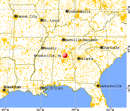
Brooksville, Alabama
Submit your own pictures of this place and show them to the world
- OSM Map
- General Map
- Google Map
- MSN Map

| Males: 2,556 | |
| Females: 2,566 |
| Median resident age: | 36.9 years |
| Alabama median age: | 35.8 years |
Zip code: 35031
| Brooksville: | $50,167 |
| AL: | $59,674 |
Estimated per capita income in 2022: $25,558 (it was $14,177 in 2000)
Brooksville CCD income, earnings, and wages data
Estimated median house or condo value in 2022: $165,920 (it was $71,300 in 2000)
| Brooksville: | $165,920 |
| AL: | $200,900 |
Mean prices in 2022: all housing units: $209,672; detached houses: $249,358; townhouses or other attached units: $218,248; mobile homes: $67,057; occupied boats, rvs, vans, etc.: $43,848
Detailed information about poverty and poor residents in Brooksville, AL
Compare current foreclosures near Brooksville, AL:
| Photo | Address | Area | Beds / Baths | Price | Details |
|---|---|---|---|---|---|

|
#1
County Road 695
Holly Pond, AL 35083
|
1,409 sq. feet
|
2 baths 3 beds |
show details | |

|
#2
Lynn St NE
Hanceville, AL 35077
|
1,344 sq. feet
|
2 baths 3 beds |
show details | |

|
#3
Hawk Ln
Blountsville, AL 35031
|
2,432 sq. feet
|
3 baths 4 beds |
show details | |

|
#4
County Road 1551
Cullman, AL 35058
|
1,320 sq. feet
|
1 baths 3 beds |
show details | |

|
#5
Anderson Dr
Cleveland, AL 35049
|
1,792 sq. feet
|
2 baths 3 beds |
show details | |

|
#6
Saylor Cir
Arab, AL 35016
|
1,785 sq. feet
|
2 baths - beds |
show details | |

|
#7
Allen Rd
Albertville, AL 35950
|
1,216 sq. feet
|
2 baths - beds |
show details | |

|
#8
Al Highway 75
Horton, AL 35980
|
1,551 sq. feet
|
1 baths - beds |
show details | |

|
#9
County Road 1592
Baileyton, AL 35019
|
1,144 sq. feet
|
1 baths - beds |
show details | |

|
#10
Fairview Cove Rd
Altoona, AL 35952
|
2,576 sq. feet
|
1 baths - beds |
show details |
| Photo | Address | Area | Beds / Baths | Price | Details |
|---|---|---|---|---|---|

|
#11
County Road 1682
Holly Pond, AL 35083
|
1,827 sq. feet
|
1 baths - beds |
show details | |

|
#12
County Road 1541
Cullman, AL 35058
|
1,878 sq. feet
|
1 baths - beds |
show details | |

|
#13
County Road 1834
Arab, AL 35016
|
1,822 sq. feet
|
1 baths - beds |
show details | |

|
#14
Vaughn Rd
Altoona, AL 35952
|
1,400 sq. feet
|
1 baths - beds |
show details | |

|
#15
County Road 1490
Cullman, AL 35058
|
1,300 sq. feet
|
1 baths - beds |
show details | |

|
#16
County Road 622
Hanceville, AL 35077
|
1,806 sq. feet
|
1 baths - beds |
show details | |

|
#17
Helen Warren Vogel St NE
Hanceville, AL 35077
|
1,352 sq. feet
|
1 baths - beds |
show details | |

|
#18
County Road 773
Cullman, AL 35055
|
7,684 sq. feet
|
2 baths - beds |
show details | |

|
#19
Al Highway 69 N
Cullman, AL 35058
|
1,598 sq. feet
|
1 baths - beds |
show details | |

|
#20
Al Highway 91
Hanceville, AL 35077
|
2,002 sq. feet
|
1 baths - beds |
show details |
| Photo | Address | Area | Beds / Baths | Price | Details |
|---|---|---|---|---|---|

|
#21
Whaley Ave NE
Hanceville, AL 35077
|
870 sq. feet
|
1 baths - beds |
show details | |

|
#22
Dean Ave NE
Hanceville, AL 35077
|
1,890 sq. feet
|
1 baths - beds |
show details | |

|
#23
Fairview Church Rd
Cleveland, AL 35049
|
1,456 sq. feet
|
- baths - beds |
show details | |

|
#24
State Highway 132
Oneonta, AL 35121
|
- sq. feet
|
- baths - beds |
show details | |

|
#25
Mobbs School Rd
Arab, AL 35016
|
- sq. feet
|
- baths - beds |
show details | |

|
#26
Nectar Cir
Cleveland, AL 35049
|
1,476 sq. feet
|
- baths - beds |
show details | |

|
#27
Hardin Rd
Guntersville, AL 35976
|
- sq. feet
|
- baths - beds |
show details | |

|
#28
69 Hwy, Lot 42
Guntersville, AL 35976
|
- sq. feet
|
- baths - beds |
show details | |

|
#29
Lindsey St
Albertville, AL 35950
|
1,539 sq. feet
|
- baths - beds |
show details | |

|
#30
Hardin Rd
Guntersville, AL 35976
|
- sq. feet
|
- baths - beds |
show details |
| Photo | Address | Area | Beds / Baths | Price | Details |
|---|---|---|---|---|---|

|
#31
County Road 1600
Cullman, AL 35058
|
- sq. feet
|
- baths - beds |
show details | |

|
#32
Summerville Rd
Boaz, AL 35957
|
- sq. feet
|
- baths - beds |
show details | |

|
#33
Timberwalk Dr
Guntersville, AL 35976
|
1,869 sq. feet
|
- baths - beds |
show details | |

|
#34
Edgehill Ln
Arab, AL 35016
|
1,245 sq. feet
|
- baths - beds |
show details | |

|
#35
Valley Rd Apt 2
Oneonta, AL 35121
|
- sq. feet
|
- baths - beds |
show details | |

|
#36
Elmore Dr
Arab, AL 35016
|
- sq. feet
|
- baths - beds |
show details | |

|
#37
Saylor Cir
Arab, AL 35016
|
1,418 sq. feet
|
- baths - beds |
show details | |

|
#38
Tidmore Ave
Oneonta, AL 35121
|
1,200 sq. feet
|
- baths - beds |
show details | |

|
#39
Gin Rd
Blountsville, AL 35031
|
- sq. feet
|
- baths - beds |
show details | |

|
#40
Pocota Dr
Oneonta, AL 35121
|
2,000 sq. feet
|
- baths - beds |
show details |
| Photo | Address | Area | Beds / Baths | Price | Details |
|---|---|---|---|---|---|

|
#41
Junkins Rd
Guntersville, AL 35976
|
- sq. feet
|
- baths - beds |
show details | |

|
#42
Lisa Ln
Arab, AL 35016
|
1,626 sq. feet
|
- baths - beds |
show details | |

|
#43
Parkwood Ln
Arab, AL 35016
|
2,540 sq. feet
|
- baths - beds |
show details | |

|
#44
Al Highway 91
Hanceville, AL 35077
|
- sq. feet
|
- baths - beds |
show details | |

|
#45
Countryside Acres Rd # 37
Cullman, AL 35058
|
- sq. feet
|
- baths - beds |
show details | |

|
#46
Countryside Acres Rd # 20
Cullman, AL 35058
|
- sq. feet
|
- baths - beds |
show details | |

|
#47
Stanfield St # 906
Altoona, AL 35952
|
- sq. feet
|
- baths - beds |
show details | |

|
#48
Northcrest Dr NW Apt 311
Cullman, AL 35058
|
- sq. feet
|
- baths - beds |
show details | |

|
#49
County Road 1555
Baileyton, AL 35019
|
- sq. feet
|
- baths - beds |
show details | |

|
Check over 1 million property listings on Foreclosure.com!
|
browse all offers | |||

- 4,43496.2%White alone
- 1413.1%Hispanic
- 180.4%Two or more races
- 100.2%American Indian alone
- 60.1%Asian alone
- 10.02%Black alone

 Recent articles from our blog. Our writers, many of them Ph.D. graduates or candidates, create easy-to-read articles on a wide variety of topics.

Current Local Time: CST time zone
Land area: 94.8 square miles.
Population density: 54 people per square mile (very low).
| Brooksville CCD: | 0.3% ($199) |
| Alabama: | 0.4% ($289) |
Nearest city with pop. 50,000+: Huntsville, AL  (38.2 miles , pop. 158,216).
Nearest city with pop. 200,000+: Birmingham, AL (47.9 miles , pop. 242,820).
Nearest city with pop. 1,000,000+: Chicago, IL (534.7 miles , pop. 2,896,016).
Nearest cities:
), ), ), )Latitude: 34.17 N, Longitude: 86.50 W
Area code commonly used in this area: 205


| Here: | 2.3% |
| Alabama: | 2.6% |

- Construction (16.4%)
- Educational services (8.5%)
- Health care (7.8%)
- Finance & insurance (4.7%)
- Agriculture, forestry, fishing & hunting (4.5%)
- Food (4.3%)
- Motor vehicle & parts dealers (3.7%)

- Construction (26.7%)
- Agriculture, forestry, fishing & hunting (6.2%)
- Truck transportation (6.1%)
- Motor vehicle & parts dealers (4.3%)
- Furniture & related product manufacturing (4.3%)
- Metal & metal products (3.8%)
- Food (3.5%)

- Health care (16.7%)
- Educational services (16.5%)
- Finance & insurance (8.7%)
- Food (5.3%)
- Apparel (5.3%)
- Food & beverage stores (4.1%)
- Motor vehicle & parts dealers (3.0%)

- Other sales and related occupations, including supervisors (6.4%)
- Other production occupations, including supervisors (5.9%)
- Driver/sales workers and truck drivers (5.1%)
- Other office and administrative support workers, including supervisors (4.9%)
- Construction traders workers except carpenters, electricians, painters, plumbers, and construction laborers (4.1%)
- Metal workers and plastic workers (4.0%)
- Material recording, scheduling, dispatching, and distributing workers (3.2%)

- Driver/sales workers and truck drivers (8.3%)
- Other sales and related occupations, including supervisors (7.7%)
- Construction traders workers except carpenters, electricians, painters, plumbers, and construction laborers (7.1%)
- Metal workers and plastic workers (6.2%)
- Building and grounds cleaning and maintenance occupations (4.9%)
- Other production occupations, including supervisors (4.8%)
- Electrical equipment mechanics and other installation, maintenance, and repair workers, including supervisors (4.4%)

- Other office and administrative support workers, including supervisors (8.9%)
- Other production occupations, including supervisors (7.4%)
- Information and record clerks, except customer service representatives (5.3%)
- Material recording, scheduling, dispatching, and distributing workers (5.2%)
- Preschool, kindergarten, elementary, and middle school teachers (4.8%)
- Other sales and related occupations, including supervisors (4.8%)
- Postsecondary teachers (4.3%)
Average climate in Brooksville, Alabama
Based on data reported by over 4,000 weather stations


Tornado activity:
Brooksville-area historical tornado activity is slightly above Alabama state average. It is 174% greater than the overall U.S. average.
On 3/11/1963, a category F4 (max. wind speeds 207-260 mph) tornado 3.2 miles away from the Brooksville place center killed 2 people and injured 6 people and caused between $500,000 and $5,000,000 in damages.
On 11/18/1957, a category F4 tornado 13.0 miles away from the place center killed 3 people and injured 12 people and caused between $50,000 and $500,000 in damages.
Earthquake activity:
Brooksville-area historical earthquake activity is significantly above Alabama state average. It is 141% greater than the overall U.S. average.On 4/29/2003 at 08:59:39, a magnitude 4.9 (4.4 MB, 4.6 MW, 4.9 LG, Class: Light, Intensity: IV - V) earthquake occurred 54.5 miles away from Brooksville center
On 1/18/1999 at 07:00:53, a magnitude 4.8 (4.8 MB, 4.0 LG, Depth: 0.6 mi) earthquake occurred 68.3 miles away from Brooksville center
On 4/29/2003 at 08:59:39, a magnitude 4.6 (4.6 MW, Depth: 12.3 mi) earthquake occurred 54.5 miles away from the city center
On 6/24/1975 at 11:11:36, a magnitude 4.5 (4.5 MB) earthquake occurred 83.0 miles away from the city center
On 4/18/2008 at 09:36:59, a magnitude 5.4 (5.1 MB, 4.8 MS, 5.4 MW, 5.2 MW, Class: Moderate, Intensity: VI - VII) earthquake occurred 306.4 miles away from Brooksville center
On 10/24/1997 at 08:35:17, a magnitude 4.9 (4.8 MB, 4.2 MS, 4.9 LG, Depth: 6.2 mi) earthquake occurred 215.3 miles away from the city center
Magnitude types: regional Lg-wave magnitude (LG), body-wave magnitude (MB), surface-wave magnitude (MS), moment magnitude (MW)
Natural disasters:
The number of natural disasters in Blount County (21) is greater than the US average (15).Major Disasters (Presidential) Declared: 12
Emergencies Declared: 5
Causes of natural disasters: Storms: 14, Floods: 10, Tornadoes: 10, Winds: 5, Hurricanes: 3, Drought: 1, Snowfall: 1, Winter Storm: 1, Other: 1 (Note: some incidents may be assigned to more than one category).
Hospitals and medical centers near Brooksville:
- ALTOONA HEALTH AND REHAB (Nursing Home, about 14 miles away; ALTOONA, AL)
- TLC NURSING CENTER (Nursing Home, about 15 miles away; ONEONTA, AL)
- MARSHALL MANOR NURSING HOME (Nursing Home, about 15 miles away; GUNTERSVILLE, AL)
- GOLDEN LIVING CENTER - ONEONTA (Nursing Home, about 16 miles away; ONEONTA, AL)
- AMEDISYS HOME HEALTH OF BLOUNTSVILLE (Home Health Center, about 16 miles away; ONEONTA, AL)
- CARE FIRST HOME HEALTH OF BLOUNT COUNTY (Home Health Center, about 16 miles away; ONEONTA, AL)
Colleges/universities with over 2000 students nearest to Brooksville:
- George C Wallace State Community College-Hanceville (about 18 miles; Hanceville, AL; Full-time enrollment: 4,486)
- Snead State Community College (about 19 miles; Boaz, AL; FT enrollment: 2,023)
- Gadsden State Community College (about 32 miles; Gadsden, AL; FT enrollment: 4,650)
- Jefferson State Community College (about 38 miles; Birmingham, AL; FT enrollment: 6,041)
- University of Alabama in Huntsville (about 40 miles; Huntsville, AL; FT enrollment: 6,006)
- John C Calhoun State Community College (about 43 miles; Tanner, AL; FT enrollment: 7,911)
- Northeast Alabama Community College (about 43 miles; Rainsville, AL; FT enrollment: 2,409)
Points of interest:
Notable locations in Brooksville: Lakeview Farms (A), Scofield Poultry Farm (B), Mount View (C), Rainbow Crossing (D), Royal Community Volunteer Fire Department (E), Summit Volunteer Fire and Rescue (F), Brooksville Volunteer Fire and Rescue (G). Display/hide their locations on the map
Churches in Brooksville include: New Prospect Church (A), Pleasant Hill Church (B), Pleasant Valley Church (C), Roswell Creek Church (D), Shady Grove Church (E), Antioch Baptist Church (F), Bethlehem Church (G), New Lebanon Southern Methodist Church (H), Mount Hebron Church (I). Display/hide their locations on the map
Cemeteries: Cox Cemetery (1), Dickson Cemetery (2), Sivley Cemetery (3), Ebell Cemetery (4), Alldredge Cemetery (5), Summit Cemetery (6), Gibbs Chapel Cemetery (7). Display/hide their locations on the map
Reservoirs: Moman Lake (A), Spradlin Pond (B), Osborne Lake (C), Curtis Williams Upper Lake (D), Curtis Williams Lake (E). Display/hide their locations on the map
Streams, rivers, and creeks: Roswell Creek (A), Pond Branch (B), Mud Creek (C), Mill Branch (D), Honey Branch (E), Holland Branch (F), Camp Branch (G), Buzzard Branch (H), Booker Branch (I). Display/hide their locations on the map
| This place: | 2.6 people |
| Alabama: | 2.5 people |
| This place: | 73.0% |
| Whole state: | 67.8% |
| This place: | 4.9% |
| Whole state: | 4.7% |
Likely homosexual households (counted as self-reported same-sex unmarried-partner households)
- Lesbian couples: 0.5% of all households
- Gay men: 0.3% of all households
| This place: | 16.3% |
| Whole state: | 16.1% |
| This place: | 6.0% |
| Whole state: | 7.3% |
For population 15 years and over in Brooksville:

- Never married: 15.5%
- Now married: 68.7%
- Separated: 1.8%
- Widowed: 5.1%
- Divorced: 10.7%
For population 25 years and over in Brooksville:
- High school or higher: 63.5%
- Bachelor's degree or higher: 6.6%
- Graduate or professional degree: 1.9%
- Unemployed: 10.0%
- Mean travel time to work (commute): 30.9 minutes


| Here: | 13.6 |
| Alabama average: | 13.2 |
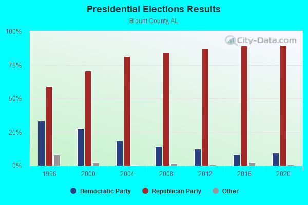
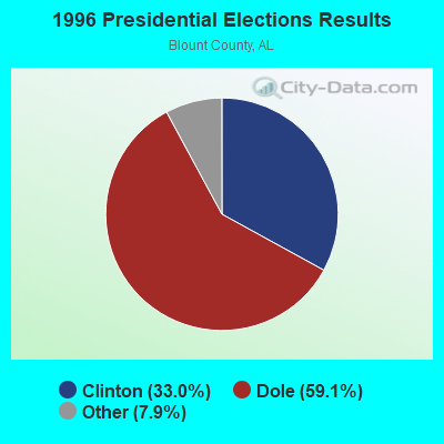
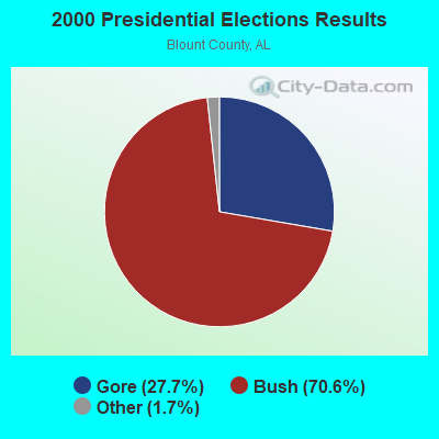
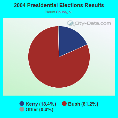
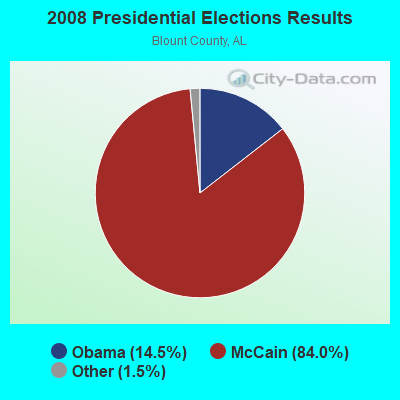
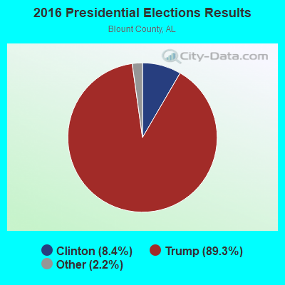
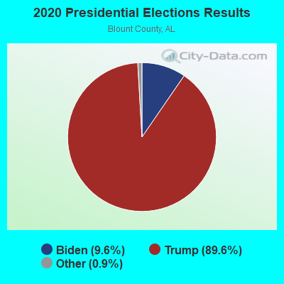
Graphs represent county-level data. Detailed 2008 Election Results
Religion statistics for Brooksville, AL (based on Blount County data)
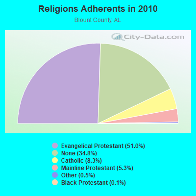
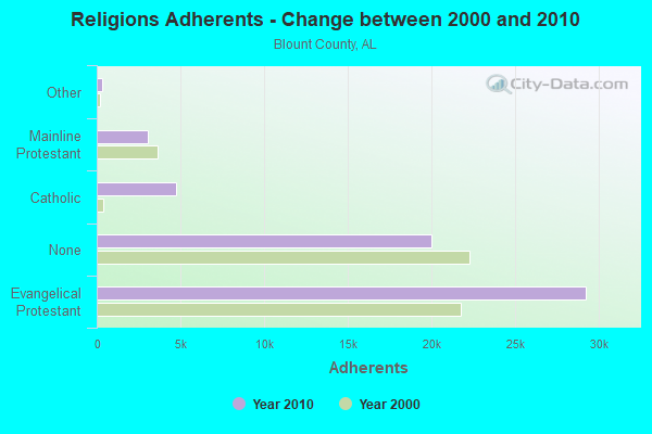
| Religion | Adherents | Congregations |
|---|---|---|
| Evangelical Protestant | 29,223 | 122 |
| Catholic | 4,744 | 1 |
| Mainline Protestant | 3,035 | 29 |
| Other | 292 | 2 |
| Black Protestant | 58 | 2 |
| None | 19,970 | - |
Food Environment Statistics:
| Blount County: | 1.06 / 10,000 pop. |
| State: | 1.89 / 10,000 pop. |
| Blount County: | 0.18 / 10,000 pop. |
| Alabama: | 0.20 / 10,000 pop. |
| Blount County: | 0.18 / 10,000 pop. |
| Alabama: | 0.65 / 10,000 pop. |
| Blount County: | 5.13 / 10,000 pop. |
| State: | 6.32 / 10,000 pop. |
| This county: | 2.48 / 10,000 pop. |
| Alabama: | 5.75 / 10,000 pop. |
| Blount County: | 10.5% |
| Alabama: | 11.8% |
| Here: | 31.5% |
| State: | 31.7% |
| Blount County: | 19.9% |
| Alabama: | 13.5% |
Strongest AM radio stations in Brooksville:
- WDJC (850 AM; 50 kW; BIRMINGHAM, AL; Owner: KIMTRON, INC.)
- WNSI (810 AM; 50 kW; JACKSONVILLE, AL; Owner: UNITED BROADCASTING NETWORK, INC.)
- WJOX (690 AM; 50 kW; BIRMINGHAM, AL; Owner: CITADEL BROADCASTING COMPANY)
- WAPI (1070 AM; 50 kW; BIRMINGHAM, AL; Owner: CITADEL BROADCASTING COMPANY)
- WLOR (1550 AM; 50 kW; HUNTSVILLE, AL; Owner: BCA RADIO, LLC)
- WWAM (820 AM; daytime; 50 kW; JASPER, TN; Owner: SHELTON BROADCASTING SYSTEM)
- WAAX (570 AM; 5 kW; GADSDEN, AL; Owner: CAPSTAR TX LIMITED PARTNERSHIP)
- WKNG (1060 AM; daytime; 50 kW; TALLAPOOSA, GA; Owner: WKNG, INC.)
- WMCJ (1460 AM; 5 kW; CULLMAN, AL)
- WCRL (1570 AM; 2 kW; ONEONTA, AL; Owner: BLOUNT COUNTY BROADCASTING SERVICE, INC.)
- WJBY (930 AM; 5 kW; RAINBOW CITY, AL; Owner: GADSDEN BROADCASTING COMPANY, INC.)
- WFLI (1070 AM; 50 kW; LOOKOUT MOUNTAIN, TN; Owner: WFLI, INC.)
- WGAD (1350 AM; 5 kW; GADSDEN, AL; Owner: DEKALB COUNTY COMMUNITY RADIO, INC.)
Strongest FM radio stations in Brooksville:
- WYDE-FM (101.1 FM; CULLMAN, AL; Owner: KIMTRON, INC.)
- WAFN-FM (92.7 FM; ARAB, AL; Owner: FUN MEDIA GROUP, INC.)
- WRSA-FM (96.9 FM; DECATUR, AL; Owner: NCA, INC.)
- WRAX (107.7 FM; BIRMINGHAM, AL; Owner: CITADEL BROADCASTING COMPANY)
- WQSB (105.1 FM; ALBERTVILLE, AL; Owner: SAND MOUNTAIN BROADCASTING SERVICE, INC.)
- WKXX (102.9 FM; ATTALLA, AL; Owner: BROADCAST MEDIA LLC)
- WFMH-FM (95.5 FM; HOLLY POND, AL; Owner: VOICE OF CULLMAN, L.L.C.)
- WTWX-FM (95.9 FM; GUNTERSVILLE, AL; Owner: GUNTERSVILLE BROADCASTING CO., INC.)
- WAHR (99.1 FM; HUNTSVILLE, AL; Owner: BCA RADIO, LLC)
- WKUL (92.1 FM; CULLMAN, AL; Owner: JONATHAN CHRISTIAN CORP.)
- W289AC (105.7 FM; HUNTSVILLE, AL; Owner: WILLIAM PAXTON ROGERS)
- WKLD (97.7 FM; ONEONTA, AL; Owner: BLOUNT COUNTY BROADCASTING SERVICE INC.)
- W298AF (107.5 FM; HADEN, AL; Owner: HADEN RADIO COMPANY)
- WRHY (105.9 FM; CENTRE, AL; Owner: WILLIAMS COMMUNICATIONS, INC.)
- WXQW (94.1 FM; MERIDIANVILLE, AL; Owner: CAPSTAR TX LIMITED PARTNERSHIP)
- W293AH (106.5 FM; NORMAL, AL; Owner: CAPSTAR TX LIMITED PARTNERSHIP)
- WLRH (89.3 FM; HUNTSVILLE, AL; Owner: ALABAMA EDUCATIONAL TELEVISION COMMISSION)
- WTAK-FM (106.1 FM; HARTSELLE, AL; Owner: CAPSTAR TX LIMITED PARTNERSHIP)
- WRJL-FM (99.9 FM; EVA, AL; Owner: ROJO, INC.)
- WJIA (88.5 FM; GUNTERSVILLE, AL; Owner: LAKE CITY EDUCATIONAL B/CASTING INC.)
TV broadcast stations around Brooksville:
- WPXH (Channel 44; GADSDEN, AL; Owner: PAXSON COMMUNICATIONS LICENSE COMPANY, LLC)
- WZDX (Channel 54; HUNTSVILLE, AL; Owner: HUNTSVILLE TELEVISION ACQUISITION CORP.)
- WTJP (Channel 60; GADSDEN, AL; Owner: TRINITY BROADCASTING NETWORK)
- WAAY-TV (Channel 31; HUNTSVILLE, AL; Owner: PIEDMONT TELEVISION OF HUNTSVILLE LICENSE LLC)
- WHNT-TV (Channel 19; HUNTSVILLE, AL; Owner: NEW YORK TIMES MANAGEMENT SERVICES)
- WCQT-LP (Channel 52; CULLMAN, AL; Owner: FIRST CULLMAN BROADCASTING, INC.)
FCC Registered Antenna Towers:
5- David H Fain, Brooksville (Lat: 34.161194 Lon: -86.496556), Type: 76.2, Overall height: 76.2 m, Registrant: Belle Tower, LLC, Belletwr99@aol.Com, , Gaine-sville, Phone: (770) 297-6700
- David H Fain, Brooksville (Lat: 34.161194 Lon: -86.496556), Type: 76.2, Overall height: 76.2 m, Registrant: Belle Tower, LLC, Belletwr99@aol.Com, , Gaine-sville, Phone: (770) 297-6700
- TOM H GRAY, Brooksville (Lat: 34.161194 Lon: -86.496556), Type: 76.2, Overall height: 76.2 m, Registrant: Sba Towers Ii LLC, Eroach@sbasite.Com, , Boca -Raton, Phone: (561) 995-7670
- Carrie Kirk, Brooksville (Lat: 34.161194 Lon: -86.496556), Type: 76.2, Overall height: 76.2 m, Registrant: Towercom Atlanta, LLC, Jbrown@towercomenterprises.Com, , Jacks-onville, Phone: (904) 880-8887
- Edward G Roach, Brooksville (Lat: 34.161194 Lon: -86.496556), Type: 76.2, Overall height: 76.2 m, Registrant: Towercom Atlanta, LLC, Jbrown@towercomenterprises.Com, , Jacks-onville, Phone: (904) 880-8887
FCC Registered Microwave Towers:
3- BROOKSVILLE, Brooksville (Lat: 34.161222 Lon: -86.496583), Type: Ltower, Structure height: 76.2 m, Call Sign: WQXF402,
Assigned Frequencies: 11385.0 MHz, 11425.0 MHz, 11385.0 MHz, 11425.0 MHz, 11385.0 MHz, 11425.0 MHz, 11385.0 MHz, 11425.0 MHz, 11385.0 MHz, 11425.0 MHz... (+22 more), Grant Date: 02/18/2016, Expiration Date: 02/18/2026, Certifier: Larry F Butts, Registrant: Southern Company Services, 600 N. 18th St / Bin 5n-5409, Birmingham, AL 35203, Phone: (205) 257-7600, Fax: (205) 257-2134, Email:
- BROOKSVILLE, 1.5 Mi Nw Brooksville (Lat: 34.516194 Lon: -86.836667), Type: Tower, Structure height: 45.7 m, Call Sign: KZH28,
Assigned Frequencies: 7050.00 MHz, Grant Date: 08/03/1999, Expiration Date: 04/01/2029, Registrant: Kessler And Gehman Associates, Inc., 507 Nw 60th Street, Suite C, Gainesville, FL 32607-2702, Phone: (352) 332-3157, Fax: (352) 332-6392, Email:
- BROOKSVILLE, 1.5 Mi Nw Brooksville (Lat: 34.516194 Lon: -86.836667), Type: Tower, Structure height: 45.7 m, Call Sign: KZH29,
Assigned Frequencies: 7100.00 MHz, Grant Date: 08/03/1999, Expiration Date: 04/01/2029, Registrant: Kessler And Gehman Associates, Inc., 507 Nw 60th Street, Suite C, Gainesville, FL 32607-2702, Phone: (352) 332-3157, Fax: (352) 332-6392, Email:

- 46.7%Bottled, tank, or LP gas
- 42.4%Electricity
- 6.4%Utility gas
- 2.9%Wood
- 1.2%Other fuel
- 0.5%Coal or coke

- 72.3%Bottled, tank, or LP gas
- 25.4%Electricity
- 2.3%Utility gas
Brooksville compared to Alabama state average:
- Black race population percentage significantly below state average.
- Median age below state average.
- Foreign-born population percentage significantly below state average.
- Length of stay since moving in significantly above state average.
- Number of rooms per house significantly below state average.
- House age significantly below state average.
- Percentage of population with a bachelor's degree or higher significantly below state average.
Brooksville on our top lists:
- #1 on the list of "Top 101 cities with largest percentage of females in industries: retail florists (population 5,000+)"
- #6 on the list of "Top 101 cities with largest percentage of females in industries: apparel, fabrics, and notions merchant wholesalers (population 5,000+)"
- #8 on the list of "Top 101 cities with largest percentage of females in industries: motor vehicle and parts dealers (population 5,000+)"
- #11 on the list of "Top 101 cities with largest percentage of males in industries: furniture and related product manufacturing (population 5,000+)"
- #11 on the list of "Top 101 cities with largest percentage of females in occupations: postsecondary teachers (population 5,000+)"
- #12 on the list of "Top 101 cities with largest percentage of females in occupations: occupational and physical therapist assistants and aides (population 5,000+)"
- #12 on the list of "Top 101 cities with largest percentage of males in industries: apparel (population 5,000+)"
- #13 on the list of "Top 101 cities with largest percentage of females in industries: food (population 5,000+)"
- #14 on the list of "Top 101 cities with largest percentage of females in industries: apparel (population 5,000+)"
- #15 on the list of "Top 101 cities with largest percentage of females in industries: warehousing and storage (population 5,000+)"
- #17 on the list of "Top 101 cities with largest percentage of males in industries: farm supplies merchant wholesalers (population 5,000+)"
- #19 on the list of "Top 101 cities with largest percentage of females in industries: miscellaneous durable goods merchant wholesalers (population 5,000+)"
- #21 on the list of "Top 101 cities with largest percentage of males in industries: building material and garden equipment and supplies dealers (population 5,000+)"
- #24 on the list of "Top 101 cities with largest percentage of males in occupations: construction trades workers except carpenters, electricians, painters, plumbers, and construction laborers (population 5,000+)"
- #25 on the list of "Top 101 cities with largest percentage of females in occupations: farmers and farm managers (population 5,000+)"
- #26 on the list of "Top 101 cities with largest percentage of females in occupations: material recording, scheduling, dispatching, and distributing workers (population 5,000+)"
- #28 on the list of "Top 101 cities with largest percentage of females in occupations: other production occupations including supervisors (population 5,000+)"
- #37 on the list of "Top 101 cities with largest percentage of males in industries: truck transportation (population 5,000+)"
- #46 on the list of "Top 101 cities with largest percentage of females in industries: electrical equipment, appliances, and components (population 5,000+)"
- #58 on the list of "Top 101 cities with largest percentage of males in industries: food (population 5,000+)"
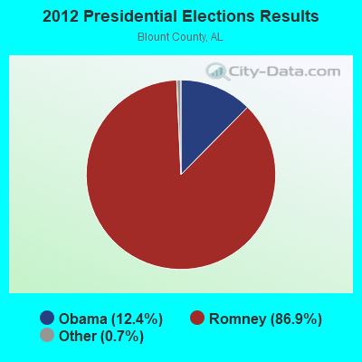
- #48 on the list of "Top 101 counties with highest percentage of residents voting for Romney (Republican) in the 2012 Presidential Election"