Chrisney, Indiana
Submit your own pictures of this town and show them to the world
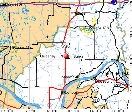
- OSM Map
- General Map
- Google Map
- MSN Map
Population change since 2000: -14.0%
 |
| Males: 204 | |
| Females: 264 |
| Median resident age: | 38.2 years |
| Indiana median age: | 38.2 years |
Zip codes: 47611.
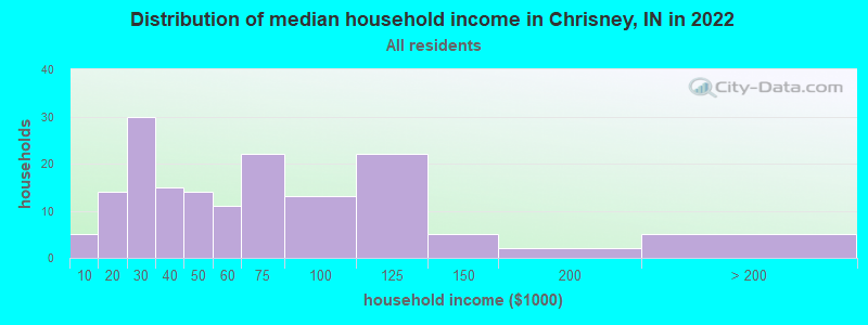
| Chrisney: | $49,090 |
| IN: | $66,785 |
Estimated per capita income in 2022: $23,125 (it was $14,127 in 2000)
Chrisney town income, earnings, and wages data
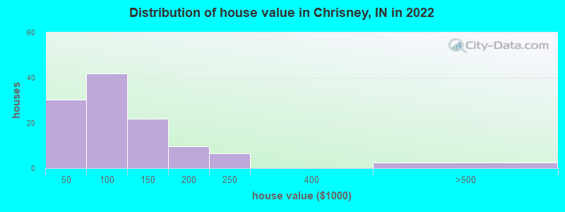
Estimated median house or condo value in 2022: $101,054 (it was $60,300 in 2000)
| Chrisney: | $101,054 |
| IN: | $208,700 |
Mean prices in 2022: all housing units: $103,536; detached houses: $110,128; mobile homes: $42,431
Median gross rent in 2022: $475.
Detailed information about poverty and poor residents in Chrisney, IN
Compare current foreclosures near Chrisney, IN:
| Photo | Address | Area | Beds / Baths | Price | Details |
|---|---|---|---|---|---|

|
#1
S Main St
Chrisney, IN 47611
|
- sq. feet
|
- baths - beds |
show details | |

|
#2
S 8th St
Boonville, IN 47601
|
990 sq. feet
|
1 baths 2 beds |
$129,900
|
show details |

|
#3
N 5th St
Boonville, IN 47601
|
1,296 sq. feet
|
1 baths 3 beds |
show details | |

|
#4
10th St
Tell City, IN 47586
|
3,216 sq. feet
|
2 baths 3 beds |
show details | |

|
#5
W Carpenter Ave
Rockport, IN 47635
|
1,107 sq. feet
|
1 baths 3 beds |
show details | |

|
#6
18th St
Tell City, IN 47586
|
1,800 sq. feet
|
2 baths 4 beds |
show details | |

|
#7
22nd St
Tell City, IN 47586
|
1,110 sq. feet
|
2 baths 2 beds |
show details | |

|
#8
E Oak St
Boonville, IN 47601
|
1,368 sq. feet
|
1 baths 3 beds |
show details | |

|
#9
N Lincoln Ave
Rockport, IN 47635
|
1,120 sq. feet
|
1 baths 3 beds |
show details | |

|
#10
20th St
Tell City, IN 47586
|
1,092 sq. feet
|
1 baths 3 beds |
show details |
| Photo | Address | Area | Beds / Baths | Price | Details |
|---|---|---|---|---|---|

|
#11
N 7th St
Boonville, IN 47601
|
1,171 sq. feet
|
1 baths 3 beds |
show details | |

|
#12
E Chestnut St
Boonville, IN 47601
|
936 sq. feet
|
2 baths 3 beds |
show details | |

|
#13
Terrace Ave
Tell City, IN 47586
|
1,080 sq. feet
|
1 baths 3 beds |
show details | |

|
#14
Rose Ln
Grandview, IN 47615
|
1,404 sq. feet
|
2 baths 3 beds |
show details | |

|
#15
10th St
Tell City, IN 47586
|
2,024 sq. feet
|
3 baths 3 beds |
show details | |

|
#16
13th St
Tell City, IN 47586
|
962 sq. feet
|
1 baths 2 beds |
show details | |

|
#17
12th St
Tell City, IN 47586
|
1,435 sq. feet
|
1 baths 3 beds |
show details | |

|
#18
Candy Rd
Saint Meinrad, IN 47577
|
1,685 sq. feet
|
1 baths 2 beds |
show details | |

|
#19
Sturbridge Pl
Owensboro, KY 42303
|
1,300 sq. feet
|
1 baths 3 beds |
show details | |

|
#20
Tower Dr
Boonville, IN 47601
|
1,578 sq. feet
|
1 baths 2 beds |
show details |
| Photo | Address | Area | Beds / Baths | Price | Details |
|---|---|---|---|---|---|

|
#21
W County Road 150 N
Richland, IN 47634
|
1,040 sq. feet
|
1 baths 2 beds |
show details | |

|
#22
E Walnut St
Boonville, IN 47601
|
1,792 sq. feet
|
2 baths 3 beds |
show details | |

|
#23
12th St
Tell City, IN 47586
|
1,680 sq. feet
|
1 baths 3 beds |
show details | |

|
#24
S 8th St
Boonville, IN 47601
|
1,616 sq. feet
|
1 baths 3 beds |
show details | |

|
#25
E Oak St
Boonville, IN 47601
|
1,792 sq. feet
|
1 baths 3 beds |
show details | |

|
#26
E Poplar St
Boonville, IN 47601
|
1,729 sq. feet
|
1 baths 2 beds |
show details | |

|
#27
10th St
Tell City, IN 47586
|
1,664 sq. feet
|
1 baths 2 beds |
show details | |

|
#28
W Walnut St
Boonville, IN 47601
|
864 sq. feet
|
1 baths 2 beds |
show details | |

|
#29
Pestalozzi St
Tell City, IN 47586
|
780 sq. feet
|
1 baths 2 beds |
show details | |

|
#30
13th St
Tell City, IN 47586
|
1,288 sq. feet
|
1 baths 4 beds |
show details |
| Photo | Address | Area | Beds / Baths | Price | Details |
|---|---|---|---|---|---|

|
#31
S 7th St
Boonville, IN 47601
|
1,341 sq. feet
|
1 baths 2 beds |
show details | |

|
#32
Scott Ct
Owensboro, KY 42303
|
1,189 sq. feet
|
1 baths 3 beds |
show details | |

|
#33
Sutter Loop E
Owensboro, KY 42303
|
1,014 sq. feet
|
1 baths 3 beds |
show details | |

|
#34
Graham Ln E
Owensboro, KY 42303
|
1,441 sq. feet
|
1 baths 3 beds |
show details | |

|
#35
14th St
Tell City, IN 47586
|
2,444 sq. feet
|
1 baths 2 beds |
show details | |

|
#36
W Sycamore St
Boonville, IN 47601
|
1,564 sq. feet
|
1 baths 4 beds |
show details | |

|
#37
W Walnut St
Boonville, IN 47601
|
1,389 sq. feet
|
1 baths 2 beds |
show details | |

|
#38
E Oak St
Boonville, IN 47601
|
1,980 sq. feet
|
1 baths 4 beds |
show details | |

|
#39
Main St
Tell City, IN 47586
|
1,680 sq. feet
|
1 baths 2 beds |
show details | |

|
#40
Jim Haaff Blvd
Rockport, IN 47635
|
1,369 sq. feet
|
1 baths 3 beds |
show details |
| Photo | Address | Area | Beds / Baths | Price | Details |
|---|---|---|---|---|---|

|
#41
Sand Hill Rd
Lewisport, KY 42351
|
970 sq. feet
|
1 baths 2 beds |
show details | |

|
#42
Meadowlane Dr
Lewisport, KY 42351
|
1,228 sq. feet
|
1 baths 3 beds |
show details | |

|
#43
Maple Heights Ave
Owensboro, KY 42303
|
840 sq. feet
|
1 baths 2 beds |
show details | |

|
#44
Pell St
Lewisport, KY 42351
|
864 sq. feet
|
1 baths 3 beds |
show details | |

|
#45
Tell St
Tell City, IN 47586
|
1,372 sq. feet
|
1 baths 3 beds |
show details | |

|
#46
Williamson St
Rockport, IN 47635
|
1,891 sq. feet
|
1 baths 3 beds |
show details | |

|
#47
Walnut St
Rockport, IN 47635
|
1,080 sq. feet
|
1 baths 2 beds |
show details | |

|
#48
S 2nd St
Rockport, IN 47635
|
3,520 sq. feet
|
2 baths 4 beds |
show details | |

|
#49
S Balthazar Dr
Santa Claus, IN 47579
|
1,853 sq. feet
|
1 baths 3 beds |
show details | |

|
Check over 1 million property listings on Foreclosure.com!
|
browse all offers | |||


- 42996.2%White alone
- 71.6%Hispanic
- 30.7%Two or more races
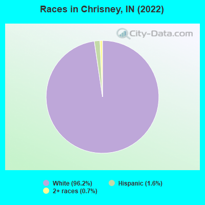
Races in Chrisney detailed stats: ancestries, foreign born residents, place of birth
 Recent articles from our blog. Our writers, many of them Ph.D. graduates or candidates, create easy-to-read articles on a wide variety of topics.


 | Thinking about moving to Indiana from California (18 replies) |
Latest news from Chrisney, IN collected exclusively by city-data.com from local newspapers, TV, and radio stations
Ancestries: German (39.2%), English (16.9%), American (8.2%), Eastern European (7.1%), Irish (3.9%), Scotch-Irish (2.7%).
Current Local Time: CST time zone
Elevation: 441 feet
Land area: 0.37 square miles.
Population density: 1,277 people per square mile (low).
2 residents are foreign born
| This town: | 0.4% |
| Indiana: | 5.6% |
Median real estate property taxes paid for housing units with mortgages in 2022: $558 (0.5%)
Median real estate property taxes paid for housing units with no mortgage in 2022: $399 (0.4%)
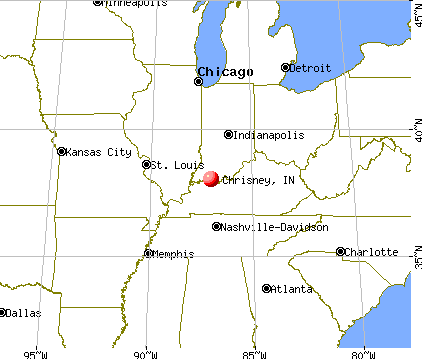
Nearest city with pop. 50,000+: Owensboro, KY  (18.3 miles , pop. 54,067).
Nearest city with pop. 200,000+: Louisville, KY (71.5 miles , pop. 256,231).
Nearest city with pop. 1,000,000+: Chicago, IL (266.9 miles , pop. 2,896,016).
Nearest cities:
), ), ), ), ), Latitude: 38.01 N, Longitude: 87.04 W
Area code: 812

| Here: | 2.8% |
| Indiana: | 2.8% |
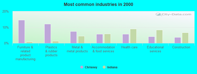
- Furniture & related product manufacturing (14.5%)
- Plastics & rubber products (12.0%)
- Metal & metal products (7.5%)
- Accommodation & food services (5.8%)
- Health care (5.8%)
- Educational services (4.1%)
- Construction (3.7%)
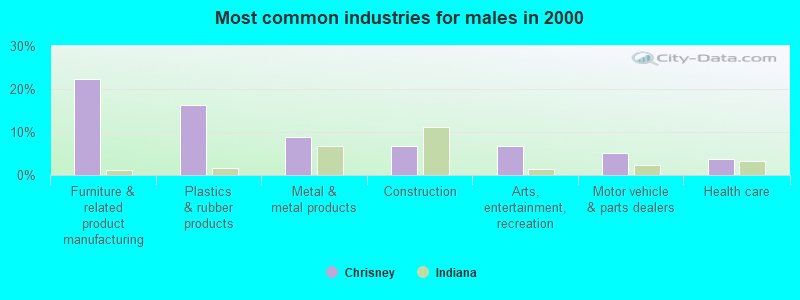
- Furniture & related product manufacturing (22.2%)
- Plastics & rubber products (16.3%)
- Metal & metal products (8.9%)
- Construction (6.7%)
- Arts, entertainment, recreation (6.7%)
- Motor vehicle & parts dealers (5.2%)
- Health care (3.7%)
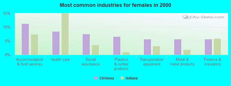
- Accommodation & food services (11.3%)
- Health care (8.5%)
- Social assistance (7.5%)
- Plastics & rubber products (6.6%)
- Transportation equipment (5.7%)
- Metal & metal products (5.7%)
- Finance & insurance (5.7%)
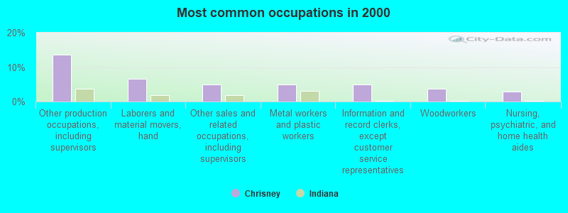
- Other production occupations, including supervisors (13.7%)
- Laborers and material movers, hand (6.6%)
- Other sales and related occupations, including supervisors (5.0%)
- Metal workers and plastic workers (5.0%)
- Information and record clerks, except customer service representatives (5.0%)
- Woodworkers (3.7%)
- Nursing, psychiatric, and home health aides (2.9%)
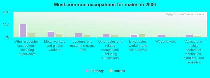
- Other production occupations, including supervisors (21.5%)
- Metal workers and plastic workers (8.9%)
- Laborers and material movers, hand (6.7%)
- Other sales and related occupations, including supervisors (5.2%)
- Driver/sales workers and truck drivers (4.4%)
- Woodworkers (4.4%)
- Vehicle and mobile equipment mechanics, installers, and repairers (4.4%)

- Information and record clerks, except customer service representatives (11.3%)
- Laborers and material movers, hand (6.6%)
- Nursing, psychiatric, and home health aides (4.7%)
- Other sales and related occupations, including supervisors (4.7%)
- Customer service representatives (4.7%)
- Cooks and food preparation workers (3.8%)
- Building and grounds cleaning and maintenance occupations (3.8%)
Average climate in Chrisney, Indiana
Based on data reported by over 4,000 weather stations


(lower is better)
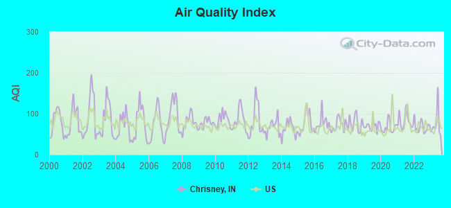
Air Quality Index (AQI) level in 2023 was 75.4. This is about average.
| City: | 75.4 |
| U.S.: | 72.6 |
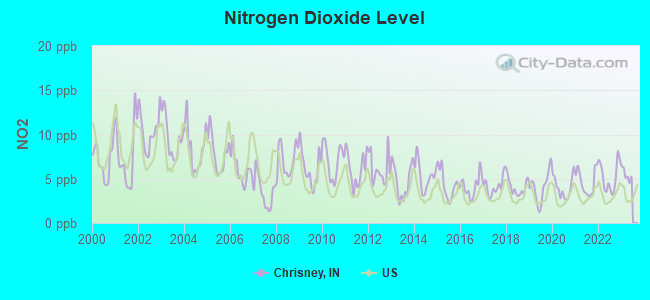
Nitrogen Dioxide (NO2) [ppb] level in 2022 was 5.21. This is about average. Closest monitor was 2.3 miles away from the city center.
| City: | 5.21 |
| U.S.: | 5.11 |
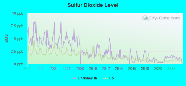
Sulfur Dioxide (SO2) [ppb] level in 2023 was 0.964. This is significantly better than average. Closest monitor was 9.0 miles away from the city center.
| City: | 0.964 |
| U.S.: | 1.515 |
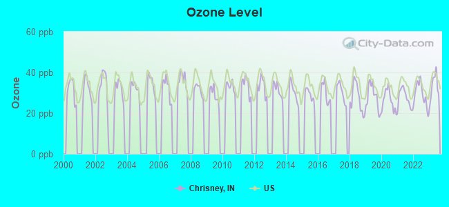
Ozone [ppb] level in 2023 was 32.8. This is about average. Closest monitor was 13.5 miles away from the city center.
| City: | 32.8 |
| U.S.: | 33.3 |
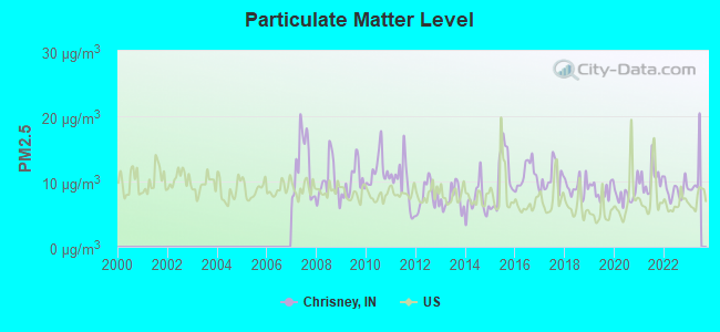
Particulate Matter (PM2.5) [µg/m3] level in 2022 was 8.69. This is about average. Closest monitor was 11.0 miles away from the city center.
| City: | 8.69 |
| U.S.: | 8.11 |
Tornado activity:
Chrisney-area historical tornado activity is slightly below Indiana state average. It is 55% greater than the overall U.S. average.
On 4/3/1974, a category F5 (max. wind speeds 261-318 mph) tornado 16.0 miles away from the Chrisney town center killed 6 people and injured 86 people and caused between $50,000,000 and $500,000,000 in damages.
On 4/3/1974, a category F5 tornado 33.9 miles away from the town center killed 31 people and injured 270 people and caused between $500,000 and $5,000,000 in damages.
Earthquake activity:
Chrisney-area historical earthquake activity is significantly above Indiana state average. It is 178% greater than the overall U.S. average.On 4/18/2008 at 09:36:59, a magnitude 5.4 (5.1 MB, 4.8 MS, 5.4 MW, 5.2 MW, Class: Moderate, Intensity: VI - VII) earthquake occurred 55.3 miles away from the city center
On 4/18/2008 at 09:36:59, a magnitude 5.2 (5.2 MW, Depth: 8.9 mi) earthquake occurred 55.3 miles away from Chrisney center
On 6/18/2002 at 17:37:15, a magnitude 5.0 (4.3 MB, 4.6 MW, 5.0 LG) earthquake occurred 40.6 miles away from the city center
On 6/10/1987 at 23:48:54, a magnitude 5.1 (4.9 MB, 4.4 MS, 4.6 MS, 5.1 LG) earthquake occurred 72.4 miles away from the city center
On 4/18/2008 at 15:14:16, a magnitude 4.8 (4.5 MB, 4.8 MW, 4.6 MW, Class: Light, Intensity: IV - V) earthquake occurred 54.5 miles away from Chrisney center
On 4/18/2008 at 15:14:17, a magnitude 4.7 (4.7 MW, Depth: 9.6 mi) earthquake occurred 54.7 miles away from Chrisney center
Magnitude types: regional Lg-wave magnitude (LG), body-wave magnitude (MB), surface-wave magnitude (MS), moment magnitude (MW)
Natural disasters:
The number of natural disasters in Spencer County (13) is near the US average (15).Major Disasters (Presidential) Declared: 9
Emergencies Declared: 2
Causes of natural disasters: Floods: 8, Storms: 7, Tornadoes: 3, Blizzard: 1, Hurricane: 1, Snow: 1, Wind: 1, Winter Storm: 1, Other: 1 (Note: some incidents may be assigned to more than one category).

Hospitals and medical centers near Chrisney:
- MILLER'S MERRY MANOR (Nursing Home, about 9 miles away; ROCKPORT, IN)
- SPENCER COUNTY HOSPICE INC (Hospital, about 10 miles away; ROCKPORT, IN)
- WOODMONT HEALTH CAMPUS (Nursing Home, about 12 miles away; BOONVILLE, IN)
- CORE OF HUNTINGBURG INC (Nursing Home, about 12 miles away; DALE, IN)
- TRINITY BEND LIVING CENTER (Nursing Home, about 12 miles away; DALE, IN)
- ST ELIZABETH ANN SETON HOSPITAL INC (Hospital, about 13 miles away; BOONVILLE, IN)
- ST MARY'S WARRICK HOSPITAL INC Critical Access Hospitals (about 13 miles away; BOONVILLE, IN)
Colleges/universities with over 2000 students nearest to Chrisney:
- Owensboro Community and Technical College (about 21 miles; Owensboro, KY; Full-time enrollment: 2,754)
- University of Evansville (about 28 miles; Evansville, IN; FT enrollment: 2,688)
- University of Southern Indiana (about 36 miles; Evansville, IN; FT enrollment: 9,532)
- Wabash Valley College (about 50 miles; Mount Carmel, IL; FT enrollment: 2,142)
- Madisonville Community College (about 53 miles; Madisonville, KY; FT enrollment: 2,082)
- Vincennes University (about 54 miles; Vincennes, IN; FT enrollment: 9,876)
- Elizabethtown Community and Technical College (about 68 miles; Elizabethtown, KY; FT enrollment: 3,762)
Public elementary/middle school in Chrisney:
- CHRISNEY ELEMENTARY SCHOOL (Students: 204, Location: 311 CHURCH ST, Grades: PK-6)
Points of interest:
Notable location: Chrisney Volunteer Fire Department (A). Display/hide its location on the map
Tourist attraction: Amusement Inc (Amusement & Theme Parks; 29 South Main Street).
Drinking water stations with addresses in Chrisney and their reported violations in the past:
FINCH NEWTON WATER, INC. (Population served: 1,863, Purch surface water):Past monitoring violations:CHRISNEY WATER DEPARTMENT (Population served: 550, Purch surface water):
- Monitoring and Reporting (DBP) - Between JAN-2014 and MAR-2014, Contaminant: Total Haloacetic Acids (HAA5). Follow-up actions: St Violation/Reminder Notice (JUN-04-2014), St Public Notif requested (JUN-04-2014)
- Monitoring and Reporting (DBP) - Between JAN-2014 and MAR-2014, Contaminant: TTHM. Follow-up actions: St Violation/Reminder Notice (JUN-04-2014), St Public Notif requested (JUN-04-2014)
- Monitoring and Reporting (DBP) - Between OCT-2013 and DEC-2013, Contaminant: Total Haloacetic Acids (HAA5). Follow-up actions: St Violation/Reminder Notice (MAR-05-2014), St Public Notif requested (MAR-05-2014)
- Monitoring and Reporting (DBP) - Between OCT-2013 and DEC-2013, Contaminant: TTHM. Follow-up actions: St Violation/Reminder Notice (MAR-05-2014), St Public Notif requested (MAR-05-2014)
- 2 routine major monitoring violations
Past monitoring violations:
- Failure Submit IDSE/Subpart V Plan Rpt - In JAN-02-2010, Contaminant: DBP STAGE 2. Follow-up actions: Fed FAO issued (JAN-12-2010), Fed Compliance achieved (MAR-03-2010)
- Monitoring, Routine (IDSE) - Between OCT-2008 and SEP-2009, Contaminant: TTHM. Follow-up actions: Fed FAO issued (JAN-12-2010), Fed Compliance achieved (MAR-03-2010)
- Monitoring, Routine (IDSE) - Between OCT-2008 and SEP-2009, Contaminant: Total Haloacetic Acids (HAA5). Follow-up actions: Fed FAO issued (JAN-12-2010), Fed Compliance achieved (MAR-03-2010)
| This town: | 2.4 people |
| Indiana: | 2.5 people |
| This town: | 65.0% |
| Whole state: | 66.9% |
| This town: | 5.5% |
| Whole state: | 6.9% |
Likely homosexual households (counted as self-reported same-sex unmarried-partner households)
- Lesbian couples: 0.5% of all households
- Gay men: 0.0% of all households
Banks with branches in Chrisney (2011 data):
- Old National Bank: Chrisney Branch at 1 S Main Street, branch established on 1897/08/02. Info updated 2011/08/01: Bank assets: $8,467.9 mil, Deposits: $6,653.1 mil, headquarters in Evansville, IN, positive income, 195 total offices, Holding Company: Old National Bancorp
For population 15 years and over in Chrisney:
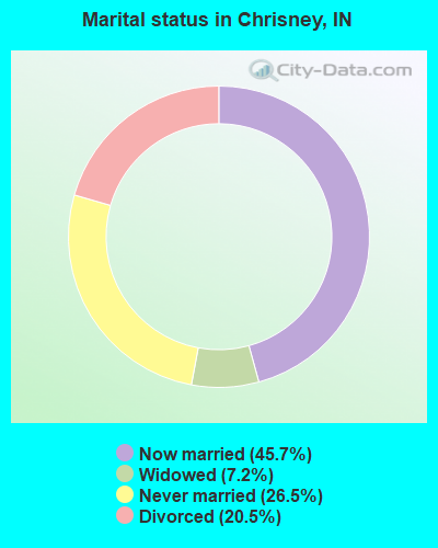
- Never married: 26.5%
- Now married: 45.7%
- Separated: 0.0%
- Widowed: 7.2%
- Divorced: 20.5%
For population 25 years and over in Chrisney:
- High school or higher: 85.9%
- Bachelor's degree or higher: 10.3%
- Graduate or professional degree: 5.2%
- Unemployed: 5.1%
- Mean travel time to work (commute): 47.9 minutes
| Here: | 9.1 |
| Indiana average: | 11.3 |

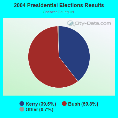
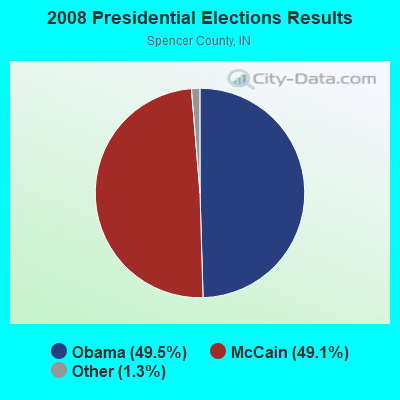
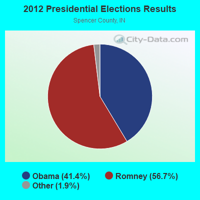
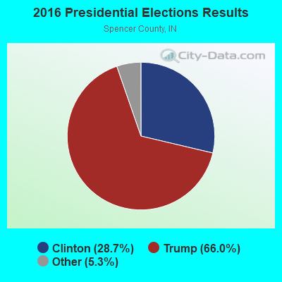
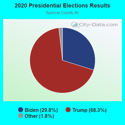
Graphs represent county-level data. Detailed 2008 Election Results
Religion statistics for Chrisney, IN (based on Spencer County data)
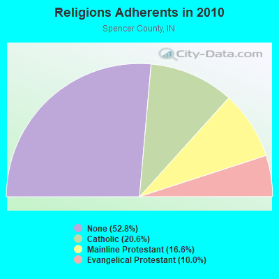
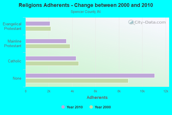
| Religion | Adherents | Congregations |
|---|---|---|
| Catholic | 4,309 | 8 |
| Mainline Protestant | 3,486 | 22 |
| Evangelical Protestant | 2,098 | 21 |
| Other | - | 1 |
| None | 11,059 | - |
Food Environment Statistics:
| Here: | 1.97 / 10,000 pop. |
| State: | 1.73 / 10,000 pop. |
| Spencer County: | 0.49 / 10,000 pop. |
| State: | 0.50 / 10,000 pop. |
| Spencer County: | 6.41 / 10,000 pop. |
| State: | 3.57 / 10,000 pop. |
| This county: | 4.44 / 10,000 pop. |
| Indiana: | 6.78 / 10,000 pop. |
| This county: | 9.5% |
| Indiana: | 9.2% |
| This county: | 29.0% |
| State: | 29.0% |
| Spencer County: | 16.5% |
| Indiana: | 14.3% |
Health and Nutrition:
| This city: | 46.7% |
| State: | 49.3% |
| Here: | 40.7% |
| Indiana: | 46.2% |
| Chrisney: | 28.6 |
| State: | 28.7 |
| Chrisney: | 20.4% |
| State: | 21.3% |
| This city: | 10.5% |
| State: | 10.6% |
| Here: | 6.8 |
| State: | 6.8 |
| This city: | 34.5% |
| Indiana: | 33.9% |
| Chrisney: | 52.4% |
| Indiana: | 56.1% |
| Here: | 76.3% |
| Indiana: | 78.7% |
More about Health and Nutrition of Chrisney, IN Residents
| Local government employment and payroll (March 2022) | |||||
| Function | Full-time employees | Monthly full-time payroll | Average yearly full-time wage | Part-time employees | Monthly part-time payroll |
|---|---|---|---|---|---|
| Financial Administration | 2 | $7,601 | $45,606 | 9 | $12,074 |
| Police - Other | 0 | $0 | 1 | $1,110 | |
| Totals for Government | 2 | $7,601 | $45,606 | 10 | $13,184 |
Chrisney government finances - Expenditure in 2017 (per resident):
- Current Operations - Water Utilities: $305,000 ($651.71)
Gas Utilities: $145,000 ($309.83)
Sewerage: $137,000 ($292.74)
Central Staff Services: $68,000 ($145.30)
Local Fire Protection: $19,000 ($40.60)
Parks and Recreation: $12,000 ($25.64)
Regular Highways: $1,000 ($2.14)
Miscellaneous Commercial Activities - Other: $1,000 ($2.14)
- General - Interest on Debt: $42,000 ($89.74)
Chrisney government finances - Revenue in 2017 (per resident):
- Charges - Sewerage: $174,000 ($371.79)
Parks and Recreation: $6,000 ($12.82)
- Local Intergovernmental - Other: $44,000 ($94.02)
Highways: $2,000 ($4.27)
- Miscellaneous - Donations From Private Sources: $9,000 ($19.23)
- Revenue - Water Utilities: $373,000 ($797.01)
Gas Utilities: $165,000 ($352.56)
- State Intergovernmental - Other: $121,000 ($258.55)
Highways: $17,000 ($36.32)
General Local Government Support: $2,000 ($4.27)
- Tax - Property: $56,000 ($119.66)
Other License: $1,000 ($2.14)
Chrisney government finances - Debt in 2017 (per resident):
- Long Term Debt - Beginning Outstanding - Unspecified Public Purpose: $478,000 ($1021.37)
Outstanding Unspecified Public Purpose: $478,000 ($1021.37)
Chrisney government finances - Cash and Securities in 2017 (per resident):
- Bond Funds - Cash and Securities: $4,000 ($8.55)
- Other Funds - Cash and Securities: $699,000 ($1493.59)
- Sinking Funds - Cash and Securities: $57,000 ($121.79)
Strongest AM radio stations in Chrisney:
- WVJS (1420 AM; 5 kW; OWENSBORO, KY; Owner: TSB III, LLC)
- WKCM (1160 AM; 2 kW; HAWESVILLE, KY; Owner: HANCOCK COMMUNICATIONS, INC.)
- WHAS (840 AM; 50 kW; LOUISVILLE, KY; Owner: CLEAR CHANNEL BROADCASTING LICENSES, INC.)
- WGBF (1280 AM; 5 kW; EVANSVILLE, IN; Owner: CLEAR CHANNEL BROADCASTING LICENSES, INC.)
- WVHI (1330 AM; 5 kW; EVANSVILLE, IN)
- WSM (650 AM; 50 kW; NASHVILLE, TN; Owner: GAYLORD ENTERTAINMENT COMPANY)
- WTCJ (1230 AM; 1 kW; TELL CITY, IN; Owner: HANCOCK COMMUNICATIONS, INC.)
- WKDA (1200 AM; 50 kW; NASHVILLE, TN; Owner: RADIO NASHVILLE, INC.)
- WAMB (1160 AM; 50 kW; DONELSON, TN; Owner: GREAT SOUTHERN BROADCASTING COMPANY, INC.)
- WNQM (1300 AM; 50 kW; NASHVILLE, TN; Owner: WNQM. INC.)
- WIBC (1070 AM; 50 kW; INDIANAPOLIS, IN; Owner: EMMIS RADIO LICENSE CORPORATION)
- WLAC (1510 AM; 50 kW; NASHVILLE, TN; Owner: CAPSTAR TX LIMITED PARTNERSHIP)
- WLW (700 AM; 50 kW; CINCINNATI, OH; Owner: JACOR BROADCASTING CORPORATION)
Strongest FM radio stations in Chrisney:
- WYXY (107.1 FM; BOONVILLE, IN; Owner: BOONVILLE BROADCASTING CO., INC.)
- WNIN-FM (88.3 FM; EVANSVILLE, IN; Owner: TRI-STATE PUBLIC TELEPLEX, INC.)
- WGZB-FM (96.5 FM; CORYDON, IN; Owner: BLUE CHIP BROADCASTING LICENSES II, LTD.)
- WAXL (103.3 FM; SANTA CLAUS, IN; Owner: DUBOIS COUNTY BROADCASTING, INC.)
- WSTO (96.1 FM; OWENSBORO, KY; Owner: TSB III, LLC)
- WBDC (100.9 FM; HUNTINGBURG, IN; Owner: DUBOIS COUNTY BROADCASTING, INC.)
- WBKR (92.5 FM; OWENSBORO, KY; Owner: REGENT BROADCASTING OF EVANSVILLE/OWENSBORO, INC.)
- WQKZ (98.5 FM; FERDINAND, IN; Owner: GEM COMMUNICATIONS LLP)
- WKDQ (99.5 FM; HENDERSON, KY; Owner: REGENT BROADCASTING OF EVANSVILLE/OWENSBORO, INC.)
- WTCJ-FM (105.7 FM; TELL CITY, IN; Owner: HANCOCK COMMUNICATIONS, INC.)
- WJPS-FM (93.5 FM; CHANDLER, IN; Owner: SOUTH CENTRAL COMMUNICATIONS CORP.)
- WXCM (97.1 FM; HAWESVILLE, KY; Owner: WLME, INC.)
- WKPB (89.5 FM; HENDERSON, KY; Owner: WESTERN KENTUCKY UNIVERSITY)
- WBGW (101.5 FM; FORT BRANCH, IN; Owner: MUSIC MINISTRIES, INC.)
- WIKY-FM (104.1 FM; EVANSVILLE, IN; Owner: SOUTH CENTRAL B/C CORPORATION)
- WABX (107.5 FM; EVANSVILLE, IN; Owner: SOUTH CENTRAL COMMUNICATIONS CORP.)
- WITZ-FM (104.7 FM; JASPER, IN; Owner: JASPER ON THE AIR, INC.)
- WLME (102.9 FM; CANNELTON, IN; Owner: HANCOCK COMMUNICATIONS, INC)
- WBIO (94.7 FM; PHILPOT, KY; Owner: THE CROMWELL GROUP, INC OF KENTUCKY)
- W246AF (97.1 FM; OWENSBORO, KY; Owner: FM 90.1, INC.)
TV broadcast stations around Chrisney:
- WNIN (Channel 9; EVANSVILLE, IN; Owner: TRI-STATE PUBLIC TELEPLEX, INC.)
- WTVW (Channel 7; EVANSVILLE, IN; Owner: QUORUM OF INDIANA LICENSE, LLC)
- K55HL (Channel 55; CAPE GIRARDEAU, MO; Owner: MS COMMUNICATIONS, LLC)
- WFIE (Channel 14; EVANSVILLE, IN; Owner: LIBCO, INC.)
- WEVV (Channel 44; EVANSVILLE, IN; Owner: COMCORP OF INDIANA LICENSE CORP.)
- WEHT (Channel 25; EVANSVILLE, IN; Owner: GILMORE BROADCASTING CORPORATION)
- WKOH (Channel 31; OWENSBORO, KY; Owner: KENTUCKY AUTHORITY FOR EDUCATIONAL TV)
- W38BK (Channel 38; EVANSVILLE, IN; Owner: TRINITY BROADCASTING NETWORK)
- WJTS-LP (Channel 27; JASPER, IN; Owner: PAUL E. KNIES)
- W56DN (Channel 56; EVANSVILLE, IN; Owner: EVANSVILLE LOW POWER PARTNERSHIP)
- WTSN-LP (Channel 63; EVANSVILLE, IN; Owner: EVANSVILLE LOW POWER PARTNERSHIP)
- WAZE-LP (Channel 17; EVANSVILLE, IN; Owner: SOUTH CENTRAL COMMUNICATIONS CORP.)
- WEOA-LP (Channel 50; EVANSVILLE, IN; Owner: SOUTH CENTRAL COMMUNICATIONS CORP.)
- W12BJ (Channel 12; OWENSBORO, KY; Owner: UNIVERSITY OF KENTUCKY)
Chrisney fatal accident list:
May 4, 2015 10:16 PM, Us- 231, Sr-70, Lat: 38.002197, Lon: -87.024011, Vehicles: 2, Persons: 3, Fatalities: 2
Jun 5, 2012 09:44 AM, Cr-475 W, Lat: 38.055008, Lon: -87.145314, Vehicles: 1, Persons: 1, Fatalities: 1
Jan 21, 2010 06:29 AM, Us-231, Lat: 38.038864, Lon: -87.036439, Vehicles: 2, Persons: 2, Fatalities: 1
Jan 30, 2007 06:55 PM, Cr-250, Cr-1000, Lat: 38.032081, Lon: -87.008297, Vehicles: 1, Persons: 4, Fatalities: 1
Oct 10, 1978 06:40 PM, Vehicles: 2, Persons: 2, Fatalities: 1
- National Bridge Inventory (NBI) Statistics
- 30Number of bridges
- 194ft / 58.5mTotal length
- 57,623Total average daily traffic
- 5,826Total average daily truck traffic
- 82,891Total future (year 2030) average daily traffic
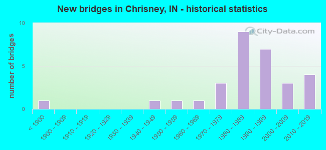
- New bridges - historical statistics
- 1Before 1900
- 11940-1949
- 11950-1959
- 11960-1969
- 31970-1979
- 91980-1989
- 71990-1999
- 32000-2009
- 42010-2019
FCC Registered Cell Phone Towers:
1 (See the full list of FCC Registered Cell Phone Towers in Chrisney)FCC Registered Antenna Towers:
26 (See the full list of FCC Registered Antenna Towers)FCC Registered Broadcast Land Mobile Towers:
5- 920 E 800 N (Lat: 38.004472 Lon: -87.039889), Type: Tower, Structure height: 91.4 m, Overall height: 97.5 m, Call Sign: KNIT654,
Assigned Frequencies: 156.195 MHz, 156.195 MHz, 155.677 MHz, 154.755 MHz, Grant Date: 02/27/2024, Expiration Date: 05/23/2034, Registrant: Cara Enterprises, Inc., 918 E 800 N, Las Vegas, NV 89140-0124, Phone: (702) 838-9728, Fax: (702) 363-4607, Email:
- 1 Mi N Of Ind 70 2 Mi E Ind 231 (Lat: 38.011444 Lon: -87.000556), Call Sign: KNGJ506,
Assigned Frequencies: 151.655 MHz, Grant Date: 07/14/2023, Expiration Date: 05/24/2033, Registrant: Atlas License Company, 207 North State St Box 495, Greenfield, IN 46140, Phone: (317) 813-4865, Email:
- Pump Station (Lat: 38.017556 Lon: -87.008611), Type: Tank, Structure height: 15 m, Call Sign: WPJY744,
Assigned Frequencies: 456.425 MHz, Grant Date: 12/16/1996, Expiration Date: 12/16/2001, Cancellation Date: 05/05/2002, Certifier: Kent L Groves, Registrant: National License Corp, 9050 Briarclift Rd, Indianapolis, IN 46256, Fax: (317) 841-3328
- 9334 North Us 231 (Lat: 38.023056 Lon: -87.036667), Type: Pole, Structure height: 3 m, Overall height: 3.2 m, Call Sign: WQJH633,
Assigned Frequencies: 451.437 MHz, Grant Date: 09/12/2008, Expiration Date: 09/12/2018, Cancellation Date: 11/17/2018, Certifier: Woward W Geck, Registrant: Skylines Unlimited Inc, 100 Stone Church Road, Carlisle, PA 17015, Phone: (717) 218-5003, Fax: (717) 218-5005, Email:
- GR. ST. TANK, West County Road 750 N. (Lat: 37.995806 Lon: -87.082778), Type: Pole, Structure height: 5 m, Overall height: 6 m, Call Sign: WQVM459, Licensee ID: L01930295,
Assigned Frequencies: 173.337 MHz, Grant Date: 03/27/2015, Expiration Date: 03/27/2025, Certifier: Marty Brown, Registrant: Town Of Gentryville, 240 West Boone Street, Gentryville, IN 47537, Phone: (812) 937-2407
FCC Registered Microwave Towers:
1- MGT, On Hwy 70 , Approx. 0.1 Miles East Of County Road 210e (Lat: 38.004167 Lon: -87.015611), Type: Mtower, Structure height: 30.5 m, Call Sign: WQTQ265,
Assigned Frequencies: 954.350 MHz, 953.950 MHz, Grant Date: 02/29/2024, Expiration Date: 03/21/2034, Certifier: John C Van Vorst, Registrant: Mona Lee & Associates LLC., 3730 Kirby Drive, Suite 1200, Pmb 165, Houston, TX 77098, Phone: (832) 850-7646, Email:
FCC Registered Amateur Radio Licenses:
11 (See the full list of FCC Registered Amateur Radio Licenses in Chrisney)FAA Registered Aircraft:
2- Aircraft: DESTINY 2000 (Category: Land, Seats: 2, Weight: Up to 12,499 Pounds), Engine: ROTAX 582SER (65 HP) (2 Cycle)
N-Number: 2553L, N2553L, N-2553L, Serial Number: 2C0354RWB, Year manufactured: 2001, Airworthiness Date: 11/15/2007, Certificate Issue Date: 10/03/2012
Registrant (Individual): John L Mogan, 13084 N County Road 200 E, Chrisney, IN 47611
Deregistered: Cancel Date: 03/02/2019 - Aircraft: PIPER PA-28-140 (Category: Land, Seats: 4, Weight: Up to 12,499 Pounds, Speed: 107 mph), Engine: LYCOMING 0-320 SERIES (180 HP) (Reciprocating)
N-Number: 551FL, N551FL, N-551FL, Serial Number: 28-7125388, Year manufactured: 1971, Airworthiness Date: 04/19/1971, Certificate Issue Date: 06/29/2011
Registrant (Individual): Howard T Shrode, 2898 E County Road 1000 N, Chrisney, IN 47611
Deregistered: Cancel Date: 10/27/2017
2002 - 2017 National Fire Incident Reporting System (NFIRS) incidents
- Fire incident types reported to NFIRS in Chrisney, IN
- 7345.6%Outside Fires
- 5635.0%Structure Fires
- 2213.8%Mobile Property/Vehicle Fires
- 95.6%Other
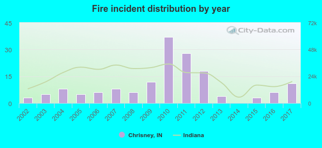 Based on the data from the years 2002 - 2017 the average number of fire incidents per year is 10. The highest number of fire incidents - 37 took place in 2010, and the least - 0 in 2014. The data has a growing trend.
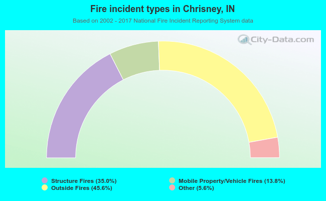 When looking into fire subcategories, the most incidents belonged to: Outside Fires (45.6%), and Structure Fires (35.0%).
| Most common first names in Chrisney, IN among deceased individuals | ||
| Name | Count | Lived (average) |
|---|---|---|
| Mary | 19 | 80.1 years |
| John | 18 | 77.2 years |
| Walter | 11 | 80.5 years |
| William | 11 | 74.8 years |
| Charles | 7 | 80.7 years |
| Carl | 7 | 78.4 years |
| Robert | 7 | 72.0 years |
| James | 7 | 74.3 years |
| Helen | 6 | 74.5 years |
| Harold | 6 | 75.5 years |
| Most common last names in Chrisney, IN among deceased individuals | ||
| Last name | Count | Lived (average) |
|---|---|---|
| Weber | 9 | 66.3 years |
| Ayer | 8 | 74.0 years |
| Raven | 8 | 81.6 years |
| Price | 8 | 77.8 years |
| Johnson | 7 | 80.7 years |
| Jones | 7 | 66.6 years |
| Purviance | 6 | 84.8 years |
| Atkinson | 6 | 82.0 years |
| Snyder | 6 | 79.8 years |
| Curl | 5 | 77.8 years |
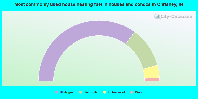
- 70.0%Utility gas
- 21.7%Electricity
- 6.7%No fuel used
- 1.7%Wood
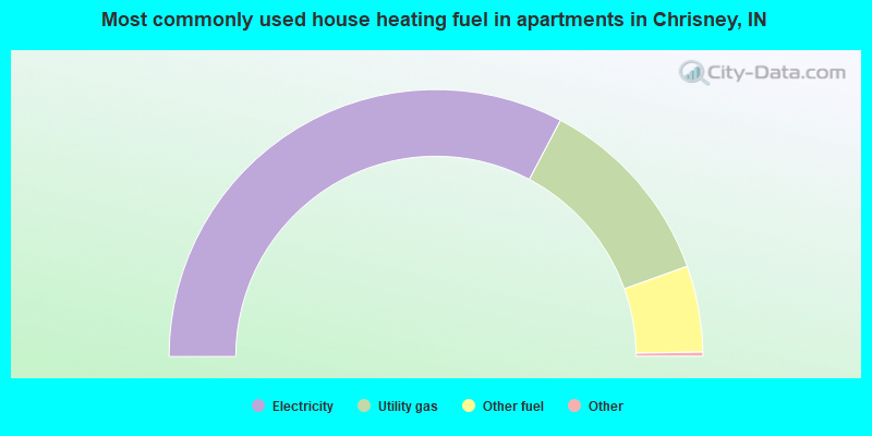
- 65.8%Electricity
- 23.7%Utility gas
- 10.5%Other fuel
Chrisney compared to Indiana state average:
- Median house value below state average.
- Unemployed percentage below state average.
- Black race population percentage significantly below state average.
- Hispanic race population percentage significantly below state average.
- Foreign-born population percentage significantly below state average.
- Length of stay since moving in significantly above state average.
- House age above state average.
- Number of college students significantly below state average.
- Percentage of population with a bachelor's degree or higher below state average.