Cooter, Missouri

Submit your own pictures of this city and show them to the world

Percentage of residents living in poverty in 2022: 17.8%
(15.8% for White Non-Hispanic residents, 50.0% for two or more races residents)

Full-time law enforcement employees in 2015, including police officers: 1 (1 officers - 1 male; 0 female).
Officers per 1,000 residents here:

2.27
Missouri average:

2.46
Recent articles from our blog. Our writers, many of them Ph.D. graduates or candidates, create easy-to-read articles on a wide variety of topics.
Unemployment in December 2023:
Here:

5.0%
Missouri:

2.8%
Most common industries in Cooter, MO (%)
Both Males Females
Most common industries in 2000
  • Educational services (12.8%)
  • Truck transportation (9.3%)
  • Construction (8.1%)
  • Metal & metal products (7.6%)
  • Health care (6.4%)
  • Public administration (5.8%)
  • Agriculture, forestry, fishing & hunting (5.2%)
Most common industries for males in 2000
  • Construction (13.7%)
  • Truck transportation (13.7%)
  • Metal & metal products (12.7%)
  • Agriculture, forestry, fishing & hunting (6.9%)
  • Building material & garden equipment & supplies dealers (5.9%)
  • Public administration (4.9%)
  • Department & other general merchandise stores (3.9%)
Most common industries for females in 2000
  • Educational services (25.7%)
  • Health care (15.7%)
  • Social assistance (8.6%)
  • Public administration (7.1%)
  • Finance & insurance (7.1%)
  • Administrative & support & waste management services (5.7%)
  • Department & other general merchandise stores (4.3%)
Most common occupations in Cooter, MO (%)
Both Males Females
Most common occupations in 2000
  • Vehicle and mobile equipment mechanics, installers, and repairers (7.0%)
  • Other sales and related occupations, including supervisors (6.4%)
  • Building and grounds cleaning and maintenance occupations (5.8%)
  • Driver/sales workers and truck drivers (5.8%)
  • Construction laborers (4.7%)
  • Other production occupations, including supervisors (4.7%)
  • Other teachers, instructors, education, training, and library occupations (4.1%)
Most common occupations for males in 2000
  • Vehicle and mobile equipment mechanics, installers, and repairers (11.8%)
  • Driver/sales workers and truck drivers (9.8%)
  • Construction laborers (7.8%)
  • Other production occupations, including supervisors (7.8%)
  • Other sales and related occupations, including supervisors (5.9%)
  • Agricultural workers, including supervisors (4.9%)
  • Carpenters (4.9%)
Most common occupations for females in 2000
  • Building and grounds cleaning and maintenance occupations (11.4%)
  • Child care workers (8.6%)
  • Other teachers, instructors, education, training, and library occupations (7.1%)
  • Other sales and related occupations, including supervisors (7.1%)
  • Cooks and food preparation workers (5.7%)
  • Information and record clerks, except customer service representatives (5.7%)
  • Registered nurses (5.7%)

Average climate in Cooter, Missouri

Based on data reported by over 4,000 weather stations

Cooter, Missouri average temperatures Cooter, Missouri average precipitation Cooter, Missouri humidity Cooter, Missouri wind speed Cooter, Missouri snowfall Cooter, Missouri sunshine Cooter, Missouri clear and cloudy days
Air pollution and air quality trends
(lower is better)
AQI PM2.5
Air Quality Index

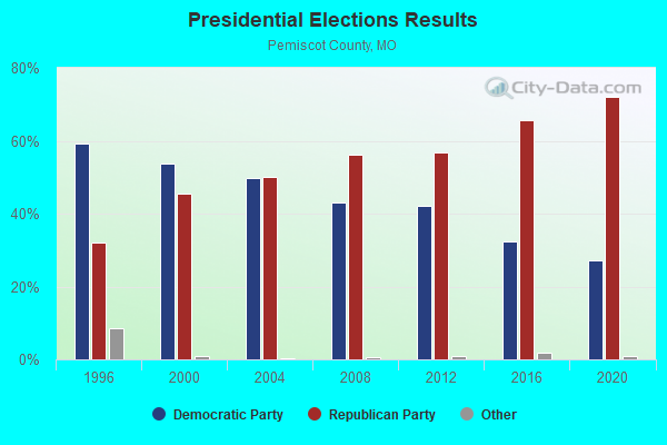
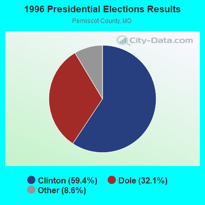
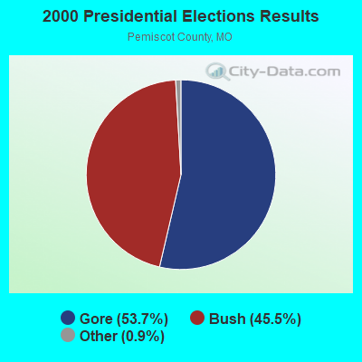
Air Quality Index (AQI) level in 2022 was 61.7. This is about average.

City:

61.7
U.S.:

72.6
Particulate Matter Level

Particulate Matter (PM2.5) [µg/m3] level in 2022 was 7.65. This is about average. Closest monitor was 9.5 miles away from the city center.

City:

7.65
U.S.:

8.11

Tornado activity:

Cooter-area historical tornado activity is slightly above Missouri state average. It is 112% greater than the overall U.S. average.

On 3/21/1952, a category F4 (max. wind speeds 207-260 mph) tornado 0.6 miles away from the Cooter city center killed 17 people and injured 100 people and caused between $500,000 and $5,000,000 in damages.

On 3/1/1997, a category F4 tornado 8.3 miles away from the city center caused $30,000 in damages.

Earthquake activity:

Cooter-area historical earthquake activity is significantly above Missouri state average. It is 415% greater than the overall U.S. average.

On 5/4/1991 at 01:18:54, a magnitude 5.0 (4.4 MB, 4.6 LG, 5.0 LG, Depth: 3.1 mi, Class: Moderate, Intensity: VI - VII) earthquake occurred 35.8 miles away from the city center
On 3/25/1976 at 00:41:20, a magnitude 5.0 (4.9 MB, 5.0 LG) earthquake occurred 40.5 miles away from Cooter center
On 4/27/1989 at 16:47:49, a magnitude 4.7 (4.6 MB, 4.7 LG, 4.3 LG, Class: Light, Intensity: IV - V) earthquake occurred 3.6 miles away from the city center
On 9/26/1990 at 13:18:51, a magnitude 5.0 (4.7 MB, 4.8 LG, 5.0 LG, Depth: 7.7 mi) earthquake occurred 79.0 miles away from the city center
On 4/18/2008 at 09:36:59, a magnitude 5.4 (5.1 MB, 4.8 MS, 5.4 MW, 5.2 MW) earthquake occurred 197.3 miles away from Cooter center
On 9/29/1987 at 00:04:56, a magnitude 4.6 (4.6 MB, 4.5 LG) earthquake occurred 68.5 miles away from Cooter center
Magnitude types: regional Lg-wave magnitude (LG), body-wave magnitude (MB), surface-wave magnitude (MS), moment magnitude (MW)

Natural disasters:

The number of natural disasters in Pemiscot County (22) is greater than the US average (15).
Major Disasters (Presidential) Declared: 13
Emergencies Declared: 5

Causes of natural disasters: Floods: 15, Storms: 14, Tornadoes: 13, Winds: 6, Winter Storms: 4, Heavy Rain: 1, Hurricane: 1, Other: 1 (Note: some incidents may be assigned to more than one category).
Cooter topographic map

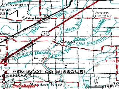
Hospitals and medical centers near Cooter:

  • RIVER OAKS CARE CENTER (Nursing Home, about 3 miles away; STEELE, MO)
  • FMCNA - BLYTHEVILLE (Dialysis Facility, about 9 miles away; BLYTHEVILLE, AR)
  • GREAT RIVER MEDICAL CENTER Acute Care Hospitals (about 10 miles away; BLYTHEVILLE, AR)
  • BLYTHEVILLE NURSING CENTER (Nursing Home, about 10 miles away; BLYTHEVILLE, AR)
  • HOME HEALTH PROFESSIONALS INC (Home Health Center, about 10 miles away; BLYTHEVILLE, AR)
  • KEITH ACRES (Nursing Home, about 11 miles away; BLYTHEVILLE, AR)
  • GOSNELL THERAPY AND LIVING CENTER (Nursing Home, about 11 miles away; GOSNELL, AR)

Colleges/universities with over 2000 students nearest to Cooter:

  • Dyersburg State Community College (about 24 miles; Dyersburg, TN; Full-time enrollment: 2,211)
  • Arkansas State University-Main Campus (about 51 miles; Jonesboro, AR; FT enrollment: 12,323)
  • The University of Tennessee-Martin (about 57 miles; Martin, TN; FT enrollment: 7,013)
  • Union University (about 60 miles; Jackson, TN; FT enrollment: 4,051)
  • Three Rivers Community College (about 62 miles; Poplar Bluff, MO; FT enrollment: 3,360)
  • Rhodes College (about 63 miles; Memphis, TN; FT enrollment: 2,052)
  • Jackson State Community College (about 64 miles; Jackson, TN; FT enrollment: 2,958)

Public high school in Cooter:

  • COOTER HIGH (Students: 170, Location: MAIN ST, Grades: 7-12)

Public elementary/middle school in Cooter:

  • COOTER ELEM. (Students: 141, Location: MAIN ST, Grades: KG-6)
See full list of schools located in Cooter

Points of interest:

Click to draw/clear city borders

Notable location: Cooter Volunteer Fire Department (A). Display/hide its location on the map

Pemiscot County has a predicted average indoor radon screening level less than 2 pCi/L (pico curies per liter) - Low Potential

Drinking water stations with addresses in Cooter and their reported violations in the past:

COOTER (Population served: 440, Purch groundwater):
Past monitoring violations:
  • Follow-up Or Routine LCR Tap M/R - In OCT-01-2007, Contaminant: Lead and Copper Rule
  • 2 routine major monitoring violations
  • One minor monitoring violation
Average household size:
This city:

2.7 people
Missouri:

2.5 people

Percentage of family households:
This city:

76.0%
Whole state:

65.3%

Percentage of households with unmarried partners:
This city:

5.7%
Whole state:

6.7%


Likely homosexual households (counted as self-reported same-sex unmarried-partner households)
  • Lesbian couples: 0.0% of all households
  • Gay men: 1.1% of all households
Educational Attainment in 2022
School Enrollment by Level of School in 2022
Education Gini index (Inequality in education)
Here:

12.0
Missouri average:

11.1

Presidential Elections Results

Graphs represent county-level data. Detailed 2008 Election Results

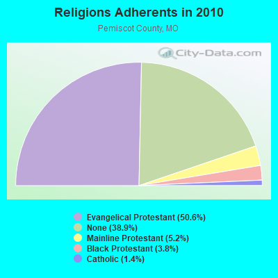
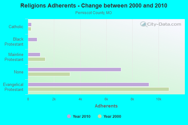
Religion statistics for Cooter, MO (based on Pemiscot County data)

Religions Adherents in 2010
Religions Adherents - Change between 2000 and 2010
ReligionAdherentsCongregations
Evangelical Protestant9,26545
Mainline Protestant9457
Black Protestant6985
Catholic2631
Other1-
None7,124-
Source: Clifford Grammich, Kirk Hadaway, Richard Houseal, Dale E.Jones, Alexei Krindatch, Richie Stanley and Richard H.Taylor. 2012. 2010 U.S.Religion Census: Religious Congregations & Membership Study. Association of Statisticians of American Religious Bodies. Jones, Dale E., et al. 2002. Congregations and Membership in the United States 2000. Nashville, TN: Glenmary Research Center. Graphs represent county-level data

Food Environment Statistics:

Number of grocery stores: 8
Pemiscot County:

4.27 / 10,000 pop.
State:

1.88 / 10,000 pop.
Number of convenience stores (no gas): 2
Pemiscot County:

1.07 / 10,000 pop.
Missouri:

0.60 / 10,000 pop.
Number of convenience stores (with gas): 8
Pemiscot County:

4.27 / 10,000 pop.
Missouri:

4.34 / 10,000 pop.
Number of full-service restaurants: 15
Pemiscot County:

8.00 / 10,000 pop.
State:

7.37 / 10,000 pop.
Adult diabetes rate:
Pemiscot County:

9.9%
Missouri:

8.8%
Adult obesity rate:
Pemiscot County:

31.6%
Missouri:

29.6%
Low-income preschool obesity rate:
This county:

19.1%
State:

13.5%

Health and Nutrition:

Healthy diet rate:
Cooter:

44.2%
State:

50.9%

Average overall health of teeth and gums:
Here:

35.9%
State:

48.6%

Average BMI:
This city:

28.4
Missouri:

28.7

People feeling badly about themselves:
Cooter:

24.3%
Missouri:

20.6%

People not drinking alcohol at all:
Here:

11.0%
Missouri:

10.1%

Average hours sleeping at night:
Here:

6.8
Missouri:

6.8

Overweight people:
Here:

31.7%
Missouri:

34.3%

General health condition:
Here:

48.4%
State:

57.5%

Average condition of hearing:
Cooter:

74.1%
Missouri:

79.3%

More about Health and Nutrition of Cooter, MO Residents
Local government employment and payroll (March 2022)
Function Full-time employees Monthly full-time payroll Average yearly full-time wage Part-time employees Monthly part-time payroll
Other Government Administration 1$1,727$20,7240$0
Totals for Government 1$1,727$20,7240$0

Cooter government finances - Expenditure in 2017 (per resident):

  • Construction - Parks and Recreation: $80,000 ($244.65)
    Toll Highways: $7,000 ($21.41)
  • Current Operations - Police Protection: $163,000 ($498.47)
    Water Utilities: $114,000 ($348.62)
    Sewerage: $96,000 ($293.58)
    General Public Buildings: $86,000 ($263.00)
    Parks and Recreation: $62,000 ($189.60)
    General - Other: $36,000 ($110.09)
    Toll Highways: $24,000 ($73.39)
  • Total Salaries and Wages: $284,000 ($868.50)
  • Water Utilities - Interest on Debt: $27,000 ($82.57)

Cooter government finances - Revenue in 2017 (per resident):

  • Charges - Sewerage: $95,000 ($290.52)
    Solid Waste Management: $20,000 ($61.16)
  • Miscellaneous - Fines and Forfeits: $88,000 ($269.11)
    General Revenue - Other: $29,000 ($88.69)
    Interest Earnings: $5,000 ($15.29)
    Rents: $4,000 ($12.23)
  • Revenue - Water Utilities: $107,000 ($327.22)
  • State Intergovernmental - Highways: $17,000 ($51.99)
  • Tax - General Sales and Gross Receipts: $448,000 ($1370.03)
    Public Utilities Sales: $22,000 ($67.28)
    Property: $19,000 ($58.10)
    Occupation and Business License - Other: $2,000 ($6.12)
    Alcoholic Beverage License: $1,000 ($3.06)

Cooter government finances - Debt in 2017 (per resident):

  • Long Term Debt - Outstanding Unspecified Public Purpose: $663,000 ($2027.52)
    Beginning Outstanding - Unspecified Public Purpose: $663,000 ($2027.52)

Cooter government finances - Cash and Securities in 2017 (per resident):

  • Other Funds - Cash and Securities: $994,000 ($3039.76)

Strongest AM radio stations in Cooter:

  • KLCN (910 AM; 5 kW; BLYTHEVILLE, AR; Owner: SUDBURY SERVICES, INC.)
  • KOTC (830 AM; daytime; 10 kW; KENNETT, MO; Owner: EAGLE BLUFF ENTERPRISES)
  • WDIA (1070 AM; 50 kW; MEMPHIS, TN; Owner: CLEAR CHANNEL BROADCASTING LICENSES, INC.)
  • WCRV (640 AM; 50 kW; COLLIERVILLE, TN; Owner: BOTT BROADCASTING COMPANY/TENNESSEE)
  • WGSF (1030 AM; 50 kW; MEMPHIS, TN; Owner: FLINN BROADCASTING CORPORATION)
  • WMQM (1600 AM; 50 kW; LAKELAND, TN; Owner: WMQM, INC.)
  • KCRV (1370 AM; 1 kW; CARUTHERSVILLE, MO; Owner: POLLACK BROADCASTING CO.)
  • WJCE (680 AM; 10 kW; MEMPHIS, TN; Owner: ENTERCOM MEMPHIS LICENSE, LLC)
  • KWAM (990 AM; 10 kW; MEMPHIS, TN; Owner: CONCORD MEDIA GROUP, INC.)
  • WHBQ (560 AM; 5 kW; MEMPHIS, TN; Owner: FLINN BROADCASTING CORPORATION)
  • WSM (650 AM; 50 kW; NASHVILLE, TN; Owner: GAYLORD ENTERTAINMENT COMPANY)
  • WCPC (940 AM; 50 kW; HOUSTON, MS; Owner: WCPC BROADCASTING CO., INC.)
  • WREC (600 AM; 5 kW; MEMPHIS, TN; Owner: CLEAR CHANNEL BROADCASTING LICENSES, INC.)

Strongest FM radio stations in Cooter:

  • WJZN (98.9 FM; MUNFORD, TN; Owner: MEMPHIS III LIMITED PARTNERSHIP)
  • KAMJ (93.9 FM; GOSNELL, AR; Owner: PHOENIX BROADCASTING GROUP, INC.)
  • KHLS (96.3 FM; BLYTHEVILLE, AR; Owner: SUDBURY SERVICES, INC.)
  • WKNQ (90.7 FM; DYERSBURG, TN; Owner: MID-SOUTH PUBLIC COMMS. FOUNDATION)
  • KCRV-FM (105.1 FM; CARUTHERSVILLE, MO; Owner: POLLACK BROADCASTING CO.)
  • WASL (100.1 FM; DYERSBURG, TN; Owner: DR PEPPER PEPSI-COLA BOTTLING CO.)
  • W205BN (88.9 FM; DYERSBURG, TN; Owner: WAY-FM MEDIA GROUP, INC.)
  • KBCM (88.3 FM; BLYTHEVILLE, AR; Owner: AMERICAN FAMILY ASSOCIATION)
  • WYPL (89.3 FM; MEMPHIS, TN; Owner: MEMPHIS/SHELBY COUNTY PUBLIC LIBRARY & INFO CNTR.)
  • KQDD (107.3 FM; OSCEOLA, AR; Owner: PHOENIX BROADCASTING GROUP, INC.)
  • KTMO (106.5 FM; NEW MADRID, MO; Owner: POLLACK BROADCASTING CO.)
  • WAPO (90.5 FM; MOUNT VERNON, IL; Owner: AMERICAN FAMILY ASSOCIATION)
  • WAUV (89.7 FM; RIPLEY, TN; Owner: AMERICAN FAMILY ASSOCIATION)
  • WKVZ (94.9 FM; RIPLEY, TN; Owner: EDUCATIONAL MEDIA FOUNDATION)
  • KAUF (89.9 FM; KENNETT, MO; Owner: AMERICAN FAMILY ASSOCIATION)
  • W202BG (88.3 FM; DYERSBURG, TN; Owner: BIBLE BROADCASTING NETWORK, INC.)

TV broadcast stations around Cooter:

  • WDYR-CA (Channel 33; DYERSBURG, TN; Owner: TRI-STATE CHRISTIAN TV, INC.)
  • WJKT (Channel 16; JACKSON, TN; Owner: CLEAR CHANNEL BROADCASTING LICENSES, INC.)

Cooter fatal accident list:

Sep 21, 1983 11:30 PM, E, Vehicles: 1, Persons: 2, Fatalities: 1
  • National Bridge Inventory (NBI) Statistics
  • 9Number of bridges
  • 197ft / 59.6mTotal length
  • 22,659Total average daily traffic
  • 8,711Total average daily truck traffic
  • 40,294Total future (year 2041) average daily traffic

FCC Registered Antenna Towers:

6
  • Jacqueline Brown, 1591 State Highway E (Lat: 36.048750 Lon: -89.813972), Type: 60.7, Structure height: 29155 m, Overall height: 59.4 m, Registrant: Pi Tower Development LLC, C/O Lendlease Americas Inc., Jacqueline.Brown@lendlease.Com, , Charl-otte, Phone: (847) 826-0958

  • Jacqueline Brown, 1591 State Highway E (Lat: 36.048750 Lon: -89.813972), Type: 60.7, Structure height: 29155 m, Overall height: 59.4 m, Registrant: Pi Tower Development LLC, C/O Lendlease Americas Inc., Jacqueline.Brown@lendlease.Com, , Charl-otte, Phone: (847) 826-0958

  • Jacqueline Brown, 1591 State Highway E (Lat: 36.048750 Lon: -89.813972), Type: 60.7, Structure height: 29155 m, Overall height: 59.4 m, Registrant: Pi Tower Development LLC, C/O Lendlease Americas Inc., Jacqueline.Brown@lendlease.Com, , Charl-otte, Phone: (847) 826-0958

  • Jacqueline Brown, 1591 State Highway E (Lat: 36.048750 Lon: -89.813972), Type: 60.7, Structure height: 29155 m, Overall height: 59.4 m, Registrant: Pi Tower Development LLC, C/O Lendlease Americas Inc., Jacqueline.Brown@lendlease.Com, , Charl-otte, Phone: (847) 826-0958

  • Jacqueline Brown, 1591 State Highway E (Lat: 36.048750 Lon: -89.813972), Type: 60.7, Structure height: 29155 m, Overall height: 59.4 m, Registrant: Pi Tower Development LLC, Jacqueline.Brown@harmonitowers.Com, Suite D-3, Charl-otte, Phone: (904) 449-3565

  • Jacqueline Brown, 1591 State Highway E (Lat: 36.048750 Lon: -89.813972), Type: 60.7, Structure height: 29155 m, Overall height: 59.4 m, Registrant: Pi Tower Development LLC, Jacqueline.Brown@harmonitowers.Com, Suite D-3, Charl-otte, Phone: (904) 449-3565


FCC Registered Broadcast Land Mobile Towers:

1
  • MOBILES, Lat: 36.046611 Lon: -89.809611, Call Sign: WQUV299,
    Assigned Frequencies: 159.660 MHz, Grant Date: 10/22/2014, Expiration Date: 10/22/2024, Certifier: Bobby Northcutt, Registrant: Aerowave Technologies, 129 Mustang Creek Dr, Waxahachie, TX 75165, Phone: (214) 222-2376, Fax: (888) 677-8858, Email:


Most common first names in Cooter, MO among deceased individuals
NameCountLived (average)
James1169.6 years
William1070.8 years
John665.0 years
Mary668.7 years
Robert562.8 years
Jessie473.8 years
Lawrence471.5 years
Pearl476.0 years
Thomas471.0 years
Charles359.6 years
Most common last names in Cooter, MO among deceased individuals
Last nameCountLived (average)
Burns781.6 years
Boone569.6 years
Hinklin570.0 years
Anderson572.3 years
Ashcraft481.5 years
Alexander485.0 years
Hollins464.0 years
Jones473.2 years
Thomas472.0 years
Smith483.0 years
Houses and condos Apartments
Most commonly used house heating fuel in houses and condos in Cooter, MO
  • 51.7%Electricity
  • 48.3%Utility gas
Most commonly used house heating fuel in apartments in Cooter, MO
  • 60.0%Electricity
  • 32.0%Utility gas
  • 8.0%Bottled, tank, or LP gas


Cooter compared to Missouri state average:

  • Median house value significantly below state average.
  • Unemployed percentage below state average.
  • Black race population percentage significantly below state average.
  • Hispanic race population percentage significantly below state average.
  • Foreign-born population percentage significantly below state average.
  • Length of stay since moving in significantly above state average.
  • Number of college students significantly below state average.
  • Percentage of population with a bachelor's degree or higher significantly below state average.
There are no pilots and 2 other airmen in this city.
Cost of Living Calculator