Dixie Valley, Nevada
Submit your own pictures of this place and show them to the world
- OSM Map
- General Map
- Google Map
- MSN Map

| Males: 77 | |
| Females: 62 |
| Median resident age: | 50.5 years |
| Nevada median age: | 35.0 years |
Zip code: 89406
| Dixie Valley: | $64,149 |
| NV: | $72,333 |
Estimated per capita income in 2022: $49,384 (it was $26,357 in 2000)
Estimated median house or condo value in 2022: $92,691 (it was $33,200 in 2000)
| Dixie Valley: | $92,691 |
| NV: | $434,700 |


- 12189.6%White alone
- 53.7%American Indian alone
- 43.0%Hispanic
- 32.2%Two or more races
- 21.5%Asian alone

 Recent articles from our blog. Our writers, many of them Ph.D. graduates or candidates, create easy-to-read articles on a wide variety of topics.
Current Local Time: PST time zone
Elevation: 3428 feet
Land area: 2800.3 square miles.
Population density: 0.05 people per square mile (very low).

| Dixie Valley CCD: | 0.0% ($0) |
| Nevada: | 0.9% ($1,187) |
Nearest city with pop. 50,000+: Sparks, NV  (81.1 miles , pop. 66,346).
Nearest city with pop. 200,000+: Sacramento, CA (186.9 miles , pop. 407,018).
Nearest city with pop. 1,000,000+: Los Angeles, CA (375.5 miles , pop. 3,694,820).
Nearest cities:
), ), ), Latitude: 39.51 N, Longitude: 118.22 W


| Here: | 4.1% |
| Nevada: | 5.0% |
Average climate in Dixie Valley, Nevada
Based on data reported by over 4,000 weather stations


Earthquake activity:
Dixie Valley-area historical earthquake activity is significantly above Nevada state average. It is 6201% greater than the overall U.S. average.Natural disasters:
The number of natural disasters in Churchill County (6) is a lot smaller than the US average (15).Major Disasters (Presidential) Declared: 1
Emergencies Declared: 3
Causes of natural disasters: Floods: 2, Snows: 2, Hurricane: 1, Mudslide: 1, Storm: 1, Winter Storm: 1, Other: 1 (Note: some incidents may be assigned to more than one category).
Colleges/universities with over 2000 students nearest to Dixie Valley:
- Truckee Meadows Community College (about 85 miles; Reno, NV; Full-time enrollment: 6,919)
- University of Nevada-Reno (about 86 miles; Reno, NV; FT enrollment: 15,092)
- Western Nevada College (about 88 miles; Carson City, NV; FT enrollment: 2,338)
- Folsom Lake College (about 167 miles; Folsom, CA; FT enrollment: 5,308)
- Sierra College (about 169 miles; Rocklin, CA; FT enrollment: 11,488)
- American River College (about 179 miles; Sacramento, CA; FT enrollment: 20,452)
- Yuba College (about 180 miles; Marysville, CA; FT enrollment: 4,737)
Points of interest:
Notable locations in Dixie Valley: Overland Stage Station (A), Cold Springs Highway Maintenance Station (B), Cripple Creek (C), Anderson Ranch (D), West Gate (E), Alpine Ranch (F), Byers Ranch (G), Bar A-3 Ranch (H), Mountain Well Station (I), Derring Ranch (J), Kent Ranch (K), Freeman Ranch (L), Cold Spring Ranch (M), Rock Springs (N), Canvasback Gun Club (O), Grimes Point Recreation Site (P), Overland Stage Station (Q), Silver Hill (R), La Plata (S), Dromedary Mill (T). Display/hide their locations on the map
Cemetery: Fairview Cemetery (1). Display/hide its location on the map
Lakes, reservoirs, and swamps: Ward Pond (A), Chappelle Pond (B), Spragia Pond (C), Little Freeman Pond (D), Kirkley Pond (E), Kerman Pond (F), Sullivan Pond (G), Sans Pond (H). Display/hide their locations on the map
Streams, rivers, and creeks: Rock Creek (A), Eagle Canyon Creek (B), Big Den Creek (C), Bernice Creek (D), Stillwater Slough (E), North Ford Big Dew Creek (F), Salt Creek (G), Sagehen Creek (H), Road Canyon Creek (I). Display/hide their locations on the map
Parks in Dixie Valley include: Project Shoal Monument (1), Sand Springs Pony Express Station Historical Marker (2), Stillwater National Wildlife Refuge (3). Display/hide their locations on the map
| This place: | 2.4 people |
| Nevada: | 2.6 people |
| This place: | 60.6% |
| Whole state: | 65.3% |
| This place: | 1.4% |
| Whole state: | 8.7% |
No gay or lesbian households reported
| This place: | 4.7% |
| Whole state: | 10.5% |
For population 15 years and over in Dixie Valley:

- Never married: 10.2%
- Now married: 59.4%
- Separated: 4.7%
- Widowed: 0.0%
- Divorced: 30.5%
For population 25 years and over in Dixie Valley:
- High school or higher: 86.1%
- Bachelor's degree or higher: 17.2%
- Graduate or professional degree: 8.2%
- Mean travel time to work (commute): 16.9 minutes


| Here: | 9.9 |
| Nevada average: | 11.9 |
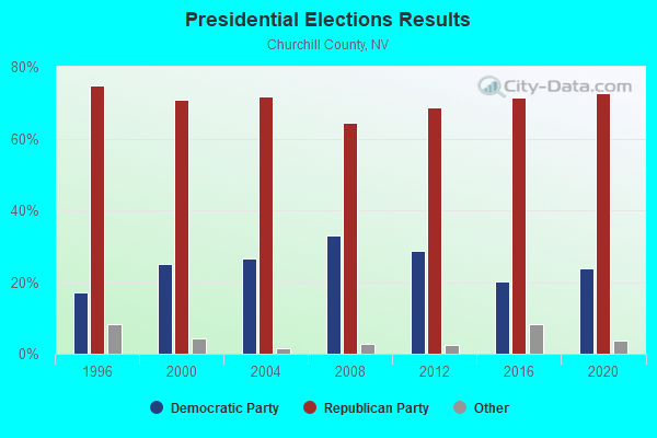
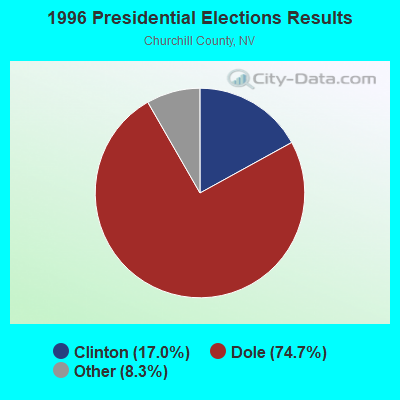
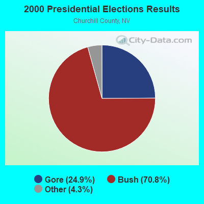
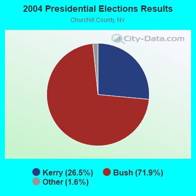
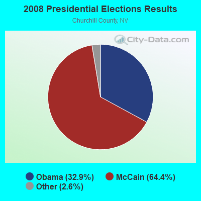

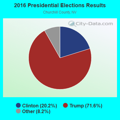

Graphs represent county-level data. Detailed 2008 Election Results
Religion statistics for Dixie Valley, NV (based on Churchill County data)
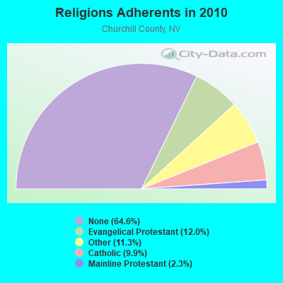
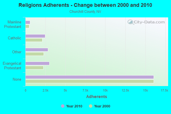
| Religion | Adherents | Congregations |
|---|---|---|
| Evangelical Protestant | 2,985 | 19 |
| Other | 2,803 | 9 |
| Catholic | 2,460 | 1 |
| Mainline Protestant | 568 | 2 |
| None | 16,061 | - |
Food Environment Statistics:
| Churchill County: | 0.81 / 10,000 pop. |
| Nevada: | 1.50 / 10,000 pop. |
| Churchill County: | 2.42 / 10,000 pop. |
| Nevada: | 1.00 / 10,000 pop. |
| Churchill County: | 3.23 / 10,000 pop. |
| State: | 2.56 / 10,000 pop. |
| Here: | 5.65 / 10,000 pop. |
| State: | 6.14 / 10,000 pop. |
| This county: | 8.7% |
| Nevada: | 8.2% |
| Churchill County: | 26.8% |
| Nevada: | 24.5% |
| This county: | 11.4% |
| State: | 13.2% |
10.16% of this county's 2021 resident taxpayers lived in other counties in 2020 ($50,550 average adjusted gross income)
| Here: | 10.16% |
| Nevada average: | 6.67% |
0.26% of residents moved from foreign countries ($1,407 average AGI)
Churchill County: 0.26% Nevada average: 0.05%
Top counties from which taxpayers relocated into this county between 2020 and 2021:
| from Washoe County, NV | |
| from Lyon County, NV | |
| from Clark County, NV |
Strongest AM radio stations in Dixie Valley:
- KKOH (780 AM; 50 kW; RENO, NV; Owner: CITADEL BROADCASTING COMPANY)
- KVLV (980 AM; daytime; 5 kW; FALLON, NV; Owner: LAHONTAN VALLEY BROADCASTING COMPANY, LLC)
- KMJ (580 AM; 50 kW; FRESNO, CA; Owner: INFINITY RADIO OPERATIONS INC.)
- KCBC (770 AM; 50 kW; RIVERBANK, CA; Owner: KIERTRON, INC.)
- KBZZ (1270 AM; 13 kW; SPARKS, NV; Owner: AMERICOM LAS VEGAS LIMITED PARTNERSHIP)
- KHTK (1140 AM; 50 kW; SACRAMENTO, CA; Owner: INFINITY RADIO SUBSIDIARY OPERATIONS INC.)
- KSTE (650 AM; 25 kW; RANCHO CORDOVA, CA; Owner: AMFM RADIO LICENSES, L.L.C.)
- KFIA (710 AM; 25 kW; CARMICHAEL, CA; Owner: VISTA BROADCASTING INC.)
- KWRU (940 AM; 50 kW; FRESNO, CA)
- KNBR (680 AM; 50 kW; SAN FRANCISCO, CA; Owner: KNBR LICO, INC.)
- KCBS (740 AM; 50 kW; SAN FRANCISCO, CA; Owner: INFINITY BROADCASTING OPERATIONS, INC.)
- KFBK (1530 AM; 50 kW; SACRAMENTO, CA; Owner: AMFM RADIO LICENSES, L.L.C.)
- KPTT (630 AM; 5 kW; RENO, NV; Owner: LOTUS RADIO CORP.)
Strongest FM radio stations in Dixie Valley:
- KSVL (92.3 FM; SMITH, NV; Owner: DONEGAL ENTERPRISES)
- KRNG (101.3 FM; FALLON, NV; Owner: SIERRA NV CHRISTIAN MUSIC ASSOC, INC)
- KNHK (92.9 FM; RENO, NV; Owner: CITADEL BROADCASTING COMPANY)
- KRNG-FM1 (101.3 FM; RENO, NV; Owner: SIERRA NV CHRISTIAN MUSIC ASSN INC)

- 47.8%Fuel oil, kerosene, etc.
- 30.4%Bottled, tank, or LP gas
- 21.7%Other fuel

- 48.3%Fuel oil, kerosene, etc.
- 19.0%Wood
- 17.2%Bottled, tank, or LP gas
- 15.5%No fuel used
Dixie Valley compared to Nevada state average:
- Median house value significantly below state average.
- Unemployed percentage significantly below state average.
- Black race population percentage significantly below state average.
- Hispanic race population percentage significantly below state average.
- Median age significantly above state average.
- Foreign-born population percentage significantly below state average.
- Length of stay since moving in significantly above state average.
- Number of rooms per house significantly below state average.
- House age significantly below state average.