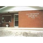
Dorton, Kentucky
Submit your own pictures of this place and show them to the world
- OSM Map
- General Map
- Google Map
- MSN Map

| Males: 1,585 | |
| Females: 1,602 |
| Median resident age: | 38.8 years |
| Kentucky median age: | 35.9 years |
Zip code: 41537
| Dorton: | $40,614 |
| KY: | $59,341 |
Estimated per capita income in 2022: $24,606 (it was $13,513 in 2000)
Dorton CCD income, earnings, and wages data
Estimated median house or condo value in 2022: $102,432 (it was $46,800 in 2000)
| Dorton: | $102,432 |
| KY: | $196,300 |
Detailed information about poverty and poor residents in Dorton, KY


- 3,29798.9%White alone
- 200.6%Hispanic
- 100.3%Two or more races
- 30.09%American Indian alone
- 20.06%Black alone

Races in Dorton detailed stats: ancestries, foreign born residents, place of birth
According to our research of Kentucky and other state lists, there was 1 registered sex offender living in Dorton, Kentucky as of May 09, 2024.
The ratio of all residents to sex offenders in Dorton is 3,187 to 1.
The ratio of registered sex offenders to all residents in this city is much lower than the state average.
 Recent articles from our blog. Our writers, many of them Ph.D. graduates or candidates, create easy-to-read articles on a wide variety of topics.

Current Local Time: EST time zone
Land area: 35.4 square miles.
Population density: 90 people per square mile (very low).

| Dorton CCD: | 0.8% ($358) |
| Kentucky: | 0.8% ($610) |
Nearest city with pop. 50,000+: Johnson City, TN  (66.2 miles , pop. 55,469).
Nearest city with pop. 200,000+: Fayette, KY (117.0 miles , pop. 260,512).
Nearest city with pop. 1,000,000+: Chicago, IL (416.4 miles , pop. 2,896,016).
Nearest cities:
), ), ), ), ), )Latitude: 37.28 N, Longitude: 82.58 W
Area code commonly used in this area: 606


| Here: | 5.3% |
| Kentucky: | 3.8% |

- Mining, quarrying, oil & gas extraction (14.0%)
- Construction (10.1%)
- Health care (10.1%)
- Educational services (7.7%)
- Finance & insurance (6.3%)
- Public administration (5.2%)
- Department & other general merchandise stores (5.0%)

- Mining, quarrying, oil & gas extraction (24.3%)
- Construction (19.3%)
- Educational services (9.3%)
- Truck transportation (8.7%)
- Public administration (5.5%)
- Building material & garden equipment & supplies dealers (3.9%)
- Professional, scientific, technical services (3.9%)

- Health care (19.1%)
- Finance & insurance (11.8%)
- Department & other general merchandise stores (9.9%)
- Educational services (6.0%)
- Public administration (4.9%)
- Personal & laundry services (4.1%)
- Accommodation & food services (3.6%)

- Extraction workers (5.9%)
- Other office and administrative support workers, including supervisors (4.6%)
- Retail sales workers, except cashiers (4.3%)
- Driver/sales workers and truck drivers (3.7%)
- Supervisors, construction and extraction workers (3.6%)
- Other production occupations, including supervisors (3.4%)
- Preschool, kindergarten, elementary, and middle school teachers (3.3%)

- Extraction workers (10.1%)
- Driver/sales workers and truck drivers (7.1%)
- Supervisors, construction and extraction workers (6.9%)
- Construction traders workers except carpenters, electricians, painters, plumbers, and construction laborers (5.5%)
- Metal workers and plastic workers (5.3%)
- Other protective service workers, including supervisors (5.1%)
- Electrical equipment mechanics and other installation, maintenance, and repair workers, including supervisors (4.9%)

- Other office and administrative support workers, including supervisors (9.6%)
- Secretaries and administrative assistants (6.4%)
- Building and grounds cleaning and maintenance occupations (5.8%)
- Material recording, scheduling, dispatching, and distributing workers (5.6%)
- Registered nurses (5.4%)
- Information and record clerks, except customer service representatives (5.1%)
- Health technologists and technicians (5.1%)
Average climate in Dorton, Kentucky
Based on data reported by over 4,000 weather stations


(lower is better)

Air Quality Index (AQI) level in 2022 was 60.7. This is about average.
| City: | 60.7 |
| U.S.: | 72.6 |

Sulfur Dioxide (SO2) [ppb] level in 2002 was 1.08. This is significantly better than average. Closest monitor was 14.2 miles away from the city center.
| City: | 1.08 |
| U.S.: | 1.51 |

Ozone [ppb] level in 2022 was 21.9. This is significantly better than average. Closest monitor was 14.2 miles away from the city center.
| City: | 21.9 |
| U.S.: | 33.3 |

Particulate Matter (PM2.5) [µg/m3] level in 2022 was 6.97. This is about average. Closest monitor was 14.4 miles away from the city center.
| City: | 6.97 |
| U.S.: | 8.11 |
Tornado activity:
Dorton-area historical tornado activity is significantly below Kentucky state average. It is 79% smaller than the overall U.S. average.
On 5/18/1995, a category F2 (max. wind speeds 113-157 mph) tornado 20.9 miles away from the Dorton place center caused between $50,000 and $500,000 in damages.
On 4/4/1974, a category F3 (max. wind speeds 158-206 mph) tornado 46.9 miles away from the place center killed one person and injured 4 people and caused between $50,000 and $500,000 in damages.
Earthquake activity:
Dorton-area historical earthquake activity is significantly above Kentucky state average. It is 25% greater than the overall U.S. average.On 7/27/1980 at 18:52:21, a magnitude 5.2 (5.1 MB, 4.7 MS, 5.0 UK, 5.2 UK, Class: Moderate, Intensity: VI - VII) earthquake occurred 98.3 miles away from Dorton center
On 8/9/2020 at 12:07:37, a magnitude 5.1 (5.1 MW, Depth: 4.7 mi) earthquake occurred 99.2 miles away from Dorton center
On 8/23/2011 at 17:51:04, a magnitude 5.8 (5.8 MW, Depth: 3.7 mi) earthquake occurred 258.2 miles away from the city center
On 9/7/1988 at 02:28:09, a magnitude 4.6 (4.5 MB, 4.6 LG, Class: Light, Intensity: IV - V) earthquake occurred 92.9 miles away from the city center
On 11/23/2006 at 10:42:57, a magnitude 4.3 (4.3 MB) earthquake occurred 34.4 miles away from Dorton center
On 11/2/2006 at 17:53:02, a magnitude 4.3 (4.3 MB, Depth: 0.6 mi) earthquake occurred 36.8 miles away from the city center
Magnitude types: regional Lg-wave magnitude (LG), body-wave magnitude (MB), surface-wave magnitude (MS), moment magnitude (MW)
Natural disasters:
The number of natural disasters in Pike County (38) is a lot greater than the US average (15).Major Disasters (Presidential) Declared: 30
Emergencies Declared: 2
Causes of natural disasters: Floods: 28, Storms: 25, Mudslides: 12, Tornadoes: 9, Landslides: 7, Winter Storms: 4, Fires: 3, Snowstorms: 2, Winds: 2, Blizzard: 1, Flash Flood: 1, Heavy Rain: 1, Hurricane: 1, Snow: 1, Snowfall: 1, Other: 1 (Note: some incidents may be assigned to more than one category).
Hospitals and medical centers near Dorton:
- PARKVIEW NURSING AND REHABILITATION CENTER (Nursing Home, about 8 miles away; PIKEVILLE, KY)
- HOME CARE HEALTH SERVICES, INC (Home Health Center, about 12 miles away; PIKEVILLE, KY)
- HOSPICE OF PIKE COUNTY (Hospital, about 12 miles away; PIKEVILLE, KY)
- MOUNTAIN VIEW HEALTH CARE CENTER (Nursing Home, about 13 miles away; ELKHORN CITY, KY)
- SIGNATURE HEALTHCARE OF PIKEVILLE (Nursing Home, about 14 miles away; PIKEVILLE, KY)
- PIKEVILLE MEDICAL CENTER HOME HEALTH AGENCY (Home Health Center, about 14 miles away; PIKEVILLE, KY)
- PIKEVILLE MEDICAL CENTER Acute Care Hospitals (about 14 miles away; PIKEVILLE, KY)
Colleges/universities with over 2000 students nearest to Dorton:
- Big Sandy Community and Technical College (about 31 miles; Prestonsburg, KY; Full-time enrollment: 2,660)
- Southeast Kentucky Community and Technical College (about 32 miles; Cumberland, KY; FT enrollment: 2,196)
- Hazard Community and Technical College (about 33 miles; Hazard, KY; FT enrollment: 2,087)
- King University (about 54 miles; Bristol, TN; FT enrollment: 2,472)
- Northeast State Community College (about 56 miles; Blountville, TN; FT enrollment: 4,480)
- East Tennessee State University (about 69 miles; Johnson City, TN; FT enrollment: 12,774)
- Lincoln Memorial University (about 77 miles; Harrogate, TN; FT enrollment: 3,706)
Public elementary/middle school in Dorton:
- DORTON ELEMENTARY SCHOOL (Students: 331, Location: 217 DORTON JENKINS HIGHWAY, Grades: PK-8)
Points of interest:
Notable locations in Dorton: Myra Station (A), Dorton Volunteer Fire Department (B), Shelby Valley Volunteer Fire Department Station 2 Virgie (C). Display/hide their locations on the map
Churches in Dorton include: Pilgrims Rest Church (A), Bethel Freewill Baptist Church (B), Gospel Chapel (C), Union Church (D), Elkhorn Church (E). Display/hide their locations on the map
Cemeteries: Cook Cemetery (1), Pevelton Johnson Cemetery (2), Cook Cemetery (3), Pebelton Johnson Cemetery (4), Newsome Cemetery (5), Sowards Cemetery (6), Stiltner Cemetery (7). Display/hide their locations on the map
Streams, rivers, and creeks: Bear Fork (A), Beefhide Creek (B), Dorton Creek (C), Phillips Branch (D), Big Shelby Branch (E), Blaze Branch (F), Booker Branch (G), Vanover Branch (H), Coal Branch (I). Display/hide their locations on the map
| This place: | 2.5 people |
| Kentucky: | 2.5 people |
| This place: | 74.2% |
| Whole state: | 66.9% |
| This place: | 5.2% |
| Whole state: | 6.4% |
Likely homosexual households (counted as self-reported same-sex unmarried-partner households)
- Lesbian couples: 0.2% of all households
- Gay men: 0.3% of all households
| This place: | 18.7% |
| Whole state: | 15.8% |
| This place: | 9.8% |
| Whole state: | 6.6% |
For population 15 years and over in Dorton:

- Never married: 17.5%
- Now married: 66.5%
- Separated: 1.5%
- Widowed: 8.1%
- Divorced: 7.9%
For population 25 years and over in Dorton:
- High school or higher: 58.6%
- Bachelor's degree or higher: 7.8%
- Graduate or professional degree: 5.0%
- Unemployed: 9.6%
- Mean travel time to work (commute): 23.9 minutes


| Here: | 18.6 |
| Kentucky average: | 13.8 |
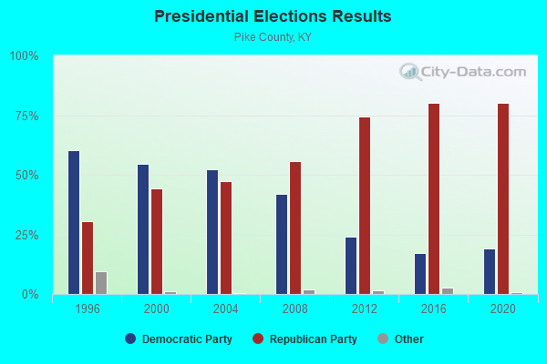
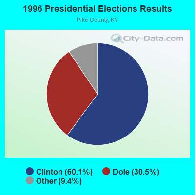
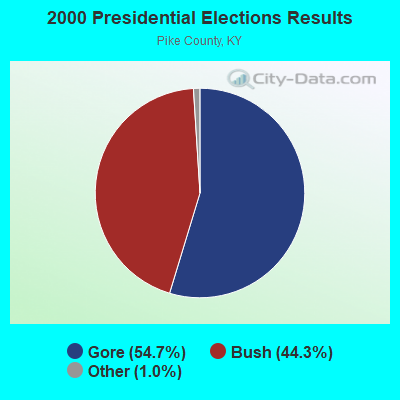
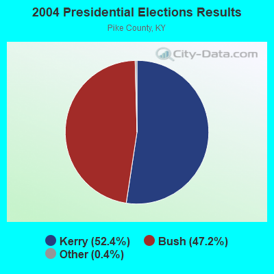
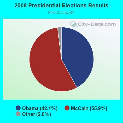
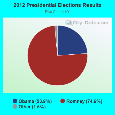
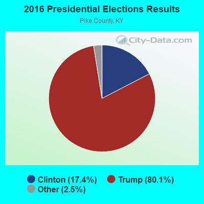
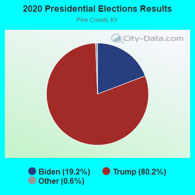
Graphs represent county-level data. Detailed 2008 Election Results
Religion statistics for Dorton, KY (based on Pike County data)
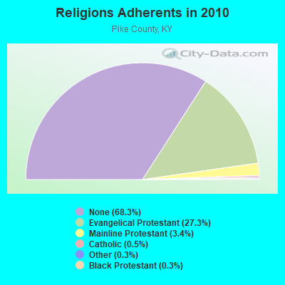
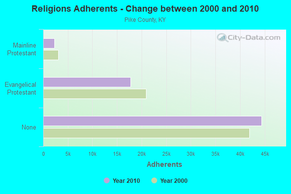
| Religion | Adherents | Congregations |
|---|---|---|
| Evangelical Protestant | 17,720 | 101 |
| Mainline Protestant | 2,227 | 15 |
| Catholic | 293 | 3 |
| Other | 213 | 3 |
| Black Protestant | 180 | 1 |
| None | 44,391 | - |
Food Environment Statistics:
| Pike County: | 3.51 / 10,000 pop. |
| Kentucky: | 2.19 / 10,000 pop. |
| Here: | 0.31 / 10,000 pop. |
| Kentucky: | 0.25 / 10,000 pop. |
| This county: | 0.31 / 10,000 pop. |
| State: | 0.74 / 10,000 pop. |
| Pike County: | 3.82 / 10,000 pop. |
| State: | 4.36 / 10,000 pop. |
| Here: | 4.12 / 10,000 pop. |
| Kentucky: | 5.74 / 10,000 pop. |
| This county: | 15.7% |
| State: | 11.0% |
| This county: | 33.3% |
| Kentucky: | 30.0% |
| Pike County: | 13.1% |
| Kentucky: | 15.9% |
Strongest AM radio stations in Dorton:
- WLSI (900 AM; 5 kW; PIKEVILLE, KY; Owner: EAST KENTUCKY BROADCASTING CORPORATION)
- WEZC (1480 AM; daytime; 5 kW; NEON, KY; Owner: JESUS COMMUNICATION ILNC.)
- WTCW (920 AM; 4 kW; WHITESBURG, KY; Owner: T.C.W. BROADCASTING , INC.)
- WDIC (1430 AM; daytime; 5 kW; CLINCHCO, VA; Owner: DICKENSON COUNTY BROADCASTING CORP.)
- WBPA (1460 AM; 5 kW; ELKHORN CITY, KY; Owner: EAST KENTUCKY BROADCASTING CORP)
- WKVG (1000 AM; daytime; 1 kW; JENKINS, KY; Owner: MARTINS & ASSOCIATES, INC.)
- WNVA (1350 AM; 5 kW; NORTON, VA; Owner: RADIO-WISE, INC.)
- WNRG (940 AM; 5 kW; GRUNDY, VA; Owner: VIRGINIA-KENTUCKY BROADCASTING CO., INC)
- WPRT (960 AM; 5 kW; PRESTONSBURG, KY; Owner: EAST KENTUCKY RADIO NETWORK, INC.)
- WKYH (600 AM; 5 kW; PAINTSVILLE, KY; Owner: HIGHLANDS BROADCASTING CORPORATION)
- WZAP (690 AM; 10 kW; BRISTOL, VA; Owner: RAM COMMUNICATIONS, INC.)
- WGOC (640 AM; 10 kW; BLOUNTVILLE, TN; Owner: CITADEL BROADCASTING COMPANY)
- WKVL (850 AM; daytime; 50 kW; KNOXVILLE, TN; Owner: HORNE RADIO, LLC)
Strongest FM radio stations in Dorton:
- WDXC (102.3 FM; POUND, VA; Owner: WDXC RADIO, INC.)
- WZLK (107.5 FM; VIRGIE, KY; Owner: EAST KENTUCKY BROADCASTING CORPORATION)
- WPKE-FM (103.1 FM; COAL RUN, KY; Owner: EAST KENTUCKY BROADCASTING CORP.)
- WIFX-FM (94.3 FM; JENKINS, KY; Owner: LETCHER COUNTY BROADCASTING, INC)
- WXKQ-FM (103.9 FM; WHITESBURG, KY; Owner: T.C.W. BROADCASTING , INC.)
- WMMT (88.7 FM; WHITESBURG, KY; Owner: APPALSHOP, INCORPORATED)
- WDHR (93.1 FM; PIKEVILLE, KY; Owner: EAST KENTUCKY BROADCASTING CORP.)
- WXLR (104.9 FM; HAROLD, KY; Owner: ADAM D GEARHEART)
- WAXM (93.5 FM; BIG STONE GAP, VA; Owner: VALLEY BROADCASTING, INC.)
- WSEH (102.7 FM; CUMBERLAND, KY; Owner: CUMBERLAND CITY BROADCASTING, INC.)
- WDIC-FM (92.1 FM; CLINCHCO, VA; Owner: DICKENSON COUNTY BROADCASTING CORP.)
- W223AA (92.5 FM; BIG STONE GAP, VA; Owner: VALLEY BROADCASTING, INC.)
- WJSO (90.1 FM; PIKEVILLE, KY; Owner: THE MOODY BIBLE INSTITUTE OF CHICAGO)
- W251AI (98.1 FM; PIKEVILLE, KY; Owner: EAST KENTUCKY BROADCASTING CORPORATION)
- WSGS (101.1 FM; HAZARD, KY; Owner: MOUNTAIN BROADCASTING SERVICE, INC.)
- WWJD (91.7 FM; PIPPA PASSES, KY; Owner: ALICE LLOYD COLLEGE)
- WTFM (98.5 FM; KINGSPORT, TN; Owner: HOLSTON VALLEY BROADCASTING CORP.)
- WKCB-FM (107.1 FM; HINDMAN, KY; Owner: HINDMAN BROADCASTING CORPORATION)
- WZQQ (97.9 FM; HYDEN, KY; Owner: LESLIE COUNTY BROADCASTING, INC.)
- WQHY (95.5 FM; PRESTONSBURG, KY; Owner: WDOC, INC.)
TV broadcast stations around Dorton:
- WKPI-TV (Channel 22; PIKEVILLE, KY; Owner: KENTUCKY AUTHORITY FOR EDUCATIONAL TV)
- WYMT-TV (Channel 57; HAZARD, KY; Owner: WYMT LICENSEE CORP.)
- W24BT (Channel 24; TALBERT, KY; Owner: MS COMMUNICATIONS, LLC)
- W26BK (Channel 26; TALBERT, KY; Owner: MS COMMUNICATIONS, LLC)
- W31BU (Channel 31; TALBERT, KY; Owner: MS COMMUNICATIONS, LLC)
- W53BQ (Channel 53; TALBERT, KY; Owner: MS COMMUNICATIONS, LLC)
- W69ED (Channel 69; TALBERT, KY; Owner: MS COMMUNICATIONS, LLC)
- WKHA (Channel 35; HAZARD, KY; Owner: KENTUCKY AUTHORITY FOR EDUCATIONAL TV)

FCC Registered Cell Phone Towers:
3 (See the full list of FCC Registered Cell Phone Towers in Dorton)FCC Registered Antenna Towers:
39 (See the full list of FCC Registered Antenna Towers)FCC Registered Private Land Mobile Towers:
1 (See the full list of FCC Registered Private Land Mobile Towers in Dorton, KY)FCC Registered Broadcast Land Mobile Towers:
10 (See the full list of FCC Registered Broadcast Land Mobile Towers)FCC Registered Microwave Towers:
6- FLATWOOD, Flatwood Mtn., 7.1 Km East Of (Lat: 37.287583 Lon: -82.500694), Type: Tower, Structure height: 54.9 m, Overall height: 59.1 m, Call Sign: WMQ944,
Assigned Frequencies: 6675.00 MHz, 6330.66 MHz, 6330.66 MHz, 6330.66 MHz, 6330.66 MHz, 6330.66 MHz, 6330.66 MHz, 6389.96 MHz, 6389.96 MHz, 6389.96 MHz... (+3 more), Grant Date: 03/02/2021, Expiration Date: 02/01/2031, Certifier: Paul R Gearheart, Registrant: East Kentucky Network, LLC D/B/A Appalachian Wireless, 101 Technology Trail, Ivel, KY 41642, Phone: (606) 339-1006, Fax: (606) 339-1363, Email:
- STATION, 2.95 Mi Ene Of (Lat: 37.285083 Lon: -82.526528), Overall height: 54.9 m, Call Sign: WNTN369,
Assigned Frequencies: 953.750 MHz, Grant Date: 03/16/2002, Expiration Date: 05/29/2012, Cancellation Date: 08/04/2012, Certifier: Lester A Zitkus, Registrant: Keller And Heckman LLP, 1001 G Street Nw, Suite 500 West, Washington, DC 20001, Phone: (202) 434-4282, Fax: (202) 434-4646, Email:
- HIGHWAY 23, Ky Hwy 611 3 Mi E Of Us Rte 23 (Lat: 37.314694 Lon: -82.503306), Type: Tower, Structure height: 122.2 m, Overall height: 126.2 m, Call Sign: WPNC543,
Assigned Frequencies: 2165.20 MHz, Grant Date: 12/28/2010, Expiration Date: 02/01/2021, Cancellation Date: 08/05/2013, Certifier: Carol L Tacker, Registrant: At&t Mobility LLC, 2200 N. Greenville Ave #1w, Richardson, TX 70582, Phone: (972) 234-7003, Fax: (972) 301-6893, Email:
- FLATWOODS TS, Lat: 37.286222 Lon: -82.528500, Type: Tower, Structure height: 45.7 m, Overall height: 49.7 m, Call Sign: WQKM631,
Assigned Frequencies: 3650.00 MHz, Grant Date: 06/05/2019, Expiration Date: 10/17/2020, Cancellation Date: 12/19/2020, Certifier: Jason D Griffith, Registrant: American Electric Power Service Corporation, 850 Tech Center Drive, Gahanna, OH 43230, Phone: (614) 883-7265, Fax: (614) 883-6917, Email:
- FLATWOODS, Lat: 37.285083 Lon: -82.526583, Type: Gtower, Structure height: 30 m, Overall height: 55 m, Call Sign: WQUW788,
Assigned Frequencies: 3650.00 MHz, Grant Date: 11/04/2014, Expiration Date: 11/04/2024, Certifier: Cary V Johnson, Registrant: Tri-State Electronics, Inc., 640 Four Mile Road, Baxter, KY 40806, Phone: (606) 273-9464, Email:
- Flatwoods, Lat: 37.285083 Lon: -82.526583, Type: Nngtann, Structure height: 30 m, Overall height: 55 m, Call Sign: WQUW788,
Assigned Frequencies: 3650.00 MHz, Grant Date: 11/04/2014, Expiration Date: 11/04/2024, Certifier: Cary V Johnson, Registrant: Tri-State Electronics, Inc., 640 Four Mile Road, Baxter, KY 40806, Phone: (606) 273-9464, Email:
FCC Registered Paging Towers:
1- Flatswoods Mountain, 2.5 Miles West Of (Lat: 37.285083 Lon: -82.524583), Call Sign: KNKL504,
Assigned Frequencies: 152.780 MHz, 75.8000 MHz, Expiration Date: 04/01/1999, Cancellation Date: 06/05/1999, Registrant: Gerald Delong Dba: East Kentucky Mobile Telephone Company, Pikeville, KY 41501-4336, Phone: (202) 223-4664
FCC Registered Amateur Radio Licenses:
1- Call Sign: KG4UQJ, Licensee ID: L00556568, Grant Date: 08/09/2002, Expiration Date: 08/09/2012, Cancellation Date: 08/12/2014, Certifier: Homer-Darrel S Collier, Registrant: Homer-Darrel S Collier, Dorton, KY 41520
FAA Registered Aircraft:
1- Aircraft: BELL 407 (Category: Land, Seats: 7, Weight: Up to 12,499 Pounds), Engine: ALLISON 250-C47 (600 HP) (Turbo-shaft)
N-Number: 859JR, N859JR, N-859JR, Serial Number: 53201, Year manufactured: 1997, Airworthiness Date: 11/10/1997, Certificate Issue Date: 12/10/2019
Registrant (LLC): W&l LLC, Po Box 358, Dorton, KY 41520

- 65.7%Electricity
- 27.7%Utility gas
- 2.5%Coal or coke
- 1.9%Bottled, tank, or LP gas
- 1.1%Fuel oil, kerosene, etc.
- 0.5%Wood
- 0.5%No fuel used

- 62.1%Electricity
- 19.2%Utility gas
- 7.4%Fuel oil, kerosene, etc.
- 6.4%Bottled, tank, or LP gas
- 4.9%Coal or coke
Dorton compared to Kentucky state average:
- Median house value below state average.
- Black race population percentage significantly below state average.
- Hispanic race population percentage significantly below state average.
- Foreign-born population percentage significantly below state average.
- Renting percentage below state average.
- Length of stay since moving in significantly above state average.
- Number of rooms per house significantly below state average.
- House age significantly below state average.
- Percentage of population with a bachelor's degree or higher significantly below state average.

|
Total of 1 patent application in 2008-2024.