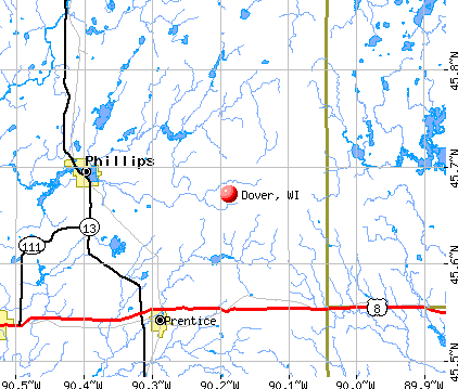
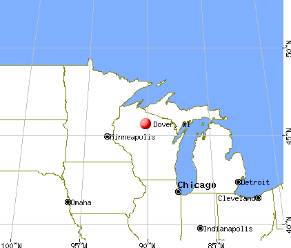
Dover, Wisconsin
Submit your own pictures of this town and show them to the world
- OSM Map
- General Map
- Google Map
- MSN Map
Population change since 2000: +3.7%
 |
| Males: 1,994 | |
| Females: 2,057 |
| Median resident age: | 44.3 years |
| Wisconsin median age: | 42.6 years |
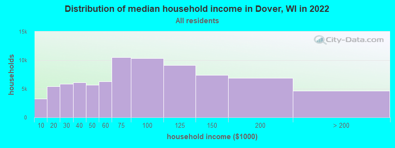
| Dover: | $74,646 |
| WI: | $70,996 |
Estimated per capita income in 2022: $35,210 (it was $20,275 in 2000)
Dover town income, earnings, and wages data
Estimated median house or condo value in 2022: $307,153 (it was $142,100 in 2000)
| Dover: | $307,153 |
| WI: | $252,800 |
Mean prices in 2022: all housing units: $275,174; detached houses: $274,857; townhouses or other attached units: $400,495; in 2-unit structures: $198,989; in 3-to-4-unit structures: $358,139; in 5-or-more-unit structures: $173,772; mobile homes: $100,499
Detailed information about poverty and poor residents in Dover, WI


- 3,70091.3%White alone
- 1443.6%Hispanic
- 1273.1%Black alone
- 340.8%American Indian alone
- 250.6%Two or more races
- 200.5%Asian alone
- 10.02%Native Hawaiian and Other
Pacific Islander alone
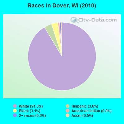
Races in Dover detailed stats: ancestries, foreign born residents, place of birth
 Recent articles from our blog. Our writers, many of them Ph.D. graduates or candidates, create easy-to-read articles on a wide variety of topics.


 | Scott Walker or Mary Burke? (210 replies) |
| Family Moving from St Louis to Milwaukee- Need Advice (39 replies) |
| Weather in Madison/Sun Prairie? (20 replies) |
| Crime in Madison.... (103 replies) |
| Roadtrip from Toronto to Milwaukee on a budget (9 replies) |
| To the people of wisconsin (61 replies) |
Latest news from Dover, WI collected exclusively by city-data.com from local newspapers, TV, and radio stations
Ancestries: German (33.9%), English (9.3%), Irish (9.3%), Polish (7.5%), Italian (6.2%), United States (4.6%).
Current Local Time: CST time zone
Elevation: 1660 feet
Land area: 35.4 square miles.
Population density: 115 people per square mile (very low).
59 residents are foreign born
| This town: | 1.5% |
| Wisconsin: | 3.6% |
| Dover town: | 1.6% ($2,250) |
| Wisconsin: | 2.0% ($2,245) |
Nearest city with pop. 50,000+: Racine, WI  (16.3 miles , pop. 81,855).
Nearest city with pop. 200,000+: Milwaukee, WI (25.1 miles , pop. 596,974).
Nearest city with pop. 1,000,000+: Chicago, IL (64.5 miles , pop. 2,896,016).
Nearest cities:
), ), ), ), )Latitude: 42.71 N, Longitude: 88.13 W
Area code commonly used in this area: 262

| Here: | 3.1% |
| Wisconsin: | 2.7% |
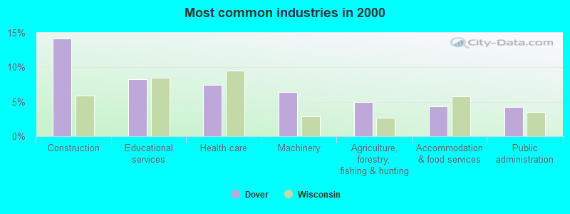
- Construction (14.1%)
- Educational services (8.3%)
- Health care (7.4%)
- Machinery (6.4%)
- Agriculture, forestry, fishing & hunting (5.0%)
- Accommodation & food services (4.4%)
- Public administration (4.2%)
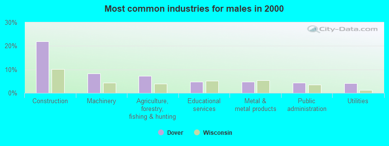
- Construction (21.9%)
- Machinery (8.2%)
- Agriculture, forestry, fishing & hunting (7.3%)
- Educational services (4.8%)
- Metal & metal products (4.7%)
- Public administration (4.3%)
- Utilities (4.2%)
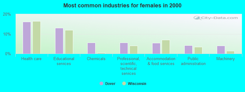
- Health care (16.2%)
- Educational services (13.0%)
- Chemicals (5.5%)
- Professional, scientific, technical services (5.5%)
- Accommodation & food services (5.4%)
- Public administration (4.1%)
- Machinery (4.0%)
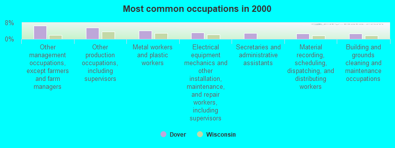
- Other management occupations, except farmers and farm managers (6.5%)
- Other production occupations, including supervisors (5.5%)
- Metal workers and plastic workers (4.2%)
- Electrical equipment mechanics and other installation, maintenance, and repair workers, including supervisors (3.3%)
- Secretaries and administrative assistants (2.9%)
- Material recording, scheduling, dispatching, and distributing workers (2.7%)
- Building and grounds cleaning and maintenance occupations (2.6%)
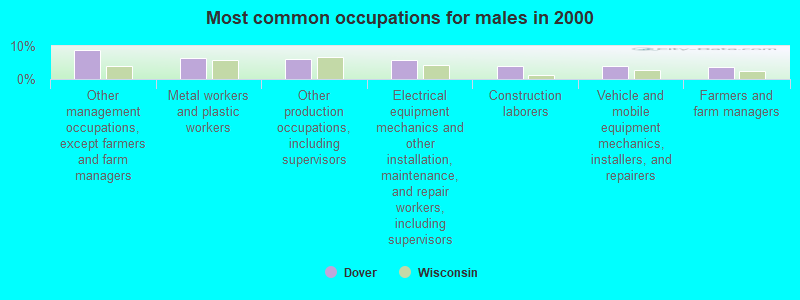
- Other management occupations, except farmers and farm managers (8.9%)
- Metal workers and plastic workers (6.2%)
- Other production occupations, including supervisors (5.9%)
- Electrical equipment mechanics and other installation, maintenance, and repair workers, including supervisors (5.7%)
- Construction laborers (4.1%)
- Vehicle and mobile equipment mechanics, installers, and repairers (4.0%)
- Farmers and farm managers (3.8%)
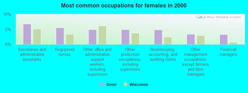
- Secretaries and administrative assistants (6.8%)
- Registered nurses (5.5%)
- Other office and administrative support workers, including supervisors (5.0%)
- Other production occupations, including supervisors (5.0%)
- Bookkeeping, accounting, and auditing clerks (4.8%)
- Other management occupations, except farmers and farm managers (3.5%)
- Financial managers (3.3%)
Average climate in Dover, Wisconsin
Based on data reported by over 4,000 weather stations


(lower is better)
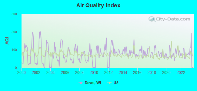
Air Quality Index (AQI) level in 2022 was 74.1. This is about average.
| City: | 74.1 |
| U.S.: | 72.6 |
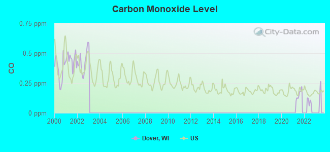
Carbon Monoxide (CO) [ppm] level in 2021 was 0.153. This is significantly better than average. Closest monitor was 16.3 miles away from the city center.
| City: | 0.153 |
| U.S.: | 0.251 |
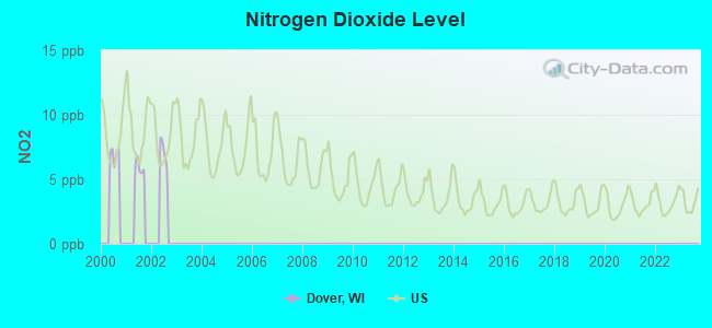
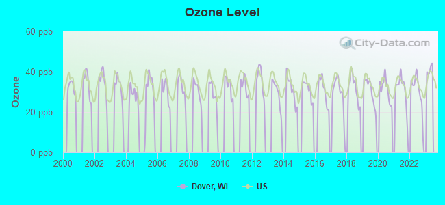
Ozone [ppb] level in 2022 was 30.4. This is about average. Closest monitor was 4.3 miles away from the city center.
| City: | 30.4 |
| U.S.: | 33.3 |
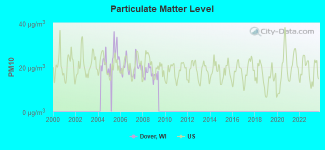
Particulate Matter (PM10) [µg/m3] level in 2008 was 17.3. This is about average. Closest monitor was 16.7 miles away from the city center.
| City: | 17.3 |
| U.S.: | 19.2 |
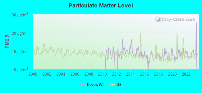
Particulate Matter (PM2.5) [µg/m3] level in 2022 was 7.74. This is about average. Closest monitor was 18.1 miles away from the city center.
| City: | 7.74 |
| U.S.: | 8.11 |
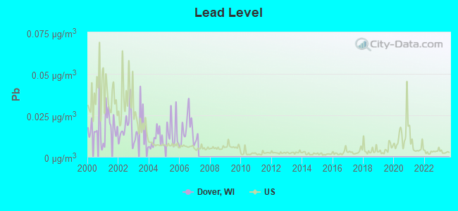
Lead (Pb) [µg/m3] level in 2006 was 0.0169. This is significantly worse than average. Closest monitor was 4.5 miles away from the city center.
| City: | 0.0169 |
| U.S.: | 0.0093 |
Tornado activity:
Dover-area historical tornado activity is slightly above Wisconsin state average. It is 29% greater than the overall U.S. average.
On 4/27/1984, a category F4 (max. wind speeds 207-260 mph) tornado 22.3 miles away from the Dover town center killed one person and injured 14 people and caused between $500,000 and $5,000,000 in damages.
On 9/28/1972, a category F4 tornado 28.1 miles away from the town center injured 20 people and caused between $500,000 and $5,000,000 in damages.
Earthquake activity:
Dover-area historical earthquake activity is significantly above Wisconsin state average. It is 22% greater than the overall U.S. average.On 4/18/2008 at 09:36:59, a magnitude 5.4 (5.1 MB, 4.8 MS, 5.4 MW, 5.2 MW, Class: Moderate, Intensity: VI - VII) earthquake occurred 294.9 miles away from the city center
On 6/10/1987 at 23:48:54, a magnitude 5.1 (4.9 MB, 4.4 MS, 4.6 MS, 5.1 LG) earthquake occurred 269.4 miles away from Dover center
On 6/28/2004 at 06:10:52, a magnitude 4.2 (4.2 MW, Depth: 6.2 mi, Class: Light, Intensity: IV - V) earthquake occurred 95.3 miles away from the city center
On 4/18/2008 at 09:36:59, a magnitude 5.2 (5.2 MW, Depth: 8.9 mi) earthquake occurred 295.0 miles away from the city center
On 2/10/2010 at 09:59:35, a magnitude 3.8 (3.8 MW, Depth: 6.2 mi, Class: Light, Intensity: II - III) earthquake occurred 54.8 miles away from Dover center
On 5/2/2015 at 16:23:07, a magnitude 4.2 (4.2 MW, Depth: 2.8 mi) earthquake occurred 141.5 miles away from the city center
Magnitude types: regional Lg-wave magnitude (LG), body-wave magnitude (MB), surface-wave magnitude (MS), moment magnitude (MW)
Natural disasters:
The number of natural disasters in Racine County (15) is near the US average (15).Major Disasters (Presidential) Declared: 11
Emergencies Declared: 4
Causes of natural disasters: Floods: 9, Storms: 8, Tornadoes: 3, Winter Storms: 3, Snowstorms: 2, Blizzard: 1, Hurricane: 1, Snow: 1, Other: 1 (Note: some incidents may be assigned to more than one category).

Hospitals and medical centers near Dover:
- SOUTHERN WI CTR FDD (Hospital, about 3 miles away; UNION GROVE, WI)
- WI VETERANS HOME-BOLAND HALL (Nursing Home, about 3 miles away; UNION GROVE, WI)
- LAKEVIEW SPECIALTY HOSPITAL AND REHAB CENTER (Hospital, about 3 miles away; WATERFORD, WI)
- MIDWEST REHAB CENTER (Nursing Home, about 3 miles away; WATERFORD, WI)
- OAK RIDGE CARE CTR (Nursing Home, about 4 miles away; UNION GROVE, WI)
- KINDRED NURSING AND REHAB-BURLINGTON (Nursing Home, about 8 miles away; BURLINGTON, WI)
- MOUNT CARMEL CARE CENTER (Nursing Home, about 8 miles away; BURLINGTON, WI)
Colleges/universities with over 2000 students nearest to Dover:
- University of Wisconsin-Parkside (about 15 miles; Kenosha, WI; Full-time enrollment: 3,843)
- Gateway Technical College (about 17 miles; Kenosha, WI; FT enrollment: 5,089)
- Carthage College (about 17 miles; Kenosha, WI; FT enrollment: 3,130)
- Carroll University (about 21 miles; Waukesha, WI; FT enrollment: 3,313)
- Marquette University (about 25 miles; Milwaukee, WI; FT enrollment: 9,844)
- Milwaukee Area Technical College (about 26 miles; Milwaukee, WI; FT enrollment: 13,156)
- College of Lake County (about 26 miles; Grayslake, IL; FT enrollment: 11,041)
Points of interest:
Notable locations in Dover: Pan-Yak Golf Course (A), Southern Wisconsin Center (B), Kansasville Fire and Rescue Department (C), Lakeview Rehabilitation Center (D). Display/hide their locations on the map
Church in Dover: Saint Mary Church (A). Display/hide its location on the map
Lake: Eagle Lake (A). Display/hide its location on the map
Parks in Dover include: Beaumont Park (1), Eagle Lake Park (2). Display/hide their locations on the map
| This town: | 2.5 people |
| Wisconsin: | 2.4 people |
| This town: | 70.9% |
| Whole state: | 64.4% |
| This town: | 7.5% |
| Whole state: | 7.3% |
Likely homosexual households (counted as self-reported same-sex unmarried-partner households)
- Lesbian couples: 0.4% of all households
- Gay men: 0.3% of all households
| This town: | 11.2% |
| Whole state: | 8.7% |
| This town: | 5.4% |
| Whole state: | 3.7% |
People in group quarters in Dover in 2010:
- 297 people in nursing facilities/skilled-nursing facilities
- 274 people in state prisons
- 53 people in correctional facilities intended for juveniles
- 41 people in group homes intended for adults
- 10 people in residential treatment centers for adults
- 8 people in workers' group living quarters and job corps centers
People in group quarters in Dover in 2000:
- 519 people in other nonhousehold living situations
- 86 people in unknown juvenile institutions
- 52 people in hospitals/wards and hospices for chronically ill
- 52 people in other hospitals or wards for chronically ill
- 6 people in homes for the mentally ill
For population 15 years and over in Dover:
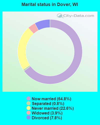
- Never married: 22.6%
- Now married: 64.8%
- Separated: 0.8%
- Widowed: 3.9%
- Divorced: 7.8%
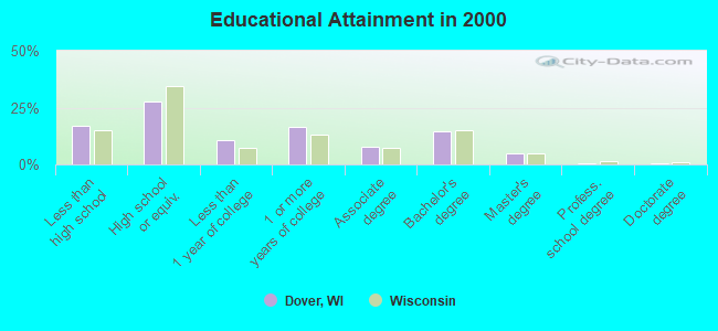
For population 25 years and over in Dover:
- High school or higher: 82.9%
- Bachelor's degree or higher: 20.2%
- Graduate or professional degree: 5.7%
- Unemployed: 24.6%
- Mean travel time to work (commute): 24.9 minutes
| Here: | 9.4 |
| Wisconsin average: | 11.0 |
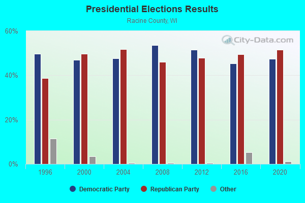
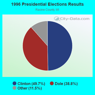
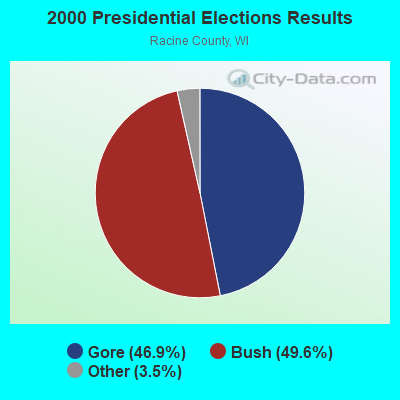
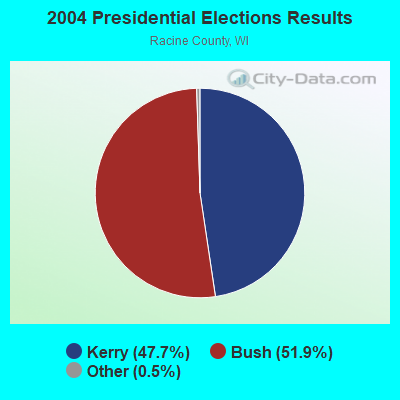
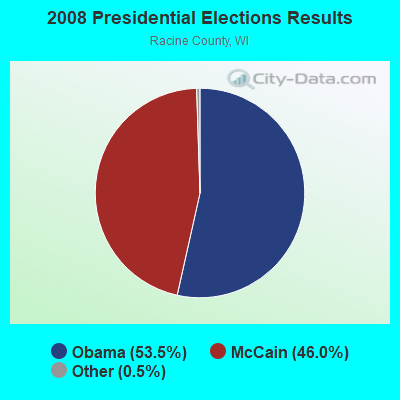
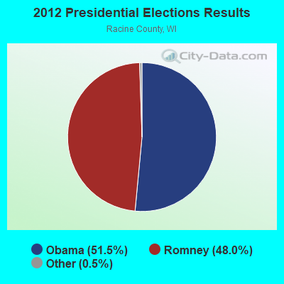
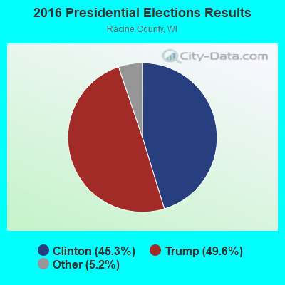
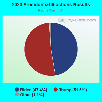
Graphs represent county-level data. Detailed 2008 Election Results
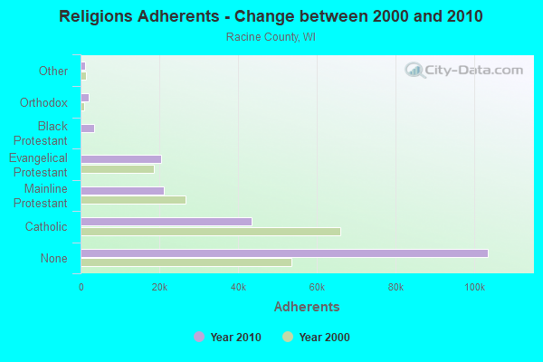
Religion statistics for Dover, WI (based on Racine County data)
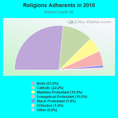
| Religion | Adherents | Congregations |
|---|---|---|
| Catholic | 43,335 | 21 |
| Mainline Protestant | 21,224 | 48 |
| Evangelical Protestant | 20,564 | 79 |
| Black Protestant | 3,520 | 14 |
| Orthodox | 2,020 | 5 |
| Other | 1,213 | 10 |
| None | 103,532 | - |
Food Environment Statistics:
| Racine County: | 1.86 / 10,000 pop. |
| State: | 1.86 / 10,000 pop. |
| Racine County: | 0.10 / 10,000 pop. |
| State: | 0.11 / 10,000 pop. |
| Racine County: | 0.35 / 10,000 pop. |
| Wisconsin: | 0.38 / 10,000 pop. |
| Here: | 3.52 / 10,000 pop. |
| Wisconsin: | 4.12 / 10,000 pop. |
| Racine County: | 6.28 / 10,000 pop. |
| Wisconsin: | 8.64 / 10,000 pop. |
| This county: | 8.3% |
| Wisconsin: | 7.6% |
| Racine County: | 28.0% |
| Wisconsin: | 27.5% |
| Racine County: | 13.3% |
| Wisconsin: | 13.0% |
Strongest AM radio stations in Dover:
- WTMJ (620 AM; 50 kW; MILWAUKEE, WI; Owner: JOURNAL BROADCAST CORPORATION)
- WISN (1130 AM; 50 kW; MILWAUKEE, WI; Owner: CAPSTAR TX LIMITED PARTNERSHIP)
- WGN (720 AM; 50 kW; CHICAGO, IL; Owner: WGN CONTINENTAL BROADCASTING CO.)
- WBBM (780 AM; 50 kW; CHICAGO, IL; Owner: INFINITY BROADCASTING OPERATIONS, INC.)
- WSCR (670 AM; 50 kW; CHICAGO, IL; Owner: INFINITY BROADCASTING OPERATIONS, INC.)
- WOKY (920 AM; 5 kW; MILWAUKEE, WI; Owner: CLEAR CHANNEL BROADCASTING LICENSES, INC.)
- WMCS (1290 AM; 5 kW; GREENFIELD, WI; Owner: MILWAUKEE RADIO ALLIANCE, LLC)
- WEMP (1250 AM; 5 kW; MILWAUKEE, WI; Owner: ENTERCOM MILWAUKEE LICENSE, LLC)
- WAUK (1510 AM; daytime; 10 kW; WAUKESHA, WI; Owner: WALT-WEST WISCONSIN, INC.)
- WMVP (1000 AM; 50 kW; CHICAGO, IL; Owner: ABC, INC.)
- WKSH (1640 AM; 10 kW; SUSSEX, WI; Owner: ABC, INC.)
- WLS (890 AM; 50 kW; CHICAGO, IL; Owner: WLS, INC.)
- WYLL (1160 AM; 50 kW; CHICAGO, IL; Owner: SCA LICENSE CORPORATION)
Strongest FM radio stations in Dover:
- WKKV-FM (100.7 FM; RACINE, WI; Owner: CLEAR CHANNEL BROADCASTING LICENSES, INC.)
- WEZY (92.1 FM; RACINE, WI; Owner: RACINE BROADCASTING, L.L.C.)
- WFZH (105.3 FM; MUKWONAGO, WI; Owner: CARON BROADCASTING, INC.)
- WVCY-FM (107.7 FM; MILWAUKEE, WI; Owner: VCY AMERICA, INC.)
- WEXT (104.7 FM; STURTEVANT, WI; Owner: NM LICENSING, LLC)
- WJZI (93.3 FM; MILWAUKEE, WI; Owner: MILWAUKEE RADIO ALLIANCE, LLC)
- WMIL-FM (106.1 FM; WAUKESHA, WI; Owner: CLEAR CHANNEL BROADCASTING LICENSES, INC.)
- WKTI-FM (94.5 FM; MILWAUKEE, WI; Owner: JOURNAL BROADCAST CORPORATION)
- WMYX-FM (99.1 FM; MILWAUKEE, WI; Owner: ENTERCOM MILWAUKEE LICENSE, LLC)
- WLTQ (97.3 FM; MILWAUKEE, WI; Owner: CAPSTAR TX LIMITED PARTNERSHIP)
- WWDV (96.9 FM; ZION, IL; Owner: BONNEVILLE HOLDING COMPANY)
- WUWM (89.7 FM; MILWAUKEE, WI; Owner: BOARD OF REGENTS, UNIVERSITY OF WISCONSIN SYSTEM)
- WXSS (103.7 FM; WAUWATOSA, WI; Owner: ENTERCOM MILWAUKEE LICENSE, LLC)
- WIIL (95.1 FM; KENOSHA, WI; Owner: NM LICENSING, LLC)
- WHAD (90.7 FM; DELAFIELD, WI; Owner: STATE OF WISCONSIN - EDUCATIONAL COMMUNICATIONS BOARD)
- WKLH (96.5 FM; MILWAUKEE, WI; Owner: LAKEFRONT COMMUNICATIONS, LLC)
- WMWK (88.1 FM; MILWAUKEE, WI; Owner: FAMILY STATIONS, INC.)
- WLUM-FM (102.1 FM; MILWAUKEE, WI; Owner: MILWAUKEE RADIO ALLIANCE, LLC)
- WLKG (96.1 FM; LAKE GENEVA, WI; Owner: CTJ COMMUNICATIONS, LTD.)
- WRIT-FM (95.7 FM; MILWAUKEE, WI; Owner: CLEAR CHANNEL BROADCASTING LICENSES, INC.)
TV broadcast stations around Dover:
- WJJA (Channel 49; RACINE, WI; Owner: TV-49, INC.)
- W64CQ (Channel 64; ARLINGTON HEIGHTS, IL; Owner: TRINITY BROADCASTING NETWORK)
- WPXE (Channel 55; KENOSHA, WI; Owner: PAXSON MILWAUKEE LICENSE, INC.)
- WMVS (Channel 10; MILWAUKEE, WI; Owner: MILWAUKEE AREA TECHNICAL COLLEGE DISTRICT BOARD)
- WMVT (Channel 36; MILWAUKEE, WI; Owner: MILWAUKEE AREA TECHNICAL COLLEGE DISTRICT BOARD)
- WDJT-TV (Channel 58; MILWAUKEE, WI; Owner: WDJT-TV LIMITED PARTNERSHIP)
- WISN-TV (Channel 12; MILWAUKEE, WI; Owner: WISN HEARST-ARGYLE TV, INC. (CA CORP.))
- WCGV-TV (Channel 24; MILWAUKEE, WI; Owner: WCGV LICENSEE, LLC)
- WTMJ-TV (Channel 4; MILWAUKEE, WI; Owner: JOURNAL BROADCAST CORPORATION)
- WVTV (Channel 18; MILWAUKEE, WI; Owner: WVTV LICENSEE, INC.)
- WMLW-CA (Channel 46; MILWAUKEE, WI; Owner: CHANNEL 41 AND 63 LIMITED PARTNERSHIP)
- W63CU (Channel 63; MILWAUKEE, WI; Owner: CHANNEL 41 AND 63 LIMITED PARTNERSHIP)
- WVCY-TV (Channel 30; MILWAUKEE, WI; Owner: VCY AMERICA, INC.)
- WMKE-CA (Channel 7; MILWAUKEE, WI; Owner: KM LPTV OF MILWAUKEE, L.L.C.)
- W34CK (Channel 34; ARLINGTON HEIGHTS, IL; Owner: FIRST UNITED, INC.)
- WITI (Channel 6; MILWAUKEE, WI; Owner: WITI LICENSE,INC.)
- WTAS-LP (Channel 43; WAUKESHA, WI; Owner: WAUKESHA TOWER ASSOCIATES)
- WGBO-TV (Channel 66; JOLIET, IL; Owner: WGBO LICENSE PARTNERSHIP, G.P.)
FCC Registered Cell Phone Towers:
1 (See the full list of FCC Registered Cell Phone Towers in Dover)FCC Registered Antenna Towers:
11 (See the full list of FCC Registered Antenna Towers)FCC Registered Broadcast Land Mobile Towers:
1- 2.1 Mi E On Cth D 200 N (Lat: 45.672167 Lon: -90.145139), Call Sign: WNSU421, Licensee ID: L00314298,
Assigned Frequencies: 460.800 MHz, Grant Date: 04/30/2005, Expiration Date: 07/12/2015, Cancellation Date: 12/18/2012, Certifier: Vicki Schultheis, Registrant: Centurytel Of Northern Wisconsin, LLC, 805 Broadway Suite 800, Vancouver, WA 98660, Phone: (360) 905-6839, Fax: (360) 905-5953, Email:
FCC Registered Microwave Towers:
3- DREAMLAND, 2421 Mealy Road (Lat: 42.748056 Lon: -88.153056), Type: Gtower, Structure height: 91.4 m, Overall height: 96 m, Call Sign: WML773,
Assigned Frequencies: 6004.50 MHz, 10835.0 MHz, 6152.75 MHz, 6093.45 MHz, Grant Date: 12/29/2020, Expiration Date: 02/01/2031, Certifier: John E Rooney, Registrant: Wilkinson Barker Knauer, LLP, 1800 M Street Nw, Suite 800n, Washington, DC 20036, Phone: (202) 383-3420, Fax: (202) 783-5851, Email:
- STATION, On Cth D & 200' N 2.1 Mi E Of (Lat: 45.672167 Lon: -90.145139), Overall height: 57.9 m, Call Sign: WNEW770,
Assigned Frequencies: 22075.0 MHz, 6650.00 MHz, 21975.0 MHz, 6605.00 MHz, 22175.0 MHz, 22275.0 MHz, Grant Date: 01/07/2020, Expiration Date: 01/24/2030, Registrant: Northcentral Technical College, 1000 W Campus Dr, Wausau, WI 54401, Phone: (715) 803-1112, Email:
- WISN TRANSMITTER SIT, 21423 Bennett Rd (Lat: 42.755833 Lon: -88.083333), Type: Other, Structure height: 68.2 m, Overall height: 69.5 m, Call Sign: WQDE431,
Assigned Frequencies: 956.000 MHz, Grant Date: 08/04/2005, Expiration Date: 08/04/2015, Cancellation Date: 05/18/2015, Certifier: Andrew W Levin, Registrant: Iheartmedia, 2625 South Memorial Drive, Suite A, Tulsa, OK 74129, Phone: (918) 664-4581, Fax: (918) 664-3066, Email:
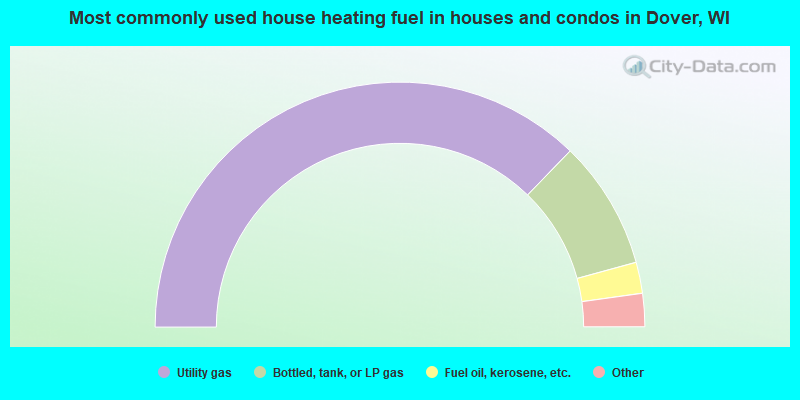
- 74.4%Utility gas
- 17.0%Bottled, tank, or LP gas
- 4.1%Fuel oil, kerosene, etc.
- 3.0%Wood
- 1.5%Electricity
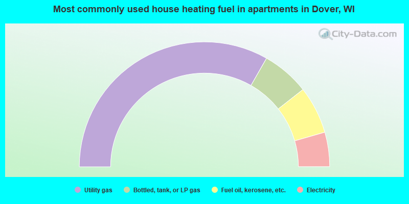
- 66.5%Utility gas
- 12.3%Bottled, tank, or LP gas
- 12.3%Fuel oil, kerosene, etc.
- 8.9%Electricity
Dover compared to Wisconsin state average:
- Unemployed percentage above state average.
- Black race population percentage below state average.
- Hispanic race population percentage below state average.
- Foreign-born population percentage significantly below state average.
- Renting percentage below state average.
- Length of stay since moving in significantly above state average.
- Number of rooms per house significantly below state average.
- House age significantly below state average.
- Institutionalized population percentage significantly above state average.
Dover on our top lists:
- #2 on the list of "Top 101 cities with the largest percentage of people in other nonhousehold living situations (population 1,000+)"
- #15 on the list of "Top 101 cities with the largest percentage of people in unknown juvenile institutions (population 1,000+)"
- #25 on the list of "Top 101 cities with the largest percentage of people in other hospitals or wards for chronically ill (population 1,000+)"
- #30 on the list of "Top 101 cities with the largest percentage of people in hospitals/wards and hospices for chronically ill (population 1,000+)"
- #21 (54755) on the list of "Top 101 zip codes with the largest percentage of Norwegian first ancestries (pop 5,000+)"
- #78 on the list of "Top 101 counties with the lowest percentage of residents relocating to foreign countries in 2011"
- #81 on the list of "Top 101 counties with the lowest percentage of residents relocating from foreign countries between 2010 and 2011"
- #86 on the list of "Top 101 counties with the largest number of people moving out compared to moving in (pop. 50,000+)"
- #88 on the list of "Top 101 counties with the highest Ozone (1-hour) air pollution readings in 2012 (ppm)"