East Dougherty, Georgia
Submit your own pictures of this place and show them to the world
- OSM Map
- General Map
- Google Map
- MSN Map

| Males: 17,173 | |
| Females: 18,990 |
| Median resident age: | 27.2 years |
| Georgia median age: | 33.4 years |
Zip code: 31705
| East Dougherty: | $36,255 |
| GA: | $72,837 |
Estimated per capita income in 2022: $18,012 (it was $12,733 in 2000)
East Dougherty CCD income, earnings, and wages data
Estimated median house or condo value in 2022: $93,453 (it was $53,900 in 2000)
| East Dougherty: | $93,453 |
| GA: | $297,400 |
Mean prices in 2022: all housing units: $230,152; detached houses: $234,654; townhouses or other attached units: $207,761; in 2-unit structures: $598,821; in 3-to-4-unit structures: $175,682; mobile homes: $60,678; occupied boats, rvs, vans, etc.: $8,197
East Dougherty, GA residents, houses, and apartments details
Detailed information about poverty and poor residents in East Dougherty, GA


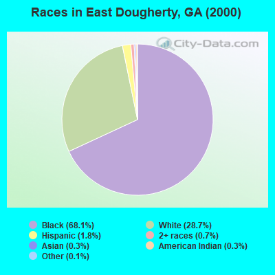
- 24,76568.1%Black alone
- 10,43228.7%White alone
- 6661.8%Hispanic
- 2580.7%Two or more races
- 920.3%American Indian alone
- 1200.3%Asian alone
- 380.1%Other race alone
- 140.04%Native Hawaiian and Other
Pacific Islander alone
Races in East Dougherty detailed stats: ancestries, foreign born residents, place of birth
 Recent articles from our blog. Our writers, many of them Ph.D. graduates or candidates, create easy-to-read articles on a wide variety of topics.

Current Local Time: EST time zone
Elevation: 260 feet
Land area: 112.6 square miles.
Population density: 321 people per square mile (very low).

| East Dougherty CCD: | 1.2% ($640) |
| Georgia: | 0.9% ($919) |
Nearest city with pop. 50,000+: Albany, GA  (3.9 miles , pop. 76,939).
Nearest city with pop. 200,000+: Montgomery, AL (139.1 miles , pop. 201,568).
Nearest city with pop. 1,000,000+: Houston, TX (682.2 miles , pop. 1,953,631).
Nearest cities:
), ), ), )Latitude: 31.56 N, Longitude: 84.10 W
Area code commonly used in this area: 229


| Here: | 3.7% |
| Georgia: | 2.9% |
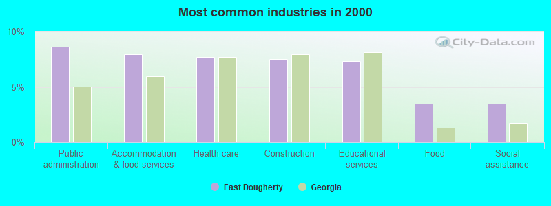
- Public administration (8.6%)
- Accommodation & food services (7.9%)
- Health care (7.7%)
- Construction (7.5%)
- Educational services (7.3%)
- Food (3.5%)
- Social assistance (3.5%)

- Construction (13.9%)
- Public administration (11.5%)
- Accommodation & food services (5.9%)
- Repair & maintenance (4.3%)
- Administrative & support & waste management services (4.2%)
- Truck transportation (4.0%)
- Paper (3.5%)
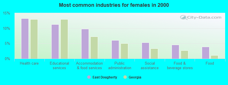
- Health care (13.2%)
- Educational services (11.3%)
- Accommodation & food services (9.8%)
- Public administration (6.0%)
- Social assistance (5.3%)
- Food & beverage stores (4.5%)
- Food (3.9%)
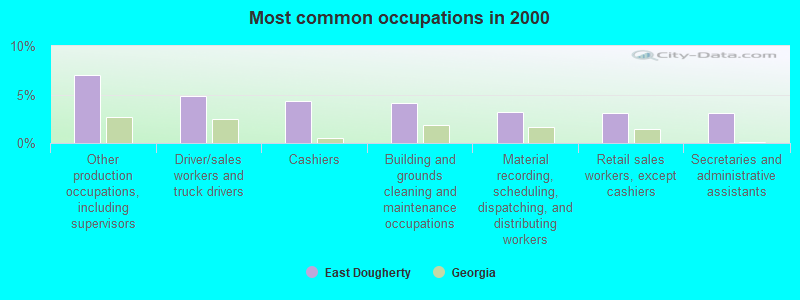
- Other production occupations, including supervisors (7.0%)
- Driver/sales workers and truck drivers (4.8%)
- Cashiers (4.3%)
- Building and grounds cleaning and maintenance occupations (4.2%)
- Material recording, scheduling, dispatching, and distributing workers (3.2%)
- Retail sales workers, except cashiers (3.1%)
- Secretaries and administrative assistants (3.1%)
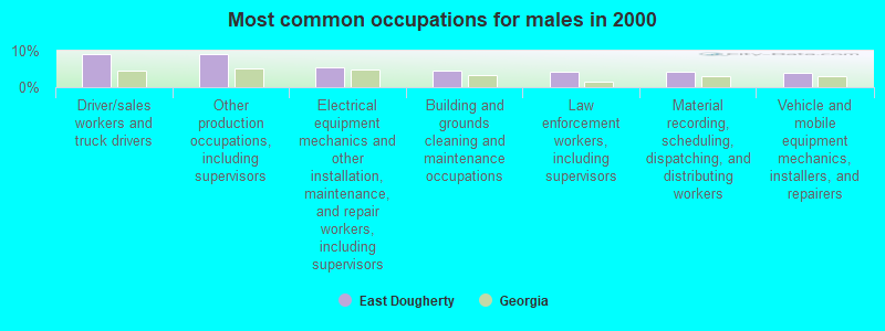
- Driver/sales workers and truck drivers (9.2%)
- Other production occupations, including supervisors (9.2%)
- Electrical equipment mechanics and other installation, maintenance, and repair workers, including supervisors (5.5%)
- Building and grounds cleaning and maintenance occupations (4.4%)
- Law enforcement workers, including supervisors (4.2%)
- Material recording, scheduling, dispatching, and distributing workers (4.2%)
- Vehicle and mobile equipment mechanics, installers, and repairers (4.1%)

- Cashiers (7.4%)
- Secretaries and administrative assistants (5.5%)
- Other production occupations, including supervisors (5.1%)
- Other office and administrative support workers, including supervisors (4.4%)
- Retail sales workers, except cashiers (4.0%)
- Preschool, kindergarten, elementary, and middle school teachers (4.0%)
- Building and grounds cleaning and maintenance occupations (3.9%)
Average climate in East Dougherty, Georgia
Based on data reported by over 4,000 weather stations


(lower is better)
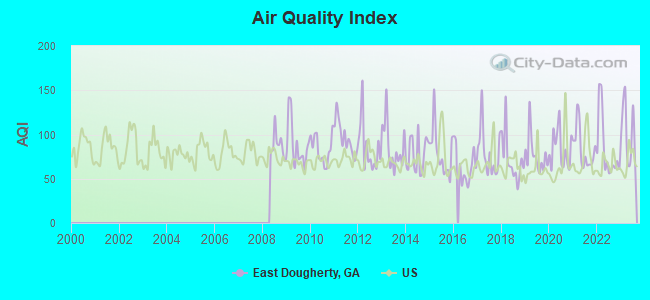
Air Quality Index (AQI) level in 2023 was 101. This is worse than average.
| City: | 101 |
| U.S.: | 73 |
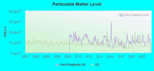
Particulate Matter (PM2.5) [µg/m3] level in 2023 was 12.4. This is significantly worse than average. Closest monitor was 1.0 miles away from the city center.
| City: | 12.4 |
| U.S.: | 8.1 |
Tornado activity:
East Dougherty-area historical tornado activity is slightly above Georgia state average. It is 47% greater than the overall U.S. average.
On 3/20/2003, a category F3 (max. wind speeds 158-206 mph) tornado 14.5 miles away from the East Dougherty place center killed 6 people and injured 200 people and caused $7 million in damages.
On 11/11/1968, a category F3 tornado 18.0 miles away from the place center caused between $5000 and $50,000 in damages.
Earthquake activity:
East Dougherty-area historical earthquake activity is significantly above Georgia state average. It is 11% smaller than the overall U.S. average.On 8/2/1974 at 08:52:09, a magnitude 4.9 (4.3 MB, 4.9 LG, Class: Light, Intensity: IV - V) earthquake occurred 185.3 miles away from the city center
On 10/24/1997 at 08:35:17, a magnitude 4.9 (4.8 MB, 4.2 MS, 4.9 LG, Depth: 6.2 mi) earthquake occurred 189.6 miles away from the city center
On 4/29/2003 at 08:59:39, a magnitude 4.9 (4.4 MB, 4.6 MW, 4.9 LG) earthquake occurred 221.2 miles away from East Dougherty center
On 1/18/1999 at 07:00:53, a magnitude 4.8 (4.8 MB, 4.0 LG, Depth: 0.6 mi) earthquake occurred 223.7 miles away from East Dougherty center
On 4/29/2003 at 08:59:39, a magnitude 4.6 (4.6 MW, Depth: 12.3 mi) earthquake occurred 221.2 miles away from the city center
On 11/22/1974 at 05:25:55, a magnitude 4.7 (4.7 MB) earthquake occurred 249.4 miles away from East Dougherty center
Magnitude types: regional Lg-wave magnitude (LG), body-wave magnitude (MB), surface-wave magnitude (MS), moment magnitude (MW)
Natural disasters:
The number of natural disasters in Dougherty County (11) is smaller than the US average (15).Major Disasters (Presidential) Declared: 8
Emergencies Declared: 1
Causes of natural disasters: Tornadoes: 6, Storms: 5, Floods: 4, Hurricanes: 2, Tropical Storms: 2, Winds: 2, Heavy Rain: 1, Other: 1 (Note: some incidents may be assigned to more than one category).
Hospitals and medical centers near East Dougherty:
- PHOEBE CARESOUTH HC ALBANY II (Home Health Center, about 1 miles away; ALBANY, GA)
- DCI EAST ALBANY (Dialysis Facility, about 3 miles away; ALBANY, GA)
- DCI ALBANY (Dialysis Facility, about 4 miles away; ALBANY, GA)
- INTREPID USA HEALTHCARE SERVICES (Home Health Center, about 5 miles away; ALBANY, GA)
- PALMYRA NH (Nursing Home, about 5 miles away; ALBANY, GA)
- PHOEBE NORTH (Hospital, about 5 miles away; ALBANY, GA)
- PHOEBE HOME CARE (Home Health Center, about 5 miles away; ALBANY, GA)
Colleges/universities with over 2000 students nearest to East Dougherty:
- Albany State University (about 3 miles; Albany, GA; Full-time enrollment: 3,662)
- Albany Technical College (about 5 miles; Albany, GA; FT enrollment: 3,707)
- Darton State College (about 7 miles; Albany, GA; FT enrollment: 5,000)
- Abraham Baldwin Agricultural College (about 35 miles; Tifton, GA; FT enrollment: 2,564)
- Georgia Southwestern State University (about 35 miles; Americus, GA; FT enrollment: 2,689)
- Bainbridge State College (about 53 miles; Bainbridge, GA; FT enrollment: 2,308)
- Wiregrass Georgia Technical College (about 65 miles; Valdosta, GA; FT enrollment: 3,246)
Points of interest:
Notable locations in East Dougherty: Radium Springs Country Club (A), Albany East Industrial Park (B), Northeast Industrial Park (C), Turner Field Municipal Golf Course (D), Albany Fire Department Station 3 (E), Albany Fire Department Station 9 (F), Talulah Massey Branch Library (G), Margaret Road Hazard Library (H), Albany Fire Department Station 07 (I). Display/hide their locations on the map
Shopping Centers: Junction Shopping Center (1), Oglethorpe Plaza Shopping Center (2), Radium Crossing Shopping Center (3), Shackleford Shopping Center (4). Display/hide their locations on the map
Churches in East Dougherty include: Williams Spring Church (A), Albany Church (B), Base Chapel (C), Wesley Chapel (D), Union Baptist Church (E), Victory Church (F), Trinity United Methodist Church (G), Radium Springs Baptist Church (H), Radium Church (I). Display/hide their locations on the map
Cemeteries: Antioch Cemetery (1), Hill Cemetery (2). Display/hide their locations on the map
Reservoir: Lake Worth (A). Display/hide its location on the map
Creeks: Dry Creek (A), Piney Woods Creek (B), Muckalee Creek (C). Display/hide their locations on the map
Parks in East Dougherty include: Tallulah Massey Park (1), Albany Railroad Depot Historic District (2), Piney Woods Park (3), Shackleford Park (4). Display/hide their locations on the map
| This place: | 2.7 people |
| Georgia: | 2.6 people |
| This place: | 68.8% |
| Whole state: | 68.5% |
| This place: | 7.8% |
| Whole state: | 5.9% |
Likely homosexual households (counted as self-reported same-sex unmarried-partner households)
- Lesbian couples: 0.4% of all households
- Gay men: 0.3% of all households
| This place: | 30.4% |
| Whole state: | 13.0% |
| This place: | 15.2% |
| Whole state: | 6.1% |
People in group quarters in East Dougherty in 2010:
- 1,520 people in college/university student housing
- 829 people in local jails and other municipal confinement facilities
- 784 people in workers' group living quarters and job corps centers
- 40 people in military barracks and dormitories (nondisciplinary)
- 14 people in other noninstitutional facilities
- 9 people in group homes intended for adults
People in group quarters in East Dougherty in 2000:
- 1,149 people in college dormitories (includes college quarters off campus)
- 866 people in local jails and other confinement facilities (including police lockups)
- 813 people in job corps and vocational training facilities
- 187 people in military barracks, etc.
- 117 people in agriculture workers' dormitories on farms
- 62 people in state prisons
- 10 people in homes for the mentally retarded
- 2 people in military transient quarters for temporary residents
For population 15 years and over in East Dougherty:
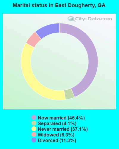
- Never married: 37.1%
- Now married: 45.4%
- Separated: 4.1%
- Widowed: 6.3%
- Divorced: 11.3%
For population 25 years and over in East Dougherty:
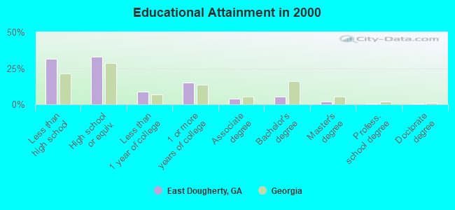
- High school or higher: 68.6%
- Bachelor's degree or higher: 8.2%
- Graduate or professional degree: 2.8%
- Unemployed: 13.4%
- Mean travel time to work (commute): 18.8 minutes
| Here: | 12.5 |
| Georgia average: | 13.3 |
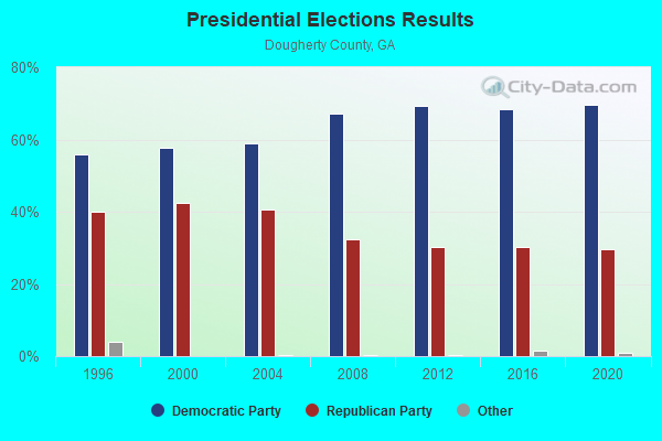
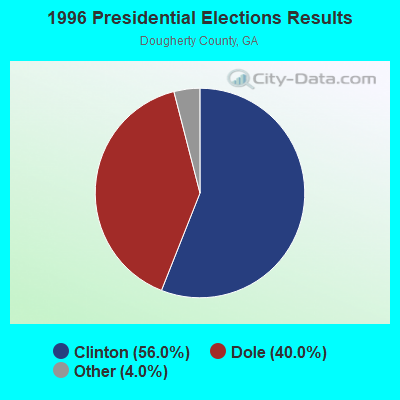
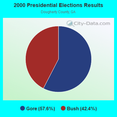
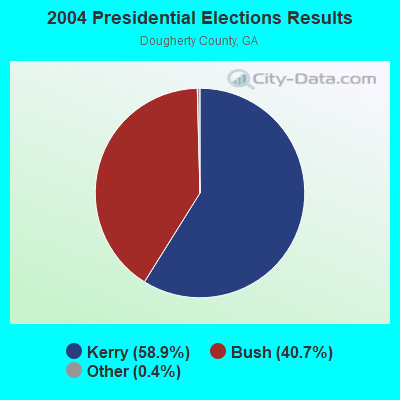
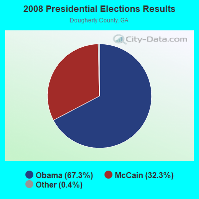
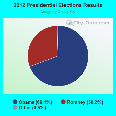
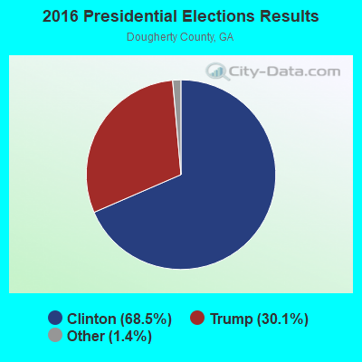
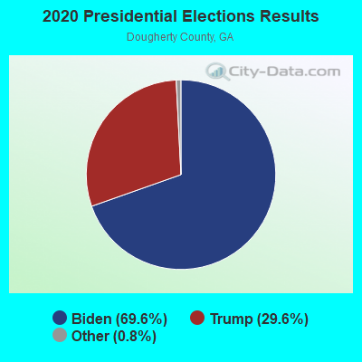
Graphs represent county-level data. Detailed 2008 Election Results
Religion statistics for East Dougherty, GA (based on Dougherty County data)
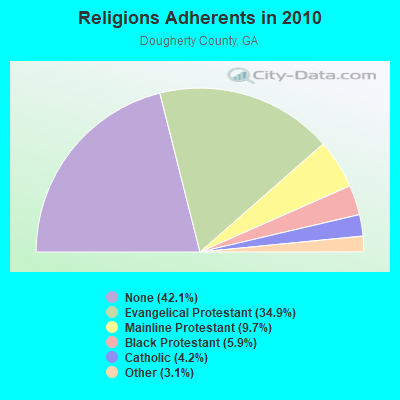
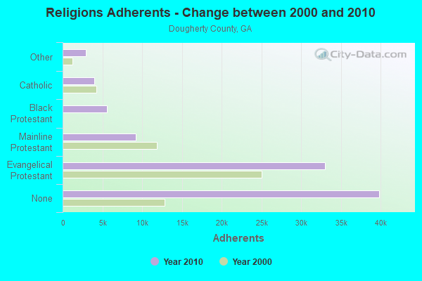
| Religion | Adherents | Congregations |
|---|---|---|
| Evangelical Protestant | 33,011 | 91 |
| Mainline Protestant | 9,196 | 17 |
| Black Protestant | 5,575 | 17 |
| Catholic | 3,963 | 1 |
| Other | 2,961 | 7 |
| Orthodox | 20 | 1 |
| None | 39,839 | - |
Food Environment Statistics:
| Dougherty County: | 2.30 / 10,000 pop. |
| Georgia: | 1.91 / 10,000 pop. |
| Dougherty County: | 0.21 / 10,000 pop. |
| Georgia: | 0.15 / 10,000 pop. |
| Dougherty County: | 1.05 / 10,000 pop. |
| Georgia: | 0.86 / 10,000 pop. |
| This county: | 7.32 / 10,000 pop. |
| Georgia: | 5.12 / 10,000 pop. |
| This county: | 7.11 / 10,000 pop. |
| Georgia: | 7.41 / 10,000 pop. |
| Dougherty County: | 14.1% |
| Georgia: | 10.4% |
| This county: | 31.1% |
| Georgia: | 27.8% |
| Dougherty County: | 15.7% |
| Georgia: | 14.6% |
Strongest AM radio stations in East Dougherty:
- WJYZ (960 AM; 5 kW; ALBANY, GA; Owner: CLEAR CHANNEL BROADCASTING LICENSES, INC.)
- WALG (1590 AM; 5 kW; ALBANY, GA; Owner: CUMULUS LICENSING CORP.)
- WSRA (1250 AM; 1 kW; ALBANY, GA; Owner: LIFELINE RADIO CORPORATION)
- WGPC (1450 AM; 1 kW; ALBANY, GA; Owner: CUMULUS LICENSING CORP.)
- WSTT (730 AM; 25 kW; THOMASVILLE, GA; Owner: MARION R. WILLIAMS)
- WMGA (1130 AM; 10 kW; MOULTRIE, GA; Owner: RADIO MOULTRIE, INC.)
- WMAC (940 AM; 50 kW; MACON, GA; Owner: CUMULUS LICENSING CORP.)
- WJEP (1020 AM; daytime; 10 kW; OCHLOCKNEE, GA; Owner: LIFELINE MINISTRIES, INCORPORATED)
- WHGH (840 AM; daytime; 10 kW; THOMASVILLE, GA; Owner: H. G. H INVESTMENT CORP.)
- WFVR (910 AM; 50 kW; VALDOSTA, GA; Owner: RAMA COMMUNICATIONS, INC.)
- WKTF (1550 AM; 10 kW; VIENNA, GA; Owner: SANTILLANA BROADCASTING, INC.)
- WMTM (1300 AM; 5 kW; MOULTRIE, GA; Owner: COLQUITT BROADCASTING COMPANY, LLC)
- WGST (640 AM; 50 kW; ATLANTA, GA; Owner: CITICASTERS LICENSES, L.P.)
Strongest FM radio stations in East Dougherty:
- WKAK (104.5 FM; ALBANY, GA; Owner: CUMULUS LICENSING CORP.)
- WNUQ (101.7 FM; ALBANY, GA; Owner: CUMULUS LICENSING CORP.)
- WJAD (103.5 FM; LEESBURG, GA; Owner: CUMULUS LICENSING CORP.)
- WJIZ-FM (96.3 FM; ALBANY, GA; Owner: CLEAR CHANNEL BROADCASTING LICENSES, INC.)
- W273AE (102.5 FM; ALBANY, GA; Owner: BIBLE BROADCASTING NETWORK, INC.)
- WUNV (91.7 FM; ALBANY, GA; Owner: GEORGIA PUBLIC TELECOMMUNICATIONS COMMISSION)
- WOBB (100.3 FM; TIFTON, GA; Owner: CLEAR CHANNEL BROADCASTING LICENSES, INC.)
- WBJY (89.3 FM; AMERICUS, GA; Owner: AMERICAN FAMILY ASSOCIATION)
- WRXZ (106.1 FM; SYLVESTER, GA; Owner: ON TOP COMMUNICATIONS OF GEORGIA, LLC)
- WRAK-FM (97.3 FM; BAINBRIDGE, GA; Owner: CLEAR CHANNEL BROADCASTING LICENSES, INC.)
- WZIQ (106.5 FM; SMITHVILLE, GA; Owner: BARINOWSKI INVESTMENT COMPANY)
- WAEF (90.3 FM; CORDELE, GA; Owner: AMERICAN FAMILY ASSOCIATION)
- WZBN (102.1 FM; SYLVESTER, GA; Owner: CUMULUS LICENSING CORP.)
- WWXC (90.7 FM; ALBANY, GA; Owner: LAMAD MINISTRIES, INC.)
- WEGC (107.7 FM; SASSER, GA; Owner: CUMULUS LICENSING CORP.)
- WMTM-FM (93.9 FM; MOULTRIE, GA; Owner: COLQUITT BROADCASTING COMPANY, LLC)
- WQVE (105.5 FM; CAMILLA, GA; Owner: CUMULUS LICENSING CORP.)
- W203AT (88.5 FM; ALBANY, GA; Owner: FAMILY STATIONS, INC.)
- WSRD-LP (93.1 FM; ALBANY, GA; Owner: SONSHINE RADIO CORPORATION)
TV broadcast stations around East Dougherty:
- W34CZ (Channel 34; ALBANY, GA; Owner: TRINITY BROADCASTING NETWORK)
- WBKL-LP (Channel 35; ALBANY, GA; Owner: GWENDOLYN BOONE)
- WALB (Channel 10; ALBANY, GA; Owner: LIBCO, INC.)
- WABW-TV (Channel 14; PELHAM, GA; Owner: GEORGIA PUBLIC TELECOMMUNICATIONS COMMISSION)
- WFXL (Channel 31; ALBANY, GA; Owner: WAITT LICENSE COMPANY OF GEORGIA, L.L.C.)
- WTLH (Channel 49; BAINBRIDGE, GA; Owner: WTLH LICENSE CORP.)
- WACS-TV (Channel 25; DAWSON, GA; Owner: GEORGIA PUBLIC TELECOMMUNICATIONS COMMISSION)
- WTWC-TV (Channel 40; TALLAHASSEE, FL; Owner: WTWC LICENSEE, LLC)
- WCTV (Channel 6; THOMASVILLE, GA; Owner: WCTV LICENSEE CORP.)
- W19CP (Channel 19; MOULTRIE, GA; Owner: TIFT AREA TV)
- WSST-TV (Channel 55; CORDELE, GA; Owner: SUNBELT-SOUTH TELECOMMUNICATIONS LTD)
FCC Registered Commercial Land Mobile Towers:
1- 0.37 Km S Of Spring Flats Rd 6.35 Km E Of Spring Flats Rd Co Line Rd Jct 6.1 Mi (Lat: 31.504333 Lon: -83.929333), Call Sign: KPM406, Licensee ID: L00279107,
Assigned Frequencies: 450.010 MHz, Grant Date: 03/09/1993, Expiration Date: 04/01/2012, Cancellation Date: 03/10/2010, Registrant: Educational Media Foundation, 5700 West Oaks Blvd., Rocklin, CA 95765, Phone: (912) 776-2040
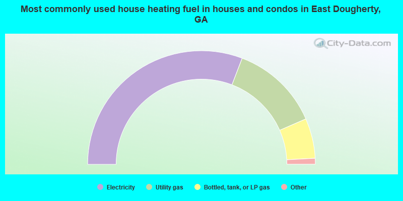
- 61.7%Electricity
- 25.3%Utility gas
- 11.4%Bottled, tank, or LP gas
- 0.9%Fuel oil, kerosene, etc.
- 0.4%Wood
- 0.2%Other fuel
- 0.2%No fuel used
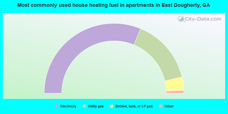
- 62.5%Electricity
- 30.1%Utility gas
- 6.3%Bottled, tank, or LP gas
- 0.7%No fuel used
- 0.3%Fuel oil, kerosene, etc.
- 0.2%Other fuel
East Dougherty compared to Georgia state average:
- Median household income below state average.
- Median house value significantly below state average.
- Black race population percentage above state average.
- Hispanic race population percentage significantly below state average.
- Median age significantly below state average.
- Foreign-born population percentage significantly below state average.
- Renting percentage above state average.
- Length of stay since moving in significantly above state average.
- Number of rooms per house significantly below state average.
- House age significantly below state average.
- Percentage of population with a bachelor's degree or higher significantly below state average.
East Dougherty on our top lists:
- #14 on the list of "Top 101 cities with largest percentage of males in industries: beverage and tobacco products (population 5,000+)"
- #18 on the list of "Top 101 cities with the smallest percentage of elementary and middle school students in private schools (5,000+ students)"
- #20 on the list of "Top 101 cities with largest percentage of females in occupations: life, physical, and social science technicians (population 5,000+)"
- #23 on the list of "Top 101 cities with largest percentage of females in industries: beverage and tobacco products (population 5,000+)"
- #24 on the list of "Top 101 cities with largest percentage of females in occupations: food processing workers (population 5,000+)"
- #28 on the list of "Top 101 cities with largest percentage of females in industries: paper (population 5,000+)"
- #29 on the list of "Top 101 cities with largest percentage of females in industries: food (population 5,000+)"
- #32 on the list of "Top 101 cities with the largest percentage of people in job corps and vocational training facilities (population 1,000+)"
- #39 on the list of "Top 101 cities with largest percentage of males in industries: alcoholic beverages merchant wholesalers (population 5,000+)"
- #41 on the list of "Top 101 cities with largest percentage of females in occupations: cashiers (population 5,000+)"
- #45 on the list of "Top 101 cities with largest percentage of males in industries: plastics and rubber products (population 5,000+)"
- #53 on the list of "Top 101 cities with largest percentage of males in occupations: driver/sales workers and truck drivers (population 5,000+)"
- #61 on the list of "Top 101 cities with largest percentage of males in industries: paper (population 5,000+)"
- #62 on the list of "Top 101 cities with largest percentage of males in industries: social assistance (population 5,000+)"
- #66 on the list of "Top 101 cities with largest percentage of females in occupations: plant and system operators (population 5,000+)"
- #70 on the list of "Top 101 cities with largest percentage of females in occupations: fishing and hunting, and forest and logging workers (population 5,000+)"
- #77 on the list of "Top 101 cities with largest percentage of males in industries: food (population 5,000+)"
- #82 on the list of "Top 101 cities with largest percentage of females in industries: motor vehicles, parts and supplies merchant wholesalers (population 5,000+)"
- #88 on the list of "Top 101 cities with largest percentage of females in industries: textile mills and textile products (population 5,000+)"
- #99 on the list of "Top 101 cities with the largest percentage of people in military transient quarters for temporary residents (population 1,000+)"
- #54 on the list of "Top 101 counties with highest percentage of residents voting for Obama (Democrat) in the 2012 Presidential Election (pop. 50,000+)"
- #88 on the list of "Top 101 counties with the highest Particulate Matter (PM2.5) Annual air pollution readings in 2012 (µg/m3)"
- #92 on the list of "Top 101 counties with the smallest number of people without health insurance coverage in 2000 (pop. 50,000+)"