Eli, Kentucky
Submit your own pictures of this place and show them to the world
- OSM Map
- General Map
- Google Map
- MSN Map

| Males: 1,598 | |
| Females: 1,555 |
| Median resident age: | 42.8 years |
| Kentucky median age: | 35.9 years |
Zip code: 42642
| Eli: | $47,919 |
| KY: | $59,341 |
Estimated per capita income in 2022: $27,844 (it was $14,038 in 2000)
Eli CCD income, earnings, and wages data
Estimated median house or condo value in 2022: $130,656 (it was $52,500 in 2000)
| Eli: | $130,656 |
| KY: | $196,300 |
Detailed information about poverty and poor residents in Eli, KY
Compare current foreclosures near Eli, KY:
| Photo | Address | Area | Beds / Baths | Price | Details |
|---|---|---|---|---|---|

|
#1
Main St
Russell Springs, KY 42642
|
1,258 sq. feet
|
1 baths 3 beds |
show details | |

|
#2
Lucky Leaf Dr
Somerset, KY 42503
|
1,776 sq. feet
|
2 baths 3 beds |
show details | |

|
#3
Allen Schoolhouse Rd
Columbia, KY 42728
|
936 sq. feet
|
1 baths 2 beds |
show details | |

|
#4
Wilson Ridge Rd
Science Hill, KY 42553
|
720 sq. feet
|
2 baths 5 beds |
show details | |

|
#5
Green Acres Dr
Monticello, KY 42633
|
2,212 sq. feet
|
2 baths 3 beds |
show details | |

|
#6
Hall Ridge Rd
Science Hill, KY 42553
|
1,568 sq. feet
|
2 baths 3 beds |
show details | |

|
#7
Meagan Ct
Monticello, KY 42633
|
978 sq. feet
|
1 baths 2 beds |
show details | |

|
#8
Green Acres Dr
Monticello, KY 42633
|
1,057 sq. feet
|
1 baths 3 beds |
show details | |

|
#9
W Highway 80
Somerset, KY 42503
|
1,824 sq. feet
|
2 baths 3 beds |
show details | |

|
#10
W Highway 92
Monticello, KY 42633
|
1,931 sq. feet
|
2 baths 3 beds |
show details |
| Photo | Address | Area | Beds / Baths | Price | Details |
|---|---|---|---|---|---|

|
#11
Heartland Dr
Somerset, KY 42503
|
1,661 sq. feet
|
1 baths 3 beds |
show details | |

|
#12
Adair St
Monticello, KY 42633
|
1,144 sq. feet
|
1 baths 3 beds |
show details | |

|
#13
Michigan Ave
Monticello, KY 42633
|
1,092 sq. feet
|
1 baths 4 beds |
show details | |

|
#14
Shepherd Dr
Russell Springs, KY 42642
|
1,440 sq. feet
|
1 baths 3 beds |
show details | |

|
#15
Lakeway Dr
Russell Springs, KY 42642
|
1,398 sq. feet
|
1 baths 3 beds |
show details | |

|
#16
Westgate Dr
Somerset, KY 42503
|
1,092 sq. feet
|
1 baths 3 beds |
show details | |

|
#17
Hollow Creek Dr
Somerset, KY 42503
|
2,077 sq. feet
|
3 baths 4 beds |
show details | |

|
#18
E Highway 1248
Somerset, KY 42503
|
972 sq. feet
|
1 baths 2 beds |
show details | |

|
#19
Lily Creek Resort Rd
Jamestown, KY 42629
|
1,900 sq. feet
|
2 baths 3 beds |
show details | |

|
#20
Ridgeview Dr
Somerset, KY 42503
|
1,608 sq. feet
|
1 baths 3 beds |
show details |
| Photo | Address | Area | Beds / Baths | Price | Details |
|---|---|---|---|---|---|

|
#21
Pine Tree Rd
Nancy, KY 42544
|
1,300 sq. feet
|
1 baths 3 beds |
show details | |

|
#22
Hearthside Dr
Somerset, KY 42503
|
1,536 sq. feet
|
2 baths 3 beds |
show details | |

|
#23
Jericho Rd
Russell Springs, KY 42642
|
- sq. feet
|
1 baths 3 beds |
show details | |

|
#24
Damron Creek Rd
Russell Springs, KY 42642
|
- sq. feet
|
1 baths 3 beds |
show details | |

|
#25
Womack St
Russell Springs, KY 42642
|
- sq. feet
|
1 baths 3 beds |
show details | |

|
#26
S Main St
Monticello, KY 42633
|
- sq. feet
|
- baths - beds |
show details | |

|
#27
Frisby St
Monticello, KY 42633
|
1,620 sq. feet
|
- baths - beds |
show details | |

|
#28
W Highway 90
Monticello, KY 42633
|
672 sq. feet
|
- baths - beds |
show details | |

|
#29
Spruce Pine Rd
Columbia, KY 42728
|
2,080 sq. feet
|
- baths - beds |
show details | |

|
#30
L Stringer Rd
Somerset, KY 42503
|
- sq. feet
|
- baths - beds |
show details |
| Photo | Address | Area | Beds / Baths | Price | Details |
|---|---|---|---|---|---|

|
#31
Pendleton Hollow Rd
Monticello, KY 42633
|
- sq. feet
|
- baths - beds |
show details | |

|
#32
Slate Branch Spur # 2
Somerset, KY 42503
|
- sq. feet
|
- baths - beds |
show details | |

|
#33
Strawberry Rd
Monticello, KY 42633
|
- sq. feet
|
- baths - beds |
show details | |

|
#34
Trails End
Somerset, KY 42503
|
- sq. feet
|
- baths - beds |
show details | |

|
#35
Highway 789
Monticello, KY 42633
|
- sq. feet
|
- baths - beds |
show details | |

|
#36
Hillside Ct
Somerset, KY 42503
|
- sq. feet
|
- baths - beds |
show details | |

|
#37
Ringgold Rd
Somerset, KY 42503
|
- sq. feet
|
- baths - beds |
show details | |

|
#38
Randalls Way
Somerset, KY 42503
|
- sq. feet
|
- baths - beds |
show details | |

|
#39
Henson Ridge Rd
Liberty, KY 42539
|
- sq. feet
|
- baths - beds |
show details | |

|
#40
Holly Hill Dr # A
Somerset, KY 42503
|
- sq. feet
|
- baths - beds |
show details |
| Photo | Address | Area | Beds / Baths | Price | Details |
|---|---|---|---|---|---|

|
#41
Meredith Rd
Monticello, KY 42633
|
- sq. feet
|
- baths - beds |
show details | |

|
#42
Highway 776
Monticello, KY 42633
|
- sq. feet
|
- baths - beds |
show details | |

|
#43
New Concord Rd
Columbia, KY 42728
|
- sq. feet
|
- baths - beds |
show details | |

|
#44
Highway 1546
Monticello, KY 42633
|
- sq. feet
|
- baths - beds |
show details | |

|
#45
Highway 235
Nancy, KY 42544
|
- sq. feet
|
- baths - beds |
show details | |

|
#46
Richardson Rd
Nancy, KY 42544
|
- sq. feet
|
- baths - beds |
show details | |

|
#47
N Highway 55
Jamestown, KY 42629
|
- sq. feet
|
- baths - beds |
show details | |

|
#48
Rescue Rd
Russell Springs, KY 42642
|
- sq. feet
|
- baths - beds |
show details | |

|
#49
Highway 196
Nancy, KY 42544
|
- sq. feet
|
- baths - beds |
show details | |

|
Check over 1 million property listings on Foreclosure.com!
|
browse all offers | |||

- 2,95798.0%White alone
- 270.9%Hispanic
- 130.4%Two or more races
- 90.3%Black alone
- 40.1%American Indian alone
- 40.1%Other race alone
- 10.03%Asian alone
- 10.03%Native Hawaiian and Other
Pacific Islander alone

Races in Eli detailed stats: ancestries, foreign born residents, place of birth
 Recent articles from our blog. Our writers, many of them Ph.D. graduates or candidates, create easy-to-read articles on a wide variety of topics.

Current Local Time: CST time zone
Land area: 72.0 square miles.
Population density: 44 people per square mile (very low).

| Eli CCD: | 0.7% ($343) |
| Kentucky: | 0.8% ($610) |
Nearest city with pop. 50,000+: Fayette, KY  (73.8 miles , pop. 260,512).
Nearest city with pop. 1,000,000+: Chicago, IL (363.7 miles , pop. 2,896,016).
Nearest cities:
), ), ), ), Latitude: 37.02 N, Longitude: 84.95 W


| Here: | 5.0% |
| Kentucky: | 3.8% |

- Health care (9.4%)
- Construction (9.1%)
- Apparel (7.7%)
- Educational services (7.6%)
- Agriculture, forestry, fishing & hunting (7.3%)
- Public administration (5.0%)
- Accommodation & food services (3.9%)

- Construction (16.0%)
- Agriculture, forestry, fishing & hunting (12.2%)
- Apparel (7.7%)
- Public administration (4.8%)
- Electrical equipment, appliances, components (4.5%)
- Transportation equipment (3.4%)
- Metal & metal products (3.4%)

- Health care (17.6%)
- Educational services (14.3%)
- Apparel (7.7%)
- Food & beverage stores (6.6%)
- Finance & insurance (5.9%)
- Administrative & support & waste management services (5.5%)
- Public administration (5.3%)

- Other production occupations, including supervisors (6.5%)
- Farmers and farm managers (6.2%)
- Building and grounds cleaning and maintenance occupations (5.0%)
- Retail sales workers, except cashiers (4.2%)
- Other sales and related occupations, including supervisors (4.1%)
- Textile, apparel, and furnishings workers (4.1%)
- Laborers and material movers, hand (3.9%)

- Farmers and farm managers (10.9%)
- Other production occupations, including supervisors (10.5%)
- Construction traders workers except carpenters, electricians, painters, plumbers, and construction laborers (5.7%)
- Building and grounds cleaning and maintenance occupations (5.4%)
- Laborers and material movers, hand (4.6%)
- Other material moving workers, except laborers (4.2%)
- Assemblers and fabricators (3.9%)

- Other sales and related occupations, including supervisors (9.4%)
- Retail sales workers, except cashiers (6.2%)
- Textile, apparel, and furnishings workers (6.2%)
- Nursing, psychiatric, and home health aides (4.8%)
- Preschool, kindergarten, elementary, and middle school teachers (4.6%)
- Building and grounds cleaning and maintenance occupations (4.5%)
- Information and record clerks, except customer service representatives (3.7%)
Average climate in Eli, Kentucky
Based on data reported by over 4,000 weather stations


(lower is better)

Air Quality Index (AQI) level in 2022 was 62.9. This is about average.
| City: | 62.9 |
| U.S.: | 72.6 |

Ozone [ppb] level in 2022 was 28.6. This is about average. Closest monitor was 19.2 miles away from the city center.
| City: | 28.6 |
| U.S.: | 33.3 |

Particulate Matter (PM2.5) [µg/m3] level in 2022 was 7.87. This is about average. Closest monitor was 19.2 miles away from the city center.
| City: | 7.87 |
| U.S.: | 8.11 |
Tornado activity:
Eli-area historical tornado activity is near Kentucky state average. It is 29% greater than the overall U.S. average.
On 4/27/1971, a category F4 (max. wind speeds 207-260 mph) tornado 7.2 miles away from the Eli place center killed 2 people and injured 72 people and caused between $500,000 and $5,000,000 in damages.
On 4/3/1974, a category F4 tornado 11.7 miles away from the place center killed 10 people and injured 113 people and caused between $5000 and $50,000 in damages.
Earthquake activity:
Eli-area historical earthquake activity is significantly above Kentucky state average. It is 105% greater than the overall U.S. average.On 7/27/1980 at 18:52:21, a magnitude 5.2 (5.1 MB, 4.7 MS, 5.0 UK, 5.2 UK, Class: Moderate, Intensity: VI - VII) earthquake occurred 98.5 miles away from the city center
On 4/18/2008 at 09:36:59, a magnitude 5.4 (5.1 MB, 4.8 MS, 5.4 MW, 5.2 MW) earthquake occurred 188.7 miles away from Eli center
On 4/18/2008 at 09:36:59, a magnitude 5.2 (5.2 MW, Depth: 8.9 mi) earthquake occurred 188.7 miles away from Eli center
On 11/30/1973 at 07:48:41, a magnitude 4.7 (4.7 MB, 4.6 ML, Class: Light, Intensity: IV - V) earthquake occurred 100.9 miles away from Eli center
On 6/18/2002 at 17:37:15, a magnitude 5.0 (4.3 MB, 4.6 MW, 5.0 LG) earthquake occurred 169.1 miles away from Eli center
On 9/7/1988 at 02:28:09, a magnitude 4.6 (4.5 MB, 4.6 LG) earthquake occurred 97.0 miles away from the city center
Magnitude types: regional Lg-wave magnitude (LG), body-wave magnitude (MB), local magnitude (ML), surface-wave magnitude (MS), moment magnitude (MW)
Natural disasters:
The number of natural disasters in Russell County (14) is near the US average (15).Major Disasters (Presidential) Declared: 10
Emergencies Declared: 2
Causes of natural disasters: Storms: 8, Floods: 6, Tornadoes: 5, Mudslides: 3, Winds: 2, Winter Storms: 2, Blizzard: 1, Freeze: 1, Hurricane: 1, Landslide: 1, Snow: 1, Snowfall: 1, Other: 1 (Note: some incidents may be assigned to more than one category).
Colleges/universities with over 2000 students nearest to Eli:
- Somerset Community College (about 19 miles; Somerset, KY; Full-time enrollment: 4,698)
- Lindsey Wilson College (about 21 miles; Columbia, KY; FT enrollment: 2,552)
- Campbellsville University (about 32 miles; Campbellsville, KY; FT enrollment: 2,948)
- University of the Cumberlands (about 48 miles; Williamsburg, KY; FT enrollment: 3,585)
- Eastern Kentucky University (about 61 miles; Richmond, KY; FT enrollment: 13,525)
- Tennessee Technological University (about 67 miles; Cookeville, TN; FT enrollment: 9,761)
- Elizabethtown Community and Technical College (about 69 miles; Elizabethtown, KY; FT enrollment: 3,762)
Points of interest:
Notable locations in Eli: Irvins Store (A), Eli Volunteer Fire Department (B). Display/hide their locations on the map
Churches in Eli include: Lake Valley Church (A), Mount Eden Church (B), Parks Ridge Church of God (C), Pine Grove Church (D), Pinetop Church (E), Pottershop Church (F), Union Church (G), Clear Fork Church (H), Square Oak Church (I). Display/hide their locations on the map
Cemeteries: Hatfield Cemetery (1), Coffey Cemetery (2), Coleman Cemetery (3), Military Cemetery (4), Eli Cemetery (5), Walters Cemetery (6), Whittle Cemetery (7). Display/hide their locations on the map
Streams, rivers, and creeks: Alligator Creek (A), Bob Branch (B), Wolf Creek (C), Cooper Creek (D), Clear Fork (E), Caney Fork (F), Caney Creek (G), McFarland Creek (H), Lick Creek (I). Display/hide their locations on the map
Park in Eli: Wolf Creek Recreation Area (1). Display/hide its location on the map
| This place: | 2.4 people |
| Kentucky: | 2.5 people |
| This place: | 71.7% |
| Whole state: | 66.9% |
| This place: | 5.1% |
| Whole state: | 6.4% |
Likely homosexual households (counted as self-reported same-sex unmarried-partner households)
- Lesbian couples: 0.2% of all households
- Gay men: 0.1% of all households
| This place: | 22.5% |
| Whole state: | 15.8% |
| This place: | 9.8% |
| Whole state: | 6.6% |
For population 15 years and over in Eli:

- Never married: 15.6%
- Now married: 67.2%
- Separated: 2.1%
- Widowed: 8.6%
- Divorced: 8.5%
For population 25 years and over in Eli:
- High school or higher: 63.4%
- Bachelor's degree or higher: 8.2%
- Graduate or professional degree: 4.6%
- Unemployed: 6.0%
- Mean travel time to work (commute): 26.0 minutes


| Here: | 16.0 |
| Kentucky average: | 13.8 |
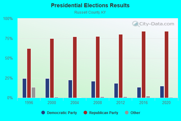
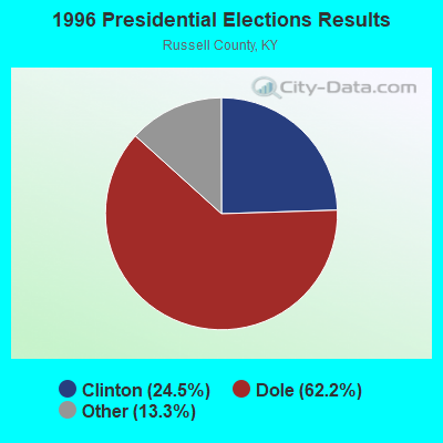
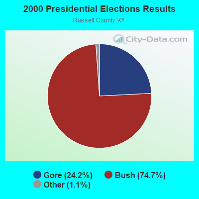
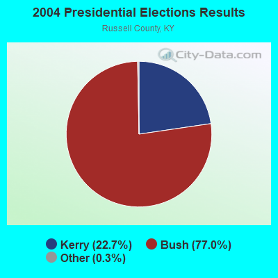
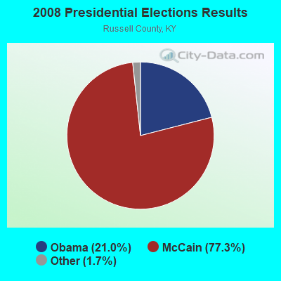
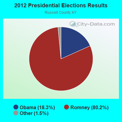

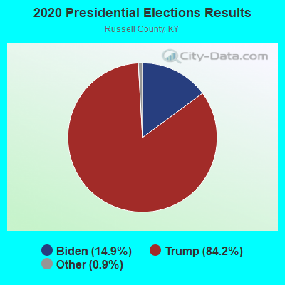
Graphs represent county-level data. Detailed 2008 Election Results
Religion statistics for Eli, KY (based on Russell County data)
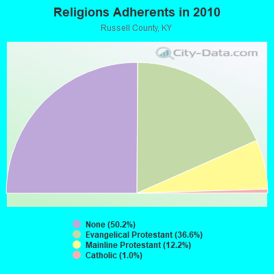
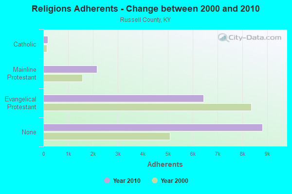
| Religion | Adherents | Congregations |
|---|---|---|
| Evangelical Protestant | 6,436 | 42 |
| Mainline Protestant | 2,148 | 11 |
| Catholic | 167 | 1 |
| Other | - | - |
| None | 8,814 | - |
Food Environment Statistics:
| Russell County: | 2.92 / 10,000 pop. |
| State: | 2.19 / 10,000 pop. |
| Russell County: | 1.17 / 10,000 pop. |
| Kentucky: | 0.74 / 10,000 pop. |
| Here: | 9.35 / 10,000 pop. |
| Kentucky: | 4.36 / 10,000 pop. |
| Here: | 8.76 / 10,000 pop. |
| State: | 5.74 / 10,000 pop. |
| This county: | 10.8% |
| Kentucky: | 11.0% |
| Russell County: | 31.6% |
| State: | 30.0% |
| Here: | 20.5% |
| Kentucky: | 15.9% |
Strongest AM radio stations in Eli:
- WJKY (1060 AM; daytime; 1 kW; JAMESTOWN, KY; Owner: LAKE CUMBERLAND BROADCASTERS)
- WIDS (570 AM; 0 kW; RUSSELL SPRINGS, KY; Owner: HAMMOND BROADCASTING, INC.)
- WKVL (850 AM; daytime; 50 kW; KNOXVILLE, TN; Owner: HORNE RADIO, LLC)
- WHAS (840 AM; 50 kW; LOUISVILLE, KY; Owner: CLEAR CHANNEL BROADCASTING LICENSES, INC.)
- WSM (650 AM; 50 kW; NASHVILLE, TN; Owner: GAYLORD ENTERTAINMENT COMPANY)
- WFLW (1360 AM; 1 kW; MONTICELLO, KY; Owner: STEPHEN W. STAPLES, JR.)
- WAMB (1160 AM; 50 kW; DONELSON, TN; Owner: GREAT SOUTHERN BROADCASTING COMPANY, INC.)
- WWAM (820 AM; daytime; 50 kW; JASPER, TN; Owner: SHELTON BROADCASTING SYSTEM)
- WKDA (1200 AM; 50 kW; NASHVILLE, TN; Owner: RADIO NASHVILLE, INC.)
- WLAC (1510 AM; 50 kW; NASHVILLE, TN; Owner: CAPSTAR TX LIMITED PARTNERSHIP)
- WEKC (710 AM; daytime; 4 kW; WILLIAMSBURG, KY; Owner: GERALD PARKS)
- WNQM (1300 AM; 50 kW; NASHVILLE, TN; Owner: WNQM. INC.)
- WLW (700 AM; 50 kW; CINCINNATI, OH; Owner: JACOR BROADCASTING CORPORATION)
Strongest FM radio stations in Eli:
- WJRS (104.9 FM; JAMESTOWN, KY; Owner: LAKE CUMBERLAND BROADCASTERS)
- WMKZ (93.1 FM; MONTICELLO, KY; Owner: MONTICELLO-WAYNE COUNTY MEDIA, INC.)
- WKYM (101.7 FM; MONTICELLO, KY; Owner: STEPHEN W. STAPLES JR.)
- WDCL-FM (89.7 FM; SOMERSET, KY; Owner: WESTERN KENTUCKY UNIVERSITY)
- WHVE (92.7 FM; RUSSELL SPRINGS, KY; Owner: SHORELINE COMMUNICATIONS, INC)
- WSEK (97.1 FM; SOMERSET, KY; Owner: CAPSTAR TX LIMITED PARTNERSHIP)
- WTHL (90.5 FM; SOMERSET, KY; Owner: SOMERSET EDUCATIONAL BROADCASTING FOUNDATION)
- WKII-FM (102.3 FM; SOMERSET, KY; Owner: CAPSTAR TX LIMITED PARTNERSHIP)
- WXKY-FM (96.3 FM; STANFORD, KY; Owner: LINCOLN-GARRARD BROADCASTING CO.,INC)
- WLLK (93.9 FM; BURNSIDE, KY; Owner: CAPSTAR TX LIMITED PARTNERSHIP)
- W277AA (103.3 FM; SOMERSET, KY; Owner: WESTERN KENTUCKY UNIVERSITY)
- WKDO-FM (98.7 FM; LIBERTY, KY; Owner: CARLOS D. WESLEY)
TV broadcast stations around Eli:
- WKSO-TV (Channel 29; SOMERSET, KY; Owner: KENTUCKY AUTHORITY FOR EDUCATIONAL TV)
- WBKI-TV (Channel 34; CAMPBELLSVILLE, KY; Owner: LOUISVILLE COMMUNICATIONS, LLC)

- 64.0%Electricity
- 13.8%Fuel oil, kerosene, etc.
- 10.3%Bottled, tank, or LP gas
- 9.0%Wood
- 1.5%No fuel used
- 1.3%Utility gas

- 51.2%Electricity
- 34.8%Fuel oil, kerosene, etc.
- 6.1%Bottled, tank, or LP gas
- 4.3%Utility gas
- 3.7%Wood
Eli compared to Kentucky state average:
- Median house value below state average.
- Unemployed percentage below state average.
- Black race population percentage significantly below state average.
- Hispanic race population percentage significantly below state average.
- Foreign-born population percentage significantly below state average.
- Renting percentage below state average.
- Length of stay since moving in significantly above state average.
- Number of rooms per house significantly below state average.
- House age significantly below state average.
- Number of college students below state average.
- Percentage of population with a bachelor's degree or higher significantly below state average.