Hiles, Wisconsin
Submit your own pictures of this town and show them to the world
- OSM Map
- General Map
- Google Map
- MSN Map
Population change since 2000: -23.0%
| Males: 164 | |
| Females: 147 |
| Median resident age: | 59.9 years |
| Wisconsin median age: | 42.6 years |
Zip codes: 54511.
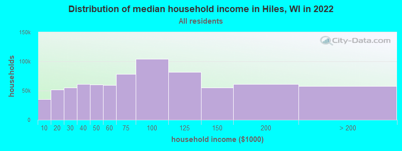
| Hiles: | $45,564 |
| WI: | $70,996 |
Estimated per capita income in 2022: $32,898 (it was $17,830 in 2000)
Hiles town income, earnings, and wages data
Estimated median house or condo value in 2022: $217,773 (it was $95,000 in 2000)
| Hiles: | $217,773 |
| WI: | $252,800 |
Detailed information about poverty and poor residents in Hiles, WI
Compare current foreclosures near Hiles, WI:
| Photo | Address | Area | Beds / Baths | Price | Details |
|---|---|---|---|---|---|

|
#1
Cypress St
Argonne, WI 54511
|
- sq. feet
|
- baths - beds |
$24,900
|
show details |

|
#2
Kotarski St
Three Lakes, WI 54562
|
- sq. feet
|
- baths - beds |
show details | |

|
#3
N 1st St
Eagle River, WI 54521
|
- sq. feet
|
- baths - beds |
show details | |

|
#4
Jonathan St Apt G
Eagle River, WI 54521
|
- sq. feet
|
- baths - beds |
show details | |

|
#5
Cypress St
Argonne, WI 54511
|
- sq. feet
|
- baths - beds |
show details | |

|
#6
Scattering Rice Lake Rd
Eagle River, WI 54521
|
- sq. feet
|
- baths - beds |
show details | |

|
#7
S 4th St
Eagle River, WI 54521
|
- sq. feet
|
- baths - beds |
show details | |

|
#8
Watersmeet Lake Rd
Eagle River, WI 54521
|
- sq. feet
|
- baths - beds |
show details | |

|
Check over 1 million property listings on Foreclosure.com!
|
browse all offers | |||

- 29795.5%White alone
- 61.9%Two or more races
- 41.3%Hispanic
- 31.0%American Indian alone
- 10.3%Native Hawaiian and Other
Pacific Islander alone
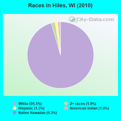
Races in Hiles detailed stats: ancestries, foreign born residents, place of birth
According to our research of Wisconsin and other state lists, there were 2 registered sex offenders living in Hiles, Wisconsin as of May 14, 2024.
The ratio of all residents to sex offenders in Hiles is 156 to 1.
 Recent articles from our blog. Our writers, many of them Ph.D. graduates or candidates, create easy-to-read articles on a wide variety of topics.


Latest news from Hiles, WI collected exclusively by city-data.com from local newspapers, TV, and radio stations
Ancestries: German (45.0%), Polish (8.2%), Norwegian (7.2%), English (6.2%), Irish (5.9%), French (5.0%).
Current Local Time: CST time zone
Elevation: 1670 feet
Land area: 131.4 square miles.
Population density: 2.4 people per square mile (very low).
2 residents are foreign born
| This town: | 0.5% |
| Wisconsin: | 3.6% |
| Hiles town: | 1.4% ($1,367) |
| Wisconsin: | 2.0% ($2,245) |
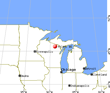
Nearest city with pop. 50,000+: Green Bay, WI  (102.3 miles , pop. 102,313).
Nearest city with pop. 200,000+: Madison, WI (191.1 miles , pop. 208,054).
Nearest city with pop. 1,000,000+: Chicago, IL (283.1 miles , pop. 2,896,016).
Nearest cities:
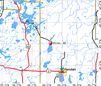
), ), Latitude: 45.82 N, Longitude: 88.99 W
Area code commonly used in this area: 715

| Here: | 4.2% |
| Wisconsin: | 2.7% |
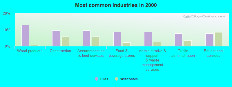
- Wood products (13.0%)
- Construction (9.6%)
- Accommodation & food services (9.6%)
- Food & beverage stores (8.7%)
- Administrative & support & waste management services (8.7%)
- Public administration (7.8%)
- Educational services (7.8%)
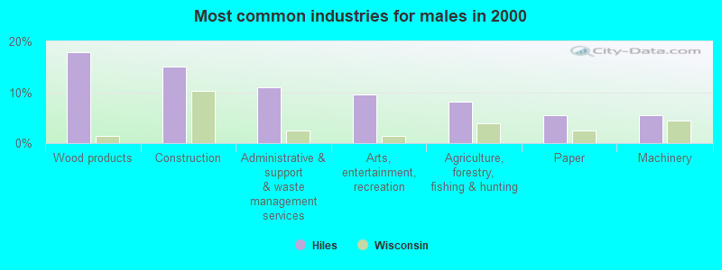
- Wood products (17.8%)
- Construction (15.1%)
- Administrative & support & waste management services (11.0%)
- Arts, entertainment, recreation (9.6%)
- Agriculture, forestry, fishing & hunting (8.2%)
- Paper (5.5%)
- Machinery (5.5%)
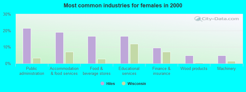
- Public administration (21.4%)
- Accommodation & food services (19.0%)
- Food & beverage stores (16.7%)
- Educational services (16.7%)
- Finance & insurance (9.5%)
- Wood products (4.8%)
- Machinery (4.8%)
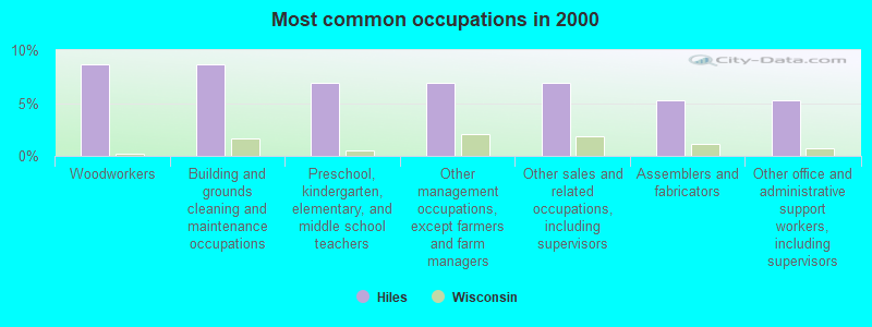
- Woodworkers (8.7%)
- Building and grounds cleaning and maintenance occupations (8.7%)
- Preschool, kindergarten, elementary, and middle school teachers (7.0%)
- Other management occupations, except farmers and farm managers (7.0%)
- Other sales and related occupations, including supervisors (7.0%)
- Assemblers and fabricators (5.2%)
- Other office and administrative support workers, including supervisors (5.2%)
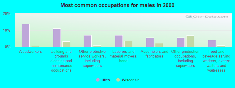
- Woodworkers (13.7%)
- Building and grounds cleaning and maintenance occupations (11.0%)
- Other protective service workers, including supervisors (6.8%)
- Laborers and material movers, hand (6.8%)
- Assemblers and fabricators (5.5%)
- Other production occupations, including supervisors (5.5%)
- Food and beverage serving workers, except waiters and waitresses (4.1%)
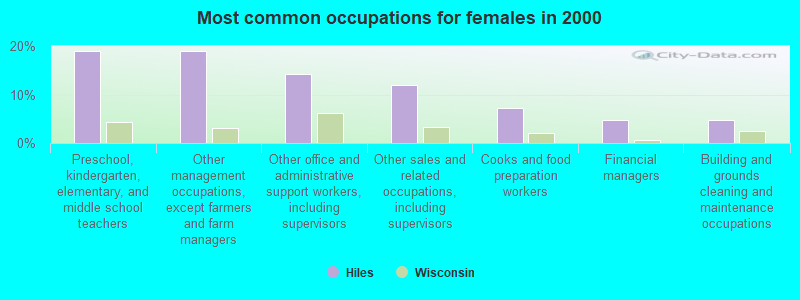
- Preschool, kindergarten, elementary, and middle school teachers (19.0%)
- Other management occupations, except farmers and farm managers (19.0%)
- Other office and administrative support workers, including supervisors (14.3%)
- Other sales and related occupations, including supervisors (11.9%)
- Cooks and food preparation workers (7.1%)
- Financial managers (4.8%)
- Building and grounds cleaning and maintenance occupations (4.8%)
Average climate in Hiles, Wisconsin
Based on data reported by over 4,000 weather stations


(lower is better)
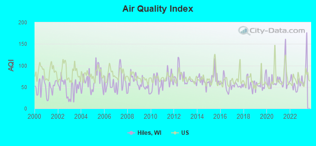
Air Quality Index (AQI) level in 2022 was 55.7. This is better than average.
| City: | 55.7 |
| U.S.: | 72.6 |
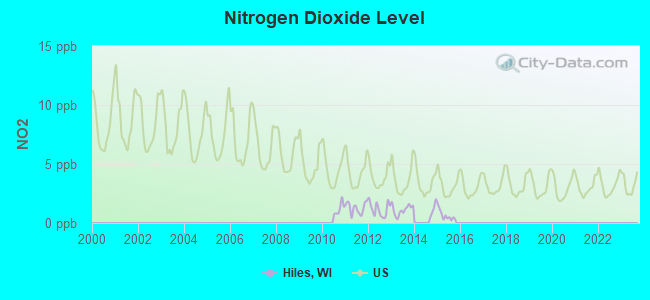
Nitrogen Dioxide (NO2) [ppb] level in 2015 was 0.642. This is significantly better than average. Closest monitor was 19.9 miles away from the city center.
| City: | 0.642 |
| U.S.: | 5.109 |
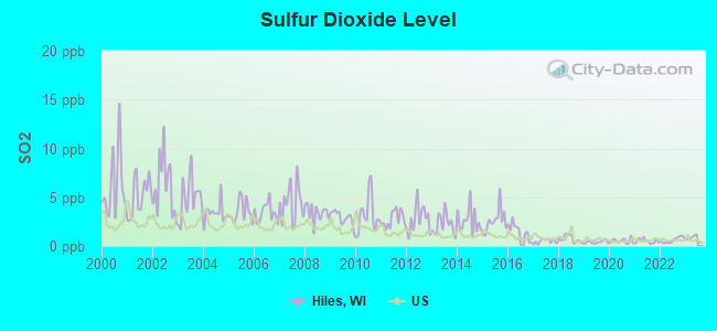
Sulfur Dioxide (SO2) [ppb] level in 2022 was 0.610. This is significantly better than average. Closest monitor was 19.9 miles away from the city center.
| City: | 0.610 |
| U.S.: | 1.515 |
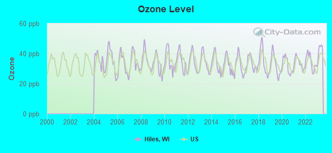
Ozone [ppb] level in 2022 was 34.5. This is about average. Closest monitor was 19.9 miles away from the city center.
| City: | 34.5 |
| U.S.: | 33.3 |
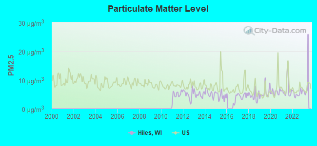
Particulate Matter (PM2.5) [µg/m3] level in 2022 was 5.26. This is significantly better than average. Closest monitor was 19.9 miles away from the city center.
| City: | 5.26 |
| U.S.: | 8.11 |
Tornado activity:
Hiles-area historical tornado activity is significantly below Wisconsin state average. It is 54% smaller than the overall U.S. average.
On 6/25/1950, a category F4 (max. wind speeds 207-260 mph) tornado 19.5 miles away from the Hiles town center killed 2 people and injured 12 people and caused between $50,000 and $500,000 in damages.
On 6/8/1985, a category F3 (max. wind speeds 158-206 mph) tornado 18.2 miles away from the town center killed 2 people and injured 42 people and caused between $5,000,000 and $50,000,000 in damages.
Earthquake activity:
Hiles-area historical earthquake activity is significantly above Wisconsin state average. It is 80% smaller than the overall U.S. average.On 7/9/1975 at 14:54:15, a magnitude 4.6 (4.6 MB, Class: Light, Intensity: IV - V) earthquake occurred 340.3 miles away from Hiles center
On 6/28/2004 at 06:10:52, a magnitude 4.2 (4.2 MW, Depth: 6.2 mi) earthquake occurred 301.8 miles away from Hiles center
On 5/2/2015 at 16:23:07, a magnitude 4.2 (4.2 MW, Depth: 2.8 mi) earthquake occurred 304.8 miles away from Hiles center
On 2/10/2010 at 09:59:35, a magnitude 3.8 (3.8 MW, Depth: 6.2 mi, Class: Light, Intensity: II - III) earthquake occurred 267.7 miles away from Hiles center
On 3/2/2017 at 16:53:31, a magnitude 3.2 (3.2 ML) earthquake occurred 188.2 miles away from the city center
On 2/7/2020 at 18:30:28, a magnitude 3.3 (3.3 ML) earthquake occurred 211.0 miles away from Hiles center
Magnitude types: body-wave magnitude (MB), local magnitude (ML), moment magnitude (MW)
Natural disasters:
The number of natural disasters in Forest County (6) is a lot smaller than the US average (15).Major Disasters (Presidential) Declared: 2
Emergencies Declared: 3
Causes of natural disasters: Floods: 2, Storms: 2, Tornadoes: 2, Winds: 2, Drought: 1, Hurricane: 1, Other: 1 (Note: some incidents may be assigned to more than one category).

Colleges/universities with over 2000 students nearest to Hiles:
- Northcentral Technical College (about 67 miles; Wausau, WI; Full-time enrollment: 3,356)
- Northern Michigan University (about 92 miles; Marquette, MI; FT enrollment: 8,258)
- Michigan Technological University (about 93 miles; Houghton, MI; FT enrollment: 6,078)
- University of Wisconsin-Stevens Point (about 94 miles; Stevens Point, WI; FT enrollment: 9,089)
- Northeast Wisconsin Technical College (about 100 miles; Green Bay, WI; FT enrollment: 6,069)
- University of Wisconsin-Green Bay (about 104 miles; Green Bay, WI; FT enrollment: 5,415)
- Saint Norbert College (about 106 miles; De Pere, WI; FT enrollment: 2,324)
Points of interest:
Notable locations in Hiles: Luna-White Deer Campground (A), Griswolds Camp (B), Sevenmile Lake Campground (C), Pine Lake Campground (D), Headwaters of Wolf River Point of Interest (E), Franklin Lake Campground (F), Giant Pine Ski and Hike Parking Lot (G), Camp White Deer (H), Giant Pine Grove Point of Interest (I), Eastern Continental Divide Point of Interest (J), Scott-Shelp Lake Hemlock Grove Point of Interest (K), Kimball Creek Snowmobile Parking Lot (L), Franklin Lake Campground (M), Hiles Volunteer Fire Department Station A (N), Hiles Volunteer Fire Department Station B (O). Display/hide their locations on the map
Cemetery: Hiles Cemetery (1). Display/hide its location on the map
Lakes and reservoirs: Pat Shay Lake (A), Pine Lake (B), Quartz Lake (C), Robbins Lake (D), Scott Lake (E), Shelp Lake (F), Sunfish Lake (G), Three Johns Lake (H). Display/hide their locations on the map
Creeks: Wildcat Creek (A), Howell Creek (B), Sucker Creek (C), Furbush Creek (D), Copper Creek (E), Pine Creek (F). Display/hide their locations on the map
Parks in Hiles include: Bose Lake Hemlock-Hardwoods State Natural Area (1), Giant White Pine Grove State Natural Area (2), Scott Lake-Shelp Lake State Natural Area (3), Argonne Experimental Forest (4). Display/hide their locations on the map
Drinking water stations with addresses in Hiles that have no violations reported:
- PINE LAKE PUB AND CAFE (Population served: 35, Primary Water Source Type: Groundwater)
- STRANDS SUNSET RESORT (Population served: 25, Primary Water Source Type: Groundwater)
| This town: | 2.0 people |
| Wisconsin: | 2.4 people |
| This town: | 63.1% |
| Whole state: | 64.4% |
| This town: | 4.5% |
| Whole state: | 7.3% |
Likely homosexual households (counted as self-reported same-sex unmarried-partner households)
- Lesbian couples: 0.0% of all households
- Gay men: 0.6% of all households
| This town: | 11.9% |
| Whole state: | 8.7% |
| This town: | 9.3% |
| Whole state: | 3.7% |
For population 15 years and over in Hiles:
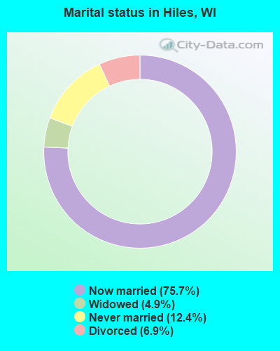
- Never married: 12.4%
- Now married: 75.7%
- Separated: 0.0%
- Widowed: 4.9%
- Divorced: 6.9%
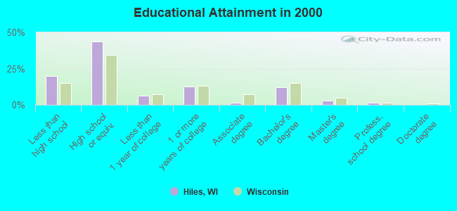
For population 25 years and over in Hiles:
- High school or higher: 80.2%
- Bachelor's degree or higher: 16.5%
- Graduate or professional degree: 4.3%
- Unemployed: 5.7%
- Mean travel time to work (commute): 38.2 minutes
| Here: | 9.7 |
| Wisconsin average: | 11.0 |
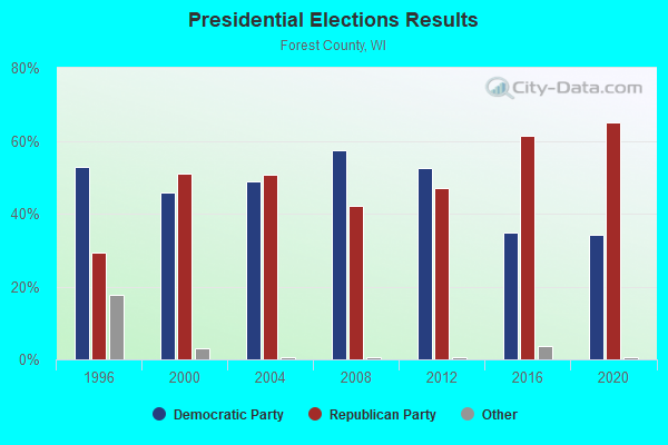
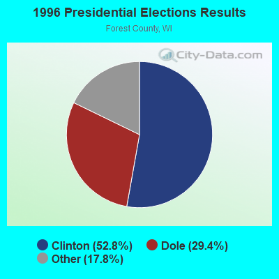
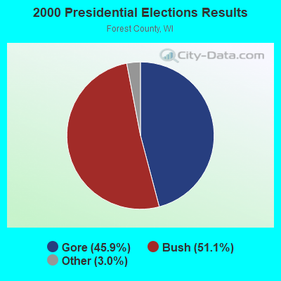
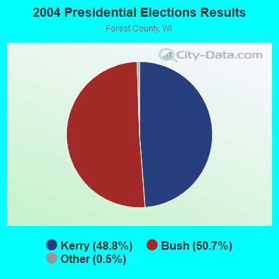
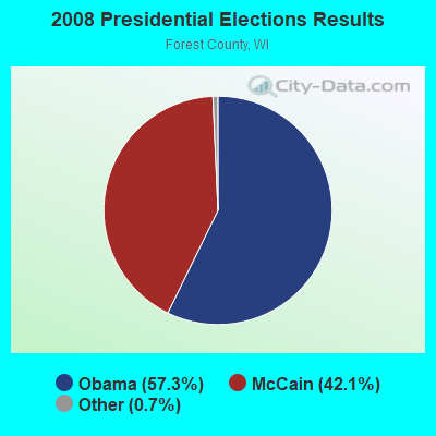
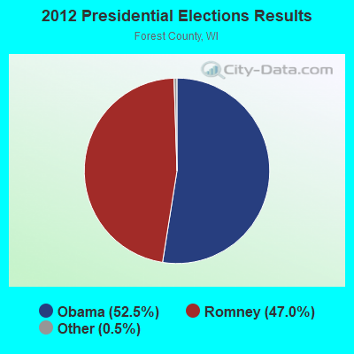
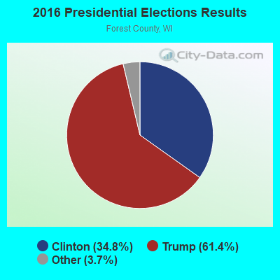
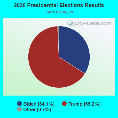
Graphs represent county-level data. Detailed 2008 Election Results
Religion statistics for Hiles, WI (based on Forest County data)
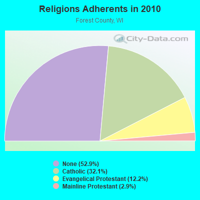
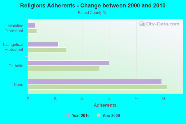
| Religion | Adherents | Congregations |
|---|---|---|
| Catholic | 2,984 | 5 |
| Evangelical Protestant | 1,132 | 11 |
| Mainline Protestant | 266 | 4 |
| Other | 2 | 3 |
| None | 4,920 | - |
Food Environment Statistics:
| Here: | 2.04 / 10,000 pop. |
| Wisconsin: | 1.86 / 10,000 pop. |
| Forest County: | 6.13 / 10,000 pop. |
| Wisconsin: | 4.12 / 10,000 pop. |
| This county: | 14.30 / 10,000 pop. |
| Wisconsin: | 8.64 / 10,000 pop. |
| Forest County: | 9.9% |
| State: | 7.6% |
| Forest County: | 28.5% |
| Wisconsin: | 27.5% |
| Forest County: | 19.3% |
| State: | 13.0% |
Strongest AM radio stations in Hiles:
- WSAU (550 AM; 20 kW; WAUSAU, WI; Owner: WRIG, INC.)
- WSPT (1010 AM; 50 kW; STEVENS POINT, WI)
- WERL (950 AM; 1 kW; EAGLE RIVER, WI)
- WEBC (560 AM; 50 kW; DULUTH, MN)
- WNAM (1280 AM; 50 kW; NEENAH-MENASHA, WI; Owner: CUMULUS LICENSING CORP.)
- WLKD (1570 AM; 5 kW; MINOCQUA, WI; Owner: RAVEN BROADCASTING CORPORATION)
- WTCM (580 AM; 35 kW; TRAVERSE CITY, MI; Owner: WTCM RADIO, INC.)
- WDBC (680 AM; 10 kW; ESCANABA, MI; Owner: KMB BROADCASTING, INC.)
- WOBT (1240 AM; 1 kW; RHINELANDER, WI; Owner: NEWRADIO GROUP, LLC)
- WTMJ (620 AM; 50 kW; MILWAUKEE, WI; Owner: JOURNAL BROADCAST CORPORATION)
- WJMS (590 AM; 5 kW; IRONWOOD, MI; Owner: ROBERTS BROADCASTING, INC.)
- WHBY (1150 AM; 25 kW; KIMBERLY, WI; Owner: WOODWARD COMMUNICATIONS, INC.)
- WIKB (1230 AM; 1 kW; IRON RIVER, MI; Owner: NORTHLAND ADVERTISING, INC.)
Strongest FM radio stations in Hiles:
- WXPR (91.7 FM; RHINELANDER, WI; Owner: WHITE PINE COMMUNITY B/CASTING, INC.)
- WLSL (93.7 FM; THREE LAKES, WI; Owner: RESULTS BROADCASTING OF RHINELANDER, INC.)
- WRLO-FM (105.3 FM; ANTIGO, WI; Owner: NEWRADIO GROUP, LLC)
- WHDG (97.5 FM; RHINELANDER, WI; Owner: RAVEN BROADCASTING CORPORATION)
- WIKB-FM (99.1 FM; IRON RIVER, MI; Owner: NORTHLAND ADVERTISING, INC.)
- WRJO (94.5 FM; EAGLE RIVER, WI; Owner: BERNER BROADCASTING, INC.)
- WRHN (100.1 FM; RHINELANDER, WI; Owner: NEWRADIO GROUP, LLC)
TV broadcast stations around Hiles:
- WYOW (Channel 34; EAGLE RIVER, WI; Owner: WAOW-WYOW TELEVISION, INC.)
- WJFW-TV (Channel 12; RHINELANDER, WI; Owner: NORTHLAND TELEVISION, INC.)
- WBIJ (Channel 4; CRANDON, WI; Owner: SELENKA COMMUNICATIONS, LLC)
- WTPX (Channel 46; ANTIGO, WI; Owner: PAXSON WAUSAU LICENSE, INC.)
- W04CS (Channel 4; CRANDON, WI; Owner: THREE ANGELS BROADCASTING NETWORK)
- W54AR (Channel 54; FENCE, WI; Owner: STATE OF WISCONSIN - EDUCATIONAL COMMUNICATIONS BOARD)
- W57AR (Channel 57; SAYNER/VILAS COUNTY, WI; Owner: GRAY MIDAMERICA TV LICENSEE CORP.)
FCC Registered Antenna Towers:
3- Tyler Garry, 8285 Hwy S (Lat: 45.673111 Lon: -88.945889), Type: 91.4, Structure height: 55041 m, Overall height: 91.4 m, Registrant: Northwoods Communication Technologies, Tyler@northwoodsconnect.Com, , Rhine-lander, Phone: (715) 544-8025
- Tyler P Garry, 8285 Hwy S (Lat: 45.673111 Lon: -88.945889), Type: 91.4, Structure height: 55041 m, Overall height: 91.4 m, Registrant: Northwoods Communication Technologies, Tyler@northwoodsconnect.Com, , Rhine-lander, Phone: (715) 544-8025
- Tyler P Garry, 8285 Hwy S (Lat: 45.673111 Lon: -88.945889), Type: 91.4, Structure height: 55041 m, Overall height: 91.4 m, Registrant: Northwoods Communication Technologies, Tyler@northwoodsconnect.Com, , Rhine-lander, Phone: (715) 544-8025
FCC Registered Broadcast Land Mobile Towers:
1- 15065 Crossover Rd. (Lat: 45.912889 Lon: -89.012111), Type: Gtower, Structure height: 30 m, Overall height: 36 m, Call Sign: KNGB665,
Assigned Frequencies: 155.895 MHz, Grant Date: 04/10/2021, Expiration Date: 05/03/2031, Certifier: Roger W Wilson, Registrant: Northway Communications Inc, 105 E Oak St, Wausau, WI 54401, Phone: (715) 848-1413, Fax: (715) 848-1413, Email:
FCC Registered Microwave Towers:
1- HILES SITE, 8285 Hwy S (Lat: 45.673111 Lon: -88.945889), Type: Gtower, Structure height: 91.4 m, Call Sign: WRLC867,
Assigned Frequencies: 11565.0 MHz, 11565.0 MHz, 11565.0 MHz, 11565.0 MHz, Grant Date: 03/11/2021, Expiration Date: 03/11/2031, Certifier: Matthew Osterman, Registrant: Marashlian & Donahue Pllc, 1430 Spring Hill Road, Mclean, VA 22102, Phone: (703) 714-1305, Email:
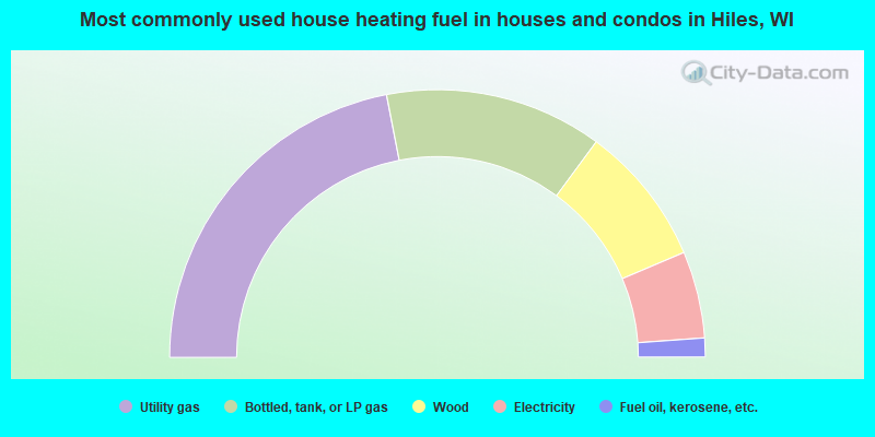
- 43.9%Utility gas
- 26.3%Bottled, tank, or LP gas
- 17.0%Wood
- 10.5%Electricity
- 2.3%Fuel oil, kerosene, etc.
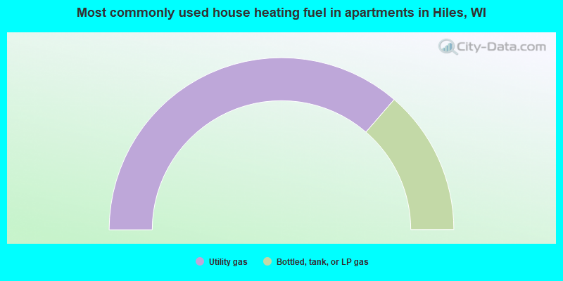
- 72.7%Utility gas
- 27.3%Bottled, tank, or LP gas
Hiles compared to Wisconsin state average:
- Median household income below state average.
- Unemployed percentage below state average.
- Black race population percentage significantly below state average.
- Hispanic race population percentage significantly below state average.
- Median age significantly above state average.
- Foreign-born population percentage significantly below state average.
- Renting percentage significantly below state average.
- Length of stay since moving in significantly above state average.
- Number of rooms per house significantly below state average.
- House age significantly below state average.
- Number of college students significantly below state average.