Holston Valley, Tennessee


Submit your own pictures of this place and show them to the world
- OSM Map
- General Map
- Google Map
- MSN Map

| Males: 1,657 | |
| Females: 1,501 |
| Median resident age: | 37.3 years |
| Tennessee median age: | 35.9 years |
Zip code: 37620
| Holston Valley: | $43,401 |
| TN: | $65,254 |
Estimated per capita income in 2022: $23,680 (it was $13,972 in 2000)
Holston Valley CCD income, earnings, and wages data
Estimated median house or condo value in 2022: $163,358 (it was $64,500 in 2000)
| Holston Valley: | $163,358 |
| TN: | $284,800 |
Mean prices in 2022: all housing units: $232,567; detached houses: $251,920; townhouses or other attached units: $173,944; in 2-unit structures: $202,500; in 3-to-4-unit structures: $195,325; in 5-or-more-unit structures: $160,540; mobile homes: $82,589; occupied boats, rvs, vans, etc.: $20,618
Holston Valley, TN residents, houses, and apartments details
Detailed information about poverty and poor residents in Holston Valley, TN


- 2,96294.1%White alone
- 1233.9%Black alone
- 280.9%Two or more races
- 270.9%Hispanic
- 50.2%American Indian alone
- 10.03%Asian alone
- 10.03%Other race alone

Races in Holston Valley detailed stats: ancestries, foreign born residents, place of birth
 Recent articles from our blog. Our writers, many of them Ph.D. graduates or candidates, create easy-to-read articles on a wide variety of topics.

Current Local Time: EST time zone
Elevation: 1670 feet
Land area: 65.6 square miles.
Population density: 48 people per square mile (very low).

| Holston Valley CCD: | 0.6% ($403) |
| Tennessee: | 0.8% ($715) |
Nearest city with pop. 50,000+: Johnson City, TN  (24.5 miles , pop. 55,469).
Nearest city with pop. 200,000+: Charlotte, NC (115.3 miles , pop. 540,828).
Nearest city with pop. 1,000,000+: Philadelphia, PA (443.0 miles , pop. 1,517,550).
Nearest cities:
), ), Latitude: 36.56 N, Longitude: 82.03 W
Area code commonly used in this area: 423


| Here: | 3.2% |
| Tennessee: | 3.0% |

- Construction (11.5%)
- Accommodation & food services (6.1%)
- Machinery (5.7%)
- Health care (4.9%)
- Metal & metal products (4.6%)
- Food & beverage stores (4.2%)
- Chemicals (3.4%)

- Construction (18.3%)
- Metal & metal products (8.0%)
- Machinery (7.8%)
- Truck transportation (4.2%)
- Repair & maintenance (3.7%)
- Chemicals (3.4%)
- Food & beverage stores (3.2%)

- Health care (11.4%)
- Accommodation & food services (10.1%)
- Department & other general merchandise stores (5.9%)
- Personal & laundry services (5.9%)
- Food & beverage stores (5.5%)
- Apparel (5.2%)
- Finance & insurance (4.9%)

- Metal workers and plastic workers (7.9%)
- Other production occupations, including supervisors (5.5%)
- Retail sales workers, except cashiers (4.9%)
- Material recording, scheduling, dispatching, and distributing workers (4.2%)
- Carpenters (3.9%)
- Other sales and related occupations, including supervisors (3.9%)
- Driver/sales workers and truck drivers (3.7%)

- Metal workers and plastic workers (12.8%)
- Retail sales workers, except cashiers (7.9%)
- Other production occupations, including supervisors (6.6%)
- Electrical equipment mechanics and other installation, maintenance, and repair workers, including supervisors (6.4%)
- Carpenters (6.1%)
- Driver/sales workers and truck drivers (5.2%)
- Construction traders workers except carpenters, electricians, painters, plumbers, and construction laborers (4.3%)

- Material recording, scheduling, dispatching, and distributing workers (7.7%)
- Bookkeeping, accounting, and auditing clerks (6.4%)
- Textile, apparel, and furnishings workers (5.7%)
- Other office and administrative support workers, including supervisors (5.2%)
- Secretaries and administrative assistants (5.2%)
- Waiters and waitresses (5.0%)
- Personal appearance workers (4.9%)
Average climate in Holston Valley, Tennessee
Based on data reported by over 4,000 weather stations


(lower is better)

Air Quality Index (AQI) level in 2022 was 50.8. This is significantly better than average.
| City: | 50.8 |
| U.S.: | 72.6 |

Ozone [ppb] level in 2022 was 29.6. This is about average. Closest monitor was 16.0 miles away from the city center.
| City: | 29.6 |
| U.S.: | 33.3 |

Lead (Pb) [µg/m3] level in 2008 was 0.0520. This is significantly worse than average. Closest monitor was 7.5 miles away from the city center.
| City: | 0.0520 |
| U.S.: | 0.0093 |
Tornado activity:
Holston Valley-area historical tornado activity is significantly below Tennessee state average. It is 72% smaller than the overall U.S. average.
On 4/4/1974, a category F3 (max. wind speeds 158-206 mph) tornado 21.1 miles away from the Holston Valley place center killed one person and injured 4 people and caused between $50,000 and $500,000 in damages.
On 7/10/1980, a category F3 tornado 30.5 miles away from the place center injured 12 people and caused between $50,000 and $500,000 in damages.
Earthquake activity:
Holston Valley-area historical earthquake activity is significantly above Tennessee state average. It is 15% greater than the overall U.S. average.On 8/9/2020 at 12:07:37, a magnitude 5.1 (5.1 MW, Depth: 4.7 mi, Class: Moderate, Intensity: VI - VII) earthquake occurred 52.5 miles away from Holston Valley center
On 8/23/2011 at 17:51:04, a magnitude 5.8 (5.8 MW, Depth: 3.7 mi) earthquake occurred 244.1 miles away from the city center
On 7/27/1980 at 18:52:21, a magnitude 5.2 (5.1 MB, 4.7 MS, 5.0 UK, 5.2 UK) earthquake occurred 154.9 miles away from Holston Valley center
On 11/30/1973 at 07:48:41, a magnitude 4.7 (4.7 MB, 4.6 ML, Class: Light, Intensity: IV - V) earthquake occurred 119.9 miles away from Holston Valley center
On 11/23/2006 at 10:42:57, a magnitude 4.3 (4.3 MB) earthquake occurred 41.5 miles away from Holston Valley center
On 11/2/2006 at 17:53:02, a magnitude 4.3 (4.3 MB, Depth: 0.6 mi) earthquake occurred 44.8 miles away from the city center
Magnitude types: body-wave magnitude (MB), local magnitude (ML), surface-wave magnitude (MS), moment magnitude (MW)
Natural disasters:
The number of natural disasters in Sullivan County (7) is smaller than the US average (15).Major Disasters (Presidential) Declared: 4
Emergencies Declared: 2
Causes of natural disasters: Floods: 3, Storms: 2, Tornadoes: 2, Heavy Rain: 1, Hurricane: 1, Snowfall: 1, Wind: 1, Winter Storm: 1, Other: 1 (Note: some incidents may be assigned to more than one category).
Hospitals and medical centers near Holston Valley:
- AMERICAN HOME CARE, LLC (Home Health Center, about 8 miles away; BRISTOL, VA)
- CAMBRIDGE HOUSE, THE (Nursing Home, about 9 miles away; BRISTOL, TN)
- DIVINE HOME CARE, INC (Home Health Center, about 9 miles away; BRISTOL, VA)
- BRISTOL HOME HEALTH SERVICES (Home Health Center, about 10 miles away; BRISTOL, VA)
- WELLMONT HOSPICE (Hospital, about 10 miles away; ABINGDON, VA)
- BRISTOL HEALTH CARE CTR (Nursing Home, about 11 miles away; BRISTOL, VA)
- NHC HEALTHCARE,BRISTOL (Nursing Home, about 11 miles away; BRISTOL, VA)
Colleges/universities with over 2000 students nearest to Holston Valley:
- King University (about 8 miles; Bristol, TN; Full-time enrollment: 2,472)
- Northeast State Community College (about 22 miles; Blountville, TN; FT enrollment: 4,480)
- East Tennessee State University (about 26 miles; Johnson City, TN; FT enrollment: 12,774)
- Appalachian State University (about 31 miles; Boone, NC; FT enrollment: 17,362)
- Tusculum College (about 49 miles; Greeneville, TN; FT enrollment: 2,070)
- Wilkes Community College (about 56 miles; Wilkesboro, NC; FT enrollment: 2,292)
- Caldwell Community College and Technical Institute (about 58 miles; Hudson, NC; FT enrollment: 3,636)
Points of interest:
Notable locations in Holston Valley: Friendship Boat Dock (A), Bristol Waterworks (B), Jacobs Creek Job Corps (C), Camp Tom Howard (D), Jacobs Creek Recreation Area (E), Bristol Waterworks (F), Little Oak Recreation Area (G), Bristol Water Treatment Plant (H), Painter Creek Boat Dock (I), Laurel Yacht Club Boat Dock (J), Lakeview Dock (K), Area 421 Emergency Services (L). Display/hide their locations on the map
Churches in Holston Valley include: Friendship Chapel Baptist Church (A), South Chapel (B), Sinking Spring Church (C), Rudy Branch Church (D), Cold Springs Presbyterian Church (E). Display/hide their locations on the map
Cemeteries: Wyatt Cemetery (1), Denton Cemetery (2), Cox Cemetery (3), Hotter Cemetery (4), Wyatt Cemetery (5), Rogers Cemetery (6), Rust Cemetery (7). Display/hide their locations on the map
Reservoirs: Camp Tom Howard Lake (A), South Holston Lake (B). Display/hide their locations on the map
Streams, rivers, and creeks: Paddys Branch (A), Stout Branch (B), Straight Branch (C), Sulphur Spring Branch (D), Thomas Creek (E), Underwood Branch (F), Big Creek (G), Big Oak Branch (H), Fishdam Creek (I). Display/hide their locations on the map
Parks in Holston Valley include: Cherokee Wildlife Management Area (1), Cherokee Purchase Unit (2), Kettlefoot Wildlife Management Area (3), Observation Park (4). Display/hide their locations on the map
| This place: | 2.4 people |
| Tennessee: | 2.5 people |
| This place: | 61.4% |
| Whole state: | 69.8% |
| This place: | 3.1% |
| Whole state: | 4.2% |
No gay or lesbian households reported
| This place: | 21.2% |
| Whole state: | 13.5% |
| This place: | 8.5% |
| Whole state: | 5.8% |
For population 15 years and over in Holston Valley:

- Never married: 17.4%
- Now married: 65.9%
- Separated: 1.8%
- Widowed: 5.4%
- Divorced: 11.3%
For population 25 years and over in Holston Valley:
- High school or higher: 58.0%
- Bachelor's degree or higher: 6.8%
- Graduate or professional degree: 1.4%
- Unemployed: 10.8%
- Mean travel time to work (commute): 28.0 minutes


| Here: | 13.7 |
| Tennessee average: | 13.3 |
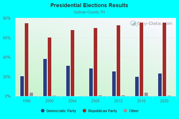
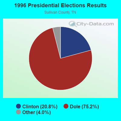
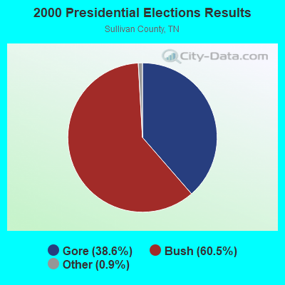
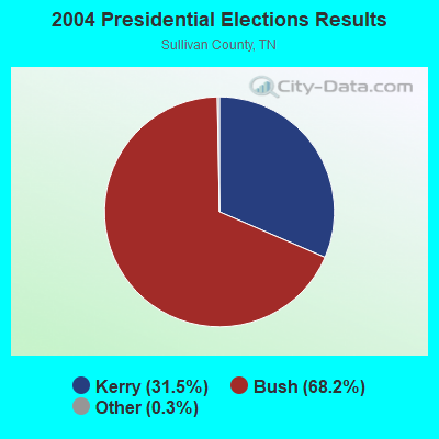
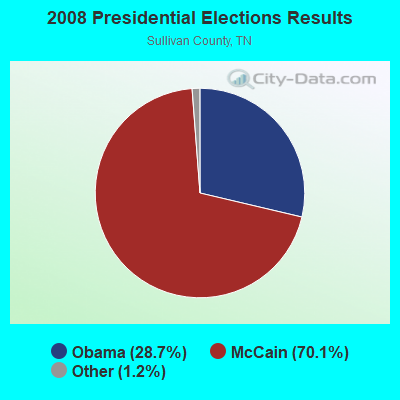

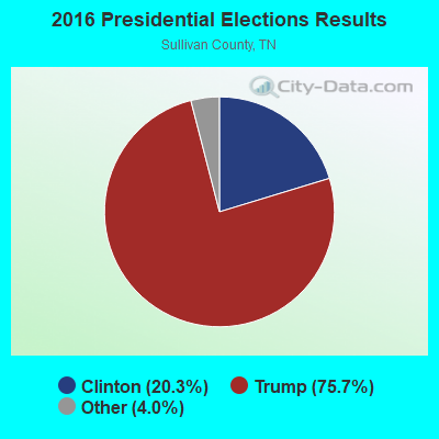

Graphs represent county-level data. Detailed 2008 Election Results
Religion statistics for Holston Valley, TN (based on Sullivan County data)
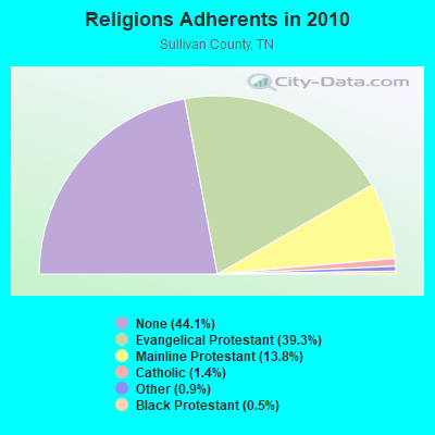
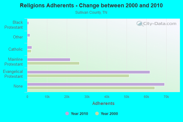
| Religion | Adherents | Congregations |
|---|---|---|
| Evangelical Protestant | 61,602 | 206 |
| Mainline Protestant | 21,586 | 74 |
| Catholic | 2,245 | 1 |
| Other | 1,368 | 8 |
| Black Protestant | 801 | 7 |
| Orthodox | 140 | 1 |
| None | 69,081 | - |
Food Environment Statistics:
| Here: | 1.30 / 10,000 pop. |
| Tennessee: | 1.99 / 10,000 pop. |
| This county: | 0.13 / 10,000 pop. |
| Tennessee: | 0.17 / 10,000 pop. |
| Sullivan County: | 0.39 / 10,000 pop. |
| Tennessee: | 0.65 / 10,000 pop. |
| Sullivan County: | 4.89 / 10,000 pop. |
| Tennessee: | 5.16 / 10,000 pop. |
| Sullivan County: | 5.93 / 10,000 pop. |
| Tennessee: | 6.56 / 10,000 pop. |
| Here: | 13.5% |
| Tennessee: | 11.4% |
| Sullivan County: | 30.2% |
| State: | 30.2% |
| This county: | 9.4% |
| Tennessee: | 13.5% |
Strongest AM radio stations in Holston Valley:
- WZAP (690 AM; 10 kW; BRISTOL, VA; Owner: RAM COMMUNICATIONS, INC.)
- WFHG (980 AM; 5 kW; BRISTOL, VA; Owner: BRISTOL BROADCASTING COMPANY, INC.)
- WBCV (1550 AM; 5 kW; BRISTOL, TN; Owner: SUNSHINE BROADCASTERS, INC.)
- WGOC (640 AM; 10 kW; BLOUNTVILLE, TN; Owner: CITADEL BROADCASTING COMPANY)
- WPWT (870 AM; daytime; 10 kW; COLONIAL HEIGHTS, TN; Owner: INFORMATION COMMUNICATIONS CORP.)
- WHGG (1090 AM; daytime; 10 kW; KINGSPORT, TN; Owner: APPALACHIAN EDUCATIONAL COMMUNICATIO)
- WOPI (1490 AM; 1 kW; BRISTOL, TN; Owner: HOLTON VALLEY BROADCASTING CORP.)
- WFGW (1010 AM; 50 kW; BLACK MOUNTAIN, NC; Owner: BLUE RIDGE BROADCASTING CORP.)
- WETB (790 AM; 5 kW; JOHNSON CITY, TN; Owner: MOUNTAIN SIGNALS, INC.)
- WJCW (910 AM; 5 kW; JOHNSON CITY, TN; Owner: CITADEL BROADCASTING COMPANY)
- WKSK (580 AM; 5 kW; W.JEFFERSON, NC; Owner: CADDELL BROADCASTING, INC.)
- WHKY (1290 AM; 50 kW; HICKORY, NC; Owner: LONG COMMUNICATIONS, LLC.)
- WKTP (1590 AM; 10 kW; JONESBOROUGH, TN; Owner: HOLSTON VALLEY BROADCASTING CORP.)
Strongest FM radio stations in Holston Valley:
- WCQR-FM (88.3 FM; KINGSPORT, TN; Owner: POSITIVE ALTERNATIVE RADIO, INC.)
- WHCB (91.5 FM; BRISTOL, TN; Owner: APPALACHIAN EDUC. COMMUNICATION CORP)
- WETS-FM (89.5 FM; JOHNSON CITY, TN; Owner: EAST TENNESSEE STATE UNIVERSITY)
- WXBQ-FM (96.9 FM; BRISTOL, TN; Owner: BRISTOL BROADCASTING COMPANY, INC.)
- W214AP (90.7 FM; JOHNSON CITY, TN; Owner: THE MOODY BIBLE INSTITUTE OF CHICAGO)
- WPJO (99.3 FM; ELIZABETHTON, TN; Owner: BRISTOL BROADCASTING COMPANY, INC.)
- WECR-FM (102.3 FM; BEECH MOUNTAIN, NC; Owner: RONDINARO BROADCASTING, INC)
- WTFM (98.5 FM; KINGSPORT, TN; Owner: HOLSTON VALLEY BROADCASTING CORP.)
- WFHG-FM (92.7 FM; ABINGDON, VA; Owner: BRISTOL BROADCASTING COMPANY, INC.)
- WZJS (100.7 FM; BANNER ELK, NC; Owner: HIGHLAND COMMUNICATIONS ASSOCIATES, LLC)
- WQUT (101.5 FM; JOHNSON CITY, TN; Owner: CITADEL BROADCASTING COMPANY)
- W285DG (104.9 FM; BOONE, NC; Owner: CITADEL BROADCASTING COMPANY)
- W225AA (92.9 FM; BOONE, NC; Owner: ISOTHERMAL COMMUNITY COLLEGE)
- WMIT (106.9 FM; BLACK MOUNTAIN, NC; Owner: BLUE RIDGE BROADCASTING CORPORATION)
- WRZK (95.9 FM; COLONIAL HEIGHTS, TN; Owner: MURRAY COMMUNICATIONS)
- WNCW (88.7 FM; SPINDALE, NC; Owner: ISOTHERMAL COMMUNITY COLLEGE)
- WMEV-FM (93.9 FM; MARION, VA; Owner: HOLSTON VALLEY BROADCASTING CORPORATION)
- WXLZ-FM (107.3 FM; LEBANON, VA; Owner: YEARY BROADCASTING, INC.)
- WOLD-FM (102.5 FM; MARION, VA; Owner: EMERALD SOUND, INC.)
- WVTR (91.9 FM; MARION, VA; Owner: VIRGINIA TECH FOUNDATION INC)
TV broadcast stations around Holston Valley:
- WCYB-TV (Channel 5; BRISTOL, VA; Owner: APPALACHIAN BROADCASTING CORP.)
- WOPI-CA (Channel 9; BRISTOL,VA/KINGSPORT, TN; Owner: HOLSTON VALLEY BROADCASTING CORPORATION)
- WKPT-TV (Channel 19; KINGSPORT, TN; Owner: HOLSTON VALLEY BROADCASTING CORP.)
- WJHL-TV (Channel 11; JOHNSON CITY, TN; Owner: MEDIA GENERAL COMMUNICATIONS, INC.)
- WAPK-CA (Channel 36; BRISTOL,VA/KINGSPORT, TN; Owner: HOLSTON VALLEY BROADCASTING CORPORATION)
FCC Registered Antenna Towers:
7- Edward G Roach, Hwy 421 And Pyle Road Junction (Lat: 36.568056 Lon: -82.047500), Type: 88.4, Overall height: 88.4 m, Registrant: Sba Towers, Inc., Eroach@sbasite.Com, , Boca -Raton, Phone: (561) 995-7670
- Edward G Roach, Hwy 421 And Pyle Road Junction (Lat: 36.568000 Lon: -82.047389), Type: 90.2, Overall height: 88.4 m, Registrant: Sba Towers, Inc., Eroach@sbasite.Com, , Boca -Raton, Phone: (561) 995-7670
- Edward G Roach, Hwy 421 And Pyle Road Junction (Lat: 36.568000 Lon: -82.047389), Type: 90.2, Overall height: 88.4 m, Registrant: Sba Towers, Inc., Eroach@sbasite.Com, , Boca -Raton, Phone: (561) 995-7670
- Edward G Roach, 5350 Hwy 421 And Pyle Road Junction (Lat: 36.568000 Lon: -82.047389), Type: 85.0, Overall height: 84.1 m, Registrant: Sba Towers, Inc., Eroach@sbasite.Com, , Boca -Raton, Phone: (561) 995-7670
- Edward G Roach, 5350 Hwy 421 And Pyle Road Junction (Lat: 36.568000 Lon: -82.047389), Type: 85.0, Overall height: 84.1 m, Registrant: Sba Towers, Inc., Eroach@sbasite.Com, , Boca -Raton, Phone: (561) 995-7670
- Edward G Roach, 5350 Hwy 421 And Pyle Road Junction (Lat: 36.568000 Lon: -82.047389), Type: 85.0, Structure height: 47163 m, Overall height: 84.1 m, Registrant: Sba Towers, LLC, Eroach@sbasite.Com, , Boca -Raton, Phone: (561) 995-7670
- Hwy 421 And Pyle Road Junction (Lat: 36.568056 Lon: -82.047500), Type: 88.4, Overall height: 88.4 m, Registrant: Sba Towers, Inc., Jwilliamson@sbasite.Com, , Boca -Raton, Phone: (561) 995-7670

- 71.0%Electricity
- 15.3%Fuel oil, kerosene, etc.
- 8.8%Wood
- 3.3%Bottled, tank, or LP gas
- 0.9%Utility gas
- 0.7%Coal or coke

- 62.6%Electricity
- 18.3%Wood
- 14.6%Fuel oil, kerosene, etc.
- 4.6%Bottled, tank, or LP gas
Holston Valley compared to Tennessee state average:
- Median household income below state average.
- Median house value below state average.
- Black race population percentage significantly below state average.
- Hispanic race population percentage significantly below state average.
- Foreign-born population percentage significantly below state average.
- Renting percentage significantly below state average.
- Length of stay since moving in significantly above state average.
- Number of rooms per house significantly below state average.
- House age significantly below state average.
- Number of college students below state average.
- Percentage of population with a bachelor's degree or higher significantly below state average.
Holston Valley on our top lists:
- #10 on the list of "Top 101 cities with the largest percentage of people in job corps and vocational training facilities (population 1,000+)"
- #1 on the list of "Top 101 counties with the worst general health status score of residents (1-5), 3 years of data"
- #25 on the list of "Top 101 counties with the lowest percentage of residents that exercised in the past month"
- #53 on the list of "Top 101 counties with the highest number of deaths per 1000 residents 2007-2013 (pop. 50,000+)"
- #56 on the list of "Top 101 counties with the smallest number of children under 18 without health insurance coverage in 2000 (pop. 50,000+)"
- #62 on the list of "Top 101 counties with highest percentage of residents voting for Romney (Republican) in the 2012 Presidential Election (pop. 50,000+)"