Marcola, Oregon

Marcola: Impenetrable....
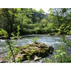
Marcola: Rock in the Mohawk ....

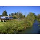
Marcola: Mohawk River...
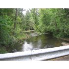
Marcola: Paschelke Bridge
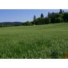
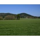
Marcola: More Grass...
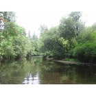
Marcola: One spot on the Mohawk River
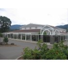
Marcola: Mohawk High School
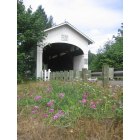
Marcola: Wendling Covered Bridge Near the Old Town of Wendling
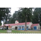
Marcola: Mohawk Volunteer Fire Department Station
Marcola: Grass...
Marcola: Ready for the next flood...
- see
18
more - add
your


Submit your own pictures of this place and show them to the world
- OSM Map
- General Map
- Google Map
- MSN Map

| Males: 2,554 | |
| Females: 2,412 |
| Median resident age: | 44.4 years |
| Oregon median age: | 36.3 years |
Zip code: 97454
| Marcola: | $87,996 |
| OR: | $75,657 |
Estimated per capita income in 2022: $46,678 (it was $25,664 in 2000)
Marcola CCD income, earnings, and wages data
Estimated median house or condo value in 2022: $598,251 (it was $187,600 in 2000)
| Marcola: | $598,251 |
| OR: | $475,600 |
Mean prices in 2022: all housing units: $467,161; detached houses: $507,773; townhouses or other attached units: $393,851; in 2-unit structures: $407,947; in 3-to-4-unit structures: $352,759; in 5-or-more-unit structures: $252,275; mobile homes: $154,945; occupied boats, rvs, vans, etc.: $16,903
Detailed information about poverty and poor residents in Marcola, OR
Compare current foreclosures near Marcola, OR:
| Photo | Address | Area | Beds / Baths | Price | Details |
|---|---|---|---|---|---|

|
#1
Mohawk River Rd
Marcola, OR 97454
|
2,706 sq. feet
|
- baths - beds |
show details | |

|
#2
Washington Aly
Eugene, OR 97401
|
1,900 sq. feet
|
3 baths 5 beds |
show details | |

|
#3
Mckenzie Hwy
Springfield, OR 97478
|
1,900 sq. feet
|
2 baths 3 beds |
show details | |

|
#4
D St
Springfield, OR 97478
|
960 sq. feet
|
1 baths 3 beds |
show details | |

|
#5
Carbona St
Eugene, OR 97404
|
912 sq. feet
|
1 baths 3 beds |
show details | |

|
#6
57th St
Springfield, OR 97478
|
876 sq. feet
|
1 baths 3 beds |
show details | |

|
#7
Alder St
Sweet Home, OR 97386
|
1,033 sq. feet
|
1 baths 3 beds |
show details | |

|
#8
15th Ave
Sweet Home, OR 97386
|
2,102 sq. feet
|
2 baths 5 beds |
show details | |

|
#9
Park Ave
Eugene, OR 97404
|
806 sq. feet
|
1 baths 2 beds |
show details | |

|
#10
Pioneer Pike
Eugene, OR 97401
|
2,008 sq. feet
|
2 baths 3 beds |
show details |
| Photo | Address | Area | Beds / Baths | Price | Details |
|---|---|---|---|---|---|

|
#11
E 25th Ave
Eugene, OR 97403
|
1,750 sq. feet
|
1 baths 3 beds |
show details | |

|
#12
El Camino St
Eugene, OR 97405
|
1,010 sq. feet
|
2 baths - beds |
show details | |

|
#13
Russet Dr
Eugene, OR 97401
|
1,489 sq. feet
|
2 baths 3 beds |
show details | |

|
#14
Norkenzie Rd Apt 56
Eugene, OR 97401
|
1,375 sq. feet
|
2 baths 3 beds |
show details | |

|
#15
Terresa Ave
Eugene, OR 97408
|
1,006 sq. feet
|
1 baths 3 beds |
show details | |

|
#16
Rio Vista Ave
Eugene, OR 97404
|
912 sq. feet
|
1 baths 3 beds |
show details | |

|
#17
Banner St
Eugene, OR 97404
|
1,901 sq. feet
|
2 baths 5 beds |
show details | |

|
#18
Hollyview Ave
Eugene, OR 97404
|
1,611 sq. feet
|
2 baths 3 beds |
show details | |

|
#19
Futura St
Eugene, OR 97404
|
2,660 sq. feet
|
2 baths 5 beds |
show details | |

|
#20
Azalea Dr
Eugene, OR 97404
|
1,368 sq. feet
|
1 baths 2 beds |
show details |
| Photo | Address | Area | Beds / Baths | Price | Details |
|---|---|---|---|---|---|

|
#21
Oroyan Ave
Eugene, OR 97404
|
864 sq. feet
|
1 baths 3 beds |
show details | |

|
#22
Birchwood Ave
Eugene, OR 97401
|
1,798 sq. feet
|
2 baths 4 beds |
show details | |

|
#23
Harlow Rd
Eugene, OR 97401
|
1,269 sq. feet
|
1 baths 2 beds |
show details | |

|
#24
Crescent Ave
Eugene, OR 97408
|
1,030 sq. feet
|
1 baths 3 beds |
show details | |

|
#25
Kentwood Dr
Eugene, OR 97401
|
2,024 sq. feet
|
2 baths 3 beds |
show details | |

|
#26
Jasper Rd
Springfield, OR 97478
|
1,136 sq. feet
|
1 baths 1 beds |
show details | |

|
#27
Osage St
Springfield, OR 97478
|
2,016 sq. feet
|
2 baths 4 beds |
show details | |

|
#28
D St
Springfield, OR 97477
|
2,816 sq. feet
|
3 baths 7 beds |
show details | |

|
#29
6th St
Springfield, OR 97477
|
1,024 sq. feet
|
1 baths 2 beds |
show details | |

|
#30
Oakdale Ave
Springfield, OR 97477
|
4,389 sq. feet
|
6 baths 6 beds |
show details |
| Photo | Address | Area | Beds / Baths | Price | Details |
|---|---|---|---|---|---|

|
#31
4th St
Springfield, OR 97477
|
1,454 sq. feet
|
1 baths 3 beds |
show details | |

|
#32
Highway 228
Sweet Home, OR 97386
|
2,314 sq. feet
|
2 baths 3 beds |
show details | |

|
#33
Belle Terra Dr
Eugene, OR 97408
|
1,298 sq. feet
|
2 baths 3 beds |
show details | |

|
#34
Owosso Dr
Eugene, OR 97404
|
1,135 sq. feet
|
1 baths 2 beds |
show details | |

|
#35
Barrington Ave
Eugene, OR 97401
|
3,314 sq. feet
|
2 baths 4 beds |
show details | |

|
#36
Hamilton St
Springfield, OR 97477
|
1,170 sq. feet
|
2 baths 3 beds |
show details | |

|
#37
Elysium Ave
Eugene, OR 97401
|
1,329 sq. feet
|
1 baths 3 beds |
show details | |

|
#38
Tamarack St
Springfield, OR 97477
|
1,465 sq. feet
|
1 baths 3 beds |
show details | |

|
#39
Randall St
Eugene, OR 97401
|
1,296 sq. feet
|
1 baths 3 beds |
show details | |

|
#40
Crescent Ave
Eugene, OR 97408
|
1,773 sq. feet
|
2 baths 4 beds |
show details |
| Photo | Address | Area | Beds / Baths | Price | Details |
|---|---|---|---|---|---|

|
#41
Coburg Bottom Loop Rd
Eugene, OR 97408
|
1,396 sq. feet
|
1 baths 3 beds |
show details | |

|
#42
Suburban Ave
Eugene, OR 97404
|
1,818 sq. feet
|
1 baths 3 beds |
show details | |

|
#43
Maynard Ave
Eugene, OR 97404
|
1,556 sq. feet
|
2 baths 3 beds |
show details | |

|
#44
E Anchor Ave
Eugene, OR 97404
|
2,190 sq. feet
|
1 baths 3 beds |
show details | |

|
#45
Skipper Ave
Eugene, OR 97404
|
816 sq. feet
|
1 baths 2 beds |
show details | |

|
#46
Shenstone Dr
Eugene, OR 97404
|
1,481 sq. feet
|
2 baths 3 beds |
show details | |

|
#47
Stillman Ave
Eugene, OR 97404
|
1,040 sq. feet
|
1 baths 3 beds |
show details | |

|
#48
Dexter Rd
Dexter, OR 97431
|
1,538 sq. feet
|
1 baths 3 beds |
show details | |

|
#49
Dexter Rd
Dexter, OR 97431
|
1,104 sq. feet
|
1 baths 2 beds |
show details | |

|
Check over 1 million property listings on Foreclosure.com!
|
browse all offers | |||

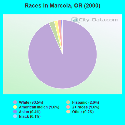
- 4,35793.5%White alone
- 1202.6%Hispanic
- 761.6%American Indian alone
- 761.6%Two or more races
- 190.4%Asian alone
- 70.2%Other race alone
- 50.1%Black alone
Races in Marcola detailed stats: ancestries, foreign born residents, place of birth
According to our research of Oregon and other state lists, there was 1 registered sex offender living in Marcola, Oregon as of April 26, 2024.
The ratio of all residents to sex offenders in Marcola is 4,966 to 1.
The ratio of registered sex offenders to all residents in this city is lower than the state average.
 Recent articles from our blog. Our writers, many of them Ph.D. graduates or candidates, create easy-to-read articles on a wide variety of topics.

Current Local Time: PST time zone
Elevation: 560 feet
Land area: 199.0 square miles.
Population density: 25 people per square mile (very low).

| Marcola CCD: | 0.8% ($1,554) |
| Oregon: | 1.2% ($1,687) |
Nearest city with pop. 50,000+: Springfield, OR  (11.6 miles , pop. 52,864).
Nearest city with pop. 200,000+: Northwest Clackamas, OR (85.4 miles , pop. 224,220).
Nearest city with pop. 1,000,000+: Los Angeles, CA (737.0 miles , pop. 3,694,820).
Nearest cities:
), ), Latitude: 44.17 N, Longitude: 122.83 W
Area code: 541

| Here: | 4.2% |
| Oregon: | 3.9% |
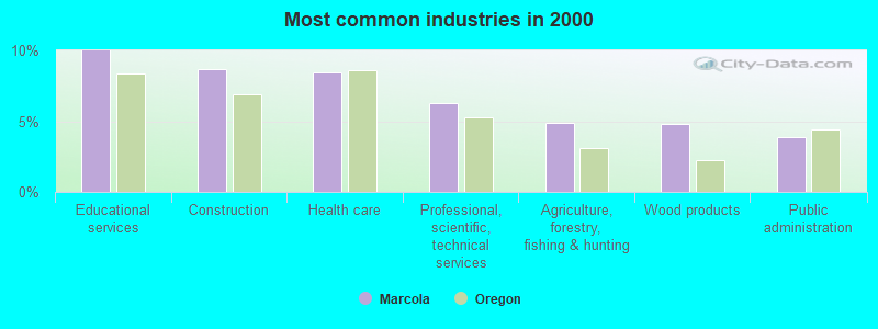
- Educational services (10.0%)
- Construction (8.7%)
- Health care (8.4%)
- Professional, scientific, technical services (6.3%)
- Agriculture, forestry, fishing & hunting (4.9%)
- Wood products (4.8%)
- Public administration (3.9%)
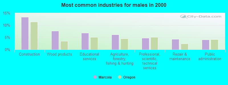
- Construction (13.4%)
- Wood products (7.6%)
- Educational services (6.9%)
- Agriculture, forestry, fishing & hunting (6.2%)
- Professional, scientific, technical services (4.8%)
- Repair & maintenance (4.3%)
- Public administration (4.1%)
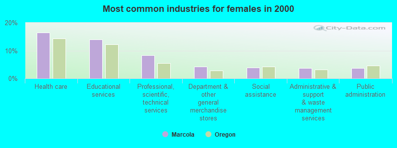
- Health care (16.4%)
- Educational services (14.0%)
- Professional, scientific, technical services (8.3%)
- Department & other general merchandise stores (4.2%)
- Social assistance (3.8%)
- Administrative & support & waste management services (3.7%)
- Public administration (3.6%)
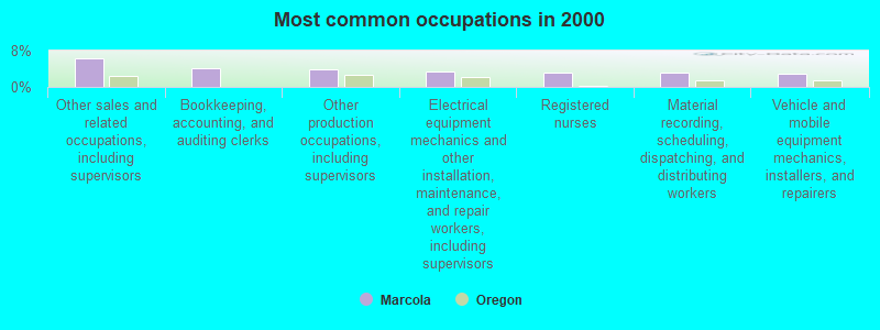
- Other sales and related occupations, including supervisors (6.4%)
- Bookkeeping, accounting, and auditing clerks (4.2%)
- Other production occupations, including supervisors (3.8%)
- Electrical equipment mechanics and other installation, maintenance, and repair workers, including supervisors (3.4%)
- Registered nurses (3.3%)
- Material recording, scheduling, dispatching, and distributing workers (3.1%)
- Vehicle and mobile equipment mechanics, installers, and repairers (2.9%)
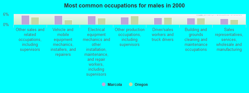
- Other sales and related occupations, including supervisors (5.5%)
- Vehicle and mobile equipment mechanics, installers, and repairers (5.2%)
- Electrical equipment mechanics and other installation, maintenance, and repair workers, including supervisors (5.1%)
- Other production occupations, including supervisors (4.4%)
- Driver/sales workers and truck drivers (4.0%)
- Building and grounds cleaning and maintenance occupations (3.8%)
- Sales representatives, services, wholesale and manufacturing (3.5%)

- Bookkeeping, accounting, and auditing clerks (9.5%)
- Other sales and related occupations, including supervisors (7.5%)
- Registered nurses (7.1%)
- Secretaries and administrative assistants (6.3%)
- Preschool, kindergarten, elementary, and middle school teachers (4.6%)
- Material recording, scheduling, dispatching, and distributing workers (3.8%)
- Information and record clerks, except customer service representatives (3.6%)
Average climate in Marcola, Oregon
Based on data reported by over 4,000 weather stations


(lower is better)
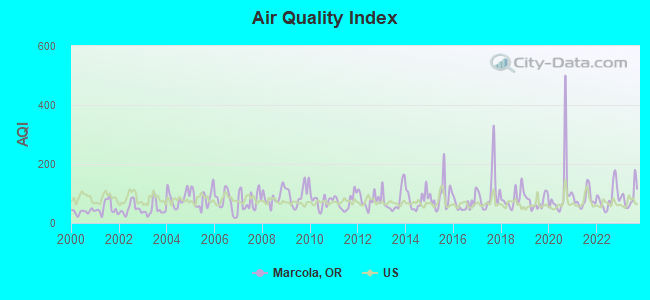
Air Quality Index (AQI) level in 2023 was 88.7. This is worse than average.
| City: | 88.7 |
| U.S.: | 72.6 |
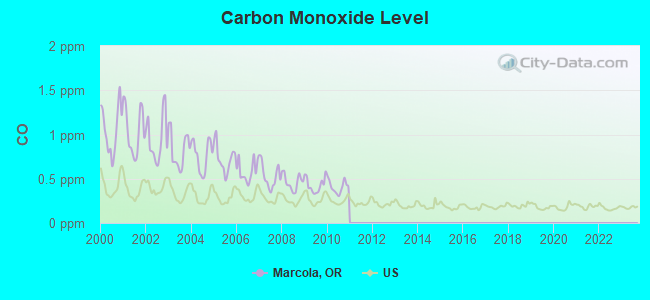
Carbon Monoxide (CO) [ppm] level in 2010 was 0.410. This is significantly worse than average. Closest monitor was 15.4 miles away from the city center.
| City: | 0.410 |
| U.S.: | 0.251 |
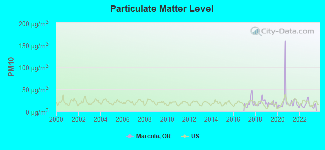
Particulate Matter (PM10) [µg/m3] level in 2022 was 16.0. This is about average. Closest monitor was 9.9 miles away from the city center.
| City: | 16.0 |
| U.S.: | 19.2 |
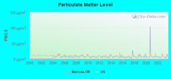
Particulate Matter (PM2.5) [µg/m3] level in 2023 was 5.85. This is better than average. Closest monitor was 9.9 miles away from the city center.
| City: | 5.85 |
| U.S.: | 8.11 |
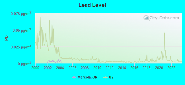
Lead (Pb) [µg/m3] level in 2003 was 0.00258. This is significantly better than average. Closest monitor was 12.9 miles away from the city center.
| City: | 0.00258 |
| U.S.: | 0.00931 |
Earthquake activity:
Marcola-area historical earthquake activity is significantly above Oregon state average. It is 2357% greater than the overall U.S. average.On 1/31/1922 at 13:17:28, a magnitude 7.6 (7.6 UK, Class: Major, Intensity: VIII - XII) earthquake occurred 277.5 miles away from the city center
On 11/8/1980 at 10:27:34, a magnitude 7.2 (6.2 MB, 7.2 MS, 7.2 MW, 7.0 ML) earthquake occurred 224.7 miles away from the city center
On 8/17/1991 at 22:17:14, a magnitude 7.1 (6.2 MB, 7.1 MS, 7.1 MW, 6.8 ML, Depth: 8.4 mi) earthquake occurred 218.2 miles away from Marcola center
On 6/15/2005 at 02:50:54, a magnitude 7.2 (7.2 MW, Depth: 9.9 mi) earthquake occurred 254.7 miles away from the city center
On 4/13/1949 at 19:55:42, a magnitude 7.0 (7.0 UK) earthquake occurred 213.5 miles away from the city center, causing $80,000,000 total damage
On 6/15/2005 at 02:50:54, a magnitude 7.2 (6.1 MB, 7.1 MS, 7.2 MW, 7.1 MW) earthquake occurred 260.7 miles away from Marcola center
Magnitude types: body-wave magnitude (MB), local magnitude (ML), surface-wave magnitude (MS), moment magnitude (MW)
Natural disasters:
The number of natural disasters in Lane County (17) is near the US average (15).Major Disasters (Presidential) Declared: 13
Emergencies Declared: 1
Causes of natural disasters: Floods: 10, Winter Storms: 7, Storms: 6, Winds: 4, Landslides: 3, Mudslides: 3, Fire: 1, Heavy Rain: 1, Hurricane: 1, Snow: 1, Other: 1 (Note: some incidents may be assigned to more than one category).
Hospitals and medical centers near Marcola:
- MCKENZIE-WILLAMETTE MEDICAL CENTER Acute Care Hospitals (about 13 miles away; SPRINGFIELD, OR)
- QUALICENTERS - EUGENE-SPRINGFIELD LTD (Dialysis Facility, about 13 miles away; SPRINGFIELD, OR)
- GREEN VALLEY CARE CENTER (Nursing Home, about 14 miles away; EUGENE, OR)
- GREEN VALLEY REHABILITATION HEALTH CENTER (Nursing Home, about 14 miles away; EUGENE, OR)
- TWILIGHT ACRES NURSING HOME (Nursing Home, about 15 miles away; EUGENE, OR)
- SACRED HEART HOME HEALTH (Home Health Center, about 16 miles away; EUGENE, OR)
- SACRED HEART UNIVERSITY DISTRICT Acute Care Hospitals (about 16 miles away; EUGENE, OR)
Amtrak station near Marcola:
- 16 miles: EUGENE-SPRINGFIELD (EUGENE, 433 WILLAMETTE ST.) . Services: ticket office, partially wheelchair accessible, enclosed waiting area, public restrooms, public payphones, full-service food facilities, paid short-term parking, call for car rental service, call for taxi service, public transit connection.
Colleges/universities with over 2000 students nearest to Marcola:
- University of Oregon (about 16 miles; Eugene, OR; Full-time enrollment: 23,329)
- Lane Community College (about 16 miles; Eugene, OR; FT enrollment: 6,373)
- Linn-Benton Community College (about 33 miles; Albany, OR; FT enrollment: 4,511)
- Oregon State University (about 35 miles; Corvallis, OR; FT enrollment: 23,206)
- Western Oregon University (about 52 miles; Monmouth, OR; FT enrollment: 5,131)
- Willamette University (about 54 miles; Salem, OR; FT enrollment: 2,551)
- Chemeketa Community College (about 57 miles; Salem, OR; FT enrollment: 10,746)
Public high school in Marcola:
- MOHAWK HIGH SCHOOL (Students: 137, Location: 38300 WENDLING RD, Grades: 7-12)
Public elementary/middle school in Marcola:
- MARCOLA ELEMENTARY SCHOOL (Students: 102, Location: 92250 SCHOOL HOUSE RD, Grades: KG-6)
Points of interest:
Notable locations in Marcola: Wendling Picnic Area (A), Berrlinger Landing Boat Ramp (B), Springfield Country Club (C), McKenzie Fire and Rescue Station 2 - Camp Creek Station (D), Mohawk Valley Rural Fire District Station 2 (E), Mohawk Valley Rural Fire District Station 3 (F), Mohawk Valley Rural Fire District Station 1 (G), Mohawk Valley Rural Fire District Station 4 (H), Mohawk Valley Rural Fire District Station 5 (I). Display/hide their locations on the map
Church in Marcola: Marcola Christian Church (A). Display/hide its location on the map
Cemeteries: Stafford Cemetery (1), Camp Creek Cemetery (2), Mabel Cemetery (3), Mohawk Community Church Cemetery (4), Drury Cemetery (5), Marcola Cemetery (6). Display/hide their locations on the map
Lakes and reservoirs: Ernests Pond (A), Bedortha Reservoir (B). Display/hide their locations on the map
Streams, rivers, and creeks: Beal Creek (A), Solomon Creek (B), Spores Creek (C), Clear Creek (D), Small Creek (E), Whiskey Creek (F), Seeley Creek (G), Alder Branch (H), Allison Creek (I). Display/hide their locations on the map
Parks in Marcola include: Bellinger Landing County Park (1), Douglas Gardens Park (2), Mabel Park (3), Shotgun Recreational Site (4). Display/hide their locations on the map
| This place: | 2.5 people |
| Oregon: | 2.5 people |
| This place: | 74.6% |
| Whole state: | 63.4% |
| This place: | 6.7% |
| Whole state: | 8.0% |
Likely homosexual households (counted as self-reported same-sex unmarried-partner households)
- Lesbian couples: 0.7% of all households
- Gay men: 0.3% of all households
| This place: | 5.8% |
| Whole state: | 11.6% |
| This place: | 1.7% |
| Whole state: | 5.0% |
2 people in group homes intended for adults in 2010
4 people in other nonhousehold living situations in 2000
For population 15 years and over in Marcola:
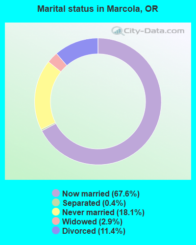
- Never married: 18.1%
- Now married: 67.6%
- Separated: 0.4%
- Widowed: 2.9%
- Divorced: 11.4%
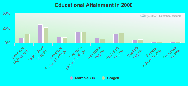
For population 25 years and over in Marcola:
- High school or higher: 91.1%
- Bachelor's degree or higher: 22.4%
- Graduate or professional degree: 7.2%
- Unemployed: 5.1%
- Mean travel time to work (commute): 24.4 minutes
| Here: | 9.4 |
| Oregon average: | 11.5 |
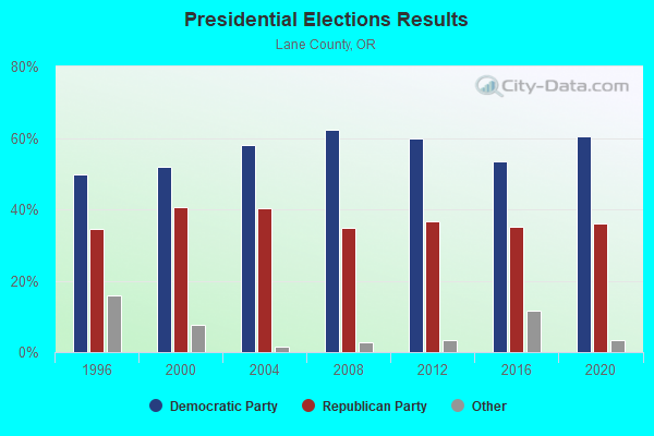
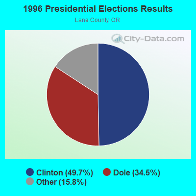
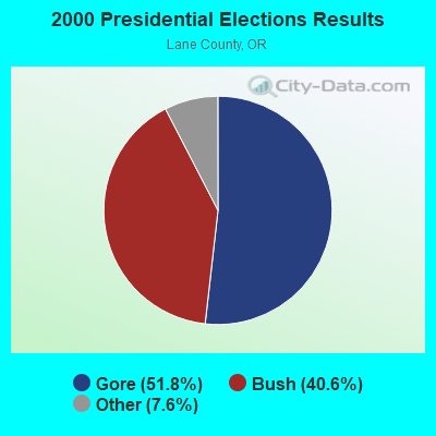
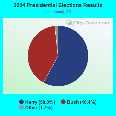
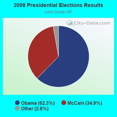
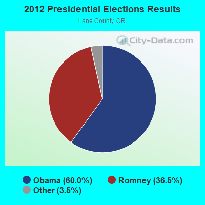
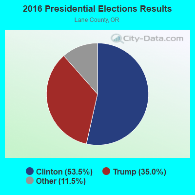
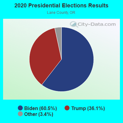
Graphs represent county-level data. Detailed 2008 Election Results
Religion statistics for Marcola, OR (based on Lane County data)
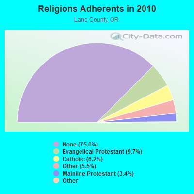
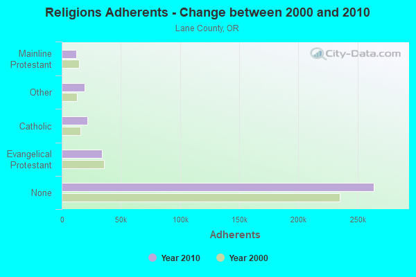
| Religion | Adherents | Congregations |
|---|---|---|
| Evangelical Protestant | 34,051 | 216 |
| Catholic | 21,785 | 15 |
| Other | 19,303 | 72 |
| Mainline Protestant | 12,082 | 50 |
| Black Protestant | 295 | 2 |
| Orthodox | 240 | 2 |
| None | 263,959 | - |
Food Environment Statistics:
| This county: | 1.95 / 10,000 pop. |
| Oregon: | 2.03 / 10,000 pop. |
| Lane County: | 0.44 / 10,000 pop. |
| Oregon: | 0.33 / 10,000 pop. |
| This county: | 2.68 / 10,000 pop. |
| Oregon: | 2.01 / 10,000 pop. |
| Lane County: | 1.69 / 10,000 pop. |
| Oregon: | 1.69 / 10,000 pop. |
| Here: | 8.40 / 10,000 pop. |
| Oregon: | 9.93 / 10,000 pop. |
| Lane County: | 6.5% |
| State: | 7.4% |
| Lane County: | 26.1% |
| State: | 25.6% |
| Lane County: | 15.3% |
| Oregon: | 14.2% |
Strongest AM radio stations in Marcola:
- KPNW (1120 AM; 50 kW; EUGENE, OR; Owner: CAPSTAR TX LIMITED PARTNERSHIP)
- KUGN (590 AM; 5 kW; EUGENE, OR; Owner: CUMULUS LICENSING CORP.)
- KZTU (660 AM; 10 kW; JUNCTION CITY, OR; Owner: PAMPLIN BROADCASTING-OREGON, INC.)
- KORE (1050 AM; 5 kW; SPRINGFIELD-EUGENE, OR; Owner: SUPPORT CHRISTIAN BROADCASTING)
- KRVM (1280 AM; 5 kW; EUGENE, OR; Owner: LANE COUNTY SCHOOL DISTRICT 4J)
- KEED (1600 AM; 5 kW; EUGENE, OR; Owner: INTEGRITY MEDIA INCORPORATED)
- KDUN (1030 AM; 50 kW; REEDSPORT, OR; Owner: PAMPLIN BROADCASTING-OREGON, INC.)
- KPOJ (620 AM; 50 kW; PORTLAND, OR; Owner: CITICASTERS LICENSES, L.P.)
- KXL (750 AM; 50 kW; PORTLAND, OR; Owner: ROSE CITY RADIO CORPORATION)
- KOAC (550 AM; 5 kW; CORVALLIS, OR; Owner: OREGON PUBLIC BROADCASTING)
- KEX (1190 AM; 50 kW; PORTLAND, OR; Owner: CITICASTERS LICENSES, L.P.)
- KPAM (860 AM; 50 kW; TROUTDALE, OR; Owner: PAMPLIN BROADCASTING-OREGON, INC.)
- KGRV (700 AM; 25 kW; WINSTON, OR; Owner: PACIFIC CASCADE COMMUNICATIONS CORP.)
Strongest FM radio stations in Marcola:
- K207BX (89.3 FM; EUGENE, OR; Owner: PENSACOLA CHRISTIAN COLLEGE, INC.)
- K203BT (88.5 FM; EUGENE, OR; Owner: CALVARY CHAPEL OF TWIN FALLS, INC.)
- K214CI (90.7 FM; EUGENE, OR; Owner: EDUCATIONAL MEDIA FOUNDATION)
- KODZ (99.1 FM; EUGENE, OR; Owner: CAPSTAR TX LIMITED PARTNERSHIP)
- KLVU (107.1 FM; SWEET HOME, OR; Owner: EDUCATIONAL MEDIA FOUNDATION)
- KUJZ (95.3 FM; CRESWELL, OR; Owner: CUMULUS LICENSING CORP.)
- KKNU (93.1 FM; SPRINGFIELD-EUGENE, OR; Owner: MCKENZIE RIVER BROADCASTING COMPANY, INC.)
- KMGE (94.5 FM; EUGENE, OR; Owner: MCKENZIE RIVER BROADCASTING COMPANY, INC.)
- KZEL-FM (96.1 FM; EUGENE, OR; Owner: CUMULUS LICENSING CORP.)
- KNRQ-FM (97.9 FM; EUGENE, OR; Owner: CUMULUS LICENSING CORP.)
- KWAX (91.1 FM; EUGENE, OR; Owner: STATE OF OREGON ACTING BY & THROUGH)
- KLCC (89.7 FM; EUGENE, OR; Owner: LANE COMMUNITY COLLEGE)
- KDUK-FM (104.7 FM; FLORENCE, OR; Owner: CAPSTAR TX LIMITED PARTNERSHIP)
- KQFE (88.9 FM; SPRINGFIELD, OR; Owner: FAMILY STATIONS, INC.)
- KFLY (101.5 FM; CORVALLIS, OR; Owner: CITICASTERS LICENSES, L.P.)
- KWVA (88.1 FM; EUGENE, OR; Owner: ASSOC. STUDENTS OF THE UNIV. ORGEON)
- K245AA (96.9 FM; EUGENE, OR; Owner: ALBANY RADIO CORPORATION)
- KEHK (102.3 FM; BROWNSVILLE, OR; Owner: CUMULUS LICENSING CORP.)
- K265DF (100.9 FM; EUGENE, OR; Owner: EDUCATIONAL MEDIA FOUNDATION)
- K275AA (102.9 FM; SPRINGFIELD, OR; Owner: CUMULUS LICENSING CORP.)
TV broadcast stations around Marcola:
- KMTR (Channel 16; EUGENE, OR; Owner: ACKERLEY MEDIA GROUP, INC.)
- KEZI (Channel 9; EUGENE, OR; Owner: KEZI, INC.)
- KLSR-TV (Channel 34; EUGENE, OR; Owner: CALIFORNIA OREGON BROADCASTING, INC.)
- KVAL-TV (Channel 13; EUGENE, OR; Owner: FISHER BROADCASTING - OREGON TV, L.L.C.)
- KEPB-TV (Channel 28; EUGENE, OR; Owner: OREGON PUBLIC BROADCASTING)
- KEVU-LP (Channel 23; EUGENE, OR; Owner: CALIFORNIA OREGON BROADCASTING, INC.)
- K59DJ (Channel 59; EUGENE, OR; Owner: HIS WORD BROADCASTING CO.)
- KAMK-LP (Channel 53; EUGENE, OR; Owner: ROSEBURG BROADCASTING, INC.)
- KMOR-LP (Channel 51; EUGENE, OR; Owner: ACKERLEY MEDIA GROUP, INC.)
- K36FJ (Channel 36; EUGENE, OR; Owner: THREE ANGELS BROADCASTING NETWORK, INC.)
- K21FS (Channel 21; EUGENE, OR; Owner: OREGON PUBLIC BROADCASTING)
- K57EL (Channel 57; EUGENE, ETC., OR; Owner: CALIFORNIA OREGON BROADCASTING, INC.)
- K65ER (Channel 65; EUGENE, ETC., OR; Owner: CALIFORNIA OREGON BROADCASTING, INC.)
FCC Registered Cell Phone Towers:
1- Tl#1499 Sec 13 T16s R2w (97940) (Lat: 44.174556 Lon: -122.867861), Type: Tank, Structure height: 5.2 m, Call Sign: KNKA653
Assigned Frequencies: 869.040 MHz, 869.040 MHz, 869.040 MHz, 824.040 MHz, 824.040 MHz, 824.040 MHz, 890.010 MHz, 890.010 MHz, 890.010 MHz, 845.010 MHz, 845.010 MHz, 845.010 MHzGrant Date: 10/17/2017, Expiration Date: 10/01/2027, Certifier: David C JatlowRegistrant: At&t Services, Inc., 208 S Akard St, 20f, Dallas, TX 75202, Phone: (855) 699-7073, Fax: (214) 746-6410, Email:
FCC Registered Broadcast Land Mobile Towers:
1- DISTRICT, Lat: 44.170944 Lon: -122.853694, Call Sign: WQYV392,
Assigned Frequencies: 467.212 MHz, Grant Date: 02/01/2017, Expiration Date: 02/01/2027, Certifier: Bill Watkins, Registrant: Innovation Wireless, 5306 Beethoven St, Los Angeles, CA 90066, Phone: (888) 559-5565, Fax: (310) 482-3480, Email:
FCC Registered Microwave Towers:
1- MARCOLA, 38300 Wendling Road (Lat: 44.170778 Lon: -122.853556), Type: Building, Structure height: 12.8 m, Overall height: 14.6 m, Call Sign: WQQJ204,
Assigned Frequencies: 11465.0 MHz, Grant Date: 01/04/2023, Expiration Date: 01/03/2033, Certifier: Russell A Rubrecht, Registrant: Freewire Broadband LLC, 7327 Sw Barnes Road #702, Portland, OR 97225, Phone: (503) 614-8282, Fax: (503) 614-8283, Email:
FCC Registered Amateur Radio Licenses:
22 (See the full list of FCC Registered Amateur Radio Licenses in Marcola)2002 - 2018 National Fire Incident Reporting System (NFIRS) incidents
- Fire incident types reported to NFIRS in Marcola, OR
- 5945.0%Outside Fires
- 4332.8%Structure Fires
- 2317.6%Mobile Property/Vehicle Fires
- 64.6%Other
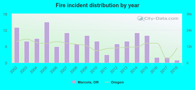 Based on the data from the years 2002 - 2018 the average number of fires per year is 8. The highest number of fire incidents - 15 took place in 2005, and the least - 1 in 2018. The data has a decreasing trend.
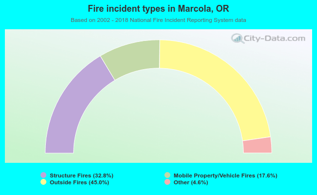 When looking into fire subcategories, the most reports belonged to: Outside Fires (45.0%), and Structure Fires (32.8%).
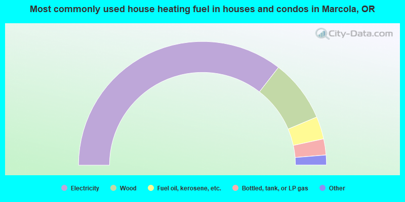
- 71.0%Electricity
- 16.3%Wood
- 5.9%Fuel oil, kerosene, etc.
- 4.2%Bottled, tank, or LP gas
- 1.2%Solar energy
- 0.5%Other fuel
- 0.5%No fuel used
- 0.4%Utility gas
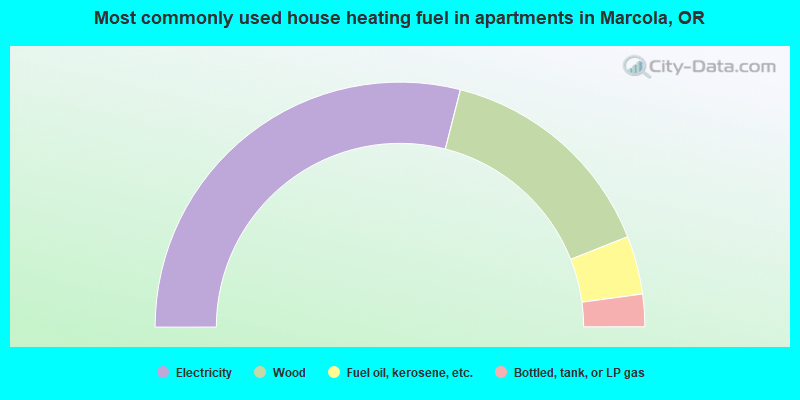
- 57.9%Electricity
- 30.0%Wood
- 7.7%Fuel oil, kerosene, etc.
- 4.3%Bottled, tank, or LP gas
Marcola compared to Oregon state average:
- Unemployed percentage significantly below state average.
- Black race population percentage significantly below state average.
- Hispanic race population percentage significantly below state average.
- Median age above state average.
- Foreign-born population percentage significantly below state average.
- Renting percentage significantly below state average.
- Length of stay since moving in significantly above state average.
- Number of rooms per house significantly below state average.
- House age significantly below state average.

|
Total of 3 patent applications in 2008-2024.