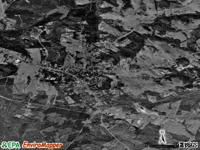
Maysville, Georgia
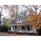
Maysville: Victorian Maysville GA, small town style
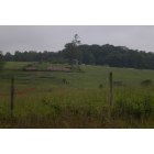
Maysville: Country setting in Town of Maysville, GA
- add
your


Submit your own pictures of this town and show them to the world
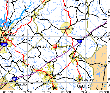
- OSM Map
- General Map
- Google Map
- MSN Map
Population change since 2000: +65.0%
| Males: 895 | |
| Females: 1,163 |
| Median resident age: | 42.2 years |
| Georgia median age: | 37.6 years |
Zip codes: 30558.
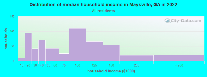
| Maysville: | $58,988 |
| GA: | $72,837 |
Estimated per capita income in 2022: $27,897 (it was $17,153 in 2000)
Maysville town income, earnings, and wages data
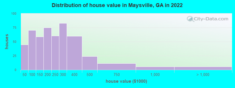
Estimated median house or condo value in 2022: $215,763 (it was $82,600 in 2000)
| Maysville: | $215,763 |
| GA: | $297,400 |
Mean prices in 2022: all housing units: $232,288; detached houses: $253,818; mobile homes: $81,111
Median gross rent in 2022: $774.
(6.4% for White Non-Hispanic residents, 50.0% for two or more races residents)
Detailed information about poverty and poor residents in Maysville, GA
Compare current foreclosures near Maysville, GA:
| Photo | Address | Area | Beds / Baths | Price | Details |
|---|---|---|---|---|---|

|
#1
Grove Dr
Maysville, GA 30558
|
1,280 sq. feet
|
2 baths 3 beds |
show details | |

|
#2
Ervin Chambers Rd
Maysville, GA 30558
|
2,147 sq. feet
|
2 baths 3 beds |
show details | |

|
#3
Meeks Rd
Maysville, GA 30558
|
1,420 sq. feet
|
1 baths - beds |
show details | |

|
#4
Beacon Dr
Maysville, GA 30558
|
1,765 sq. feet
|
2 baths - beds |
show details | |

|
#5
Highland Way
Maysville, GA 30558
|
- sq. feet
|
- baths - beds |
show details | |

|
#6
Green Hill Ct
Maysville, GA 30558
|
- sq. feet
|
- baths - beds |
show details | |

|
#7
Law Rd
Maysville, GA 30558
|
- sq. feet
|
- baths - beds |
show details | |

|
#8
Rock Forge Ct
Jefferson, GA 30549
|
1,176 sq. feet
|
2 baths 2 beds |
$305,000
|
show details |

|
#9
Chestia Dr
Gainesville, GA 30507
|
1,008 sq. feet
|
2 baths 3 beds |
$290,000
|
show details |

|
#10
Danielsville St
Danielsville, GA 30633
|
1,652 sq. feet
|
2 baths 3 beds |
show details |
| Photo | Address | Area | Beds / Baths | Price | Details |
|---|---|---|---|---|---|

|
#11
Little Cir
Gainesville, GA 30506
|
1,458 sq. feet
|
1 baths 3 beds |
show details | |

|
#12
Silver Shoals Rd
Lula, GA 30554
|
2,352 sq. feet
|
2 baths 3 beds |
show details | |

|
#13
Kay Dr
Winder, GA 30680
|
1,697 sq. feet
|
2 baths 3 beds |
show details | |

|
#14
Emily Forest Way
Pendergrass, GA 30567
|
- sq. feet
|
2 baths 4 beds |
show details | |

|
#15
Buena Vista Cir
Gainesville, GA 30504
|
1,360 sq. feet
|
2 baths 3 beds |
show details | |

|
#16
Mangum Mill Rd
Gainesville, GA 30507
|
1,242 sq. feet
|
1 baths 3 beds |
show details | |

|
#17
Moon Bridge Rd
Winder, GA 30680
|
2,130 sq. feet
|
2 baths 3 beds |
show details | |

|
#18
Old Forge Ln
Jefferson, GA 30549
|
2,888 sq. feet
|
4 baths 4 beds |
show details | |

|
#19
Longview Dr
Gainesville, GA 30501
|
1,254 sq. feet
|
2 baths 3 beds |
show details | |

|
#20
Primrose Dr
Braselton, GA 30517
|
1,326 sq. feet
|
2 baths 3 beds |
show details |
| Photo | Address | Area | Beds / Baths | Price | Details |
|---|---|---|---|---|---|

|
#21
7th St
Lula, GA 30554
|
1,280 sq. feet
|
1 baths 3 beds |
show details | |

|
#22
Cobb St
Lula, GA 30554
|
3,186 sq. feet
|
1 baths 3 beds |
show details | |

|
#23
Jefferson Hwy
Winder, GA 30680
|
2,352 sq. feet
|
2 baths 2 beds |
show details | |

|
#24
J S Williamson Ct
Nicholson, GA 30565
|
672 sq. feet
|
1 baths 3 beds |
show details | |

|
#25
Overland Park Dr
Braselton, GA 30517
|
1,971 sq. feet
|
2 baths 3 beds |
show details | |

|
#26
Prospect Rd
Toccoa, GA 30577
|
1,248 sq. feet
|
2 baths 3 beds |
show details | |

|
#27
Melinda Ln
Gainesville, GA 30507
|
3,138 sq. feet
|
2 baths 3 beds |
show details | |

|
#28
Old Ivey Ln
Gainesville, GA 30506
|
7,994 sq. feet
|
4 baths 5 beds |
show details | |

|
#29
Wilson Cemetery Rd
Nicholson, GA 30565
|
1,620 sq. feet
|
2 baths 3 beds |
show details | |

|
#30
Heartwood Way
Alto, GA 30510
|
1,512 sq. feet
|
2 baths 3 beds |
show details |
| Photo | Address | Area | Beds / Baths | Price | Details |
|---|---|---|---|---|---|

|
#31
Samples Scales Rd
Homer, GA 30547
|
1,166 sq. feet
|
1 baths 3 beds |
show details | |

|
#32
Roy Parks Rd
Gainesville, GA 30507
|
1,248 sq. feet
|
1 baths 3 beds |
show details | |

|
#33
Highway 52
Gainesville, GA 30507
|
1,350 sq. feet
|
2 baths 3 beds |
show details | |

|
#34
Plum Creek Dr
Gainesville, GA 30507
|
1,400 sq. feet
|
2 baths 3 beds |
show details | |

|
#35
Barrett Rd
Gainesville, GA 30507
|
840 sq. feet
|
1 baths 3 beds |
show details | |

|
#36
Woodlin Rd
Lula, GA 30554
|
2,448 sq. feet
|
4 baths 5 beds |
show details | |

|
#37
E Vale Cir
Gainesville, GA 30507
|
1,978 sq. feet
|
2 baths 3 beds |
show details | |

|
#38
Ila Rd
Commerce, GA 30530
|
1,048 sq. feet
|
1 baths 2 beds |
show details | |

|
#39
E Hall Rd
Gainesville, GA 30507
|
2,927 sq. feet
|
3 baths 5 beds |
show details | |

|
#40
Boone St SE
Gainesville, GA 30501
|
1,176 sq. feet
|
3 baths 4 beds |
show details |
| Photo | Address | Area | Beds / Baths | Price | Details |
|---|---|---|---|---|---|

|
#41
Lakeview Pl
Gainesville, GA 30501
|
1,381 sq. feet
|
1 baths 3 beds |
show details | |

|
#42
A C Carey Rd
Danielsville, GA 30633
|
1,232 sq. feet
|
2 baths 2 beds |
show details | |

|
#43
Ebenezer Church Rd
Jefferson, GA 30549
|
1,368 sq. feet
|
2 baths - beds |
show details | |

|
#44
Drew Ln
Athens, GA 30607
|
1,680 sq. feet
|
2 baths 3 beds |
show details | |

|
#45
Farmbrook Ln
Gainesville, GA 30507
|
1,646 sq. feet
|
2 baths 3 beds |
show details | |

|
#46
Highway 326
Carnesville, GA 30521
|
1,680 sq. feet
|
2 baths 3 beds |
show details | |

|
#47
Caney Fork Cir
Braselton, GA 30517
|
2,481 sq. feet
|
2 baths 4 beds |
show details | |

|
#48
Young Harris Rd
Danielsville, GA 30633
|
1,456 sq. feet
|
2 baths 3 beds |
show details | |

|
#49
A C Smith Rd
Commerce, GA 30530
|
1,904 sq. feet
|
2 baths 4 beds |
show details | |

|
Check over 1 million property listings on Foreclosure.com!
|
browse all offers | |||


- 1,44085.0%White alone
- 1498.8%Hispanic
- 462.7%Two or more races
- 291.7%Asian alone
- 130.8%Black alone
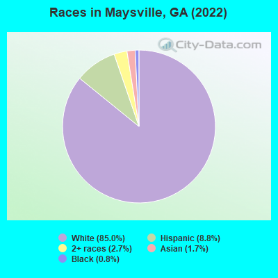
Races in Maysville detailed stats: ancestries, foreign born residents, place of birth
According to our research of Georgia and other state lists, there were 30 registered sex offenders living in Maysville, Georgia as of May 05, 2024.
The ratio of all residents to sex offenders in Maysville is 79 to 1.
Type |
2009 |
2010 |
2011 |
2012 |
2013 |
2014 |
2015 |
2016 |
2017 |
2018 |
2019 |
2020 |
2021 |
2022 |
|---|---|---|---|---|---|---|---|---|---|---|---|---|---|---|
| Murders (per 100,000) | 0 (0.0) | 0 (0.0) | 0 (0.0) | 0 (0.0) | 0 (0.0) | 0 (0.0) | 0 (0.0) | 0 (0.0) | 0 (0.0) | 0 (0.0) | 0 (0.0) | 0 (0.0) | 0 (0.0) | 0 (0.0) |
| Rapes (per 100,000) | 0 (0.0) | 0 (0.0) | 0 (0.0) | 0 (0.0) | 0 (0.0) | 0 (0.0) | 0 (0.0) | 0 (0.0) | 1 (52.6) | 0 (0.0) | 0 (0.0) | 0 (0.0) | 0 (0.0) | 0 (0.0) |
| Robberies (per 100,000) | 0 (0.0) | 0 (0.0) | 0 (0.0) | 0 (0.0) | 0 (0.0) | 0 (0.0) | 0 (0.0) | 0 (0.0) | 1 (52.6) | 0 (0.0) | 0 (0.0) | 0 (0.0) | 0 (0.0) | 0 (0.0) |
| Assaults (per 100,000) | 5 (292.2) | 3 (166.9) | 4 (219.5) | 9 (493.7) | 4 (222.8) | 1 (54.5) | 3 (163.2) | 0 (0.0) | 0 (0.0) | 2 (102.2) | 0 (0.0) | 0 (0.0) | 0 (0.0) | 0 (0.0) |
| Burglaries (per 100,000) | 6 (350.7) | 7 (389.3) | 2 (109.8) | 6 (329.1) | 3 (167.1) | 0 (0.0) | 8 (435.3) | 4 (213.2) | 1 (52.6) | 1 (51.1) | 2 (98.4) | 0 (0.0) | 0 (0.0) | 1 (48.8) |
| Thefts (per 100,000) | 21 (1,227) | 22 (1,224) | 10 (548.8) | 6 (329.1) | 13 (724.2) | 14 (763.4) | 16 (870.5) | 25 (1,333) | 7 (368.2) | 17 (869.1) | 9 (442.7) | 4 (187.4) | 2 (90.4) | 0 (0.0) |
| Auto thefts (per 100,000) | 0 (0.0) | 0 (0.0) | 0 (0.0) | 0 (0.0) | 0 (0.0) | 0 (0.0) | 1 (54.4) | 2 (106.6) | 1 (52.6) | 0 (0.0) | 0 (0.0) | 1 (46.8) | 2 (90.4) | 0 (0.0) |
| Arson (per 100,000) | 0 (0.0) | 0 (0.0) | 0 (0.0) | 0 (0.0) | 0 (0.0) | 0 (0.0) | 0 (0.0) | 1 (53.3) | 0 (0.0) | 0 (0.0) | 0 (0.0) | 0 (0.0) | 0 (0.0) | 0 (0.0) |
| City-Data.com crime index | 132.1 | 109.6 | 73.5 | 134.9 | 85.2 | 41.4 | 102.3 | 76.8 | 80.5 | 58.8 | 24.6 | 11.2 | 10.8 | 3.4 |
The City-Data.com crime index weighs serious crimes and violent crimes more heavily. Higher means more crime, U.S. average is 246.1. It adjusts for the number of visitors and daily workers commuting into cities.

Crime rate in Maysville detailed stats: murders, rapes, robberies, assaults, burglaries, thefts, arson
Full-time law enforcement employees in 2021, including police officers: 4 (4 officers - 4 male; 0 female).
| Officers per 1,000 residents here: | 1.81 |
| Georgia average: | 2.45 |
 Recent articles from our blog. Our writers, many of them Ph.D. graduates or candidates, create easy-to-read articles on a wide variety of topics.


 | Far Northwest GA vs Spencerport-Churchville-Brockport-Fairport (19 replies) |
| New member... (7 replies) |
| Anyone familiar with Commerce Georgia and the surrounding areas? (6 replies) |
| Atlanta circa 1990 (27 replies) |
| Speed traps in GA (69 replies) |
| Jackson County Georgia-Worst Police in the State (16 replies) |
Latest news from Maysville, GA collected exclusively by city-data.com from local newspapers, TV, and radio stations
Ancestries: American (31.3%), English (22.6%), Irish (4.1%), European (3.0%), German (1.4%), Italian (1.1%).
Current Local Time: EST time zone
Elevation: 907 feet
Land area: 3.60 square miles.
Population density: 571 people per square mile (low).

70 residents are foreign born (2.1% Latin America, 1.7% Asia).
| This town: | 4.1% |
| Georgia: | 10.4% |
Median real estate property taxes paid for housing units with mortgages in 2022: $1,498 (0.6%)
Median real estate property taxes paid for housing units with no mortgage in 2022: $1,103 (0.7%)
Nearest city with pop. 50,000+: Athens-Clarke County, GA  (23.0 miles , pop. 100,266).
Nearest city with pop. 200,000+: Atlanta, GA (59.4 miles , pop. 416,474).
Nearest city with pop. 1,000,000+: Chicago, IL (570.5 miles , pop. 2,896,016).
Nearest cities:
), )Latitude: 34.26 N, Longitude: 83.56 W
Area code: 706
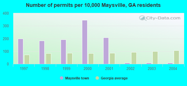
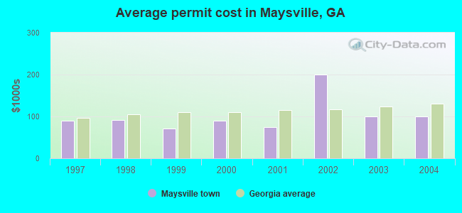
Single-family new house construction building permits:
- 2004: 1 building, cost: $100,000
- 2003: 1 building, cost: $100,000
- 2002: 1 building, cost: $200,000
- 2001: 26 buildings, average cost: $75,000
- 2000: 43 buildings, average cost: $90,000
- 1999: 24 buildings, average cost: $70,800
- 1998: 23 buildings, average cost: $92,200
- 1997: 25 buildings, average cost: $89,200
| Here: | 2.3% |
| Georgia: | 2.9% |

- Educational services (10.0%)
- Construction (6.6%)
- Health care (6.1%)
- Public administration (5.8%)
- Finance & insurance (5.6%)
- Administrative & support & waste management services (5.0%)
- Miscellaneous nondurable goods merchant wholesalers (4.1%)
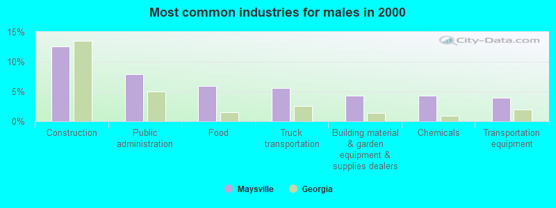
- Construction (12.6%)
- Public administration (7.9%)
- Food (6.0%)
- Truck transportation (5.6%)
- Building material & garden equipment & supplies dealers (4.3%)
- Chemicals (4.3%)
- Transportation equipment (4.0%)

- Educational services (16.9%)
- Health care (10.0%)
- Finance & insurance (7.6%)
- Administrative & support & waste management services (6.6%)
- Miscellaneous nondurable goods merchant wholesalers (6.3%)
- Furniture & home furnishings, household appliance stores (4.0%)
- Professional, scientific, technical services (3.7%)
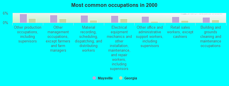
- Other production occupations, including supervisors (5.6%)
- Other management occupations, except farmers and farm managers (5.0%)
- Material recording, scheduling, dispatching, and distributing workers (4.8%)
- Electrical equipment mechanics and other installation, maintenance, and repair workers, including supervisors (4.5%)
- Other office and administrative support workers, including supervisors (4.0%)
- Retail sales workers, except cashiers (3.8%)
- Building and grounds cleaning and maintenance occupations (3.5%)
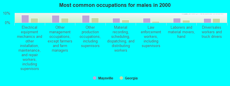
- Electrical equipment mechanics and other installation, maintenance, and repair workers, including supervisors (8.3%)
- Other management occupations, except farmers and farm managers (7.9%)
- Other production occupations, including supervisors (7.9%)
- Material recording, scheduling, dispatching, and distributing workers (5.0%)
- Law enforcement workers, including supervisors (5.0%)
- Laborers and material movers, hand (5.0%)
- Driver/sales workers and truck drivers (4.6%)
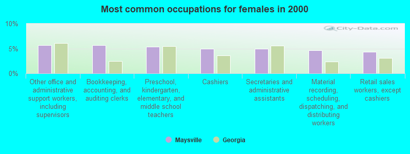
- Other office and administrative support workers, including supervisors (5.6%)
- Bookkeeping, accounting, and auditing clerks (5.6%)
- Preschool, kindergarten, elementary, and middle school teachers (5.3%)
- Cashiers (5.0%)
- Secretaries and administrative assistants (5.0%)
- Material recording, scheduling, dispatching, and distributing workers (4.7%)
- Retail sales workers, except cashiers (4.3%)
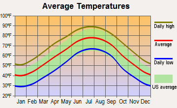
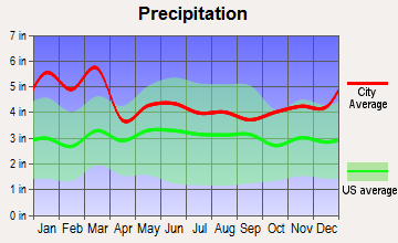
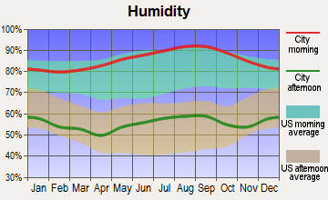
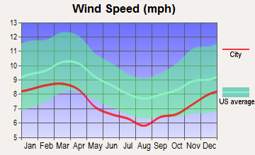
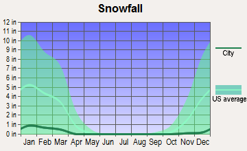
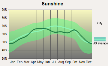
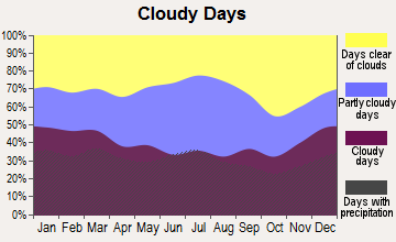
Average climate in Maysville, Georgia
Based on data reported by over 4,000 weather stations
(lower is better)

Air Quality Index (AQI) level in 2023 was 90.4. This is worse than average.
| City: | 90.4 |
| U.S.: | 72.6 |
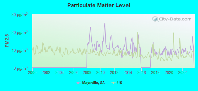
Particulate Matter (PM2.5) [µg/m3] level in 2023 was 11.5. This is significantly worse than average. Closest monitor was 14.9 miles away from the city center.
| City: | 11.5 |
| U.S.: | 8.1 |
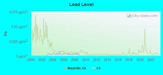
Lead (Pb) [µg/m3] level in 2008 was 0.00281. This is significantly better than average. Closest monitor was 14.9 miles away from the city center.
| City: | 0.00281 |
| U.S.: | 0.00931 |
Tornado activity:
Maysville-area historical tornado activity is near Georgia state average. It is 32% greater than the overall U.S. average.
On 12/13/1973, a category F3 (max. wind speeds 158-206 mph) tornado 8.7 miles away from the Maysville town center injured 21 people and caused between $500,000 and $5,000,000 in damages.
On 4/3/1974, a category F4 (max. wind speeds 207-260 mph) tornado 37.3 miles away from the town center killed 6 people and injured 30 people and caused between $500,000 and $5,000,000 in damages.
Earthquake activity:
Maysville-area historical earthquake activity is significantly above Georgia state average. It is 39% greater than the overall U.S. average.On 8/2/1974 at 08:52:09, a magnitude 4.9 (4.3 MB, 4.9 LG, Class: Light, Intensity: IV - V) earthquake occurred 66.8 miles away from Maysville center
On 4/29/2003 at 08:59:39, a magnitude 4.9 (4.4 MB, 4.6 MW, 4.9 LG) earthquake occurred 119.4 miles away from the city center
On 11/30/1973 at 07:48:41, a magnitude 4.7 (4.7 MB, 4.6 ML) earthquake occurred 109.2 miles away from the city center
On 8/9/2020 at 12:07:37, a magnitude 5.1 (5.1 MW, Depth: 4.7 mi, Class: Moderate, Intensity: VI - VII) earthquake occurred 207.1 miles away from Maysville center
On 4/29/2003 at 08:59:39, a magnitude 4.6 (4.6 MW, Depth: 12.3 mi) earthquake occurred 119.4 miles away from the city center
On 12/12/2018 at 09:14:43, a magnitude 4.4 (4.4 MW, Depth: 4.9 mi) earthquake occurred 115.1 miles away from the city center
Magnitude types: regional Lg-wave magnitude (LG), body-wave magnitude (MB), local magnitude (ML), moment magnitude (MW)
Natural disasters:
The number of natural disasters in Banks County (10) is smaller than the US average (15).Major Disasters (Presidential) Declared: 5
Emergencies Declared: 4
Causes of natural disasters: Winter Storms: 4, Hurricanes: 3, Drought: 1, Flood: 1, Snowfall: 1, Storm: 1, Other: 1 (Note: some incidents may be assigned to more than one category).
Hospitals and medical centers near Maysville:
- CRYSTLE SPRINGS NSG HOME, INC (Nursing Home, about 6 miles away; COMMERCE, GA)
- HILL HAVEN NURSING HOME (Nursing Home, about 6 miles away; COMMERCE, GA)
- BANKS-JACKSON-COMMERCE NC (Nursing Home, about 6 miles away; COMMERCE, GA)
- RESTORATION HEALTHCARE OF COMMERCE (Nursing Home, about 6 miles away; COMMERCE, GA)
- NORTHRIDGE MEDICAL CENTER Acute Care Hospitals (about 6 miles away; COMMERCE, GA)
- BELL MINOR HOME, THE (Nursing Home, about 14 miles away; GAINESVILLE, GA)
- LANIER PARK HOSPITAL (Hospital, about 15 miles away; GAINESVILLE, GA)
Colleges/universities with over 2000 students nearest to Maysville:
- Brenau University (about 16 miles; Gainesville, GA; Full-time enrollment: 2,341)
- Lanier Technical College (about 18 miles; Oakwood, GA; FT enrollment: 2,435)
- Piedmont College (about 22 miles; Demorest, GA; FT enrollment: 2,251)
- Athens Technical College (about 23 miles; Athens, GA; FT enrollment: 3,204)
- University of Georgia (about 24 miles; Athens, GA; FT enrollment: 32,679)
- University of North Georgia (about 31 miles; Dahlonega, GA; FT enrollment: 12,445)
- Georgia Gwinnett College (about 32 miles; Lawrenceville, GA; FT enrollment: 7,993)
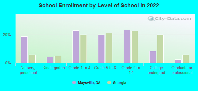
Public elementary/middle school in Maysville:
- MAYSVILLE ELEMENTARY SCHOOL (Students: 434, Location: 9270 HIGHWAY 82 SPUR, Grades: PK-5)
Points of interest:
Notable location: Maysville Area Volunteer Fire Department (A). Display/hide its location on the map
Cemetery: Sunrise Cemetery (1). Display/hide its location on the map
Reservoir: Reservoir 25 (A). Display/hide its location on the map
Park in Maysville: Maysville Historic District (1). Display/hide its location on the map
Tourist attraction: Bell Acres Resort (Recreation Areas; 158 Bell Acres Road).
Birthplace of: Tal Henry - Bandleader, William Turner Watkins - Methodist bishop.
| This town: | 2.7 people |
| Georgia: | 2.6 people |
| This town: | 73.7% |
| Whole state: | 68.5% |
| This town: | 4.0% |
| Whole state: | 5.9% |
Likely homosexual households (counted as self-reported same-sex unmarried-partner households)
- Lesbian couples: 0.3% of all households
- Gay men: 0.7% of all households
7 people in nursing homes in 2000
For population 15 years and over in Maysville:
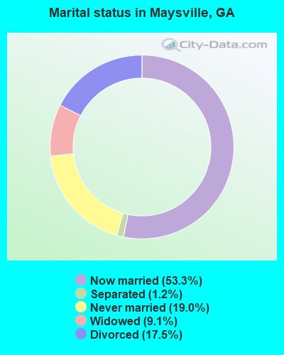
- Never married: 19.0%
- Now married: 53.3%
- Separated: 1.2%
- Widowed: 9.1%
- Divorced: 17.5%
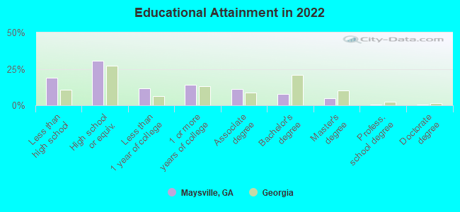
For population 25 years and over in Maysville:
- High school or higher: 79.0%
- Bachelor's degree or higher: 12.6%
- Graduate or professional degree: 5.1%
- Unemployed: 5.6%
- Mean travel time to work (commute): 29.3 minutes
| Here: | 12.5 |
| Georgia average: | 12.2 |
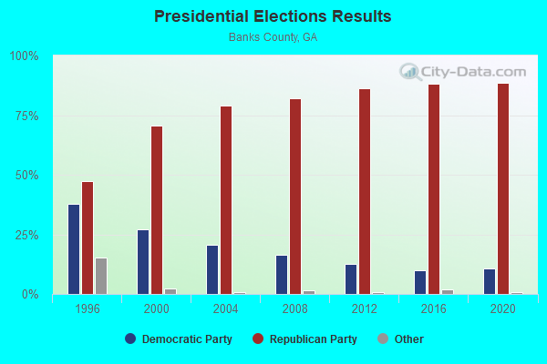
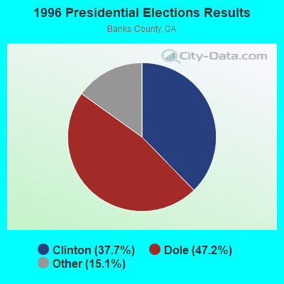
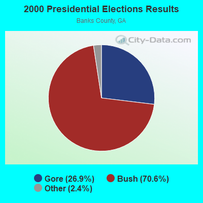

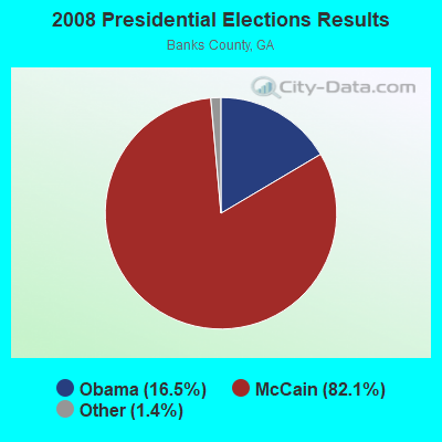


Graphs represent county-level data. Detailed 2008 Election Results
Religion statistics for Maysville, GA (based on Banks County data)
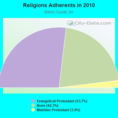
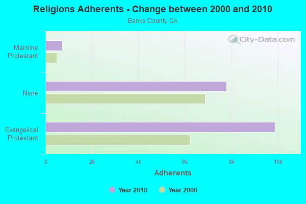
| Religion | Adherents | Congregations |
|---|---|---|
| Evangelical Protestant | 9,883 | 24 |
| Mainline Protestant | 726 | 5 |
| Other | 4 | 1 |
| None | 7,782 | - |
Food Environment Statistics:
| This county: | 0.61 / 10,000 pop. |
| Georgia: | 0.15 / 10,000 pop. |
| Here: | 5.45 / 10,000 pop. |
| Georgia: | 5.12 / 10,000 pop. |
| This county: | 10.90 / 10,000 pop. |
| Georgia: | 7.41 / 10,000 pop. |
| Banks County: | 10.3% |
| Georgia: | 10.4% |
| Here: | 29.1% |
| Georgia: | 27.8% |
| Banks County: | 15.3% |
| State: | 14.6% |
Health and Nutrition:
| Maysville: | 50.8% |
| Georgia: | 48.9% |
| Here: | 48.1% |
| State: | 46.5% |
| This city: | 28.0 |
| Georgia: | 28.9 |
| Here: | 22.7% |
| Georgia: | 20.4% |
| Here: | 8.3% |
| Georgia: | 10.8% |
| This city: | 6.9 |
| Georgia: | 6.7 |
| Maysville: | 32.5% |
| Georgia: | 33.5% |
| Here: | 57.6% |
| Georgia: | 56.2% |
| Maysville: | 79.3% |
| Georgia: | 80.8% |
More about Health and Nutrition of Maysville, GA Residents
| Local government employment and payroll (March 2022) | |||||
| Function | Full-time employees | Monthly full-time payroll | Average yearly full-time wage | Part-time employees | Monthly part-time payroll |
|---|---|---|---|---|---|
| Police Protection - Officers | 3 | $11,213 | $44,852 | 1 | $1,610 |
| Streets and Highways | 2 | $6,450 | $38,700 | 0 | $0 |
| Local Libraries | 1 | $2,270 | $27,240 | 1 | $547 |
| Other Government Administration | 1 | $4,745 | $56,940 | 0 | $0 |
| Financial Administration | 1 | $2,361 | $28,332 | 0 | $0 |
| Totals for Government | 8 | $27,039 | $40,559 | 2 | $2,157 |
Maysville government finances - Expenditure in 2017 (per resident):
- Current Operations - Central Staff Services: $201,000 ($97.67)
Police Protection: $171,000 ($83.09)
Solid Waste Management: $92,000 ($44.70)
Libraries: $47,000 ($22.84)
Regular Highways: $27,000 ($13.12)
- General - Interest on Debt: $48,000 ($23.32)
Maysville government finances - Revenue in 2017 (per resident):
- Charges - Sewerage: $324,000 ($157.43)
Solid Waste Management: $112,000 ($54.42)
- Local Intergovernmental - General Local Government Support: $432,000 ($209.91)
- Miscellaneous - Fines and Forfeits: $48,000 ($23.32)
Donations From Private Sources: $8,000 ($3.89)
General Revenue - Other: $5,000 ($2.43)
- Revenue - Water Utilities: $331,000 ($160.84)
- State Intergovernmental - Other: $21,000 ($10.20)
- Tax - Insurance Premiums Sales: $113,000 ($54.91)
Public Utilities Sales: $93,000 ($45.19)
Property: $66,000 ($32.07)
Occupation and Business License - Other: $8,000 ($3.89)
Other License: $1,000 ($0.49)
Maysville government finances - Debt in 2017 (per resident):
- Long Term Debt - Beginning Outstanding - Unspecified Public Purpose: $1,228,000 ($596.70)
Outstanding Unspecified Public Purpose: $1,156,000 ($561.71)
Retired Unspecified Public Purpose: $72,000 ($34.99)
Maysville government finances - Cash and Securities in 2017 (per resident):
- Bond Funds - Cash and Securities: $269,000 ($130.71)
- Other Funds - Cash and Securities: $1,549,000 ($752.67)
Businesses in Maysville, GA
- U-Haul: 1
Strongest AM radio stations in Maysville:
- WDUN (550 AM; 10 kW; GAINESVILLE, GA; Owner: JWJ PROPERTIRS, INC.)
- WJJC (1270 AM; 5 kW; COMMERCE, GA; Owner: BANKS-JACKSON BROADCASTING)
- WLBA (1130 AM; daytime; 10 kW; GAINESVILLE, GA)
- WCNN (680 AM; 50 kW; NORTH ATLANTA, GA; Owner: DICKEY BROADCASTING COMPANY)
- WSB (750 AM; 50 kW; ATLANTA, GA; Owner: CXR HOLDINGS, INC.)
- WGST (640 AM; 50 kW; ATLANTA, GA; Owner: CITICASTERS LICENSES, L.P.)
- WBKZ (880 AM; daytime; 5 kW; JEFFERSON, GA; Owner: BROWN BROADCASTING SYSTEM, INC.)
- WGUN (1010 AM; 50 kW; ATLANTA, GA; Owner: WGUN, INC.)
- WRFC (960 AM; 5 kW; ATHENS, GA; Owner: SOUTHERN BROADCASTING OF ATHENS, INC)
- WLFJ (660 AM; daytime; 50 kW; GREENVILLE, SC; Owner: CLEAR CHANNEL BROADCASTING LICENSES, INC.)
- WQXI (790 AM; 28 kW; ATLANTA, GA; Owner: JEFFERSON-PILOT COMMUNICATIONS COMPANY OF GEORGIA)
- WFTD (1080 AM; daytime; 50 kW; MARIETTA, GA; Owner: PRIETO ENTERPRISES, INC.)
- WMLB (1160 AM; 50 kW; EAST POINT, GA; Owner: ATLANTA AREA BROADCASTING, INC.)
Strongest FM radio stations in Maysville:
- WNGC (106.1 FM; TOCCOA, GA; Owner: SOUTHERN BROADCASTING OF PENSACOLA, INC)
- WBTS (95.5 FM; ATHENS, GA; Owner: CXR HOLDINGS, INC.)
- WFOX (97.1 FM; GAINESVILLE, GA; Owner: COX RADIO, INC.)
- WYAY (106.7 FM; GAINESVILLE, GA; Owner: ABC, INC.)
- WFSH-FM (104.7 FM; ATHENS, GA; Owner: SOUTH TEXAS BROADCASTING, INC.)
- WCON-FM (99.3 FM; CORNELIA, GA; Owner: HABERSHAM BROADCASTING CO.)
- WBCX (89.1 FM; GAINESVILLE, GA; Owner: BRENAU COLLEGE)
- WPPR (88.3 FM; DEMOREST, GA; Owner: GEORGIA PUBLIC TELECOMMUNICATIONS COMMISSION)
- WFQS (91.3 FM; FRANKLIN, NC; Owner: WESTERN NORTH CAROLINA PUBLIC RADIO)
- WWEV-FM (91.5 FM; CUMMING, GA; Owner: CURRICULUM DEVELOPMENT FOUNDATION)
- WRBN (104.1 FM; CLAYTON, GA; Owner: SUTTON RADIOCASTING CORPORATION)
- WPUP (103.7 FM; ROYSTON, GA; Owner: SOUTHERN BROADCASTING OF ATHENS, INC.)
- WAZX-FM (101.9 FM; CLEVELAND, GA; Owner: WAZX-FM, INC)
- WRAF (90.9 FM; TOCCOA FALLS, GA; Owner: TOCCOA FALLS COLLEGE)
- WMJE (102.9 FM; CLARKESVILLE, GA; Owner: JWJ PROPERTIES, INC.)
- WHZT (98.1 FM; SENECA, SC; Owner: CXR HOLDINGS, INC.)
- WHEL (105.1 FM; HELEN, GA; Owner: CITICASTERS LICENSES, L.P.)
- WLKQ-FM (102.3 FM; BUFORD, GA; Owner: LAKE RADIO, INC.)
- WMSL (88.9 FM; ATHENS, GA; Owner: PRINCE AVENUE BAPTIST CHRISTIAN SCHOOL)
TV broadcast stations around Maysville:
- W50AB (Channel 50; HIAWASSEE, GA; Owner: GEORGIA PUBLIC TELECOMMUNICATIONS COMMISSION)
- W22AC (Channel 22; HARTWELL & ROYSTON, GA; Owner: GEORGIA PUBLIC TELECOMMUNICATIONS COMMISSION)
- WUVG (Channel 34; ATHENS, GA; Owner: UNIVISION ATLANTA LLC)
- WNEG-TV (Channel 32; TOCCOA, GA; Owner: MEDIA GENERAL BROADCASTING OF SO. CAROLINA HOLDINGS, INC.)
- W42AO (Channel 42; ATHENS, GA; Owner: GEORGIA REGIONAL COMMUNITY TV)
Maysville fatal accident list:
Jul 4, 2011 07:47 AM, Sr-51, Lat: 34.347494, Lon: -83.574328, Vehicles: 1, Persons: 1, Fatalities: 1
Mar 4, 2010 05:58 PM, Sr-98, Lat: 34.260889, Lon: -83.559672, Vehicles: 1, Persons: 1, Pedestrians: 1, Fatalities: 1
May 20, 1998 11:25 AM, Us-Sr98, Vehicles: 1, Persons: 2, Pedestrians: 1, Fatalities: 1
- National Bridge Inventory (NBI) Statistics
- 11Number of bridges
- 105ft / 31.6mTotal length
- $22,701,000Total costs
- 6,238Total average daily traffic
- 181Total average daily truck traffic
- 9,882Total future (year 2031) average daily traffic
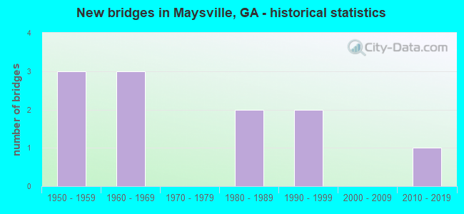
- New bridges - historical statistics
- 31950-1959
- 31960-1969
- 21980-1989
- 21990-1999
- 12010-2019
FCC Registered Antenna Towers:
59 (See the full list of FCC Registered Antenna Towers in Maysville)FCC Registered Broadcast Land Mobile Towers:
3- Lat: 33.259583 Lon: -83.560444, Call Sign: WQBD857,
Assigned Frequencies: 457.537 MHz, 457.562 MHz, 457.587 MHz, 467.762 MHz, 467.787 MHz, 467.812 MHz, 467.837 MHz, 467.862 MHz, 467.887 MHz, 467.912 MHz, Grant Date: 09/30/2014, Expiration Date: 09/24/2024, Certifier: Guy S Hinton, Registrant: Wayne Farms LLC, 825 Twin Mill Dr., Maysville, GA 30558, Phone: (706) 693-1270, Email:
- Lat: 34.238833 Lon: -83.550556, Call Sign: WQIH289,
Assigned Frequencies: 456.550 MHz, Grant Date: 02/11/2008, Expiration Date: 02/11/2018, Cancellation Date: 04/14/2018, Certifier: Jerry Baker, Registrant: Cara Enterprises, Inc., Salt Lake City, UT 84117-0503, Phone: (801) 278-9728, Fax: (801) 278-7239, Email:
- Plainview, 4345 Plainview Road (Lat: 34.218389 Lon: -83.629028), Type: Ltower, Structure height: 91.4 m, Overall height: 100.6 m, Call Sign: WRQA428, Licensee ID: L00013671,
Assigned Frequencies: 854.112 MHz, 854.187 MHz, 856.162 MHz, 857.037 MHz, 854.575 MHz, 856.200 MHz, 856.400 MHz, 856.675 MHz, 857.200 MHz, Grant Date: 04/12/2022, Expiration Date: 04/12/2032, Certifier: Bryan Bullock, Registrant: Jackson County Emergency Services, 368 Curtis H. Spence Drive, Jefferson, GA 30549, Phone: (706) 612-0185, Fax: (706) 387-6427, Email:
FCC Registered Microwave Towers:
5- MAYSVILLE WT, 221 Industrial Dr. (Lat: 34.238806 Lon: -83.550583), Type: Tank, Structure height: 50.3 m, Call Sign: WQNH316,
Assigned Frequencies: 10855.0 MHz, 10735.0 MHz, 10855.0 MHz, 10735.0 MHz, 10855.0 MHz, 10735.0 MHz, Grant Date: 02/01/2021, Expiration Date: 02/04/2031, Certifier: Steve Nichols, Registrant: Jackson County Emergency Services, 368 Curtis H. Spence Dr., Jefferson, GA 30549, Phone: (706) 612-0185, Fax: (706) 387-6427, Email:
- AT72XC125, In City (Lat: 34.222639 Lon: -83.533583), Type: Ltower, Structure height: 76.2 m, Overall height: 80.7 m, Call Sign: WQQY979,
Assigned Frequencies: 10775.0 MHz, 10895.0 MHz, 18015.0 MHz, 10775.0 MHz, 10895.0 MHz, 18015.0 MHz, 10775.0 MHz, 10895.0 MHz, 18015.0 MHz, 10775.0 MHz... (+8 more), Grant Date: 03/28/2013, Expiration Date: 03/28/2023, Cancellation Date: 03/27/2023, Certifier: Jenny Knopf, Registrant: T-Mobile Usa, Inc., 12920 Se 38th St, Bellevue, WA 98006, Phone: (425) 383-8401, Fax: (425) 383-4840, Email:
- 9AT3946A, In City (Lat: 34.222639 Lon: -83.533583), Type: Ltower, Structure height: 76.2 m, Overall height: 80.7 m, Call Sign: WQVC900,
Assigned Frequencies: 10855.0 MHz, 10855.0 MHz, 10855.0 MHz, 10855.0 MHz, 10855.0 MHz, 10855.0 MHz, 10855.0 MHz, 10855.0 MHz, 10855.0 MHz, 10855.0 MHz... (+22 more), Grant Date: 01/06/2015, Expiration Date: 01/06/2025, Certifier: David Werblow, Registrant: T-Mobile Usa, Inc., 12920 Se 38th Street, Bellevue, WA 98006, Phone: (425) 383-8401, Fax: (425) 383-4040, Email:
- MAYSVILLE, 40 School Way (Lat: 34.245694 Lon: -83.558056), Type: Ltower, Structure height: 91.4 m, Overall height: 100.6 m, Call Sign: WRPW819,
Assigned Frequencies: 6137.92 MHz, 5960.02 MHz, 6019.32 MHz, 6137.92 MHz, 5960.02 MHz, 6019.32 MHz, 6137.92 MHz, 5960.02 MHz, 6019.32 MHz, 6137.92 MHz... (+17 more), Grant Date: 03/28/2022, Expiration Date: 03/28/2032, Certifier: Bryan Bullock, Registrant: Jackson County Emergency Services, 368 Curtis H Spence Drive, Jefferson, GA 30549, Phone: (706) 367-1233, Email:
- PLAINVIEW, 4345 Plainview Road (Lat: 34.218389 Lon: -83.629028), Type: Ltower, Structure height: 91.4 m, Overall height: 100.6 m, Call Sign: WRPW871,
Assigned Frequencies: 6271.36 MHz, 6330.66 MHz, 6375.14 MHz, 6212.06 MHz, 6271.36 MHz, 6212.06 MHz, 6271.36 MHz, 6271.36 MHz, 6330.66 MHz, 6212.06 MHz... (+45 more), Grant Date: 03/28/2022, Expiration Date: 03/28/2032, Certifier: Bryan Bullock, Registrant: Jackson County Emergency Services, 368 Curtis H Spence Drive, Jefferson, GA 30549, Phone: (706) 367-1233, Email:
FCC Registered Amateur Radio Licenses:
25 (See the full list of FCC Registered Amateur Radio Licenses in Maysville)FAA Registered Aircraft:
2- Aircraft: PIPER J3C-65 (Category: Land, Seats: 2, Weight: Up to 12,499 Pounds, Speed: 67 mph), Engine: CONT MOTOR A&C65 SERIES (65 HP) (Reciprocating)
N-Number: 7366H, N7366H, N-7366H, Serial Number: 20625, Year manufactured: 1946, Airworthiness Date: 12/05/1955, Certificate Issue Date: 08/11/2020
Registrant (Individual): Bethany M Mccoy, 845 Welborn Rd, Maysville, GA 30558 - Aircraft: CESSNA 421B (Category: Land, Engines: 2, Seats: 8, Weight: Up to 12,499 Pounds, Speed: 172 mph), Engine: CONT MOTOR GTSIO-520-C (340 HP) (Reciprocating)
N-Number: 13HB, N13HB, N-13HB, Serial Number: 421B0582, Year manufactured: 1974, Airworthiness Date: 02/25/1974, Certificate Issue Date: 05/12/2015
Registrant (Corporation): Ridgeback Farm LLC, 415 Parson Cir, Maysville, GA 30558
2002 - 2018 National Fire Incident Reporting System (NFIRS) incidents
- Fire incident types reported to NFIRS in Maysville, GA
- 10751.0%Structure Fires
- 6932.9%Outside Fires
- 2712.9%Mobile Property/Vehicle Fires
- 73.3%Other
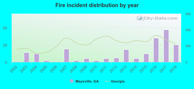 According to the data from the years 2002 - 2018 the average number of fire incidents per year is 12. The highest number of fire incidents - 47 took place in 2017, and the least - 0 in 2006. The data has a growing trend.
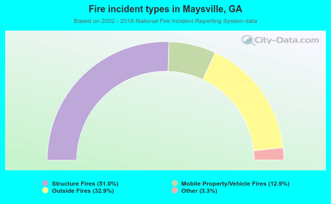 When looking into fire subcategories, the most incidents belonged to: Structure Fires (51.0%), and Outside Fires (32.9%).
| Most common first names in Maysville, GA among deceased individuals | ||
| Name | Count | Lived (average) |
|---|---|---|
| James | 36 | 67.6 years |
| William | 26 | 69.7 years |
| Mary | 24 | 77.0 years |
| John | 18 | 71.4 years |
| Robert | 18 | 73.2 years |
| George | 13 | 75.2 years |
| Eugene | 11 | 69.7 years |
| Richard | 9 | 68.8 years |
| Charlie | 8 | 70.3 years |
| David | 7 | 61.6 years |
| Most common last names in Maysville, GA among deceased individuals | ||
| Last name | Count | Lived (average) |
|---|---|---|
| Hill | 18 | 73.3 years |
| Smith | 17 | 72.2 years |
| Cochran | 12 | 71.0 years |
| Crane | 11 | 70.0 years |
| Parson | 11 | 71.9 years |
| Morris | 11 | 79.5 years |
| Brown | 11 | 67.7 years |
| Jones | 9 | 54.2 years |
| Mcclure | 9 | 70.0 years |
| Griffin | 9 | 75.7 years |
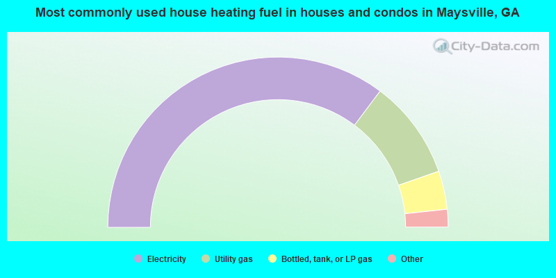
- 70.7%Electricity
- 18.9%Utility gas
- 7.3%Bottled, tank, or LP gas
- 2.1%Wood
- 1.0%No fuel used
- 57.8%Electricity
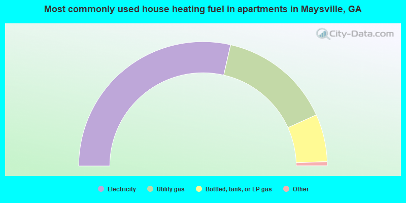
- 29.7%Utility gas
- 12.5%Bottled, tank, or LP gas
Maysville compared to Georgia state average:
- Unemployed percentage below state average.
- Black race population percentage significantly below state average.
- Foreign-born population percentage below state average.
- Renting percentage below state average.
- Length of stay since moving in significantly above state average.
- Number of college students below state average.
- Percentage of population with a bachelor's degree or higher below state average.

|
|
Total of 31 patent applications in 2008-2024.