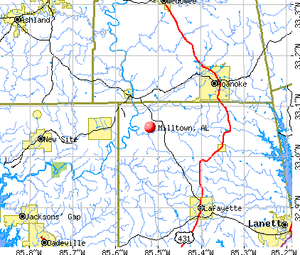
Milltown, Alabama
Submit your own pictures of this place and show them to the world
- OSM Map
- General Map
- Google Map
- MSN Map
| Males: 510 | |
| Females: 533 |
| Median resident age: | 40.1 years |
| Alabama median age: | 35.8 years |
Zip code: 36862
| Milltown: | $47,190 |
| AL: | $59,674 |
Estimated per capita income in 2022: $29,137 (it was $16,133 in 2000)
Milltown CCD income, earnings, and wages data
Estimated median house or condo value in 2022: $189,092 (it was $81,900 in 2000)
| Milltown: | $189,092 |
| AL: | $200,900 |
Detailed information about poverty and poor residents in Milltown, AL
Compare current foreclosures near Milltown, AL:
| Photo | Address | Area | Beds / Baths | Price | Details |
|---|---|---|---|---|---|

|
#1
County Road 268
Five Points, AL 36855
|
1,236 sq. feet
|
2 baths 3 beds |
$224,500
|
show details |

|
#2
Yeargan Dr
Lafayette, AL 36862
|
1 sq. feet
|
1 baths 2 beds |
show details | |

|
#3
County Road 79
Roanoke, AL 36274
|
2,282 sq. feet
|
1 baths 3 beds |
show details | |

|
#4
County Road 53
Wadley, AL 36276
|
- sq. feet
|
- baths - beds |
show details | |

|
#5
2nd Ave SW
Lafayette, AL 36862
|
1,731 sq. feet
|
- baths - beds |
show details | |

|
#6
5th Cir SW
Lafayette, AL 36862
|
- sq. feet
|
- baths - beds |
show details | |

|
#7
3rd St NE
Lafayette, AL 36862
|
1,078 sq. feet
|
- baths - beds |
show details | |

|
#8
Hilltop Apts Apt A
Lafayette, AL 36862
|
- sq. feet
|
- baths - beds |
show details | |

|
#9
County Road 527
Lafayette, AL 36862
|
- sq. feet
|
- baths - beds |
show details | |

|
#10
County Road 262
Five Points, AL 36855
|
1,496 sq. feet
|
- baths - beds |
show details |
| Photo | Address | Area | Beds / Baths | Price | Details |
|---|---|---|---|---|---|

|
#11
Overton Mountain Dr
Roanoke, AL 36274
|
912 sq. feet
|
- baths - beds |
show details | |

|
#12
County Road 33
Wedowee, AL 36278
|
- sq. feet
|
- baths - beds |
show details | |

|
#13
A Jenkins Apartments
Lafayette, AL 36862
|
- sq. feet
|
- baths - beds |
show details | |

|
#14
County Road 33
Wedowee, AL 36278
|
- sq. feet
|
- baths - beds |
show details | |

|
#15
County Road 69
Lafayette, AL 36862
|
- sq. feet
|
- baths - beds |
show details | |

|
#16
Alabama Ave E
Lafayette, AL 36862
|
1,170 sq. feet
|
- baths - beds |
show details | |

|
#17
Alabama Ave E
Lafayette, AL 36862
|
- sq. feet
|
- baths - beds |
show details | |

|
#18
7th St NE
Lafayette, AL 36862
|
- sq. feet
|
- baths - beds |
show details | |

|
#19
County Road 667
Roanoke, AL 36274
|
1,056 sq. feet
|
- baths - beds |
show details | |

|
#20
County Road 28
Lafayette, AL 36862
|
1,736 sq. feet
|
- baths - beds |
show details |
| Photo | Address | Area | Beds / Baths | Price | Details |
|---|---|---|---|---|---|

|
#21
4th Pl NE
Lafayette, AL 36862
|
1,680 sq. feet
|
- baths - beds |
show details | |

|
#22
Dudleyville Rd
Dadeville, AL 36853
|
- sq. feet
|
- baths - beds |
show details | |

|
#23
2nd Ave SW
Lafayette, AL 36862
|
2,240 sq. feet
|
- baths - beds |
show details | |

|
#24
2nd Ave NE
Lafayette, AL 36862
|
- sq. feet
|
- baths - beds |
show details | |

|
#25
County Road 491
Lafayette, AL 36862
|
- sq. feet
|
- baths - beds |
show details | |

|
#26
County Road 222
Five Points, AL 36855
|
1,508 sq. feet
|
- baths - beds |
show details | |

|
#27
County Road 79 Apt 205
Roanoke, AL 36274
|
- sq. feet
|
- baths - beds |
show details | |

|
#28
County Road 149
Roanoke, AL 36274
|
- sq. feet
|
- baths - beds |
show details | |

|
#29
Pine Valley Dr
Roanoke, AL 36274
|
984 sq. feet
|
- baths - beds |
show details | |

|
#30
Pine Valley Dr
Roanoke, AL 36274
|
1,116 sq. feet
|
- baths - beds |
show details |
| Photo | Address | Area | Beds / Baths | Price | Details |
|---|---|---|---|---|---|

|
#31
County Road 79
Roanoke, AL 36274
|
1,222 sq. feet
|
- baths - beds |
show details | |

|
#32
Parris Cir
Roanoke, AL 36274
|
- sq. feet
|
- baths - beds |
show details | |

|
#33
Cauthen Cir
Roanoke, AL 36274
|
2,664 sq. feet
|
- baths - beds |
show details | |

|
#34
Us Highway 431
Lafayette, AL 36862
|
1,292 sq. feet
|
- baths - beds |
show details | |

|
#35
Omaha Rd
Roanoke, AL 36274
|
- sq. feet
|
- baths - beds |
show details | |

|
#36
Al Highway 77 N Apt C
Lafayette, AL 36862
|
- sq. feet
|
- baths - beds |
show details | |

|
#37
County Road 18
Roanoke, AL 36274
|
- sq. feet
|
- baths - beds |
show details | |

|
#38
Carver Dr
Lafayette, AL 36862
|
- sq. feet
|
- baths - beds |
show details | |

|
#39
County Road 5
Lineville, AL 36266
|
- sq. feet
|
- baths - beds |
show details | |

|
#40
Highway 22
Roanoke, AL 36274
|
1,672 sq. feet
|
- baths - beds |
show details |
| Photo | Address | Area | Beds / Baths | Price | Details |
|---|---|---|---|---|---|

|
#41
S Lafayette St
Lafayette, AL 36862
|
1,904 sq. feet
|
- baths - beds |
show details | |

|
#42
7th St SW
Lafayette, AL 36862
|
- sq. feet
|
- baths - beds |
show details | |

|
#43
Alabama Ave W # B
Lafayette, AL 36862
|
- sq. feet
|
- baths - beds |
show details | |

|
#44
Pinecrest Dr
Lafayette, AL 36862
|
1,200 sq. feet
|
- baths - beds |
show details | |

|
#45
S Lafayette St
Lafayette, AL 36862
|
- sq. feet
|
- baths - beds |
show details | |

|
#46
4th Pl SE
Lafayette, AL 36862
|
- sq. feet
|
- baths - beds |
show details | |

|
#47
Alabama Ave E
Lafayette, AL 36862
|
- sq. feet
|
- baths - beds |
show details | |

|
#48
6th Pl SE
Lafayette, AL 36862
|
- sq. feet
|
- baths - beds |
show details | |

|
#49
County Road 59
Roanoke, AL 36274
|
- sq. feet
|
- baths - beds |
show details | |

|
Check over 1 million property listings on Foreclosure.com!
|
browse all offers | |||

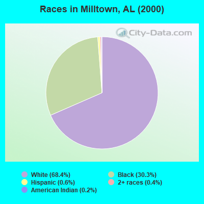
- 75268.4%White alone
- 33330.3%Black alone
- 70.6%Hispanic
- 40.4%Two or more races
- 20.2%American Indian alone
- 10.09%Asian alone
 Recent articles from our blog. Our writers, many of them Ph.D. graduates or candidates, create easy-to-read articles on a wide variety of topics.

Current Local Time: CST time zone
Elevation: 655 feet
Land area: 80.1 square miles.
Population density: 13 people per square mile (very low).

| Milltown CCD: | 0.2% ($199) |
| Alabama: | 0.4% ($289) |
Nearest city with pop. 50,000+: Columbus, GA  (51.8 miles , pop. 185,781).
Nearest city with pop. 200,000+: Montgomery, AL (65.4 miles , pop. 201,568).
Nearest city with pop. 1,000,000+: Chicago, IL (618.9 miles , pop. 2,896,016).
Nearest cities:
), ), ), ), )Latitude: 33.06 N, Longitude: 85.52 W


| Here: | 2.7% |
| Alabama: | 2.6% |
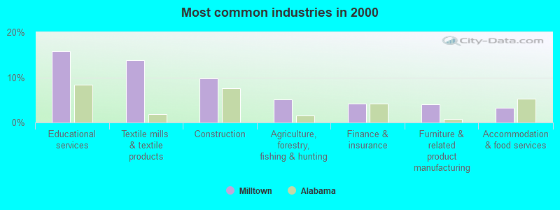
- Educational services (15.8%)
- Textile mills & textile products (13.8%)
- Construction (9.8%)
- Agriculture, forestry, fishing & hunting (5.2%)
- Finance & insurance (4.2%)
- Furniture & related product manufacturing (4.0%)
- Accommodation & food services (3.2%)
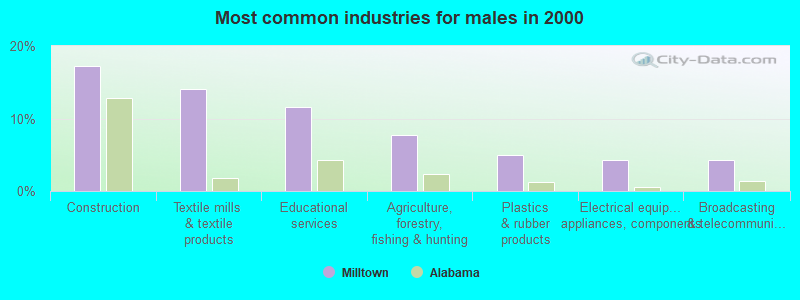
- Construction (17.3%)
- Textile mills & textile products (14.1%)
- Educational services (11.6%)
- Agriculture, forestry, fishing & hunting (7.7%)
- Plastics & rubber products (4.9%)
- Electrical equipment, appliances, components (4.2%)
- Broadcasting & telecommunications (4.2%)

- Educational services (21.2%)
- Textile mills & textile products (13.4%)
- Finance & insurance (7.4%)
- Social assistance (6.9%)
- Furniture & related product manufacturing (6.0%)
- Health care (5.5%)
- Transportation equipment (3.7%)
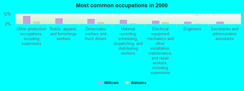
- Other production occupations, including supervisors (10.2%)
- Textile, apparel, and furnishings workers (7.4%)
- Driver/sales workers and truck drivers (6.6%)
- Material recording, scheduling, dispatching, and distributing workers (5.6%)
- Electrical equipment mechanics and other installation, maintenance, and repair workers, including supervisors (4.2%)
- Engineers (3.4%)
- Secretaries and administrative assistants (3.2%)

- Other production occupations, including supervisors (10.6%)
- Material recording, scheduling, dispatching, and distributing workers (9.9%)
- Driver/sales workers and truck drivers (9.5%)
- Electrical equipment mechanics and other installation, maintenance, and repair workers, including supervisors (7.4%)
- Textile, apparel, and furnishings workers (6.3%)
- Engineers (6.0%)
- Supervisors, construction and extraction workers (5.3%)

- Other production occupations, including supervisors (9.7%)
- Textile, apparel, and furnishings workers (8.8%)
- Secretaries and administrative assistants (7.4%)
- Child care workers (6.9%)
- Metal workers and plastic workers (6.5%)
- Nursing, psychiatric, and home health aides (6.0%)
- Building and grounds cleaning and maintenance occupations (5.1%)
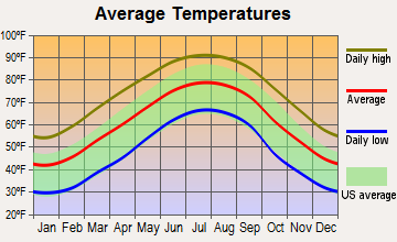
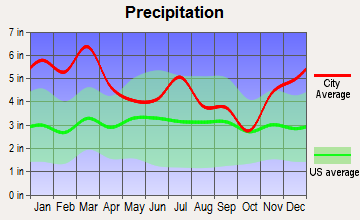
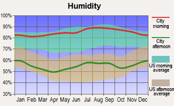
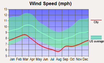
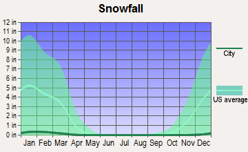
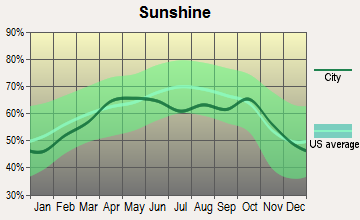
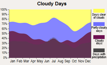
Average climate in Milltown, Alabama
Based on data reported by over 4,000 weather stations
Tornado activity:
Milltown-area historical tornado activity is slightly below Alabama state average. It is 66% greater than the overall U.S. average.
On 5/1/1953, a category F4 (max. wind speeds 207-260 mph) tornado 21.4 miles away from the Milltown place center killed 7 people and injured 12 people and caused between $50,000 and $500,000 in damages.
On 1/26/1974, a category F3 (max. wind speeds 158-206 mph) tornado 5.7 miles away from the place center killed one person and injured 7 people and caused between $50,000 and $500,000 in damages.
Earthquake activity:
Milltown-area historical earthquake activity is significantly above Alabama state average. It is 67% greater than the overall U.S. average.On 4/29/2003 at 08:59:39, a magnitude 4.9 (4.4 MB, 4.6 MW, 4.9 LG, Class: Light, Intensity: IV - V) earthquake occurred 99.5 miles away from Milltown center
On 1/18/1999 at 07:00:53, a magnitude 4.8 (4.8 MB, 4.0 LG, Depth: 0.6 mi) earthquake occurred 103.2 miles away from Milltown center
On 4/29/2003 at 08:59:39, a magnitude 4.6 (4.6 MW, Depth: 12.3 mi) earthquake occurred 99.5 miles away from the city center
On 10/24/1997 at 08:35:17, a magnitude 4.9 (4.8 MB, 4.2 MS, 4.9 LG, Depth: 6.2 mi) earthquake occurred 168.7 miles away from Milltown center
On 8/2/1974 at 08:52:09, a magnitude 4.9 (4.3 MB, 4.9 LG) earthquake occurred 183.7 miles away from the city center
On 6/24/1975 at 11:11:36, a magnitude 4.5 (4.5 MB) earthquake occurred 141.6 miles away from Milltown center
Magnitude types: regional Lg-wave magnitude (LG), body-wave magnitude (MB), surface-wave magnitude (MS), moment magnitude (MW)
Natural disasters:
The number of natural disasters in Chambers County (17) is near the US average (15).Major Disasters (Presidential) Declared: 10
Emergencies Declared: 5
Causes of natural disasters: Floods: 8, Storms: 8, Tornadoes: 7, Hurricanes: 5, Winds: 4, Drought: 1, Heavy Rain: 1, Snowfall: 1, Winter Storm: 1, Other: 1 (Note: some incidents may be assigned to more than one category).
Hospitals and medical centers near Milltown:
- ROANOKE HEALTH CARE CENTER, LLC (Nursing Home, about 10 miles away; ROANOKE, AL)
- FAITH HOME CARE, INC (Hospital, about 11 miles away; ROANOKE, AL)
- RANDOLPH COUNTY HOME CARE (Home Health Center, about 12 miles away; ROANOKE, AL)
- LAFAYETTE NURSING HOME (Nursing Home, about 14 miles away; LAFAYETTE, AL)
- FMC CHAMBERS (Dialysis Facility, about 14 miles away; LAFAYETTE, AL)
- LAFAYETTE EXTENDED CARE (Nursing Home, about 14 miles away; LAFAYETTE, AL)
Colleges/universities with over 2000 students nearest to Milltown:
- Southern Union State Community College (about 6 miles; Wadley, AL; Full-time enrollment: 4,120)
- Auburn University (about 32 miles; Auburn University, AL; FT enrollment: 22,741)
- University of West Georgia (about 44 miles; Carrollton, GA; FT enrollment: 10,358)
- Tuskegee University (about 45 miles; Tuskegee, AL; FT enrollment: 2,810)
- West Georgia Technical College (about 48 miles; Waco, GA; FT enrollment: 4,768)
- Columbus Technical College (about 50 miles; Columbus, GA; FT enrollment: 3,241)
- Columbus State University (about 52 miles; Columbus, GA; FT enrollment: 6,876)
Points of interest:
Notable locations in Milltown: Sparkling Springs (A), Penton Raceway (B), Abanda Fire and Rescue (C), Union Hill Volunteer Fire Department (D). Display/hide their locations on the map
Churches in Milltown include: Mount Hickory Church (A), Mount Zion Church (B), Mountain Spring Church (C), New Hope Church (D), New Harmony Church (E), Shiloh Baptist Church (F), Abanda Baptist Church (G), The Greater Pine Hill Church (H), Penton Church (I). Display/hide their locations on the map
Cemeteries: Sims Cemetery (1), Milltown Cemetery (2), Tatum Cemetery (3), Ebenezer Cemetery (4), Beulah Cemetery (5), Bailey Cemetery (6), Abanda Cemetery (7). Display/hide their locations on the map
Reservoirs: Welch Lake (A), Slaughter Lake (B), Edge Lake (C), Allens Lake (D). Display/hide their locations on the map
Streams, rivers, and creeks: Sandy Creek (A), Chikasanoxee Creek (B), Rocky Branch (C), Pigeonroost Creek (D), Mathews Branch (E), Laney Creek (F), High Pine Creek (G), Caty Creek (H), Carlisle Creek (I). Display/hide their locations on the map
| This place: | 2.5 people |
| Alabama: | 2.5 people |
| This place: | 69.0% |
| Whole state: | 67.8% |
| This place: | 6.0% |
| Whole state: | 4.7% |
Likely homosexual households (counted as self-reported same-sex unmarried-partner households)
- Lesbian couples: 0.2% of all households
- Gay men: 0.7% of all households
| This place: | 19.2% |
| Whole state: | 16.1% |
| This place: | 7.8% |
| Whole state: | 7.3% |
For population 15 years and over in Milltown:
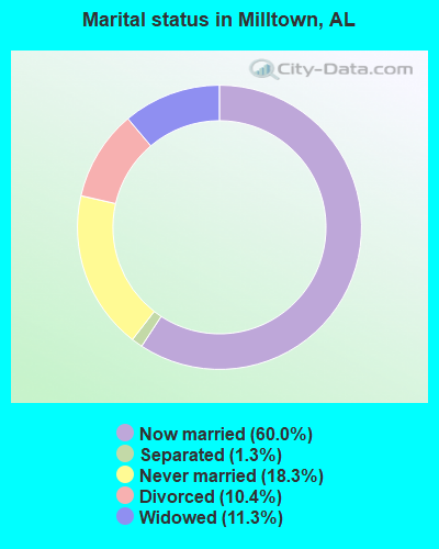
- Never married: 18.3%
- Now married: 60.0%
- Separated: 1.3%
- Widowed: 11.3%
- Divorced: 10.4%
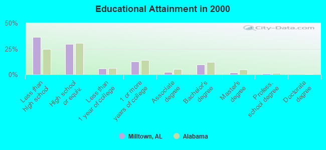
For population 25 years and over in Milltown:
- High school or higher: 63.6%
- Bachelor's degree or higher: 12.7%
- Graduate or professional degree: 2.9%
- Unemployed: 4.8%
- Mean travel time to work (commute): 26.3 minutes
| Here: | 12.0 |
| Alabama average: | 13.2 |
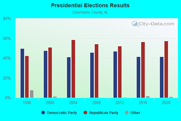
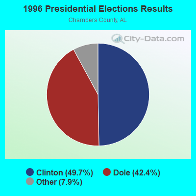
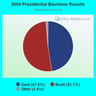

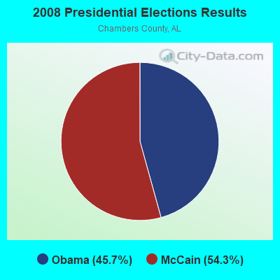
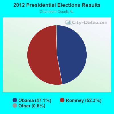
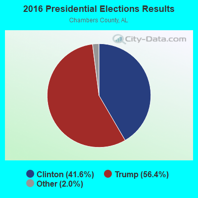

Graphs represent county-level data. Detailed 2008 Election Results
Religion statistics for Milltown, AL (based on Chambers County data)
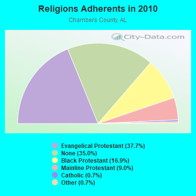
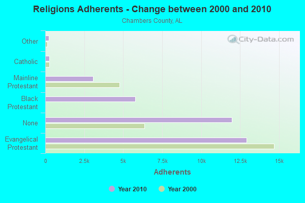
| Religion | Adherents | Congregations |
|---|---|---|
| Evangelical Protestant | 12,903 | 62 |
| Black Protestant | 5,780 | 21 |
| Mainline Protestant | 3,080 | 33 |
| Catholic | 249 | 1 |
| Other | 239 | 2 |
| None | 11,964 | - |
Food Environment Statistics:
| Chambers County: | 2.02 / 10,000 pop. |
| State: | 1.89 / 10,000 pop. |
| This county: | 0.29 / 10,000 pop. |
| Alabama: | 0.20 / 10,000 pop. |
| Chambers County: | 1.15 / 10,000 pop. |
| Alabama: | 0.65 / 10,000 pop. |
| Here: | 6.91 / 10,000 pop. |
| Alabama: | 6.32 / 10,000 pop. |
| Here: | 4.61 / 10,000 pop. |
| Alabama: | 5.75 / 10,000 pop. |
| Chambers County: | 15.1% |
| State: | 11.8% |
| Here: | 35.7% |
| State: | 31.7% |
| Chambers County: | 7.0% |
| Alabama: | 13.5% |
Strongest AM radio stations in Milltown:
- WKNG (1060 AM; daytime; 50 kW; TALLAPOOSA, GA; Owner: WKNG, INC.)
- WNSI (810 AM; 50 kW; JACKSONVILLE, AL; Owner: UNITED BROADCASTING NETWORK, INC.)
- WZZX (780 AM; daytime; 5 kW; LINEVILLE, AL; Owner: ROBERT A. PERRY)
- WGST (640 AM; 50 kW; ATLANTA, GA; Owner: CITICASTERS LICENSES, L.P.)
- WGSE (720 AM; daytime; 8 kW; HOGANSVILLE, GA; Owner: CITICASTERS LICENSES, L.P.)
- WJOX (690 AM; 50 kW; BIRMINGHAM, AL; Owner: CITADEL BROADCASTING COMPANY)
- WDJC (850 AM; 50 kW; BIRMINGHAM, AL; Owner: KIMTRON, INC.)
- WSB (750 AM; 50 kW; ATLANTA, GA; Owner: CXR HOLDINGS, INC.)
- WMLB (1160 AM; 50 kW; EAST POINT, GA; Owner: ATLANTA AREA BROADCASTING, INC.)
- WCNN (680 AM; 50 kW; NORTH ATLANTA, GA; Owner: DICKEY BROADCASTING COMPANY)
- WGUN (1010 AM; 50 kW; ATLANTA, GA; Owner: WGUN, INC.)
- WFTD (1080 AM; daytime; 50 kW; MARIETTA, GA; Owner: PRIETO ENTERPRISES, INC.)
- WAOK (1380 AM; 50 kW; ATLANTA, GA; Owner: INFINITY BROADCASTING OPERATIONS, INC.)
Strongest FM radio stations in Milltown:
- WSTH-FM (106.1 FM; ALEXANDER CITY, AL; Owner: CLEAR CHANNEL BROADCASTING LICENSES, INC.)
- WELR-FM (102.3 FM; ROANOKE, AL; Owner: EAGLE'S NEST, INC.)
- WTBJ (91.3 FM; OXFORD, AL; Owner: TRINITY CHRISTIAN ACADEMY)
- WMAX-FM (105.3 FM; BOWDON, GA; Owner: CLEAR CHANNEL BROADCASTING LICENSES, INC.)
- WZLM (97.3 FM; DADEVILLE, AL; Owner: GREAT SOUTH RFDC, LLC)
- WALR-FM (104.1 FM; LA GRANGE, GA; Owner: CXR HOLDINGS, INC.)
- WLWI-FM (92.3 FM; MONTGOMERY, AL; Owner: CUMULUS LICENSING CORP.)
- WASZ (95.5 FM; ASHLAND, AL; Owner: WILLIAMS COMMUNICATIONS, INC.)
- WVFJ-FM (93.3 FM; MANCHESTER, GA; Owner: PROVIDENT BROADCASTING COMPANY)
- WVOK-FM (97.9 FM; OXFORD, AL; Owner: WOODARD BROADCASTING CO. INC.)
- WMXA (96.7 FM; OPELIKA, AL; Owner: QANTUM OF AUBURN LICENSE COMPANY, LLC)
- WELL-FM (88.7 FM; DADEVILLE, AL; Owner: TIGER COMMUNICATIONS EDUCATIONAL FOUNDATION, INC.)
- WKKR (97.7 FM; AUBURN, AL; Owner: QANTUM OF AUBURN LICENSE COMPANY, LLC)
- WCJM-FM (100.9 FM; WEST POINT, GA; Owner: QANTUM OF AUBURN LICENSE COMPANY, LLC)
TV broadcast stations around Milltown:
- WSWS-TV (Channel 66; OPELIKA, AL; Owner: PAPPAS TELECASTING OF OPELIKA)
- W04DB (Channel 4; ATLANTA, GA; Owner: VVILPTV, INC.)
- National Bridge Inventory (NBI) Statistics
- 1Number of bridges
- 26ft / 8.2mTotal length
- $2,014,000Total costs
- 1,266Total average daily traffic
- 126Total average daily truck traffic
- 1,772Total future (year 2038) average daily traffic
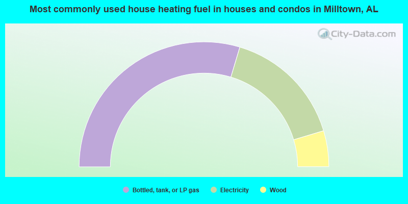
- 59.3%Bottled, tank, or LP gas
- 31.4%Electricity
- 9.3%Wood
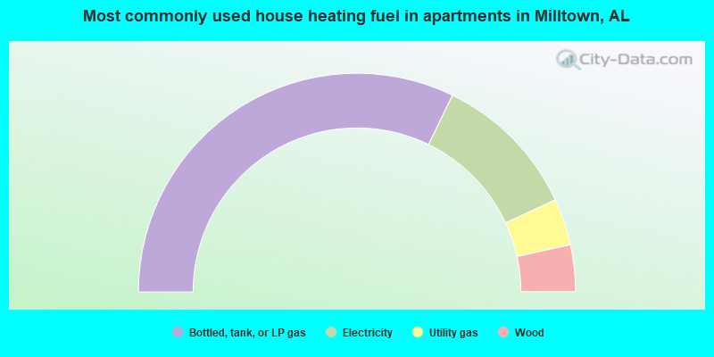
- 64.4%Bottled, tank, or LP gas
- 21.8%Electricity
- 6.9%Utility gas
- 6.9%Wood
Milltown compared to Alabama state average:
- Unemployed percentage significantly below state average.
- Hispanic race population percentage significantly below state average.
- Foreign-born population percentage significantly below state average.
- Renting percentage below state average.
- Length of stay since moving in significantly above state average.
- Number of rooms per house significantly below state average.
- House age significantly below state average.
- Number of college students significantly below state average.
- Percentage of population with a bachelor's degree or higher below state average.
Milltown on our top lists:
- #34 on the list of "Top 101 larger cities with the lowest real estate taxes percentage (population 50,000+)"
- #80 (36862) on the list of "Top 101 zip codes with the lowest 2012 average reported profit/loss from business (pop 5,000+)"
- #27 on the list of "Top 101 counties with the lowest ground withdrawal of fresh water for public supply"