Model, Tennessee
Submit your own pictures of this place and show them to the world
- OSM Map
- General Map
- Google Map
- MSN Map

| Males: 4 | |
| Females: 1 |
| Median resident age: | 15.5 years |
| Tennessee median age: | 35.9 years |
Median resident age: 15.5 years


- 480.0%White alone
- 120.0%Hispanic

 Recent articles from our blog. Our writers, many of them Ph.D. graduates or candidates, create easy-to-read articles on a wide variety of topics.
Current Local Time: CST time zone
Land area: 100.3 square miles.
Population density: 0.05 people per square mile (very low).

Nearest city with pop. 50,000+: Clarksville, TN  (33.9 miles , pop. 103,455).
Nearest city with pop. 200,000+: Metropolitan Government, TN (73.3 miles , pop. 569,891).
Nearest city with pop. 1,000,000+: Chicago, IL (363.7 miles , pop. 2,896,016).
Nearest cities:
), ), ), ), Latitude: 36.59 N, Longitude: 87.97 W
Area code commonly used in this area: 270

| Here: | 3.2% |
| Tennessee: | 3.0% |
Average climate in Model, Tennessee
Based on data reported by over 4,000 weather stations


(lower is better)

Air Quality Index (AQI) level in 2011 was 70.5. This is about average.
| City: | 70.5 |
| U.S.: | 72.6 |

Nitrogen Dioxide (NO2) [ppb] level in 2007 was 1.91. This is significantly better than average. Closest monitor was 13.1 miles away from the city center.
| City: | 1.91 |
| U.S.: | 5.11 |

Sulfur Dioxide (SO2) [ppb] level in 2007 was 1.97. This is worse than average. Closest monitor was 12.8 miles away from the city center.
| City: | 1.97 |
| U.S.: | 1.51 |

Ozone [ppb] level in 2011 was 37.2. This is about average. Closest monitor was 13.1 miles away from the city center.
| City: | 37.2 |
| U.S.: | 33.3 |
Tornado activity:
Model-area historical tornado activity is slightly above Tennessee state average. It is 64% greater than the overall U.S. average.
On 4/3/1968, a category F4 (max. wind speeds 207-260 mph) tornado 18.7 miles away from the Model place center killed 2 people and injured 30 people and caused between $500,000 and $5,000,000 in damages.
On 3/4/1964, a category F4 tornado 24.0 miles away from the place center killed 3 people and injured 24 people and caused between $50,000 and $500,000 in damages.
Earthquake activity:
Model-area historical earthquake activity is significantly above Tennessee state average. It is 274% greater than the overall U.S. average.On 4/18/2008 at 09:36:59, a magnitude 5.4 (5.1 MB, 4.8 MS, 5.4 MW, 5.2 MW, Class: Moderate, Intensity: VI - VII) earthquake occurred 129.1 miles away from the city center
On 4/18/2008 at 09:36:59, a magnitude 5.2 (5.2 MW, Depth: 8.9 mi) earthquake occurred 129.0 miles away from Model center
On 9/26/1990 at 13:18:51, a magnitude 5.0 (4.7 MB, 4.8 LG, 5.0 LG, Depth: 7.7 mi) earthquake occurred 95.5 miles away from Model center
On 6/18/2002 at 17:37:15, a magnitude 5.0 (4.3 MB, 4.6 MW, 5.0 LG) earthquake occurred 97.4 miles away from Model center
On 5/4/1991 at 01:18:54, a magnitude 5.0 (4.4 MB, 4.6 LG, 5.0 LG, Depth: 3.1 mi) earthquake occurred 103.0 miles away from Model center
On 6/10/1987 at 23:48:54, a magnitude 5.1 (4.9 MB, 4.4 MS, 4.6 MS, 5.1 LG) earthquake occurred 154.6 miles away from the city center
Magnitude types: regional Lg-wave magnitude (LG), body-wave magnitude (MB), surface-wave magnitude (MS), moment magnitude (MW)
Natural disasters:
The number of natural disasters in Stewart County (14) is near the US average (15).Major Disasters (Presidential) Declared: 11
Emergencies Declared: 2
Causes of natural disasters: Floods: 10, Storms: 9, Tornadoes: 6, Winds: 3, Winter Storms: 2, Flash Flood: 1, Hurricane: 1, Ice Storm: 1, Other: 1 (Note: some incidents may be assigned to more than one category).
Colleges/universities with over 2000 students nearest to Model:
- Murray State University (about 20 miles; Murray, KY; Full-time enrollment: 8,930)
- Hopkinsville Community College (about 34 miles; Hopkinsville, KY; FT enrollment: 2,269)
- Austin Peay State University (about 35 miles; Clarksville, TN; FT enrollment: 8,621)
- Bethel University (about 44 miles; McKenzie, TN; FT enrollment: 5,878)
- West Kentucky Community and Technical College (about 51 miles; Paducah, KY; FT enrollment: 4,107)
- The University of Tennessee-Martin (about 53 miles; Martin, TN; FT enrollment: 7,013)
- Madisonville Community College (about 60 miles; Madisonville, KY; FT enrollment: 2,082)
Points of interest:
Notable locations in Model: Model (A), Brandon Spring Group Camp (B), Ginger Ridge Back Country Camp (C), The Homeplace (D), Rushing Creek Campground (E), Camp Tischel (F), Mannings Landing (G), Dover Landing (H), Piney Campground (I). Display/hide their locations on the map
Churches in Model include: Saint Mary Church (A), Neville Creek Church (B), Tharpe Church (C), Tiptop Church (D), Azotus Church (E), Hickory Grove Church (F), Hopewell Church (G), Blue Spring Church (H), Oak Grove Church (I). Display/hide their locations on the map
Cemeteries: Houston Cemetery (1), Taylor Cemetery (2), Jimerson Cemetery (3), Vinson Cemetery (4), Wallace Cemetery (5), Keel Cemetery (6), Whitford Cemetery (7). Display/hide their locations on the map
Lakes, reservoirs, and swamps: Rawls Pond (A), Bards Lake (B), Kentucky Lake (C), Neville Bay (D). Display/hide their locations on the map
Streams, rivers, and creeks: Lost Creek (A), Lick Creek (B), Barrett Creek (C), Bards Creek (D), Hughes Creek (E), Tischel Creek (F), Ginger Creek (G), Fort Henry Branch (H), North Piney Creek (I). Display/hide their locations on the map
Parks in Model include: Bear Creek Waterfowl Management Unit (1), Blue Springs Lake Access Area (2), Boswell Landing Lake Access Area (3), Gatlin Point Lake Access (4), Ginger Bay Lake Access Area (5), Grays Landing Lake Access Area (6), Neville Bay Lake Access (7). Display/hide their locations on the map
| This place: | 5.0 people |
| Tennessee: | 2.5 people |
| This place: | 0.0% |
| Whole state: | 69.8% |
| This place: | 0.0% |
| Whole state: | 4.2% |
No gay or lesbian households reported
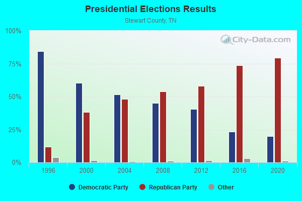
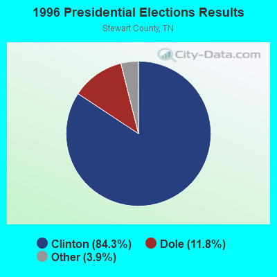
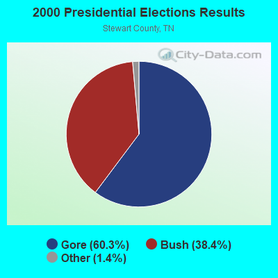
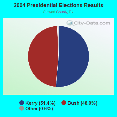
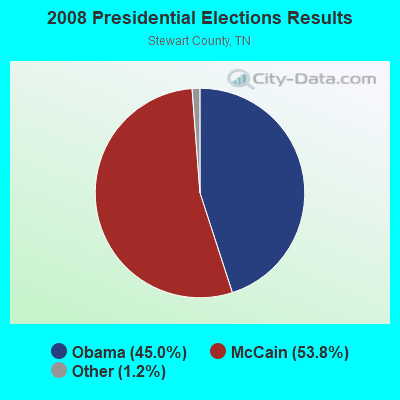
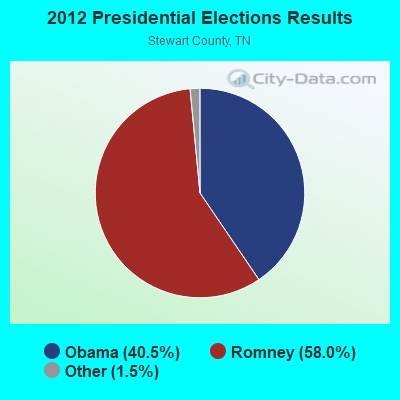
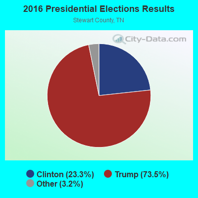
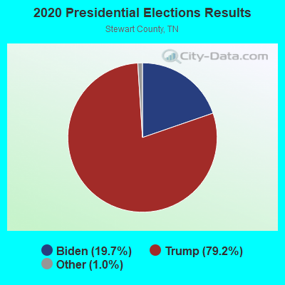
Graphs represent county-level data. Detailed 2008 Election Results
Religion statistics for Model, TN (based on Stewart County data)
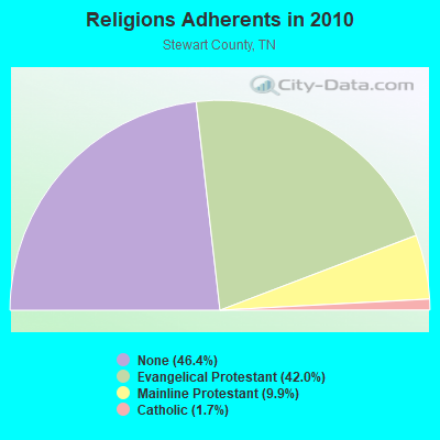
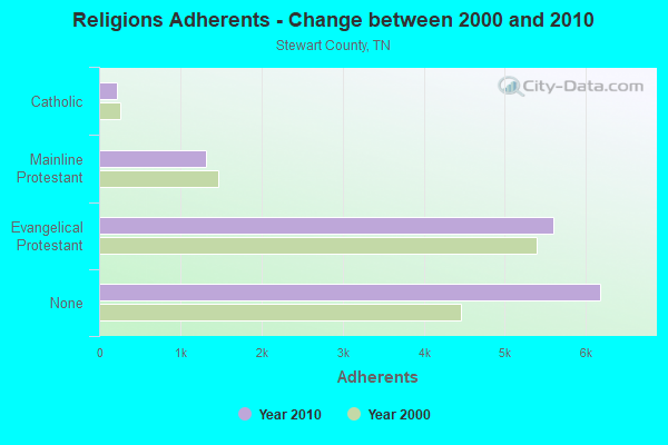
| Religion | Adherents | Congregations |
|---|---|---|
| Evangelical Protestant | 5,602 | 42 |
| Mainline Protestant | 1,321 | 14 |
| Catholic | 220 | 1 |
| Other | - | 1 |
| None | 6,181 | - |
Food Environment Statistics:
| Stewart County: | 0.77 / 10,000 pop. |
| State: | 1.99 / 10,000 pop. |
| Stewart County: | 0.77 / 10,000 pop. |
| State: | 0.65 / 10,000 pop. |
| Stewart County: | 5.37 / 10,000 pop. |
| Tennessee: | 5.16 / 10,000 pop. |
| This county: | 6.14 / 10,000 pop. |
| Tennessee: | 6.56 / 10,000 pop. |
| Here: | 11.7% |
| Tennessee: | 11.4% |
| Stewart County: | 31.3% |
| State: | 30.2% |
| This county: | 10.4% |
| Tennessee: | 13.5% |
Strongest AM radio stations in Model:
- WSM (650 AM; 50 kW; NASHVILLE, TN; Owner: GAYLORD ENTERTAINMENT COMPANY)
- WKDA (1200 AM; 50 kW; NASHVILLE, TN; Owner: RADIO NASHVILLE, INC.)
- WNQM (1300 AM; 50 kW; NASHVILLE, TN; Owner: WNQM. INC.)
- WAMB (1160 AM; 50 kW; DONELSON, TN; Owner: GREAT SOUTHERN BROADCASTING COMPANY, INC.)
- WMUF (1000 AM; daytime; 5 kW; PARIS, TN; Owner: BENTON-WEATHERFORD B/CTING OF TN,INC)
- WLAC (1510 AM; 50 kW; NASHVILLE, TN; Owner: CAPSTAR TX LIMITED PARTNERSHIP)
- WRKY (1130 AM; 2 kW; MURRAY, KY; Owner: FOREVER COMMUNICATIONS INC)
- WCBL (1290 AM; 5 kW; BENTON, KY; Owner: JIM W. FREELAND)
- WCRV (640 AM; 50 kW; COLLIERVILLE, TN; Owner: BOTT BROADCASTING COMPANY/TENNESSEE)
- WPAD (1560 AM; 10 kW; PADUCAH, KY; Owner: BRISTOL BROADCASTING COMPANY, INC.)
- WGSF (1030 AM; 50 kW; MEMPHIS, TN; Owner: FLINN BROADCASTING CORPORATION)
- WDIA (1070 AM; 50 kW; MEMPHIS, TN; Owner: CLEAR CHANNEL BROADCASTING LICENSES, INC.)
- WNBS (1340 AM; 1 kW; MURRAY, KY; Owner: FOREVER COMMUNICATIONS INC)
Strongest FM radio stations in Model:
- WCVQ (107.9 FM; FORT CAMPBELL, KY; Owner: SAGA COMMUNICATIONS OF TUCKESSEE, LLC)
- WVVR (100.3 FM; HOPKINSVILLE, KY; Owner: SAGA COMMUNICATIONS OF TUCKESSEE, LLC)
- WTPR-FM (101.5 FM; MCKINNON, TN; Owner: WENK BROADCAST GROUP)
- WFGE (103.7 FM; MURRAY, KY; Owner: FOREVER COMMUNICATIONS INC)
- WKMS-FM (91.3 FM; MURRAY, KY; Owner: MURRAY STATE UNIVERSITY)
- WKDZ-FM (106.5 FM; CADIZ, KY; Owner: HAM BROADCASTING COMPANY, INC.)
- WQZQ-FM (102.5 FM; DICKSON, TN; Owner: MONTGOMERY BROADCASTING COMPANY)
- WVHM (90.5 FM; BENTON, KY; Owner: HEARTLAND MINISTRIES, INC.)
- WAAJ (89.7 FM; BENTON, KY; Owner: HEARTLAND MINISTRIES, INC.)
TV broadcast stations around Model:
- WCKV-LP (Channel 49; CLARKSVILLE, ETC., TN; Owner: TN MEDIA GROUP, INC.)
- WQTV-LP (Channel 24; MURRAY, KY; Owner: RAYCOM AMERICA, INC.)
- WKMU (Channel 21; MURRAY, KY; Owner: KENTUCKY AUTHORITY FOR EDUCATIONAL TV)
FCC Registered Cell Phone Towers:
1 (See the full list of FCC Registered Cell Phone Towers in Model)FCC Registered Antenna Towers:
10 (See the full list of FCC Registered Antenna Towers)FCC Registered Broadcast Land Mobile Towers:
1- Four Tenths Of A Mi Nnw (Lat: 36.613944 Lon: -87.977806), Type: Tower, Structure height: 98 m, Call Sign: WNQH368,
Assigned Frequencies: 451.100 MHz, 451.200 MHz, Grant Date: 07/17/2014, Expiration Date: 09/06/2024, Registrant: Jackson Purchase 2-Way Radio Inc, 1201 S Third St, Paducah, KY 42003-1611, Phone: (270) 443-5604, Fax: (270) 443-6402, Email:
FCC Registered Microwave Towers:
2- MODEL, 206 Fire Tower Road (Lat: 36.613972 Lon: -87.977250), Type: Ltower, Structure height: 76.2 m, Overall height: 77.7 m, Call Sign: WQVD745,
Assigned Frequencies: 6197.24 MHz, 6286.19 MHz, 6256.54 MHz, 6345.49 MHz, Grant Date: 01/12/2015, Expiration Date: 01/12/2025, Certifier: John Monday, Registrant: At&t Services, Inc., 208 S Akard St, 20f, Dallas, TX 75202, Phone: (855) 699-7073, Email:
- 9NV3907B, 206 Fire Tower Road (Lat: 36.613972 Lon: -87.977250), Type: Ltower, Structure height: 76.2 m, Overall height: 77.7 m, Call Sign: WRUW575,
Assigned Frequencies: 11485.0 MHz, 11565.0 MHz, 11485.0 MHz, 11565.0 MHz, 11485.0 MHz, 11565.0 MHz, 11485.0 MHz, 11565.0 MHz, 11485.0 MHz, 11565.0 MHz... (+12 more), Grant Date: 10/12/2022, Expiration Date: 10/12/2032, Certifier: Jenny Knopf, Registrant: T-Mobile Usa, Inc., 12920 Se 38th Street, Bellevue, WA 98006, Phone: (425) 383-8401, Fax: (425) 383-4040, Email:
Model compared to Tennessee state average:
- Median household income significantly below state average.
- Median house value significantly below state average.
- Unemployed percentage significantly below state average.
- Black race population percentage significantly below state average.
- Hispanic race population percentage significantly above state average.
- Median age significantly below state average.
- Foreign-born population percentage significantly below state average.
- Renting percentage significantly below state average.
- Length of stay since moving in significantly above state average.
- Number of rooms per house significantly below state average.
- House age significantly below state average.
- Number of college students significantly below state average.
- Percentage of population with a bachelor's degree or higher significantly below state average.