New River, Tennessee
Submit your own pictures of this place and show them to the world
- OSM Map
- General Map
- Google Map
- MSN Map

| Males: 164 | |
| Females: 169 |
| Median resident age: | 40.5 years |
| Tennessee median age: | 35.9 years |
Zip code: 37710
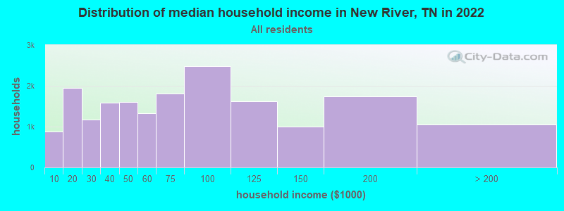
| New River: | $38,424 |
| TN: | $65,254 |
Estimated per capita income in 2022: $14,803 (it was $8,136 in 2000)
New River CCD income, earnings, and wages data
Estimated median house or condo value in 2022: $76,011 (it was $25,500 in 2000)
| New River: | $76,011 |
| TN: | $284,800 |
Mean prices in 2022: all housing units: $236,384; detached houses: $256,881; townhouses or other attached units: $177,417; in 2-unit structures: $91,925; in 3-to-4-unit structures: $104,003; in 5-or-more-unit structures: $182,437; mobile homes: $99,679
Detailed information about poverty and poor residents in New River, TN
Compare current foreclosures near New River, TN:
| Photo | Address | Area | Beds / Baths | Price | Details |
|---|---|---|---|---|---|

|
#1
East St
Oliver Springs, TN 37840
|
1,672 sq. feet
|
2 baths 5 beds |
$119,900
|
show details |

|
#2
Edgewood Dr
Powell, TN 37849
|
1,344 sq. feet
|
2 baths 3 beds |
show details | |

|
#3
Leopper Rd
Harriman, TN 37748
|
1,085 sq. feet
|
- baths - beds |
$225,000
|
show details |

|
#4
Wallace Dr
Andersonville, TN 37705
|
1,454 sq. feet
|
1 baths 3 beds |
show details | |

|
#5
Wexgate Rd
Knoxville, TN 37931
|
1,008 sq. feet
|
1 baths 3 beds |
show details | |

|
#6
Bennett Ln
Oak Ridge, TN 37830
|
768 sq. feet
|
1 baths 1 beds |
show details | |

|
#7
S Alabama Rd
Oak Ridge, TN 37830
|
1,368 sq. feet
|
2 baths 3 beds |
show details | |

|
#8
Walker Cir
Clinton, TN 37716
|
1,944 sq. feet
|
2 baths 3 beds |
show details | |

|
#9
Guinn Rd
Knoxville, TN 37931
|
1,888 sq. feet
|
1 baths 3 beds |
show details | |

|
#10
Henderson Rd
Knoxville, TN 37931
|
960 sq. feet
|
1 baths 2 beds |
show details |
| Photo | Address | Area | Beds / Baths | Price | Details |
|---|---|---|---|---|---|

|
#11
Deer Ridge Rd
Norris, TN 37828
|
1,479 sq. feet
|
2 baths - beds |
show details | |

|
#12
Dogwood Rd
Knoxville, TN 37931
|
1,646 sq. feet
|
2 baths 3 beds |
show details | |

|
#13
Woodmont Cir
Clinton, TN 37716
|
1,251 sq. feet
|
1 baths - beds |
show details | |

|
#14
Medaris St
Clinton, TN 37716
|
1,752 sq. feet
|
1 baths - beds |
show details | |

|
#15
Dutch Valley Rd
Clinton, TN 37716
|
1,107 sq. feet
|
1 baths - beds |
show details | |

|
#16
Susack Rd
Wartburg, TN 37887
|
1,104 sq. feet
|
1 baths - beds |
show details | |

|
#17
Tansi Ln
Oak Ridge, TN 37830
|
996 sq. feet
|
1 baths - beds |
show details | |

|
#18
Riverside Dr
Clinton, TN 37716
|
1,095 sq. feet
|
1 baths - beds |
show details | |

|
#19
Bruce Gap Rd
Caryville, TN 37714
|
1,248 sq. feet
|
1 baths - beds |
show details | |

|
#20
N Shorewood Ln
Caryville, TN 37714
|
2,009 sq. feet
|
3 baths - beds |
show details |
| Photo | Address | Area | Beds / Baths | Price | Details |
|---|---|---|---|---|---|

|
#21
Beets St
Clinton, TN 37716
|
858 sq. feet
|
1 baths - beds |
show details | |

|
#22
Nebraska Ave
Oak Ridge, TN 37830
|
2,028 sq. feet
|
2 baths - beds |
show details | |

|
#23
Baltimore Dr
Oak Ridge, TN 37830
|
2,564 sq. feet
|
3 baths - beds |
show details | |

|
#24
Tempura Dr
Oak Ridge, TN 37830
|
1,607 sq. feet
|
2 baths - beds |
show details | |

|
#25
Breezewood Cir
Clinton, TN 37716
|
1,493 sq. feet
|
2 baths - beds |
show details | |

|
#26
W Broad St
Clinton, TN 37716
|
1,456 sq. feet
|
2 baths - beds |
show details | |

|
#27
Dower Ln
Caryville, TN 37714
|
1,344 sq. feet
|
2 baths - beds |
show details | |

|
#28
Spring St
Clinton, TN 37716
|
984 sq. feet
|
1 baths - beds |
show details | |

|
#29
Poplar Creek Rd
Oliver Springs, TN 37840
|
672 sq. feet
|
1 baths - beds |
show details | |

|
#30
Oak Grove Rd
Lake City, TN 37769
|
1,200 sq. feet
|
1 baths - beds |
show details |
| Photo | Address | Area | Beds / Baths | Price | Details |
|---|---|---|---|---|---|

|
#31
Bermuda Rd
Oak Ridge, TN 37830
|
1,184 sq. feet
|
1 baths - beds |
show details | |

|
#32
Sinking Springs Rd
Clinton, TN 37716
|
494 sq. feet
|
1 baths - beds |
show details | |

|
#33
Boulder Rd
Wartburg, TN 37887
|
1,101 sq. feet
|
1 baths - beds |
show details | |

|
#34
Island Ford Rd
Lake City, TN 37769
|
1,096 sq. feet
|
1 baths - beds |
show details | |

|
#35
Cedar Cir
Powell, TN 37849
|
1,847 sq. feet
|
2 baths - beds |
show details | |

|
#36
Hope St
Huntsville, TN 37756
|
1,247 sq. feet
|
2 baths - beds |
show details | |

|
#37
Mehaffey Rd
Knoxville, TN 37931
|
884 sq. feet
|
1 baths - beds |
show details | |

|
#38
Parrott St
Jacksboro, TN 37757
|
1,320 sq. feet
|
1 baths - beds |
show details | |

|
#39
Raccoon Valley Rd
Powell, TN 37849
|
1,196 sq. feet
|
2 baths - beds |
show details | |

|
#40
Green St
Wartburg, TN 37887
|
896 sq. feet
|
1 baths - beds |
show details |
| Photo | Address | Area | Beds / Baths | Price | Details |
|---|---|---|---|---|---|

|
#41
Vinsant Estates Rd
Jacksboro, TN 37757
|
1,920 sq. feet
|
2 baths - beds |
show details | |

|
#42
Jane Way Ln
Jacksboro, TN 37757
|
1,660 sq. feet
|
1 baths - beds |
show details | |

|
#43
Shipe Rd
Powell, TN 37849
|
1,680 sq. feet
|
1 baths - beds |
show details | |

|
#44
Meadowview Ln
Powell, TN 37849
|
1,200 sq. feet
|
1 baths - beds |
show details | |

|
#45
Cedar Cir
Powell, TN 37849
|
1,944 sq. feet
|
1 baths - beds |
show details | |

|
#46
Rivers Run Blvd
Oak Ridge, TN 37830
|
3,448 sq. feet
|
3 baths - beds |
show details | |

|
#47
N Dogwood Rd
Powell, TN 37849
|
1,092 sq. feet
|
1 baths - beds |
show details | |

|
#48
Foust Carney Rd
Powell, TN 37849
|
1,024 sq. feet
|
1 baths - beds |
show details | |

|
#49
Gail Ln
Jacksboro, TN 37757
|
1,008 sq. feet
|
1 baths - beds |
show details | |

|
Check over 1 million property listings on Foreclosure.com!
|
browse all offers | |||

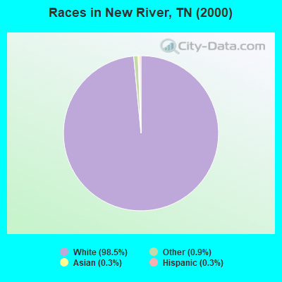
- 31998.5%White alone
- 30.9%Other race alone
- 10.3%Asian alone
- 10.3%Hispanic
Races in New River detailed stats: ancestries, foreign born residents, place of birth
 Recent articles from our blog. Our writers, many of them Ph.D. graduates or candidates, create easy-to-read articles on a wide variety of topics.

Current Local Time: EST time zone
Elevation: 1206 feet
Land area: 62.8 square miles.
Population density: 5.3 people per square mile (very low).
| New River CCD: | 1.1% ($269) |
| Tennessee: | 0.8% ($715) |
Nearest city with pop. 50,000+: Knoxville, TN  (25.7 miles , pop. 173,890).
Nearest city with pop. 200,000+: Fayette, KY (129.2 miles , pop. 260,512).
Nearest city with pop. 1,000,000+: Chicago, IL (431.6 miles , pop. 2,896,016).
Nearest cities:
), ), ), ), ), Latitude: 36.17 N, Longitude: 84.34 W

| Here: | 3.0% |
| Tennessee: | 3.0% |
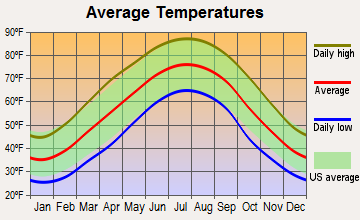
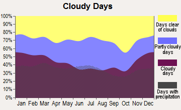
Average climate in New River, Tennessee
Based on data reported by over 4,000 weather stations
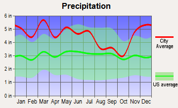
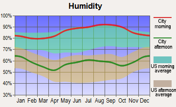
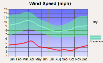

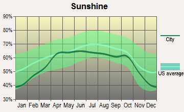
(lower is better)
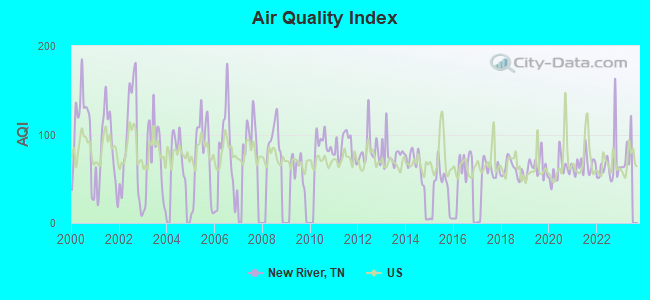
Air Quality Index (AQI) level in 2022 was 67.2. This is about average.
| City: | 67.2 |
| U.S.: | 72.6 |
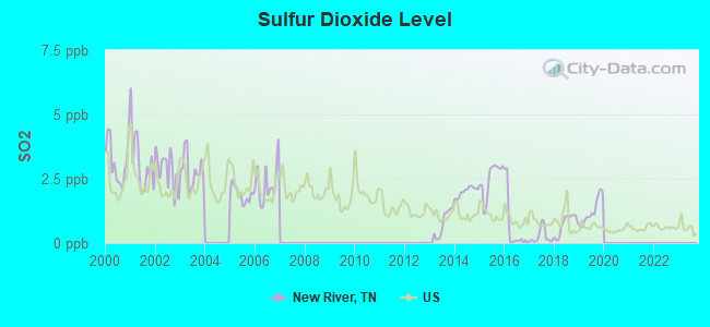
Sulfur Dioxide (SO2) [ppb] level in 2019 was 1.24. This is better than average. Closest monitor was 3.8 miles away from the city center.
| City: | 1.24 |
| U.S.: | 1.51 |
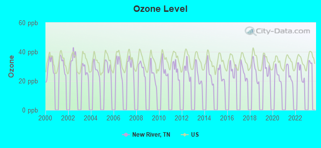
Ozone [ppb] level in 2022 was 25.8. This is better than average. Closest monitor was 14.4 miles away from the city center.
| City: | 25.8 |
| U.S.: | 33.3 |
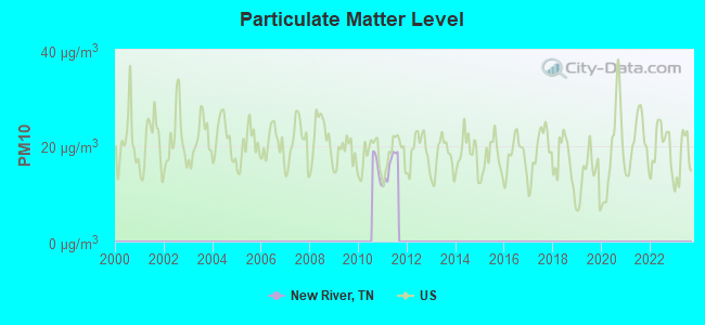
Particulate Matter (PM10) [µg/m3] level in 2011 was 15.8. This is better than average. Closest monitor was 19.4 miles away from the city center.
| City: | 15.8 |
| U.S.: | 19.2 |
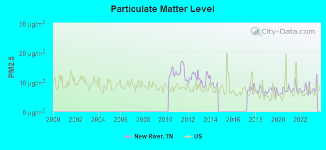
Particulate Matter (PM2.5) [µg/m3] level in 2022 was 7.19. This is about average. Closest monitor was 19.4 miles away from the city center.
| City: | 7.19 |
| U.S.: | 8.11 |
Tornado activity:
New River-area historical tornado activity is below Tennessee state average. It is 17% smaller than the overall U.S. average.
On 4/3/1974, a category F4 (max. wind speeds 207-260 mph) tornado 33.1 miles away from the New River place center killed 7 people and injured 150 people and caused between $500,000 and $5,000,000 in damages.
On 11/10/2002, a category F3 (max. wind speeds 158-206 mph) tornado 10.2 miles away from the place center killed 7 people and injured 28 people and caused $970,000 in damages.
Earthquake activity:
New River-area historical earthquake activity is significantly above Tennessee state average. It is 91% greater than the overall U.S. average.On 11/30/1973 at 07:48:41, a magnitude 4.7 (4.7 MB, 4.6 ML, Class: Light, Intensity: IV - V) earthquake occurred 32.9 miles away from the city center
On 7/27/1980 at 18:52:21, a magnitude 5.2 (5.1 MB, 4.7 MS, 5.0 UK, 5.2 UK, Class: Moderate, Intensity: VI - VII) earthquake occurred 142.7 miles away from the city center
On 4/29/2003 at 08:59:39, a magnitude 4.9 (4.4 MB, 4.6 MW, 4.9 LG) earthquake occurred 136.7 miles away from New River center
On 8/9/2020 at 12:07:37, a magnitude 5.1 (5.1 MW, Depth: 4.7 mi) earthquake occurred 182.0 miles away from the city center
On 12/12/2018 at 09:14:43, a magnitude 4.4 (4.4 MW, Depth: 4.9 mi) earthquake occurred 44.2 miles away from New River center
On 4/18/2008 at 09:36:59, a magnitude 5.4 (5.1 MB, 4.8 MS, 5.4 MW, 5.2 MW) earthquake occurred 251.3 miles away from the city center
Magnitude types: regional Lg-wave magnitude (LG), body-wave magnitude (MB), local magnitude (ML), surface-wave magnitude (MS), moment magnitude (MW)
Natural disasters:
The number of natural disasters in Anderson County (18) is near the US average (15).Major Disasters (Presidential) Declared: 13
Emergencies Declared: 2
Causes of natural disasters: Floods: 13, Storms: 11, Tornadoes: 6, Winter Storms: 3, Winds: 2, Fire: 1, Heavy Rain: 1, Hurricane: 1, Landslide: 1, Mudslide: 1, Snowfall: 1, Other: 1 (Note: some incidents may be assigned to more than one category).
Hospitals and medical centers near New River:
- ST MARYS NORTH HOSPITAL (Hospital, about 11 miles away; LAKE CITY, TN)
- PROCARE OF OAK RIDGE INC (Home Health Center, about 11 miles away; OAK RIDGE, TN)
- RIDGEVIEW PSYCHIATRIC HOSPITAL AND CENTER (Hospital, about 11 miles away; OAK RIDGE, TN)
- SUMMIT VIEW OF LAKE CITY, LLC (Nursing Home, about 12 miles away; LAKE CITY, TN)
- FMC OAK RIDGE (Dialysis Facility, about 12 miles away; OAK RIDGE, TN)
- NHC HEALTHCARE, OAK RIDGE (Nursing Home, about 12 miles away; OAK RIDGE, TN)
- METHODIST MEDICAL CTR HOME HEALTH SVCS (Home Health Center, about 12 miles away; OAK RIDGE, TN)
Colleges/universities with over 2000 students nearest to New River:
- Pellissippi State Community College (about 18 miles; Knoxville, TN; Full-time enrollment: 7,271)
- Roane State Community College (about 26 miles; Harriman, TN; FT enrollment: 4,302)
- The University of Tennessee-Knoxville (about 27 miles; Knoxville, TN; FT enrollment: 25,483)
- University of the Cumberlands (about 41 miles; Williamsburg, KY; FT enrollment: 3,585)
- Lincoln Memorial University (about 48 miles; Harrogate, TN; FT enrollment: 3,706)
- Walters State Community College (about 61 miles; Morristown, TN; FT enrollment: 4,359)
- Somerset Community College (about 64 miles; Somerset, KY; FT enrollment: 4,698)
Points of interest:
Churches in New River include: New Pilot Baptist Church (A), Shiloh Church (B), Rock Hill Church (C), Grave Hill Baptist Church (D), Beech Grove Church (E). Display/hide their locations on the map
Cemeteries: Jones Cemetery (1), Asslinger Cemetery (2), Lively Cemetery (3), Beech Grove Cemetery (4), Lowe Cemetery (5), Reeves-Daugherty Cemetery (6), Matt Phillips Cemetery (7). Display/hide their locations on the map
Streams, rivers, and creeks: Lower Fork (A), Ligias Fork (B), Lick Branch (C), Laurel Fork (D), Joe Branch (E), Jack Branch (F), Indian Fork (G), Gum Branch (H), Graves Gap Branch (I). Display/hide their locations on the map
Birthplace of: Josephus S. Cecil - Army Medal of Honor recipient.
| This place: | 2.5 people |
| Tennessee: | 2.5 people |
| This place: | 72.7% |
| Whole state: | 69.8% |
| This place: | 3.0% |
| Whole state: | 4.2% |
No gay or lesbian households reported
| This place: | 25.0% |
| Whole state: | 13.5% |
| This place: | 13.1% |
| Whole state: | 5.8% |
For population 15 years and over in New River:
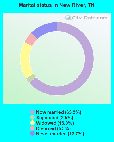
- Never married: 12.7%
- Now married: 65.2%
- Separated: 2.5%
- Widowed: 16.8%
- Divorced: 5.3%
For population 25 years and over in New River:
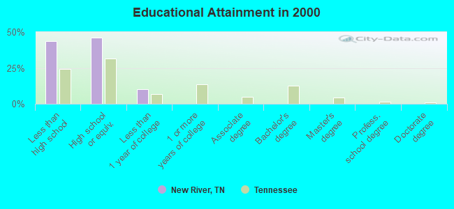
- High school or higher: 56.4%
- Bachelor's degree or higher: 0.0%
- Graduate or professional degree: 0.0%
- Unemployed: 9.6%
- Mean travel time to work (commute): 68.8 minutes
| Here: | 13.9 |
| Tennessee average: | 13.3 |


Graphs represent county-level data. Detailed 2008 Election Results
Religion statistics for New River, TN (based on Anderson County data)
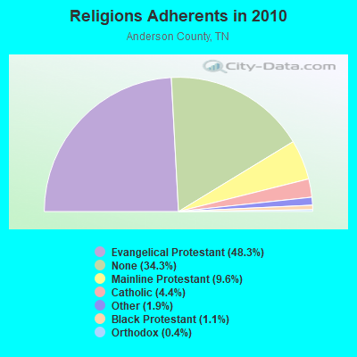
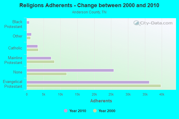
| Religion | Adherents | Congregations |
|---|---|---|
| Evangelical Protestant | 36,312 | 94 |
| Mainline Protestant | 7,220 | 21 |
| Catholic | 3,295 | 3 |
| Other | 1,434 | 6 |
| Black Protestant | 810 | 4 |
| Orthodox | 280 | 1 |
| None | 25,778 | - |
Food Environment Statistics:
| Anderson County: | 2.18 / 10,000 pop. |
| State: | 1.99 / 10,000 pop. |
| This county: | 0.14 / 10,000 pop. |
| State: | 0.17 / 10,000 pop. |
| Anderson County: | 0.82 / 10,000 pop. |
| State: | 0.65 / 10,000 pop. |
| Anderson County: | 5.05 / 10,000 pop. |
| Tennessee: | 5.16 / 10,000 pop. |
| Anderson County: | 5.05 / 10,000 pop. |
| State: | 6.56 / 10,000 pop. |
| This county: | 13.5% |
| Tennessee: | 11.4% |
| Here: | 28.6% |
| Tennessee: | 30.2% |
| This county: | 13.0% |
| Tennessee: | 13.5% |
Strongest AM radio stations in New River:
- WKVL (850 AM; daytime; 50 kW; KNOXVILLE, TN; Owner: HORNE RADIO, LLC)
- WATO (1290 AM; 5 kW; OAK RIDGE, TN)
- WQBB (1040 AM; daytime; 10 kW; POWELL, TN; Owner: JOURNAL BROADCAST CORPORATION)
- WECO (940 AM; 5 kW; WARTBURG, TN; Owner: MORGAN COUNTY B/CASTING CO.)
- WNOX (990 AM; 10 kW; KNOXVILLE, TN)
- WMTY (670 AM; daytime; 2 kW; FARRAGUT, TN; Owner: HORNE RADIO, LLC)
- WVLZ (1180 AM; daytime; 10 kW; KNOXVILLE, TN; Owner: KIRKLAND WIRELESS BROADCASTERS, INC.)
- WRJZ (620 AM; 5 kW; KNOXVILLE, TN; Owner: TENNESSEE MEDIA ASSOCIATES, INC)
- WYSH (1380 AM; 1 kW; CLINTON, TN; Owner: CLINTON BROADCASTERS, INC.)
- WWAM (820 AM; daytime; 50 kW; JASPER, TN; Owner: SHELTON BROADCASTING SYSTEM)
- WFLI (1070 AM; 50 kW; LOOKOUT MOUNTAIN, TN; Owner: WFLI, INC.)
- WSM (650 AM; 50 kW; NASHVILLE, TN; Owner: GAYLORD ENTERTAINMENT COMPANY)
- WLFJ (660 AM; daytime; 50 kW; GREENVILLE, SC; Owner: CLEAR CHANNEL BROADCASTING LICENSES, INC.)
Strongest FM radio stations in New River:
- WDVX (89.9 FM; CLINTON, TN; Owner: CUMBERLAND COMMUNITIES COMMUNI CORP.)
- WOKI-FM (100.3 FM; OAK RIDGE, TN; Owner: OAK RIDGE FM, INC.)
- WUOT (91.9 FM; KNOXVILLE, TN; Owner: UNIVERSITY OF TENNESSEE)
- WECO-FM (101.3 FM; WARTBURG, TN; Owner: MORGAN COUNTY BROADCASTING CO., INC.)
- WJXB-FM (97.5 FM; KNOXVILLE, TN; Owner: SOUTH CENTRAL COMMUNICATIONS CORP.)
- WIMZ-FM (103.5 FM; KNOXVILLE, TN; Owner: SOUTH CENTRAL COMM., CORP.)
- WYLV (89.1 FM; ALCOA, TN; Owner: FOOTHILLS BROADCASTING, INC.)
- WYFC (95.3 FM; CLINTON, TN; Owner: BIBLE BROADCASTING NETWORK, INC.)
- WIVK-FM (107.7 FM; KNOXVILLE, TN; Owner: CITADEL BROADCASTING COMPANY)
- WWST (102.1 FM; SEVIERVILLE, TN; Owner: JOURNAL BROADCAST CORPORATION)
- WWSR (105.7 FM; ROCKWOOD, TN; Owner: SOUTHERN MEDIA GROUP, INC.)
- WRMX-FM (106.7 FM; NORRIS, TN; Owner: SOUTH CENTRAL COMMUNICATIONS CORPORATION)
- WBZH (92.7 FM; HARRIMAN, TN; Owner: SOUTHERN MEDIA GROUP, INC.)
- WMYU (93.1 FM; KARNS, TN; Owner: JOURNAL BROADCAST CORPORATION)
- WQLA-FM (104.9 FM; LA FOLLETTE, TN; Owner: LAFOLLETTE BROADCASTERS, INC.)
- WMIK-FM (92.7 FM; MIDDLESBORO, KY; Owner: GATEWAY BROADCASTING, INC.)
- WMKW (89.3 FM; CROSSVILLE, TN; Owner: THE MOODY BIBLE INSTITUTE OF CHICAGO)
- WNFZ (94.3 FM; OAK RIDGE, TN; Owner: JOHN W. PIRKLE)
- WYIL-FM (98.7 FM; OLIVER SPRINGS, TN; Owner: CITADEL BROADCASTING COMPANY)
- WEKX (102.7 FM; JELLICO, TN; Owner: WHITLEY BROADCASTING CO., INC.)
TV broadcast stations around New River:
- WVLT-TV (Channel 8; KNOXVILLE, TN; Owner: WVLT LICENSEE CORP.)
- WKOP-TV (Channel 15; KNOXVILLE, TN; Owner: EAST TENNESSEE PUBLIC COMMUNICATIONS CORP.)
- WBIR-TV (Channel 10; KNOXVILLE, TN; Owner: GANNETT PACIFIC CORPORATION)
- WATE-TV (Channel 6; KNOXVILLE, TN; Owner: WATE, G.P.)
- WDTT-LP (Channel 38; LENOIR CITY, TN; Owner: WORD OF GOD FELLOWSHIP, INC.)
- WTNZ (Channel 43; KNOXVILLE, TN; Owner: RAYCOM AMERICA, INC.)
- W46DC (Channel 46; KNOXVILLE, TN; Owner: TRINITY BROADCASTING NETWORK)
- WEEE-LP (Channel 32; KNOXVILLE, TN; Owner: TIGER EYE BROADCASTING CORPORATION)
- WEZK-LP (Channel 28; KNOXVILLE, TN; Owner: SOUTH CENTRAL COMMUNICATIONS CORP.)
- W50CG (Channel 50; KNOXVILLE, TN; Owner: THREE ANGELS BROADCASTING NETWORK, INC.)
- WPXK (Channel 54; JELLICO, TN; Owner: PAXSON KNOXVILLE LICENSE, INC.)
- WFEM-LP (Channel 12; HEISKELL, ETC., TN; Owner: H. EARL MARLAR)
- W56CM (Channel 56; KNOXVILLE, TN; Owner: VENTANA TELEVISION, INC.)
Medal of Honor Recipients
Medal of Honor Recipient born in New River: Josephus S. Cecil.
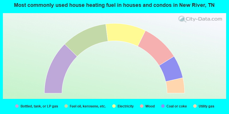
- 24.8%Bottled, tank, or LP gas
- 21.2%Fuel oil, kerosene, etc.
- 18.6%Electricity
- 17.7%Wood
- 10.6%Coal or coke
- 7.1%Utility gas
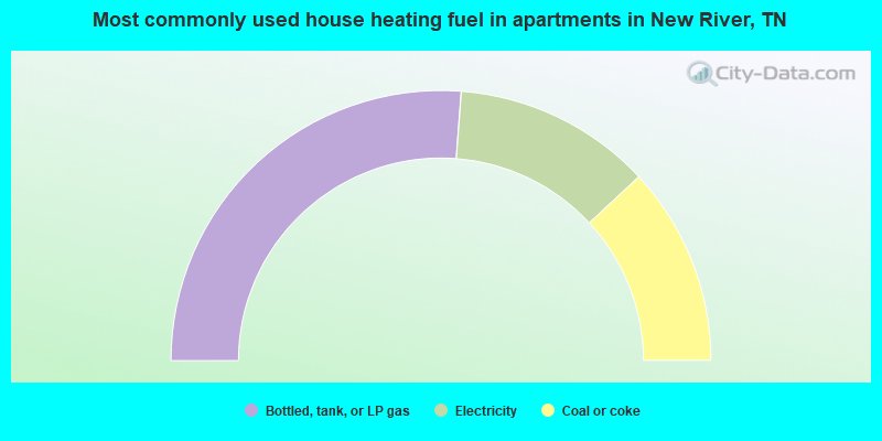
- 52.4%Bottled, tank, or LP gas
- 23.8%Electricity
- 23.8%Coal or coke
New River compared to Tennessee state average:
- Median household income below state average.
- Median house value significantly below state average.
- Black race population percentage significantly below state average.
- Hispanic race population percentage significantly below state average.
- Foreign-born population percentage significantly below state average.
- Renting percentage significantly below state average.
- Length of stay since moving in significantly above state average.
- Number of rooms per house significantly below state average.
- House age significantly below state average.
- Number of college students significantly below state average.
- Percentage of population with a bachelor's degree or higher significantly below state average.
New River on our top lists:
- #8 on the list of "Top 100 cities with longest commuting times"
- #71 on the list of "Top 101 counties with the highest number of deaths per 1000 residents 2007-2013 (pop. 50,000+)"