Niangua, Missouri

Niangua: Missouri red bud in Niangua

Niangua: apple tree blooming in town
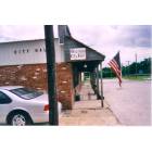
Niangua: Niangua City Hall
- add
your


Submit your own pictures of this city and show them to the world
(32.1% for White Non-Hispanic residents, 66.7% for American Indian residents, 4.5% for two or more races residents)
Detailed information about poverty and poor residents in Niangua, MO
Full-time law enforcement employees in 2021, including police officers: 1 (1 officers - 0 male; 1 female).
| Officers per 1,000 residents here: | 2.35 |
| Missouri average: | 2.54 |
 Recent articles from our blog. Our writers, many of them Ph.D. graduates or candidates, create easy-to-read articles on a wide variety of topics.

| Here: | 2.3% |
| Missouri: | 2.8% |
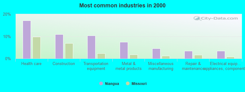
- Health care (17.1%)
- Construction (10.9%)
- Transportation equipment (10.3%)
- Metal & metal products (7.4%)
- Miscellaneous manufacturing (4.6%)
- Repair & maintenance (3.4%)
- Electrical equipment, appliances, components (3.4%)
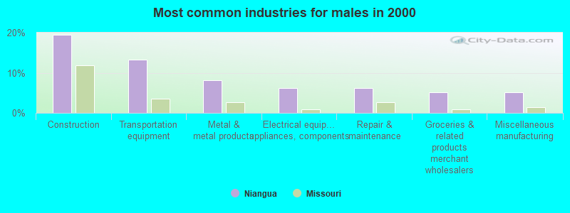
- Construction (19.4%)
- Transportation equipment (13.3%)
- Metal & metal products (8.2%)
- Electrical equipment, appliances, components (6.1%)
- Repair & maintenance (6.1%)
- Groceries & related products merchant wholesalers (5.1%)
- Miscellaneous manufacturing (5.1%)
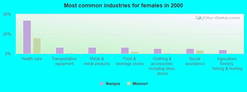
- Health care (33.8%)
- Transportation equipment (6.5%)
- Metal & metal products (6.5%)
- Food & beverage stores (6.5%)
- Clothing & accessories, including shoe, stores (5.2%)
- Social assistance (5.2%)
- Agriculture, forestry, fishing & hunting (3.9%)
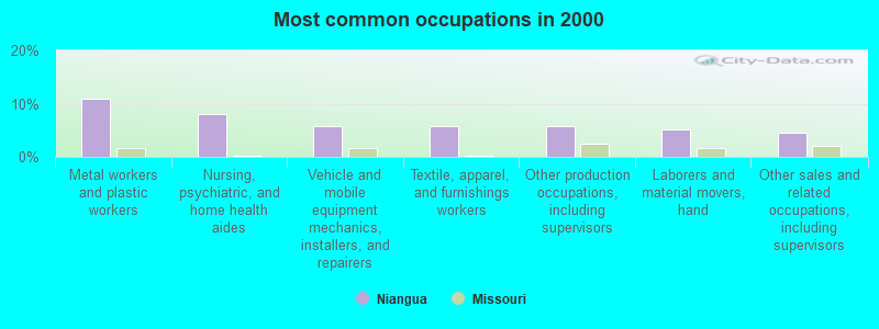
- Metal workers and plastic workers (10.9%)
- Nursing, psychiatric, and home health aides (8.0%)
- Vehicle and mobile equipment mechanics, installers, and repairers (5.7%)
- Textile, apparel, and furnishings workers (5.7%)
- Other production occupations, including supervisors (5.7%)
- Laborers and material movers, hand (5.1%)
- Other sales and related occupations, including supervisors (4.6%)
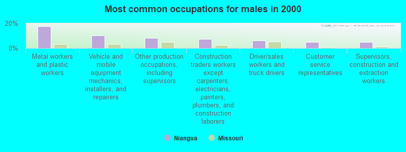
- Metal workers and plastic workers (17.3%)
- Vehicle and mobile equipment mechanics, installers, and repairers (10.2%)
- Other production occupations, including supervisors (8.2%)
- Construction traders workers except carpenters, electricians, painters, plumbers, and construction laborers (7.1%)
- Driver/sales workers and truck drivers (6.1%)
- Customer service representatives (5.1%)
- Supervisors, construction and extraction workers (5.1%)
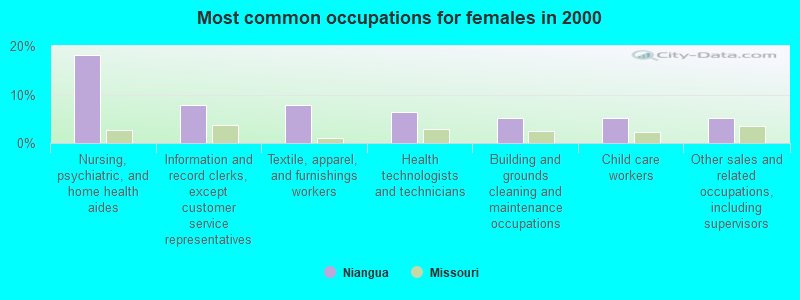
- Nursing, psychiatric, and home health aides (18.2%)
- Information and record clerks, except customer service representatives (7.8%)
- Textile, apparel, and furnishings workers (7.8%)
- Health technologists and technicians (6.5%)
- Building and grounds cleaning and maintenance occupations (5.2%)
- Child care workers (5.2%)
- Other sales and related occupations, including supervisors (5.2%)
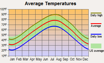
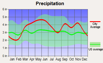
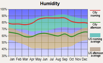
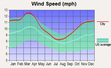
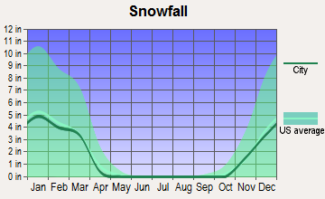
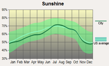
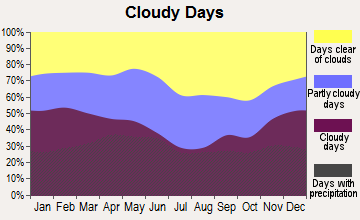
Average climate in Niangua, Missouri
Based on data reported by over 4,000 weather stations
Tornado activity:
Niangua-area historical tornado activity is slightly below Missouri state average. It is 26% greater than the overall U.S. average.
On 9/26/1959, a category F4 (max. wind speeds 207-260 mph) tornado 9.3 miles away from the Niangua city center caused between $50,000 and $500,000 in damages.
On 11/29/1991, a category F4 tornado 25.1 miles away from the city center killed 2 people and injured 64 people and caused between $5,000,000 and $50,000,000 in damages.
Earthquake activity:
Niangua-area historical earthquake activity is significantly above Missouri state average. It is 519% greater than the overall U.S. average.On 9/3/2016 at 12:02:44, a magnitude 5.8 (5.8 MW, Depth: 3.5 mi, Class: Moderate, Intensity: VI - VII) earthquake occurred 236.2 miles away from Niangua center
On 11/6/2011 at 03:53:10, a magnitude 5.7 (5.7 MW, Depth: 3.2 mi) earthquake occurred 253.7 miles away from Niangua center
On 5/4/1991 at 01:18:54, a magnitude 5.0 (4.4 MB, 4.6 LG, 5.0 LG, Depth: 3.1 mi) earthquake occurred 175.7 miles away from the city center
On 9/26/1990 at 13:18:51, a magnitude 5.0 (4.7 MB, 4.8 LG, 5.0 LG, Depth: 7.7 mi) earthquake occurred 182.0 miles away from Niangua center
On 3/25/1976 at 00:41:20, a magnitude 5.0 (4.9 MB, 5.0 LG) earthquake occurred 184.5 miles away from the city center
On 4/18/2008 at 09:36:59, a magnitude 5.4 (5.1 MB, 4.8 MS, 5.4 MW, 5.2 MW) earthquake occurred 279.6 miles away from Niangua center
Magnitude types: regional Lg-wave magnitude (LG), body-wave magnitude (MB), surface-wave magnitude (MS), moment magnitude (MW)
Natural disasters:
The number of natural disasters in Webster County (28) is a lot greater than the US average (15).Major Disasters (Presidential) Declared: 19
Emergencies Declared: 6
Causes of natural disasters: Floods: 21, Storms: 19, Tornadoes: 14, Winds: 6, Winter Storms: 5, Drought: 1, Heavy Rain: 1, Hurricane: 1, Other: 1 (Note: some incidents may be assigned to more than one category).
Colleges/universities with over 2000 students nearest to Niangua:
- Evangel University (about 27 miles; Springfield, MO; Full-time enrollment: 2,036)
- Ozarks Technical Community College (about 28 miles; Springfield, MO; FT enrollment: 10,356)
- Drury University (about 28 miles; Springfield, MO; FT enrollment: 3,902)
- Missouri State University-Springfield (about 28 miles; Springfield, MO; FT enrollment: 16,660)
- Southwest Baptist University (about 36 miles; Bolivar, MO; FT enrollment: 2,783)
- Missouri University of Science and Technology (about 70 miles; Rolla, MO; FT enrollment: 6,486)
- Lincoln University (about 89 miles; Jefferson City, MO; FT enrollment: 2,348)
Public high school in Niangua:
- NIANGUA HIGH (Students: 120, Location: 301 RUMSEY ST, Grades: 7-12)
Public elementary/middle school in Niangua:
- NIANGUA ELEM. (Students: 107, Location: 301 RUMSEY ST, Grades: PK-6)
Points of interest:
Notable location: Niangua Fire Department (A). Display/hide its location on the map
Birthplace of: Roy Blunt - Politician.
Drinking water stations with addresses in Niangua that have no violations reported:
- MO ST FREE WILL BAPTIST YOUTH CAMP (Population served: 300, Primary Water Source Type: Groundwater)
| This city: | 2.3 people |
| Missouri: | 2.5 people |
| This city: | 64.9% |
| Whole state: | 65.3% |
| This city: | 10.9% |
| Whole state: | 6.7% |
Likely homosexual households (counted as self-reported same-sex unmarried-partner households)
- Lesbian couples: 0.0% of all households
- Gay men: 0.6% of all households

| Here: | 6.8 |
| Missouri average: | 11.1 |
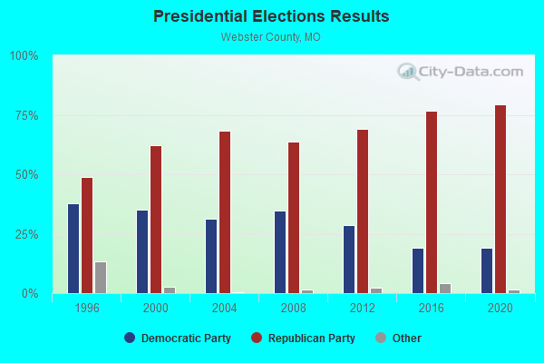
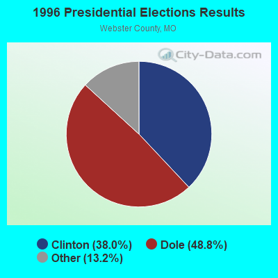
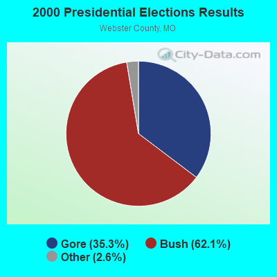
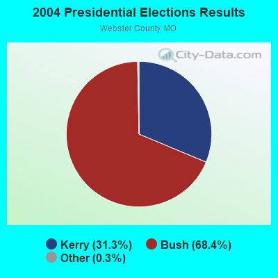
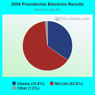

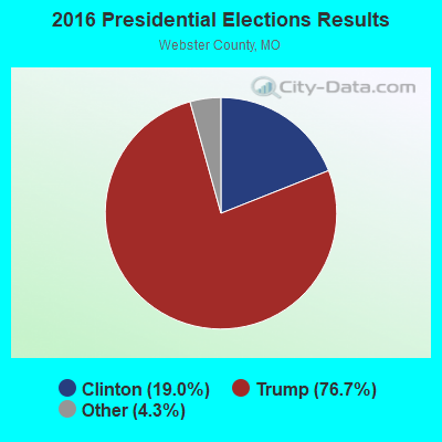
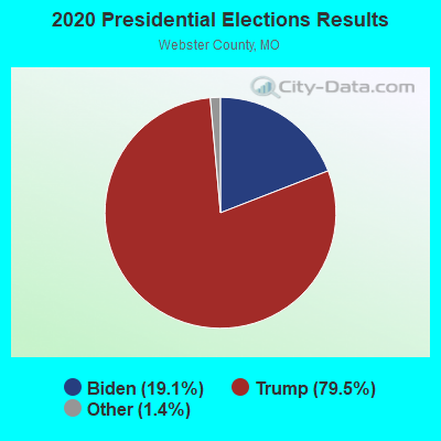
Graphs represent county-level data. Detailed 2008 Election Results
Religion statistics for Niangua, MO (based on Webster County data)
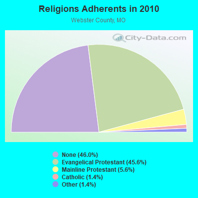
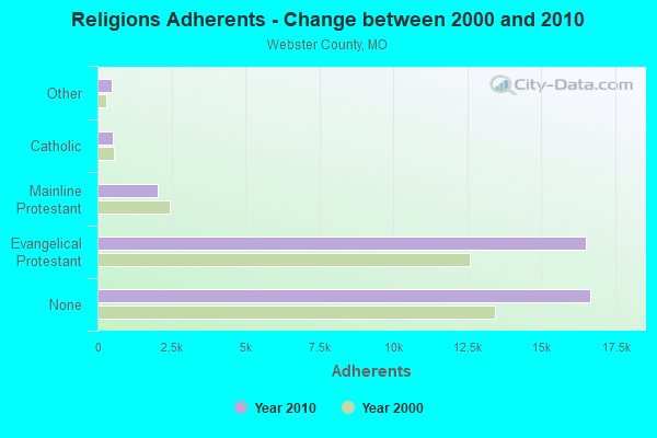
| Religion | Adherents | Congregations |
|---|---|---|
| Evangelical Protestant | 16,507 | 81 |
| Mainline Protestant | 2,035 | 13 |
| Catholic | 504 | 1 |
| Other | 491 | 1 |
| Orthodox | 2 | 1 |
| None | 16,663 | - |
Food Environment Statistics:
| Webster County: | 1.11 / 10,000 pop. |
| Missouri: | 1.88 / 10,000 pop. |
| Webster County: | 0.56 / 10,000 pop. |
| Missouri: | 0.60 / 10,000 pop. |
| Webster County: | 5.85 / 10,000 pop. |
| Missouri: | 4.34 / 10,000 pop. |
| Webster County: | 3.90 / 10,000 pop. |
| Missouri: | 7.37 / 10,000 pop. |
| Here: | 7.9% |
| Missouri: | 8.8% |
| Here: | 29.0% |
| Missouri: | 29.6% |
| This county: | 11.3% |
| Missouri: | 13.5% |
Health and Nutrition:
| This city: | 49.9% |
| Missouri: | 50.9% |
| Here: | 46.9% |
| Missouri: | 48.6% |
| Niangua: | 28.6 |
| Missouri: | 28.7 |
| Here: | 24.1% |
| Missouri: | 20.6% |
| This city: | 5.8% |
| Missouri: | 10.1% |
| Niangua: | 6.8 |
| Missouri: | 6.8 |
| Niangua: | 31.9% |
| State: | 34.3% |
| Niangua: | 57.5% |
| Missouri: | 57.5% |
| Niangua: | 76.0% |
| Missouri: | 79.3% |
More about Health and Nutrition of Niangua, MO Residents
| Local government employment and payroll (March 2022) | |||||
| Function | Full-time employees | Monthly full-time payroll | Average yearly full-time wage | Part-time employees | Monthly part-time payroll |
|---|---|---|---|---|---|
| Water Supply | 1 | $2,994 | $35,928 | 0 | $0 |
| Other Government Administration | 0 | $0 | 7 | $4,604 | |
| Police Protection - Officers | 0 | $0 | 1 | $85 | |
| Totals for Government | 1 | $2,994 | $35,928 | 8 | $4,689 |
Niangua government finances - Expenditure in 2017 (per resident):
- Current Operations - Central Staff Services: $48,000 ($119.70)
Sewerage: $26,000 ($64.84)
Water Utilities: $23,000 ($57.36)
Police Protection: $8,000 ($19.95)
General Public Buildings: $5,000 ($12.47)
- Total Salaries and Wages: $71,000 ($177.06)
Niangua government finances - Revenue in 2017 (per resident):
- Charges - Sewerage: $57,000 ($142.14)
- Revenue - Water Utilities: $43,000 ($107.23)
- State Intergovernmental - Highways: $1,000 ($2.49)
- Tax - General Sales and Gross Receipts: $24,000 ($59.85)
Property: $4,000 ($9.98)
Motor Vehicle License: $3,000 ($7.48)
Public Utilities Sales: $1,000 ($2.49)
Niangua government finances - Cash and Securities in 2017 (per resident):
- Other Funds - Cash and Securities: $54,000 ($134.66)
Strongest AM radio stations in Niangua:
- KMRF (1510 AM; daytime; 5 kW; MARSHFIELD, MO; Owner: NEW LIFE EVANGELISTIC CENTER, INC.)
- KBNN (750 AM; daytime; 5 kW; LEBANON, MO; Owner: OZARK BROADCASTING, INC.)
- KWTO (560 AM; 5 kW; SPRINGFIELD, MO; Owner: KWTO, INC.)
- KSGF (1260 AM; 5 kW; SPRINGFIELD, MO; Owner: JOURNAL BROADCAST CORPORATION)
- KLFJ (1550 AM; 5 kW; SPRINGFIELD, MO; Owner: 127, INC.)
- KRMS (1150 AM; 10 kW; OSAGE BEACH, MO; Owner: VIPER COMMUNICATIONS, INC)
- WHB (810 AM; 50 kW; KANSAS CITY, MO; Owner: UNION BROADCASTING, INC.)
- KLWT (1230 AM; 1 kW; LEBANON, MO; Owner: PEARSON BROADCASTING OF LEBANON, INC.)
- KJPW (1390 AM; 5 kW; WAYNESVILLE, MO; Owner: PULASKI COUNTY BROADCASTERS, INC.)
- KGHT (880 AM; 50 kW; SHERIDAN, AR; Owner: METROPOLITAN RADIO GROUP, INC.)
- KXEN (1010 AM; 50 kW; FESTUS-ST. LOUIS, MO; Owner: BDJ RADIO ENTERPRISES, LLC)
- KRMG (740 AM; 50 kW; TULSA, OK; Owner: CXR HOLDINGS, INC.)
- KMOX (1120 AM; 50 kW; ST. LOUIS, MO; Owner: INFINITY BROADCASTING OPERATIONS, INC.)
Strongest FM radio stations in Niangua:
- KTXR (101.3 FM; SPRINGFIELD, MO; Owner: STEREO BROADCASTING, INC.)
- KWFC (89.1 FM; SPRINGFIELD, MO; Owner: BAPTIST BIBLE COLLEGE, INC.)
- KJEL (103.7 FM; LEBANON, MO; Owner: OZARK BROADCASTING, INC.)
- KXUS (97.3 FM; SPRINGFIELD, MO; Owner: CLEAR CHANNEL BROADCASTING LICENSES, INC.)
- KKLH (104.7 FM; MARSHFIELD, MO; Owner: MW SPRINGMO, INC.)
- KTTS-FM (94.7 FM; SPRINGFIELD, MO; Owner: JOURNAL BROADCAST CORPORATION)
- KNLM (91.9 FM; MARSHFIELD, MO; Owner: NEW LIFE EVANGELISTIC CENTER, INC.)
- KBFL (99.9 FM; BUFFALO, MO; Owner: MEYER-BALDRIDGE, INC.)
- KSCV (90.1 FM; SPRINGFIELD, MO; Owner: COMMUNITY BROADCASTING, INC.)
- KTTK (90.7 FM; LEBANON, MO; Owner: LEBANON EDUCATIONAL BROADCASTING FOUNDATION)
- KGBX-FM (105.9 FM; NIXA, MO; Owner: CLEAR CHANNEL BROADCASTING LICENSES, INC.)
- KTOZ-FM (95.5 FM; PLEASANT HOPE, MO; Owner: CLEAR CHANNEL BROADCASTING LICENSES, INC.)
- KWND (88.3 FM; SPRINGFIELD, MO; Owner: RADIO TRAINING NETWORK, INC)
- KCLQ (107.9 FM; LEBANON, MO; Owner: PEARSON BROADCASTING OF LEBANON, INC.)
- KSPW (96.5 FM; SPARTA, MO; Owner: JOURNAL BROADCAST CORPORATION)
TV broadcast stations around Niangua:
- KYTV (Channel 3; SPRINGFIELD, MO; Owner: KY3, INC.)
- KSPR (Channel 33; SPRINGFIELD, MO; Owner: PIEDMONT TELEVISION OF SPRINGFIELD LICENSE LLC)
- KOLR (Channel 10; SPRINGFIELD, MO; Owner: VHR SPRINGFIELD LICENSE, INC.)
- KDEB-TV (Channel 27; SPRINGFIELD, MO; Owner: QUORUM OF MISSOURI LICENSE, LLC)
- KOZK (Channel 21; SPRINGFIELD, MO; Owner: BD. OF GOVERNORS OF SW MISSOURI STATE UNIVERSITY)
- KWBS-LP (Channel 56; SPRINGFIELD, MO; Owner: EQUITY BROADCASTING CORPORATION)
- K68EL (Channel 68; MARSHFIELD, MO; Owner: NEW LIFE EVANGELISTIC CENTER, INC.)
- K41FQ (Channel 41; SPRINGFIELD, MO; Owner: TRINITY BROADCASTING NETWORK)
- K15CZ (Channel 15; SPRINGFIELD, MO; Owner: KY3, INC.)
- K64FQ (Channel 64; LEBANON, MO; Owner: NEW LIFE EVANGELISTIC CENTER, INC.)
- National Bridge Inventory (NBI) Statistics
- 15Number of bridges
- 95ft / 28.8mTotal length
- $510,000Total costs
- 40,152Total average daily traffic
- 9,505Total average daily truck traffic
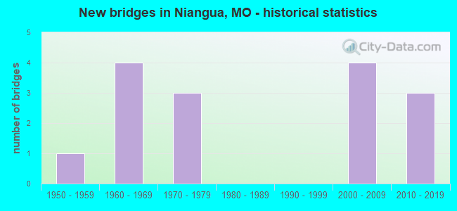
- New bridges - historical statistics
- 11950-1959
- 41960-1969
- 31970-1979
- 42000-2009
- 32010-2019
FCC Registered Cell Phone Towers:
1 (See the full list of FCC Registered Cell Phone Towers in Niangua)FCC Registered Antenna Towers:
15 (See the full list of FCC Registered Antenna Towers)FCC Registered Broadcast Land Mobile Towers:
1- Lat: 37.392639 Lon: -92.831833, Call Sign: WRZE914,
Assigned Frequencies: 154.490 MHz, 154.515 MHz, Grant Date: 10/25/2023, Expiration Date: 10/25/2033, Certifier: David Baker, Registrant: Mark Steele Communications, 5620 S Mccann Ave, Springfield, MO 65804, Phone: (417) 882-0119, Email:
FCC Registered Microwave Towers:
3- SPARKLE BRK, 2.5 Miles Nw Of (Lat: 37.418917 Lon: -92.863778), Overall height: 66.4 m, Call Sign: WOF93, Licensee ID: L00115313,
Assigned Frequencies: 3750.00 MHz, 3770.00 MHz, 3750.00 MHz, 3770.00 MHz, 3830.00 MHz, 3850.00 MHz, 3830.00 MHz, 3850.00 MHz, 3910.00 MHz, 3930.00 MHz... (+14 more), Grant Date: 02/13/2001, Expiration Date: 02/01/2011, Cancellation Date: 05/10/2004, Registrant: Mci Worldcom Network Services, Inc. (Debtor-In-Possession)
- MORGAN, 15 Mi N Of Marshfield N Side Hwy Cc (Lat: 37.473333 Lon: -92.837778), Type: Tower, Structure height: 100.6 m, Overall height: 105.2 m, Call Sign: WPNB525,
Assigned Frequencies: 6315.84 MHz, 6197.24 MHz, Grant Date: 02/08/2011, Expiration Date: 02/01/2021, Cancellation Date: 02/10/2020, Certifier: Kenneth R Meyers, Registrant: Holland & Knight LLP, 800 17th Street, N.W., Suite #1100, Washington, DC 20006-3906, Phone: (202) 955-3000, Fax: (202) 955-5564, Email:
- 092 Niangua, Lat: 37.391444 Lon: -92.832222, Type: Tank, Structure height: 30.5 m, Call Sign: WQIX995,
Assigned Frequencies: 3650.00 MHz, Grant Date: 08/01/2018, Expiration Date: 10/17/2020, Cancellation Date: 12/19/2020, Certifier: Craig A House, Registrant: Total Highspeed, LLC, 1091 Kathryn St, Nixa, MO 65714, Phone: (417) 851-1107, Fax: (636) 794-0291, Email:
FCC Registered Amateur Radio Licenses:
14 (See the full list of FCC Registered Amateur Radio Licenses in Niangua)| Home Mortgage Disclosure Act Aggregated Statistics For Year 2003 (Based on 1 partial tract) | ||
| C) Refinancings | ||
|---|---|---|
| Number | Average Value | |
| LOANS ORIGINATED | 1 | $62,720 |
| APPLICATIONS APPROVED, NOT ACCEPTED | 0 | $0 |
| APPLICATIONS DENIED | 0 | $0 |
| APPLICATIONS WITHDRAWN | 0 | $0 |
| FILES CLOSED FOR INCOMPLETENESS | 0 | $0 |
Detailed HMDA statistics for the following Tracts: 9701.00
2002 - 2018 National Fire Incident Reporting System (NFIRS) incidents
- Fire incident types reported to NFIRS in Niangua, MO
- 8453.8%Outside Fires
- 5334.0%Structure Fires
- 106.4%Mobile Property/Vehicle Fires
- 95.8%Other
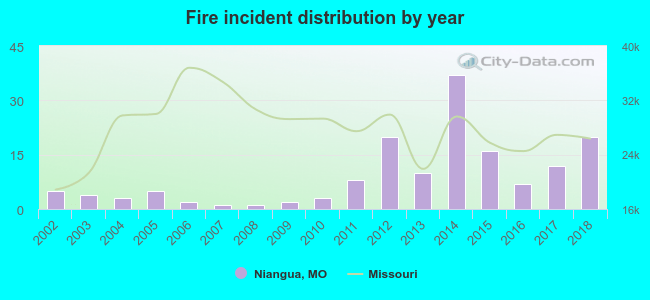 According to the data from the years 2002 - 2018 the average number of fires per year is 9. The highest number of fire incidents - 37 took place in 2014, and the least - 1 in 2007. The data has an increasing trend.
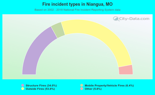 When looking into fire subcategories, the most incidents belonged to: Outside Fires (53.8%), and Structure Fires (34.0%).
| Most common first names in Niangua, MO among deceased individuals | ||
| Name | Count | Lived (average) |
|---|---|---|
| James | 19 | 68.2 years |
| William | 17 | 77.3 years |
| John | 13 | 73.7 years |
| Robert | 13 | 68.7 years |
| Mary | 10 | 76.1 years |
| Charles | 8 | 71.1 years |
| Roy | 8 | 78.4 years |
| George | 7 | 78.0 years |
| Carl | 6 | 71.8 years |
| Joseph | 6 | 80.0 years |
| Most common last names in Niangua, MO among deceased individuals | ||
| Last name | Count | Lived (average) |
|---|---|---|
| Cantrell | 18 | 77.7 years |
| Letterman | 18 | 74.6 years |
| Buttram | 11 | 70.7 years |
| Smith | 10 | 75.7 years |
| Thomas | 10 | 78.3 years |
| Brown | 10 | 78.9 years |
| Rader | 9 | 74.3 years |
| Sell | 8 | 75.1 years |
| Vestal | 8 | 85.2 years |
| Perryman | 8 | 77.1 years |
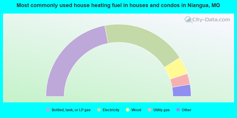
- 44.1%Bottled, tank, or LP gas
- 38.2%Electricity
- 7.8%Wood
- 4.9%Utility gas
- 2.9%Other fuel
- 2.0%No fuel used
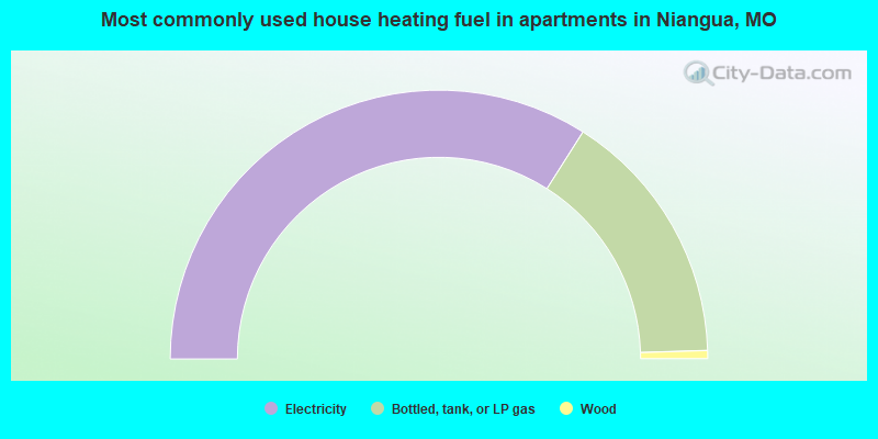
- 68.0%Electricity
- 31.0%Bottled, tank, or LP gas
- 1.0%Wood
Niangua compared to Missouri state average:
- Median household income below state average.
- Median house value significantly below state average.
- Black race population percentage significantly below state average.
- Median age above state average.
- Foreign-born population percentage significantly below state average.
- Percentage of population with a bachelor's degree or higher significantly below state average.