North Hilo, Hawaii

Submit your own pictures of this place and show them to the world
- OSM Map
- General Map
- Google Map
- MSN Map

| Males: 1,019 | |
| Females: 978 |
| Median resident age: | 40.4 years |
| Hawaii median age: | 36.2 years |
Zip code: 96780
| North Hilo: | $72,707 |
| HI: | $92,458 |
Estimated per capita income in 2022: $29,991 (it was $14,955 in 2000)
North Hilo CCD income, earnings, and wages data
Estimated median house or condo value in 2022: $427,377 (it was $124,000 in 2000)
| North Hilo: | $427,377 |
| HI: | $820,100 |
Mean prices in 2022: all housing units: $595,903; detached houses: $598,158; townhouses or other attached units: $648,474; in 2-unit structures: over $1,000,000; in 3-to-4-unit structures: $549,649; in 5-or-more-unit structures: $517,976; mobile homes: $220,909; occupied boats, rvs, vans, etc.: $401,772
Detailed information about poverty and poor residents in North Hilo, HI
Compare current foreclosures near North Hilo, HI:
| Photo | Address | Area | Beds / Baths | Price | Details |
|---|---|---|---|---|---|

|
#1
Road C
Papaikou, HI 96781
|
- sq. feet
|
- baths - beds |
show details | |

|
Check over 1 million property listings on Foreclosure.com!
|
browse all offers | |||

- 57833.6%Asian alone
- 45326.3%White alone
- 42224.5%Two or more races
- 1659.6%Hispanic
- 915.3%Native Hawaiian and Other
Pacific Islander alone - 80.5%American Indian alone
- 30.2%Black alone

Races in North Hilo detailed stats: ancestries, foreign born residents, place of birth
 Recent articles from our blog. Our writers, many of them Ph.D. graduates or candidates, create easy-to-read articles on a wide variety of topics.

Current Local Time: HST (no DST) time zone
Land area: 322.4 square miles.
Population density: 6.2 people per square mile (very low).

| North Hilo CCD: | 0.2% ($209) |
| Hawaii: | 0.3% ($765) |
Nearest city with pop. 50,000+: Honolulu, HI  (193.0 miles , pop. 371,657).
Nearest city with pop. 1,000,000+: Los Angeles, CA (2455.2 miles , pop. 3,694,820).
Nearest cities:
), ), ), ), ), )Latitude: 19.94 N, Longitude: 155.23 W


| Here: | 2.6% |
| Hawaii: | 2.9% |

- Accommodation & food services (15.5%)
- Construction (12.8%)
- Educational services (12.8%)
- Health care (7.8%)
- Professional, scientific, technical services (6.2%)
- Food & beverage stores (5.8%)
- Agriculture, forestry, fishing & hunting (5.4%)

- Construction (21.4%)
- Accommodation & food services (15.7%)
- Agriculture, forestry, fishing & hunting (9.0%)
- Food & beverage stores (5.4%)
- Administrative & support & waste management services (5.4%)
- Educational services (4.6%)
- Professional, scientific, technical services (4.1%)

- Educational services (21.3%)
- Accommodation & food services (15.4%)
- Health care (13.7%)
- Professional, scientific, technical services (8.4%)
- Food & beverage stores (6.2%)
- Social assistance (4.6%)
- Construction (3.8%)

- Building and grounds cleaning and maintenance occupations (10.3%)
- Other teachers, instructors, education, training, and library occupations (5.0%)
- Cooks and food preparation workers (4.7%)
- Driver/sales workers and truck drivers (4.1%)
- Registered nurses (4.0%)
- Other protective service workers, including supervisors (3.6%)
- Farmers and farm managers (3.3%)

- Building and grounds cleaning and maintenance occupations (13.7%)
- Driver/sales workers and truck drivers (8.0%)
- Farmers and farm managers (6.4%)
- Other protective service workers, including supervisors (6.2%)
- Painters and paperhangers (5.9%)
- Cooks and food preparation workers (5.2%)
- Material recording, scheduling, dispatching, and distributing workers (3.6%)

- Other teachers, instructors, education, training, and library occupations (10.0%)
- Registered nurses (8.1%)
- Building and grounds cleaning and maintenance occupations (6.7%)
- Cashiers (6.2%)
- Accountants and auditors (6.2%)
- Cooks and food preparation workers (4.3%)
- Counselors, social workers, and other community and social service specialists (4.3%)
Average climate in North Hilo, Hawaii
Based on data reported by over 4,000 weather stations


(lower is better)

Air Quality Index (AQI) level in 2022 was 28.0. This is significantly better than average.
| City: | 28.0 |
| U.S.: | 72.6 |

Sulfur Dioxide (SO2) [ppb] level in 2022 was 0.329. This is significantly better than average. Closest monitor was 17.3 miles away from the city center.
| City: | 0.329 |
| U.S.: | 1.515 |

Particulate Matter (PM2.5) [µg/m3] level in 2022 was 3.67. This is significantly better than average. Closest monitor was 17.3 miles away from the city center.
| City: | 3.67 |
| U.S.: | 8.11 |
Earthquake activity:
North Hilo-area historical earthquake activity is significantly above Hawaii state average. It is 2522% greater than the overall U.S. average.On 11/29/1975 at 14:47:40, a magnitude 7.2 (6.0 MB, 7.1 MS, 7.2 UK, 7.2 MS, Class: Major, Intensity: VIII - XII) earthquake occurred 36.2 miles away from North Hilo center, causing 2 deaths (2 shaking deaths)
On 5/4/2018 at 22:32:54, a magnitude 6.9 (6.9 MW, Depth: 3.6 mi, Class: Strong, Intensity: VII - IX) earthquake occurred 45.7 miles away from North Hilo center
On 8/21/1951 at 10:57:00, a magnitude 6.9 (6.9 UK) earthquake occurred 52.1 miles away from North Hilo center
On 11/16/1983 at 16:13:00, a magnitude 6.7 (6.4 MB, 6.7 MS, 6.7 MW) earthquake occurred 36.3 miles away from North Hilo center, causing $6,000,000 total damage
On 10/15/2006 at 17:07:49, a magnitude 6.7 (6.7 MD, Depth: 23.7 mi) earthquake occurred 46.3 miles away from the city center
On 10/15/2006 at 17:07:49, a magnitude 6.7 (6.2 MB, 6.6 MS, 6.7 MW) earthquake occurred 50.1 miles away from the city center
Magnitude types: body-wave magnitude (MB), duration magnitude (MD), surface-wave magnitude (MS), moment magnitude (MW)
Natural disasters:
The number of natural disasters in Hawaii County (21) is greater than the US average (15).Major Disasters (Presidential) Declared: 11
Causes of natural disasters: Fires: 7, Earthquakes: 4, Floods: 3, Storms: 3, Volcanic Eruptions: 3, Hurricanes: 2, Lava Flows: 2, High Surf: 1, Mudslide: 1, Tropical Storm: 1, Tsunami Wave: 1, Other: 1 (Note: some incidents may be assigned to more than one category).
Colleges/universities with over 2000 students nearest to North Hilo:
- University of Hawaii at Hilo (about 20 miles; Hilo, HI; Full-time enrollment: 3,161)
- Hawaii Community College (about 20 miles; Hilo, HI; FT enrollment: 2,137)
- University of Hawaii Maui College (about 105 miles; Kahului, HI; FT enrollment: 2,492)
- Kapiolani Community College (about 191 miles; Honolulu, HI; FT enrollment: 5,069)
- Chaminade University of Honolulu (about 192 miles; Honolulu, HI; FT enrollment: 2,610)
- University of Hawaii at Manoa (about 192 miles; Honolulu, HI; FT enrollment: 16,461)
- Hawaii Pacific University (about 195 miles; Honolulu, HI; FT enrollment: 5,506)
Points of interest:
Notable locations in North Hilo: Keawewai Cabin (A), Waiākea Camp (B), Keanakolu Ranger Station (C), Kanakaleonui Ranger Station (D), Laumai‘a (E), Kanakaleonui Cabin (F), Spring Water Camp (G), Nauhi Camp (H), Kahinahina Forest Cabin (I), Humu‘ula Sheep Station (J), Shack Camp (K), Hale Pohaku Ranger Station (L), Ookala Landing (M), Laupāhoehoe Public and School Library (N), Laupahoehoe Volunteer Fire Station 17A (O), Hawaii County Fire Department Station 17 Laupahoehoe (P). Display/hide their locations on the map
Church in North Hilo: Saint Anthonys Catholic Church (A). Display/hide its location on the map
Cemetery: Saint Anthonys Catholic Cemetery (1). Display/hide its location on the map
Lake: Paeoopu Pool (A). Display/hide its location on the map
Streams, rivers, and creeks: Makahiloa Stream (A), Pa‘iniu Stream (B), Umauma Stream (C), Paeohe Stream (D), Peleau Stream (E), Wa‘awa‘a Stream (F), Maulua Stream (G), Kapili Stream (H), Kaoheanu Stream (I). Display/hide their locations on the map
Parks in North Hilo include: Mauna Kea State Park - Halepōhaku Area (1), Ookala Park (2), Waikaumalo Park (3), Doctor David Douglas Historical Monument (4). Display/hide their locations on the map
| This place: | 2.8 people |
| Hawaii: | 2.9 people |
| This place: | 71.9% |
| Whole state: | 68.9% |
| This place: | 8.7% |
| Whole state: | 7.3% |
Likely homosexual households (counted as self-reported same-sex unmarried-partner households)
- Lesbian couples: 0.6% of all households
- Gay men: 0.7% of all households
| This place: | 9.3% |
| Whole state: | 10.7% |
| This place: | 6.4% |
| Whole state: | 5.0% |
For population 15 years and over in North Hilo:

- Never married: 34.3%
- Now married: 52.7%
- Separated: 0.7%
- Widowed: 7.1%
- Divorced: 5.9%
For population 25 years and over in North Hilo:
- High school or higher: 77.4%
- Bachelor's degree or higher: 15.2%
- Graduate or professional degree: 4.0%
- Unemployed: 4.2%
- Mean travel time to work (commute): 36.6 minutes


| Here: | 14.5 |
| Hawaii average: | 12.8 |
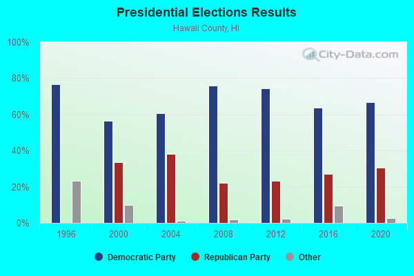
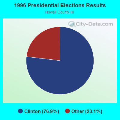
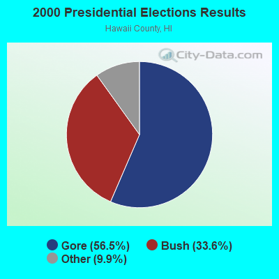
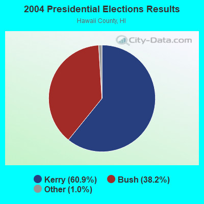

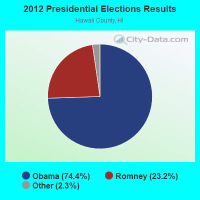
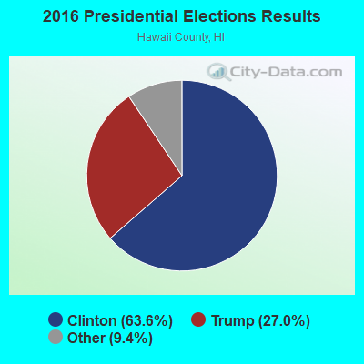
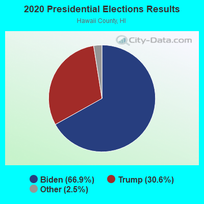
Graphs represent county-level data. Detailed 2008 Election Results
Religion statistics for North Hilo, HI (based on Hawaii County data)
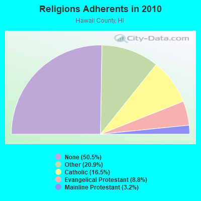
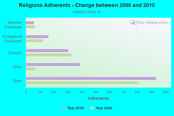
| Religion | Adherents | Congregations |
|---|---|---|
| Other | 38,701 | 88 |
| Catholic | 30,616 | 22 |
| Evangelical Protestant | 16,302 | 120 |
| Mainline Protestant | 5,882 | 43 |
| Orthodox | 25 | 1 |
| None | 93,553 | - |
Food Environment Statistics:
| Here: | 2.09 / 10,000 pop. |
| State: | 2.30 / 10,000 pop. |
| Hawaii County: | 0.06 / 10,000 pop. |
| State: | 0.09 / 10,000 pop. |
| Hawaii County: | 1.97 / 10,000 pop. |
| Hawaii: | 1.57 / 10,000 pop. |
| Hawaii County: | 2.55 / 10,000 pop. |
| Hawaii: | 1.72 / 10,000 pop. |
| This county: | 8.29 / 10,000 pop. |
| State: | 9.00 / 10,000 pop. |
| This county: | 7.1% |
| Hawaii: | 8.1% |
| Hawaii County: | 21.2% |
| Hawaii: | 20.8% |
| This county: | 10.3% |
| State: | 9.2% |
5.92% of this county's 2021 resident taxpayers lived in other counties in 2020 ($88,163 average adjusted gross income)
| Here: | 5.92% |
| Hawaii average: | 4.91% |
0.03% of residents moved from foreign countries ($348 average AGI)
Hawaii County: 0.03% Hawaii average: 0.19%
Top counties from which taxpayers relocated into this county between 2020 and 2021:
| from Honolulu County, HI | |
| from Maui County, HI | |
| from Los Angeles County, CA |
4.50% of this county's 2020 resident taxpayers moved to other counties in 2021 ($58,837 average adjusted gross income)
| Here: | 4.50% |
| Hawaii average: | 5.53% |
0.03% of residents moved to foreign countries ($272 average AGI)
Hawaii County: 0.03% Hawaii average: 0.15%
Top counties to which taxpayers relocated from this county between 2020 and 2021:
| to Honolulu County, HI | |
| to Clark County, NV | |
| to Maui County, HI |
Strongest AM radio stations in North Hilo:
- KIPA (620 AM; 10 kW; NAALEHU, HI; Owner: BIG ISLAND RADIO)
- KPUA (670 AM; 10 kW; HILO, HI; Owner: NEW WEST BROADCASTING CORP.)
- KHLO (850 AM; 5 kW; HILO, HI; Owner: MAVERICK MEDIA OF HAWAII LICENSE, LLC)
- KHBC (1060 AM; 5 kW; HILO, HI; Owner: HILO BROADCASTING, L.L.C.)
- KUAU (1570 AM; 50 kW; HAIKU, HI; Owner: FIRST ASSEMBLY OF GOD-KAHULUI, MAUI)
- KAIM (870 AM; 50 kW; HONOLULU, HI; Owner: SALEM MEDIA OF HAWAII, INC.)
- KKON (790 AM; 5 kW; KEALAKEKUA, HI; Owner: BIG ISLAND RADIO ( HAWAII LIMITED PA)
- KMVI (550 AM; 5 kW; WAILUKU, HI; Owner: PACIFIC RADIO GROUP,INC.)
- KNUI (900 AM; 5 kW; KAHULUI, HI; Owner: PACIFIC RADIO GROUP, INC.)
- KAOI (1110 AM; 5 kW; KIHEI, HI; Owner: VISIONARY RELATED ENTERTAINMENT, INC)
- KORL (690 AM; 10 kW; HONOLULU, HI; Owner: NEW WAVE BROADCASTING, L.P.)
- KGU (760 AM; 10 kW; HONOLULU, HI; Owner: SALEM MEDIA OF HAWAII, INC.)
- KHNR (650 AM; 10 kW; HONOLULU, HI; Owner: SALEM MEDIA OF HAWAII, INC.)
Strongest FM radio stations in North Hilo:
- KNUQ (103.7 FM; PAAUILO, HI; Owner: VISIONARY RELATED ENTERTAINMENT II,)
- KAGB (99.1 FM; WAIMEA, HI; Owner: BIG ISLAND RADIO)
- KLUA (93.9 FM; KAILUA KONA, HI; Owner: BIG ISLAND RADIO)
- KAOY (101.5 FM; KEALAKEKUA, HI; Owner: BIG ISLAND RADIO ( HAWAII LIMITED PA)
- KLEO (106.1 FM; KAHALUU, HI; Owner: MAVERICK MEDIA OF HAWAII LICENSE, LLC)
- KKUA (90.7 FM; WAILUKU, HI; Owner: HAWAII PUBLIC RADIO, INC.)
- KWYI (106.9 FM; KAWAIHAE, HI; Owner: COLIN H. NAITO)
- KCIF (90.3 FM; HILO, HI; Owner: HILO CHRISTIAN BROADCASTING CORP.)
TV broadcast stations around North Hilo:
- KGMD-TV (Channel 9; HILO, HI; Owner: EMMIS TELEVISION LICENSE CORPORATION)
- K67BA (Channel 67; HAKALAU, HI; Owner: HAWAII PUBLIC TELEVISION FOUNDATION)
- KWHH (Channel 14; HILO, HI; Owner: LESEA BROADCASTING CORPORATION)
- KHAW-TV (Channel 11; HILO, HI; Owner: EMMIS TELEVISION LICENSE CORPORATION)
- KHVO (Channel 13; HILO, HI; Owner: KITV HEARST-ARGYLE TV, INC. (CA CORP.))
FCC Registered Cell Phone Towers:
1- Saddle Road Site Addle Road Humuula Relay Station (Lat: 19.718639 Lon: -155.453611), Type: Pole, Structure height: 24.4 m, Overall height: 30.2 m, Call Sign: KNKN222
Assigned Frequencies: 880.020 MHz, 835.020 MHz, 891.510 MHz, 846.510 MHz, 880.020 MHz, 880.020 MHz, 835.020 MHz, 835.020 MHz, 891.510 MHz, 891.510 MHz, 846.510 MHz, 846.510 MHzGrant Date: 10/23/2018, Expiration Date: 11/27/2028, Certifier: John T Scott IiiRegistrant: Cellco Partnership, 5055 North Point Pkwy, Np2ne Network Engineering, Alpharetta, GA 30022, Phone: (770) 797-1070, Fax: (770) 797-1036, Email:

- 42.2%Electricity
- 36.7%No fuel used
- 13.9%Bottled, tank, or LP gas
- 4.3%Wood
- 2.4%Solar energy
- 0.4%Utility gas

- 76.1%Electricity
- 23.9%No fuel used
North Hilo compared to Hawaii state average:
- Median house value below state average.
- Unemployed percentage significantly below state average.
- Black race population percentage significantly below state average.
- Foreign-born population percentage significantly below state average.
- Renting percentage below state average.
- Length of stay since moving in significantly above state average.
- Number of rooms per house significantly below state average.
- House age significantly below state average.
- Number of college students below state average.
- Percentage of population with a bachelor's degree or higher below state average.
North Hilo on our top lists:
- #11 on the list of "Top 101 larger cities with the lowest real estate taxes percentage (population 50,000+)"
- #52 (96780) on the list of "Top 101 zip codes with the largest percentage of Irish first ancestries"
- #97 (96780) on the list of "Top 101 zip codes with the largest percentage of Portuguese first ancestries"
- #1 on the list of "Top 101 counties with the highest Sulfur Oxides Annual air pollution readings in 2012 (µg/m3)"
- #27 on the list of "Top 101 counties with the lowest average weight of females"
- #50 on the list of "Top 101 counties with the highest percentage of residents that exercised in the past month"
- #59 on the list of "Top 101 counties with highest percentage of residents voting for Obama (Democrat) in the 2012 Presidential Election"
- #61 on the list of "Top 101 counties with the most Other congregations (pop. 50,000+)"