Oil Springs, Kentucky
Submit your own pictures of this place and show them to the world
- OSM Map
- General Map
- Google Map
- MSN Map

| Males: 1,640 | |
| Females: 1,762 |
| Median resident age: | 36.6 years |
| Kentucky median age: | 35.9 years |
Zip code: 41222
| Oil Springs: | $44,754 |
| KY: | $59,341 |
Estimated per capita income in 2022: $21,677 (it was $13,101 in 2000)
Oil Springs CCD income, earnings, and wages data
Estimated median house or condo value in 2022: $156,515 (it was $55,200 in 2000)
| Oil Springs: | $156,515 |
| KY: | $196,300 |
Mean prices in 2022: all housing units: $182,946; detached houses: $219,470; townhouses or other attached units: $79,879; mobile homes: $69,598
Detailed information about poverty and poor residents in Oil Springs, KY
Compare current foreclosures near Oil Springs, KY:
| Photo | Address | Area | Beds / Baths | Price | Details |
|---|---|---|---|---|---|

|
#1
Ky Route 40 W
Oil Springs, KY 41238
|
1,400 sq. feet
|
2 baths 3 beds |
show details | |

|
#2
Moccasin Br
Oil Springs, KY 41238
|
- sq. feet
|
- baths - beds |
show details | |

|
#3
Win Rd
Oil Springs, KY 41238
|
- sq. feet
|
- baths - beds |
show details | |

|
#4
3rd St
Paintsville, KY 41240
|
1,598 sq. feet
|
1 baths 3 beds |
show details | |

|
#5
Ky Route 3224
River, KY 41254
|
1,420 sq. feet
|
2 baths 3 beds |
show details | |

|
#6
Kentucky Rte 3224
River, KY 41254
|
- sq. feet
|
- baths - beds |
$23,900
|
show details |

|
#7
Auxier Ave
Paintsville, KY 41240
|
1,722 sq. feet
|
1 baths 4 beds |
show details | |

|
#8
Dicey Frk
Meally, KY 41234
|
1,545 sq. feet
|
2 baths 3 beds |
show details | |

|
#9
Murray Dr
Sitka, KY 41255
|
864 sq. feet
|
1 baths 3 beds |
show details | |

|
#10
Ky Route 201
Sitka, KY 41255
|
1,932 sq. feet
|
3 baths 5 beds |
show details |
| Photo | Address | Area | Beds / Baths | Price | Details |
|---|---|---|---|---|---|

|
#11
Church Dr
Paintsville, KY 41240
|
2,352 sq. feet
|
2 baths 4 beds |
show details | |

|
#12
Buffalo Rd
Meally, KY 41234
|
1,672 sq. feet
|
2 baths 3 beds |
show details | |

|
#13
Jack Arnett Br
Prestonsburg, KY 41653
|
384 sq. feet
|
1 baths 2 beds |
show details | |

|
#14
Lyons Dr
Paintsville, KY 41240
|
2,296 sq. feet
|
2 baths 3 beds |
show details | |

|
#15
Ky Route 1596
Boons Camp, KY 41204
|
2,510 sq. feet
|
2 baths 3 beds |
show details | |

|
#16
N Mays Ave
Prestonsburg, KY 41653
|
988 sq. feet
|
1 baths 2 beds |
show details | |

|
#17
Clyde Davis Dr
Tomahawk, KY 41262
|
1,232 sq. feet
|
1 baths 3 beds |
show details | |

|
#18
Brawley St
Martin, KY 41649
|
952 sq. feet
|
1 baths 2 beds |
show details | |

|
#19
Prater Frk
Hueysville, KY 41640
|
1,536 sq. feet
|
1 baths 3 beds |
show details | |

|
#20
Ky Route 993
Paintsville, KY 41240
|
1,536 sq. feet
|
1 baths 3 beds |
show details |
| Photo | Address | Area | Beds / Baths | Price | Details |
|---|---|---|---|---|---|

|
#21
Clark Dr
Prestonsburg, KY 41653
|
- sq. feet
|
2 baths 3 beds |
show details | |

|
#22
Delong Rd
Hagerhill, KY 41222
|
2,048 sq. feet
|
- baths - beds |
show details | |

|
#23
Royalton Rd
Salyersville, KY 41465
|
- sq. feet
|
- baths - beds |
show details | |

|
#24
Conley Fork Rd
Prestonsburg, KY 41653
|
938 sq. feet
|
- baths - beds |
show details | |

|
#25
Ranger Rd
Salyersville, KY 41465
|
- sq. feet
|
- baths - beds |
show details | |

|
#26
Buffalo Creek Rd
Salyersville, KY 41465
|
- sq. feet
|
- baths - beds |
show details | |

|
#27
Dodson Br
Prestonsburg, KY 41653
|
- sq. feet
|
- baths - beds |
show details | |

|
#28
Ky Route 469
Flatgap, KY 41219
|
- sq. feet
|
- baths - beds |
show details | |

|
#29
Superior Rd
Salyersville, KY 41465
|
- sq. feet
|
- baths - beds |
show details | |

|
#30
Salt Lick Rd
Salyersville, KY 41465
|
- sq. feet
|
- baths - beds |
show details |
| Photo | Address | Area | Beds / Baths | Price | Details |
|---|---|---|---|---|---|

|
#31
Greasy Br
Hagerhill, KY 41222
|
- sq. feet
|
- baths - beds |
show details | |

|
#32
Madison Ave
Prestonsburg, KY 41653
|
- sq. feet
|
- baths - beds |
show details | |

|
#33
Emma Rd
Prestonsburg, KY 41653
|
- sq. feet
|
- baths - beds |
show details | |

|
#34
1st St Apt 30
Prestonsburg, KY 41653
|
- sq. feet
|
- baths - beds |
show details | |

|
#35
E Maple St
Salyersville, KY 41465
|
- sq. feet
|
- baths - beds |
show details | |

|
#36
Greasy Br
Hagerhill, KY 41222
|
- sq. feet
|
- baths - beds |
show details | |

|
#37
Bevins St
Prestonsburg, KY 41653
|
- sq. feet
|
- baths - beds |
show details | |

|
#38
Patterson Crk
Flatgap, KY 41219
|
- sq. feet
|
- baths - beds |
show details | |

|
#39
Ky Route 40 W
Staffordsville, KY 41256
|
- sq. feet
|
- baths - beds |
show details | |

|
#40
Blue River Br
Prestonsburg, KY 41653
|
2,044 sq. feet
|
- baths - beds |
show details |
| Photo | Address | Area | Beds / Baths | Price | Details |
|---|---|---|---|---|---|

|
#41
Ky-3214
Flatgap, KY 41219
|
- sq. feet
|
- baths - beds |
show details | |

|
#42
Patterson Crk
Flatgap, KY 41219
|
1,456 sq. feet
|
- baths - beds |
show details | |

|
#43
Lick Creek Rd
Salyersville, KY 41465
|
- sq. feet
|
- baths - beds |
show details | |

|
#44
Ky Route 404
David, KY 41616
|
- sq. feet
|
- baths - beds |
show details | |

|
#45
Town Branch Holw # 105
Prestonsburg, KY 41653
|
- sq. feet
|
- baths - beds |
show details | |

|
#46
Highway 1690
Louisa, KY 41230
|
- sq. feet
|
- baths - beds |
show details | |

|
#47
Tomahawk Rd
Tomahawk, KY 41262
|
- sq. feet
|
- baths - beds |
show details | |

|
#48
Johnson Br
Hagerhill, KY 41222
|
1,128 sq. feet
|
- baths - beds |
show details | |

|
#49
Gunnell Br
Banner, KY 41603
|
- sq. feet
|
- baths - beds |
show details | |

|
Check over 1 million property listings on Foreclosure.com!
|
browse all offers | |||

- 3,26098.1%White alone
- 300.9%Hispanic
- 240.7%Two or more races
- 50.2%American Indian alone
- 20.06%Other race alone
- 10.03%Black alone
- 10.03%Asian alone

Races in Oil Springs detailed stats: ancestries, foreign born residents, place of birth
According to our research of Kentucky and other state lists, there was 1 registered sex offender living in Oil Springs, Kentucky as of May 05, 2024.
The ratio of all residents to sex offenders in Oil Springs is 3,402 to 1.
The ratio of registered sex offenders to all residents in this city is much lower than the state average.
 Recent articles from our blog. Our writers, many of them Ph.D. graduates or candidates, create easy-to-read articles on a wide variety of topics.

Current Local Time: EST time zone
Elevation: 843 feet
Land area: 52.7 square miles.
Population density: 65 people per square mile (very low).

| Oil Springs CCD: | 0.6% ($326) |
| Kentucky: | 0.8% ($610) |
Nearest city with pop. 50,000+: Huntington, WV  (49.4 miles , pop. 51,475).
Nearest city with pop. 200,000+: Fayette, KY (90.7 miles , pop. 260,512).
Nearest city with pop. 1,000,000+: Chicago, IL (379.7 miles , pop. 2,896,016).
Nearest cities:
), ), ), )Latitude: 37.78 N, Longitude: 82.86 W
Area code commonly used in this area: 606


| Here: | 6.3% |
| Kentucky: | 3.8% |

- Health care (9.2%)
- Construction (8.8%)
- Mining, quarrying, oil & gas extraction (8.2%)
- Educational services (7.7%)
- Professional, scientific, technical services (5.4%)
- Repair & maintenance (5.3%)
- Food & beverage stores (5.3%)

- Construction (16.2%)
- Mining, quarrying, oil & gas extraction (15.2%)
- Repair & maintenance (9.8%)
- Truck transportation (8.6%)
- Educational services (6.8%)
- Health care (4.8%)
- Professional, scientific, technical services (4.7%)

- Health care (14.4%)
- Department & other general merchandise stores (9.4%)
- Educational services (8.9%)
- Accommodation & food services (8.5%)
- Food & beverage stores (8.2%)
- Finance & insurance (6.7%)
- Professional, scientific, technical services (6.2%)

- Other sales and related occupations, including supervisors (7.6%)
- Building and grounds cleaning and maintenance occupations (7.6%)
- Driver/sales workers and truck drivers (7.3%)
- Vehicle and mobile equipment mechanics, installers, and repairers (5.8%)
- Preschool, kindergarten, elementary, and middle school teachers (3.4%)
- Cashiers (3.3%)
- Other production occupations, including supervisors (3.2%)

- Driver/sales workers and truck drivers (13.5%)
- Vehicle and mobile equipment mechanics, installers, and repairers (10.7%)
- Other sales and related occupations, including supervisors (8.1%)
- Building and grounds cleaning and maintenance occupations (6.5%)
- Construction laborers (5.9%)
- Electrical equipment mechanics and other installation, maintenance, and repair workers, including supervisors (5.1%)
- Extraction workers (4.2%)

- Building and grounds cleaning and maintenance occupations (8.9%)
- Other sales and related occupations, including supervisors (7.1%)
- Retail sales workers, except cashiers (6.0%)
- Cashiers (6.0%)
- Other office and administrative support workers, including supervisors (5.9%)
- Preschool, kindergarten, elementary, and middle school teachers (5.5%)
- Bookkeeping, accounting, and auditing clerks (5.1%)
Average climate in Oil Springs, Kentucky
Based on data reported by over 4,000 weather stations


Tornado activity:
Oil Springs-area historical tornado activity is significantly below Kentucky state average. It is 65% smaller than the overall U.S. average.
On 4/23/1968, a category F5 (max. wind speeds 261-318 mph) tornado 63.5 miles away from the Oil Springs place center killed 7 people and injured 93 people and caused between $500,000 and $5,000,000 in damages.
On 9/29/1972, a category F2 (max. wind speeds 113-157 mph) tornado 13.1 miles away from the place center injured 3 people and caused between $5000 and $50,000 in damages.
Earthquake activity:
Oil Springs-area historical earthquake activity is significantly above Kentucky state average. It is 27% greater than the overall U.S. average.On 7/27/1980 at 18:52:21, a magnitude 5.2 (5.1 MB, 4.7 MS, 5.0 UK, 5.2 UK, Class: Moderate, Intensity: VI - VII) earthquake occurred 65.8 miles away from the city center
On 8/23/2011 at 17:51:04, a magnitude 5.8 (5.8 MW, Depth: 3.7 mi) earthquake occurred 269.1 miles away from the city center
On 8/9/2020 at 12:07:37, a magnitude 5.1 (5.1 MW, Depth: 4.7 mi) earthquake occurred 133.0 miles away from Oil Springs center
On 9/7/1988 at 02:28:09, a magnitude 4.6 (4.5 MB, 4.6 LG, Class: Light, Intensity: IV - V) earthquake occurred 60.8 miles away from Oil Springs center
On 4/18/2008 at 09:36:59, a magnitude 5.4 (5.1 MB, 4.8 MS, 5.4 MW, 5.2 MW) earthquake occurred 277.3 miles away from the city center
On 11/23/2006 at 10:42:57, a magnitude 4.3 (4.3 MB) earthquake occurred 65.1 miles away from the city center
Magnitude types: regional Lg-wave magnitude (LG), body-wave magnitude (MB), surface-wave magnitude (MS), moment magnitude (MW)
Natural disasters:
The number of natural disasters in Johnson County (35) is a lot greater than the US average (15).Major Disasters (Presidential) Declared: 27
Emergencies Declared: 3
Causes of natural disasters: Floods: 24, Storms: 23, Mudslides: 9, Tornadoes: 9, Landslides: 7, Winter Storms: 6, Winds: 4, Fires: 2, Blizzard: 1, Freeze: 1, Hurricane: 1, Snow: 1, Snowfall: 1, Snowstorm: 1, Other: 1 (Note: some incidents may be assigned to more than one category).
Hospitals and medical centers near Oil Springs:
- FMC - PAINTSVILLE (Dialysis Facility, about 4 miles away; PAINTSVILLE, KY)
- MOUNTAIN MANOR OF PAINTSVILLE (Nursing Home, about 5 miles away; PAINTSVILLE, KY)
- PRESTONSBURG HEALTH CARE CENTER (Nursing Home, about 10 miles away; PRESTONSBURG, KY)
- RIVERVIEW HEALTH CARE CENTER (Nursing Home, about 11 miles away; PRESTONSBURG, KY)
- SAINT JOSEPH MARTIN Critical Access Hospitals (about 16 miles away; MARTIN, KY)
Colleges/universities with over 2000 students nearest to Oil Springs:
- Big Sandy Community and Technical College (about 9 miles; Prestonsburg, KY; Full-time enrollment: 2,660)
- Hazard Community and Technical College (about 42 miles; Hazard, KY; FT enrollment: 2,087)
- Morehead State University (about 42 miles; Morehead, KY; FT enrollment: 7,523)
- Ashland Community and Technical College (about 49 miles; Ashland, KY; FT enrollment: 2,482)
- Marshall University (about 51 miles; Huntington, WV; FT enrollment: 11,450)
- Southeast Kentucky Community and Technical College (about 57 miles; Cumberland, KY; FT enrollment: 2,196)
- Shawnee State University (about 66 miles; Portsmouth, OH; FT enrollment: 4,160)
Points of interest:
Notable locations in Oil Springs: Fish Trap (A), Oil Springs Volunteer Fire Department (B). Display/hide their locations on the map
Churches in Oil Springs include: Lick Fork Church (A), Long Fork Church (B), Oil Springs Church (C), Ballot Church (D), Fairview Church (E), Burning Fork Community Church (F), Liberty Church (G), Beachwald Church (H), Bethel Church (I). Display/hide their locations on the map
Cemeteries: Blair Cemetery (1), Hackworth Cemetery (2), Burke Cemetery (3), Ratliff Cemetery (4), Patrick Cemetery (5), Collins Cemetery (6), Conley Cemetery (7). Display/hide their locations on the map
Reservoir: Paintsville Lake (A). Display/hide its location on the map
Streams, rivers, and creeks: Asa Creek (A), Dry Branch (B), Barnetts Creek (C), Blair Branch (D), Brushy Branch (E), Davis Branch (F), Wolfpen Branch (G), Upper Twin Branch (H), Caudill Branch (I). Display/hide their locations on the map
| This place: | 2.5 people |
| Kentucky: | 2.5 people |
| This place: | 75.0% |
| Whole state: | 66.9% |
| This place: | 4.5% |
| Whole state: | 6.4% |
Likely homosexual households (counted as self-reported same-sex unmarried-partner households)
- Lesbian couples: 0.5% of all households
- Gay men: 0.3% of all households
| This place: | 25.2% |
| Whole state: | 15.8% |
| This place: | 10.5% |
| Whole state: | 6.6% |
For population 15 years and over in Oil Springs:

- Never married: 17.2%
- Now married: 68.6%
- Separated: 0.3%
- Widowed: 7.4%
- Divorced: 6.8%
For population 25 years and over in Oil Springs:
- High school or higher: 63.1%
- Bachelor's degree or higher: 7.2%
- Graduate or professional degree: 2.8%
- Unemployed: 7.6%
- Mean travel time to work (commute): 24.9 minutes


| Here: | 13.8 |
| Kentucky average: | 13.8 |
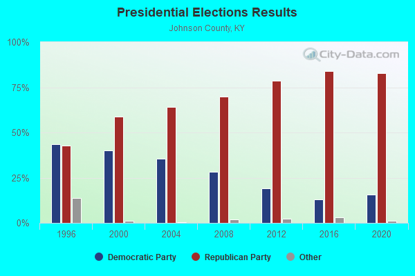
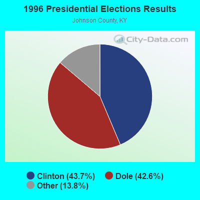
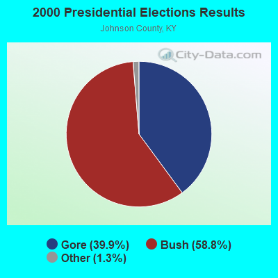

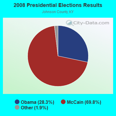
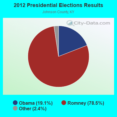

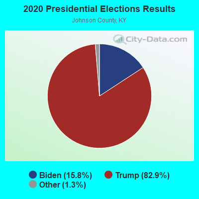
Graphs represent county-level data. Detailed 2008 Election Results
Religion statistics for Oil Springs, KY (based on Johnson County data)
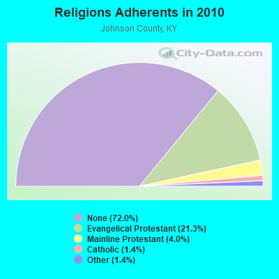
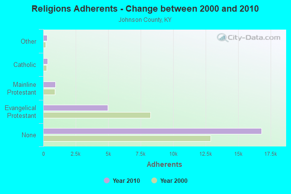
| Religion | Adherents | Congregations |
|---|---|---|
| Evangelical Protestant | 4,977 | 51 |
| Mainline Protestant | 925 | 4 |
| Catholic | 325 | 1 |
| Other | 316 | 2 |
| None | 16,813 | - |
Food Environment Statistics:
| Johnson County: | 1.67 / 10,000 pop. |
| Kentucky: | 2.19 / 10,000 pop. |
| Here: | 1.25 / 10,000 pop. |
| State: | 0.74 / 10,000 pop. |
| Johnson County: | 5.42 / 10,000 pop. |
| State: | 4.36 / 10,000 pop. |
| Here: | 5.00 / 10,000 pop. |
| State: | 5.74 / 10,000 pop. |
| Here: | 10.6% |
| State: | 11.0% |
| Here: | 36.3% |
| State: | 30.0% |
| This county: | 19.6% |
| Kentucky: | 15.9% |
Strongest AM radio stations in Oil Springs:
- WKYH (600 AM; 5 kW; PAINTSVILLE, KY; Owner: HIGHLANDS BROADCASTING CORPORATION)
- WDOC (1310 AM; 5 kW; PRESTONSBURG, KY)
- WPRT (960 AM; 5 kW; PRESTONSBURG, KY; Owner: EAST KENTUCKY RADIO NETWORK, INC.)
- WSIP (1490 AM; 1 kW; PAINTSVILLE, KY; Owner: S.I.P. BROADCASTING COMPANY, INC.)
- WLSI (900 AM; 5 kW; PIKEVILLE, KY; Owner: EAST KENTUCKY BROADCASTING CORPORATION)
- WMTC (730 AM; 5 kW; VANCLEVE, KY; Owner: THE KENTUCKY MOUNTAIN HOLINESS ASSN.)
- WRLV (1140 AM; daytime; 1 kW; SALYERSVILLE, KY; Owner: WALLINGFORD BROADCASTING COMPANY, INC)
- WEKG (810 AM; daytime; 5 kW; JACKSON, KY; Owner: INTERMOUNTAIN B/CING CO., INC.)
- WTVN (610 AM; 50 kW; COLUMBUS, OH; Owner: CITICASTERS LICENSES, L.P.)
- WLW (700 AM; 50 kW; CINCINNATI, OH; Owner: JACOR BROADCASTING CORPORATION)
- WKVL (850 AM; daytime; 50 kW; KNOXVILLE, TN; Owner: HORNE RADIO, LLC)
- WHAS (840 AM; 50 kW; LOUISVILLE, KY; Owner: CLEAR CHANNEL BROADCASTING LICENSES, INC.)
- WVHU (800 AM; 5 kW; HUNTINGTON, WV; Owner: CAPSTAR TX LIMITED PARTNERSHIP)
Strongest FM radio stations in Oil Springs:
- WKLW-FM (94.7 FM; PAINTSVILLE, KY; Owner: B & G BROADCASTING, INC.)
- WSIP-FM (98.9 FM; PAINTSVILLE, KY; Owner: SIP BROADCASTING, INC.)
- WQHY (95.5 FM; PRESTONSBURG, KY; Owner: WDOC, INC.)
- WXKZ-FM (105.3 FM; PRESTONSBURG, KY; Owner: ADAM GEARHEART D/B/A WXLR-FM)
- WRLV-FM (106.5 FM; SALYERSVILLE, KY; Owner: WALLINGFORD BROADCASTING COMPANY, INC.)
- WMDJ-FM (100.1 FM; ALLEN, KY; Owner: FLOYD COUNTY BROADCASTING CO., INC.)
- WXLR (104.9 FM; HAROLD, KY; Owner: ADAM D GEARHEART)
- WDHR (93.1 FM; PIKEVILLE, KY; Owner: EAST KENTUCKY BROADCASTING CORP.)
- WSGS (101.1 FM; HAZARD, KY; Owner: MOUNTAIN BROADCASTING SERVICE, INC.)
- WIFX-FM (94.3 FM; JENKINS, KY; Owner: LETCHER COUNTY BROADCASTING, INC)
- WXKQ-FM (103.9 FM; WHITESBURG, KY; Owner: T.C.W. BROADCASTING , INC.)
- WPKE-FM (103.1 FM; COAL RUN, KY; Owner: EAST KENTUCKY BROADCASTING CORP.)
- WZQQ (97.9 FM; HYDEN, KY; Owner: LESLIE COUNTY BROADCASTING, INC.)
- WMMT (88.7 FM; WHITESBURG, KY; Owner: APPALSHOP, INCORPORATED)
- WSEH (102.7 FM; CUMBERLAND, KY; Owner: CUMBERLAND CITY BROADCASTING, INC.)
- WDXC (102.3 FM; POUND, VA; Owner: WDXC RADIO, INC.)
- WJMD (104.7 FM; HAZARD, KY; Owner: HAZARD BROADCASTING SERVICES)
- WJSN-FM (106.5 FM; JACKSON, KY; Owner: INTERMOUNTAIN BROADCASTING CO.)
- WZLK (107.5 FM; VIRGIE, KY; Owner: EAST KENTUCKY BROADCASTING CORPORATION)
- WEKH (90.9 FM; HAZARD, KY; Owner: EASTERN KENTUCKY UNIVERSITY)
TV broadcast stations around Oil Springs:
- W26BK (Channel 26; TALBERT, KY; Owner: MS COMMUNICATIONS, LLC)
- W16BI (Channel 16; TALBERT, KY; Owner: MS COMMUNICATIONS, LLC)
- WUPX-TV (Channel 67; MOREHEAD, KY; Owner: PAXSON LEXINGTON LICENSE, INC.)
- WYMT-TV (Channel 57; HAZARD, KY; Owner: WYMT LICENSEE CORP.)

Oil Springs fatal accident list:
Feb 27, 2009 08:00 AM, Us-460, Lat: 37.805919, Lon: -82.867383, Vehicles: 2, Persons: 4, Fatalities: 3
May 29, 2006 06:48 PM, Us-460, Lat: 37.785660, Lon: -82.827530, Vehicles: 2, Persons: 2, Fatalities: 1, Drunk persons involved: 1
Jul 3, 2006 09:31 PM, Sr-1409, Lat: 37.852580, Lon: -82.966040, Vehicles: 1, Persons: 1, Fatalities: 1
Sep 14, 1992 05:15 PM, 460, Vehicles: 2, Persons: 4, Fatalities: 4
FCC Registered Cell Phone Towers:
1 (See the full list of FCC Registered Cell Phone Towers in Oil Springs)FCC Registered Antenna Towers:
12 (See the full list of FCC Registered Antenna Towers)FCC Registered Broadcast Land Mobile Towers:
1- Oil Springs Pump Sta (Lat: 37.812028 Lon: -82.910444), Type: Upole, Structure height: 6 m, Call Sign: WPRA591,
Assigned Frequencies: 173.312 MHz, Grant Date: 05/22/2015, Expiration Date: 07/25/2025, Certifier: Larry D Herald, Registrant: Micro-Comm, Inc., 15895 S. Pflumm Road, Olathe, KS 66062, Phone: (913) 390-4500, Fax: (913) 390-4550, Email:
FCC Registered Microwave Towers:
1- Stuffley Knob, Stuffley Knob, 3.5 Km Se Of (Lat: 37.782889 Lon: -82.921778), Type: Tower, Structure height: 91.4 m, Overall height: 99.1 m, Call Sign: WQFH486,
Assigned Frequencies: 6256.54 MHz, Grant Date: 07/17/2006, Expiration Date: 07/17/2016, Cancellation Date: 07/17/2013, Certifier: Gerald Robinette, Registrant: Lukas, Nace, Gutierrez & Sachs, LLP, 8300 Greensboro Drive, Mclean, VA 22102, Phone: (703) 584-8665, Fax: (703) 584-8695, Email:
FCC Registered Paging Towers:
3- Stuffley Knob, 2.5 Miles Southeast Of (Lat: 37.783417 Lon: -82.920417), Call Sign: KNKJ219,
Assigned Frequencies: 459.200 MHz, 158.100 MHz, Grant Date: 03/03/2009, Expiration Date: 04/01/2019, Cancellation Date: 03/31/2014, Certifier: Paul R Gearheart, Registrant: Lukas, Nace, Gutierrez & Sachs, LLP, 8300 Greensboro Drive, Mclean, VA 22102, Phone: (703) 584-8665, Fax: (703) 584-8695, Email:
- 2 Miles Sse Of (Lat: 37.777583 Lon: -82.918472), Call Sign: KNKL683,
Assigned Frequencies: 459.300 MHz, Expiration Date: 04/01/1999, Cancellation Date: 06/05/1999, Registrant: Gerald Delong Dba: East Kentucky Mobile Telephone Company, Pikeville, KY 41501-4336, Phone: (202) 223-4664
- 2 Miles Sse Of (Lat: 37.777583 Lon: -82.918472), Overall height: 54.9 m, Call Sign: KNKP771,
Assigned Frequencies: 931.612 MHz, Grant Date: 04/19/1999, Expiration Date: 04/01/2009, Cancellation Date: 03/26/2003, Registrant: Greenberg Traurig, 1300 Connecticut Avenue, Nw, Suite 1000, Washington, DC 20036, Phone: (202) 331-3161, Fax: (202) 331-3101, Email:
FCC Registered Amateur Radio Licenses:
7- Call Sign: KB4GER, Grant Date: 10/25/1988, Expiration Date: 10/25/1998, Cancellation Date: 10/26/2000, Registrant: Kevin B Rice, Hc60 Box 3430, Oil Springs, KY 41238
- Call Sign: KE4OEE, Licensee ID: L00879938, Grant Date: 06/17/2014, Expiration Date: 07/14/2024, Certifier: Michael A Jackson, Registrant: Michael A Jackson, 1459 Pigeon Creek Rd, Oil Springs, KY 41238
- Call Sign: KF4NVJ, Licensee ID: L01197376, Grant Date: 09/28/2006, Expiration Date: 12/11/2016, Cancellation Date: 12/12/2018, Certifier: Phillis C Jackson, Registrant: Phillis C Jackson, 1459 Pigeon Crk, Oil Springs, KY 41238
- Call Sign: KF4WRV, Licensee ID: L00320602, Grant Date: 03/31/1998, Expiration Date: 03/31/2008, Cancellation Date: 04/01/2010, Certifier: Billy R Ward, Registrant: Billy R Ward, 7099 Ky Hwy 580, Oil Springs, KY 41238
- Call Sign: WA4TGH, Grant Date: 03/08/1995, Expiration Date: 07/12/1998, Cancellation Date: 07/13/2000, Registrant: Gary S Rice, Oil Springs, KY 41238
- Call Sign: WB2VGX, Licensee ID: L00281246, Grant Date: 03/17/1999, Expiration Date: 03/17/2009, Cancellation Date: 06/28/2008, Certifier: Albert K Layton, Registrant: Albert K Layton, 8415 Ky 40 West, Oil Springs, KY 41238
- Call Sign: K2BNR, Previous Call Sign: WB2VGX, Licensee ID: L00281246, Grant Date: 06/28/2008, Expiration Date: 06/28/2018, Cancellation Date: 06/30/2020, Certifier: Albert K Layton, Registrant: Albert K Layton, 8415 Ky 40 West, Oil Springs, KY 41238
2002 - 2018 National Fire Incident Reporting System (NFIRS) incidents
- Fire incident types reported to NFIRS in Oil Springs, KY
- 5645.2%Structure Fires
- 4435.5%Outside Fires
- 1612.9%Mobile Property/Vehicle Fires
- 86.5%Other
 Based on the data from the years 2002 - 2018 the average number of fires per year is 7. The highest number of reported fire incidents - 14 took place in 2008, and the least - 2 in 2006. The data has a decreasing trend.
 When looking into fire subcategories, the most reports belonged to: Structure Fires (45.2%), and Outside Fires (35.5%).
- 58.8%Electricity
- 17.7%Bottled, tank, or LP gas
- 13.7%Utility gas
- 4.9%Coal or coke
- 3.0%Fuel oil, kerosene, etc.
- 1.9%Wood

- 67.3%Electricity
- 13.2%Bottled, tank, or LP gas
- 8.2%Wood
- 7.5%Fuel oil, kerosene, etc.
- 3.8%Utility gas
Oil Springs compared to Kentucky state average:
- Unemployed percentage below state average.
- Black race population percentage significantly below state average.
- Hispanic race population percentage significantly below state average.
- Median age below state average.
- Foreign-born population percentage significantly below state average.
- Renting percentage below state average.
- Length of stay since moving in significantly above state average.
- Number of rooms per house significantly below state average.
- House age significantly below state average.
- Percentage of population with a bachelor's degree or higher significantly below state average.