Peaks Mill, Kentucky
Submit your own pictures of this place and show them to the world
- OSM Map
- General Map
- Google Map
- MSN Map

| Males: 608 | |
| Females: 580 |
| Median resident age: | 38.7 years |
| Kentucky median age: | 35.9 years |
Zip code: 40601
| Peaks Mill: | $66,707 |
| KY: | $59,341 |
Estimated per capita income in 2022: $32,367 (it was $17,786 in 2000)
Peaks Mill CCD income, earnings, and wages data
Estimated median house or condo value in 2022: $168,833 (it was $73,800 in 2000)
| Peaks Mill: | $168,833 |
| KY: | $196,300 |
Detailed information about poverty and poor residents in Peaks Mill, KY


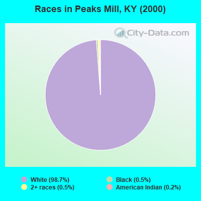
- 1,15798.7%White alone
- 60.5%Black alone
- 60.5%Two or more races
- 20.2%American Indian alone
- 10.09%Asian alone
Races in Peaks Mill detailed stats: ancestries, foreign born residents, place of birth
 Recent articles from our blog. Our writers, many of them Ph.D. graduates or candidates, create easy-to-read articles on a wide variety of topics.

Current Local Time: EST time zone
Elevation: 521 feet
Land area: 31.6 square miles.
Population density: 38 people per square mile (very low).

| Peaks Mill CCD: | 0.8% ($597) |
| Kentucky: | 0.8% ($610) |
Nearest city with pop. 50,000+: Fayette, KY  (26.1 miles , pop. 260,512).
Nearest city with pop. 1,000,000+: Chicago, IL (287.3 miles , pop. 2,896,016).
Nearest cities:
), ), ), )Latitude: 38.31 N, Longitude: 84.81 W
Area code commonly used in this area: 502

| Here: | 3.4% |
| Kentucky: | 3.8% |
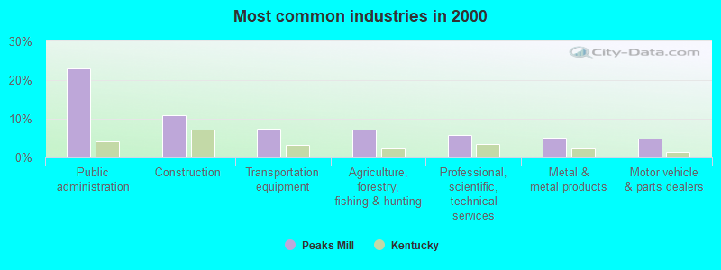
- Public administration (23.0%)
- Construction (10.9%)
- Transportation equipment (7.4%)
- Agriculture, forestry, fishing & hunting (7.2%)
- Professional, scientific, technical services (5.9%)
- Metal & metal products (5.2%)
- Motor vehicle & parts dealers (4.8%)
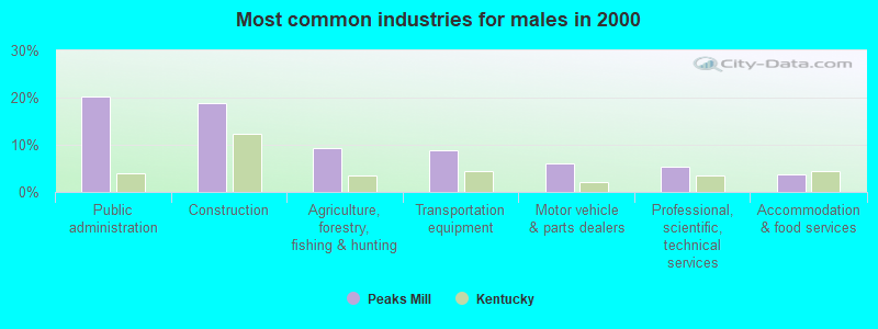
- Public administration (20.1%)
- Construction (18.8%)
- Agriculture, forestry, fishing & hunting (9.3%)
- Transportation equipment (8.9%)
- Motor vehicle & parts dealers (6.1%)
- Professional, scientific, technical services (5.4%)
- Accommodation & food services (3.8%)
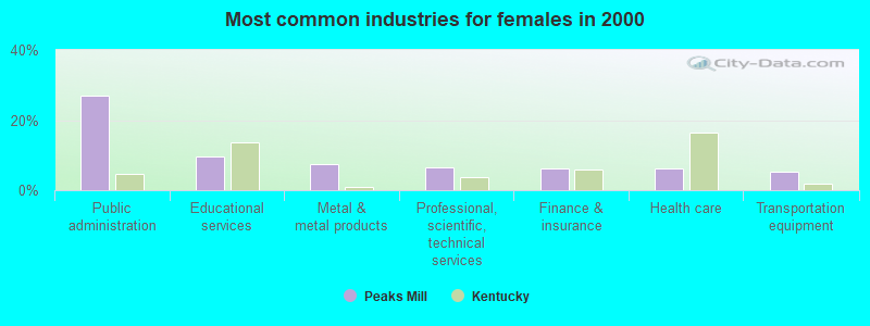
- Public administration (27.0%)
- Educational services (9.6%)
- Metal & metal products (7.4%)
- Professional, scientific, technical services (6.5%)
- Finance & insurance (6.1%)
- Health care (6.1%)
- Transportation equipment (5.2%)
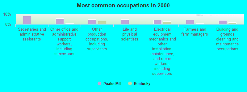
- Secretaries and administrative assistants (8.3%)
- Other office and administrative support workers, including supervisors (5.9%)
- Other production occupations, including supervisors (4.8%)
- Life and physical scientists (4.8%)
- Electrical equipment mechanics and other installation, maintenance, and repair workers, including supervisors (4.6%)
- Farmers and farm managers (4.4%)
- Building and grounds cleaning and maintenance occupations (3.9%)
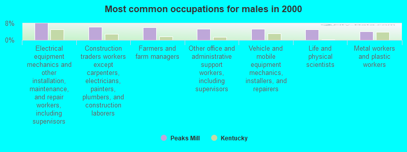
- Electrical equipment mechanics and other installation, maintenance, and repair workers, including supervisors (8.0%)
- Construction traders workers except carpenters, electricians, painters, plumbers, and construction laborers (6.4%)
- Farmers and farm managers (6.1%)
- Other office and administrative support workers, including supervisors (5.4%)
- Vehicle and mobile equipment mechanics, installers, and repairers (5.4%)
- Life and physical scientists (5.1%)
- Metal workers and plastic workers (4.2%)
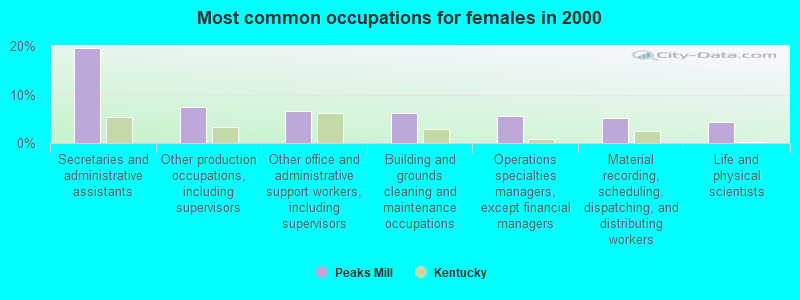
- Secretaries and administrative assistants (19.6%)
- Other production occupations, including supervisors (7.4%)
- Other office and administrative support workers, including supervisors (6.5%)
- Building and grounds cleaning and maintenance occupations (6.1%)
- Operations specialties managers, except financial managers (5.7%)
- Material recording, scheduling, dispatching, and distributing workers (5.2%)
- Life and physical scientists (4.3%)
Average climate in Peaks Mill, Kentucky
Based on data reported by over 4,000 weather stations


(lower is better)
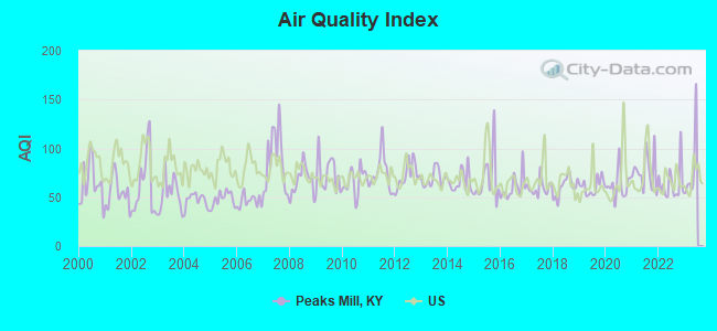
Air Quality Index (AQI) level in 2022 was 63.9. This is about average.
| City: | 63.9 |
| U.S.: | 72.6 |
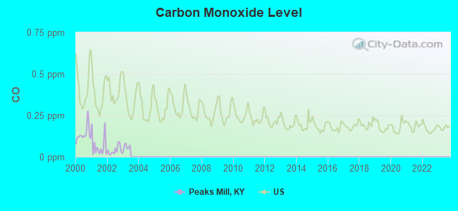
Carbon Monoxide (CO) [ppm] level in 2002 was 0.0391. This is significantly better than average. Closest monitor was 24.2 miles away from the city center.
| City: | 0.0391 |
| U.S.: | 0.2513 |
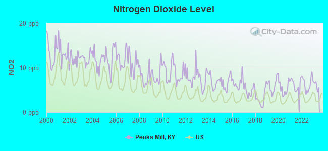
Nitrogen Dioxide (NO2) [ppb] level in 2022 was 6.38. This is worse than average. Closest monitor was 0.9 miles away from the city center.
| City: | 6.38 |
| U.S.: | 5.11 |
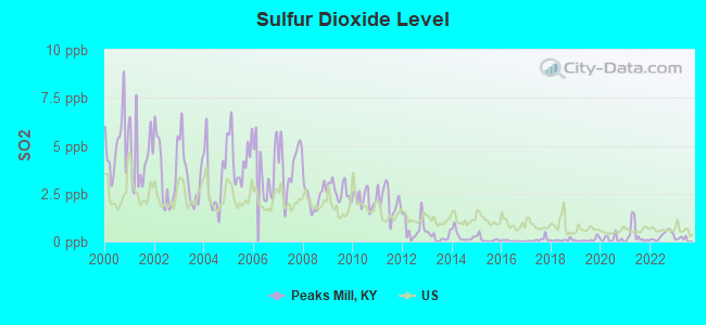
Sulfur Dioxide (SO2) [ppb] level in 2022 was 0.320. This is significantly better than average. Closest monitor was 0.9 miles away from the city center.
| City: | 0.320 |
| U.S.: | 1.515 |
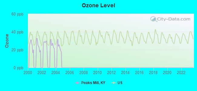
Ozone [ppb] level in 2004 was 23.6. This is significantly better than average. Closest monitor was 14.5 miles away from the city center.
| City: | 23.6 |
| U.S.: | 33.3 |
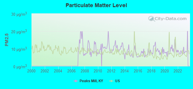
Particulate Matter (PM2.5) [µg/m3] level in 2022 was 7.97. This is about average. Closest monitor was 6.7 miles away from the city center.
| City: | 7.97 |
| U.S.: | 8.11 |
Tornado activity:
Peaks Mill-area historical tornado activity is slightly above Kentucky state average. It is 48% greater than the overall U.S. average.
On 4/3/1974, a category F4 (max. wind speeds 207-260 mph) tornado 15.9 miles away from the Peaks Mill place center killed 4 people and injured 122 people and caused between $50,000 and $500,000 in damages.
On 11/22/1992, a category F4 tornado 24.3 miles away from the place center killed one person and injured 10 people and caused between $500,000 and $5,000,000 in damages.
Earthquake activity:
Peaks Mill-area historical earthquake activity is significantly above Kentucky state average. It is 76% greater than the overall U.S. average.On 7/27/1980 at 18:52:21, a magnitude 5.2 (5.1 MB, 4.7 MS, 5.0 UK, 5.2 UK, Class: Moderate, Intensity: VI - VII) earthquake occurred 47.7 miles away from Peaks Mill center
On 4/18/2008 at 09:36:59, a magnitude 5.4 (5.1 MB, 4.8 MS, 5.4 MW, 5.2 MW) earthquake occurred 167.0 miles away from the city center
On 4/18/2008 at 09:36:59, a magnitude 5.2 (5.2 MW, Depth: 8.9 mi) earthquake occurred 167.0 miles away from Peaks Mill center
On 9/7/1988 at 02:28:09, a magnitude 4.6 (4.5 MB, 4.6 LG, Class: Light, Intensity: IV - V) earthquake occurred 52.0 miles away from the city center
On 6/10/1987 at 23:48:54, a magnitude 5.1 (4.9 MB, 4.4 MS, 4.6 MS, 5.1 LG) earthquake occurred 169.9 miles away from the city center
On 6/18/2002 at 17:37:15, a magnitude 5.0 (4.3 MB, 4.6 MW, 5.0 LG) earthquake occurred 163.1 miles away from the city center
Magnitude types: regional Lg-wave magnitude (LG), body-wave magnitude (MB), surface-wave magnitude (MS), moment magnitude (MW)
Natural disasters:
The number of natural disasters in Franklin County (18) is near the US average (15).Major Disasters (Presidential) Declared: 15
Emergencies Declared: 2
Causes of natural disasters: Floods: 12, Storms: 8, Tornadoes: 6, Mudslides: 5, Winter Storms: 5, Landslides: 3, Snowstorms: 2, Blizzard: 1, Heavy Rain: 1, Hurricane: 1, Snow: 1, Wind: 1, Other: 1 (Note: some incidents may be assigned to more than one category).
Hospitals and medical centers near Peaks Mill:
- FRANKLIN COUNTY HOME HEALTH (Home Health Center, about 9 miles away; FRANKFORT, KY)
- GOLDEN LIVINGCENTER - FRANKFORT (Nursing Home, about 11 miles away; FRANKFORT, KY)
- FRANKFORT REGIONAL MEDICAL CENTER Acute Care Hospitals (about 12 miles away; FRANKFORT, KY)
- THREE RIVERS DISTRICT HHA (Home Health Center, about 16 miles away; OWENTON, KY)
- SIGNATURE HEALTHCARE OF GEORGETOWN (Nursing Home, about 16 miles away; GEORGETOWN, KY)
- NEW HORIZONS HEALTH SYSTEMS INC (Hospital, about 16 miles away; OWENTON, KY)
- NEW HORIZONS MEDICAL CENTER Critical Access Hospitals (about 16 miles away; OWENTON, KY)
Colleges/universities with over 2000 students nearest to Peaks Mill:
- Kentucky State University (about 9 miles; Frankfort, KY; Full-time enrollment: 2,112)
- University of Kentucky (about 26 miles; Lexington, KY; FT enrollment: 23,517)
- Bluegrass Community and Technical College (about 27 miles; Lexington, KY; FT enrollment: 8,560)
- Gateway Community and Technical College (about 46 miles; Florence, KY; FT enrollment: 2,422)
- Sullivan University (about 48 miles; Louisville, KY; FT enrollment: 5,129)
- The Southern Baptist Theological Seminary (about 48 miles; Louisville, KY; FT enrollment: 2,360)
- Eastern Kentucky University (about 49 miles; Richmond, KY; FT enrollment: 13,525)
Points of interest:
Notable locations in Peaks Mill: Frankfort Fish Hatchery (A), Franklin County Fire Department Station 7 (B). Display/hide their locations on the map
Churches in Peaks Mill include: Mount Vernon Church (A), Camp Pleasant Church (B). Display/hide their locations on the map
Cemetery: Peaks Mill Church Cemetery (1). Display/hide its location on the map
Streams, rivers, and creeks: Steeles Branch (A), Pleasant Branch (B), Long Branch (C), Julius Branch (D), Claxton Branch Sulphur Lick Creek (E), Hall Branch (F), Oakland Branch (G), Gregory Branch (H), Flag Branch (I). Display/hide their locations on the map
| This place: | 2.4 people |
| Kentucky: | 2.5 people |
| This place: | 72.1% |
| Whole state: | 66.9% |
| This place: | 6.9% |
| Whole state: | 6.4% |
Likely homosexual households (counted as self-reported same-sex unmarried-partner households)
- Lesbian couples: 0.6% of all households
- Gay men: 0.2% of all households
| This place: | 2.8% |
| Whole state: | 15.8% |
| This place: | 1.2% |
| Whole state: | 6.6% |
For population 15 years and over in Peaks Mill:
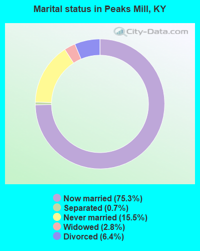
- Never married: 15.5%
- Now married: 75.3%
- Separated: 0.7%
- Widowed: 2.8%
- Divorced: 6.4%
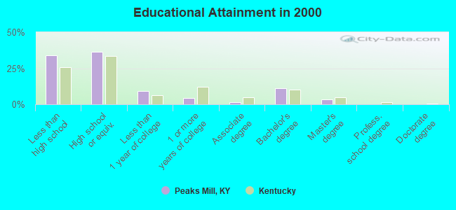
For population 25 years and over in Peaks Mill:
- High school or higher: 65.9%
- Bachelor's degree or higher: 14.8%
- Graduate or professional degree: 3.4%
- Unemployed: 3.6%
- Mean travel time to work (commute): 26.7 minutes
| Here: | 13.3 |
| Kentucky average: | 13.8 |
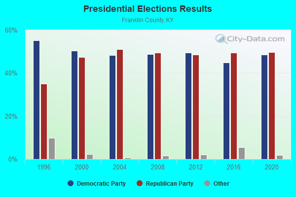
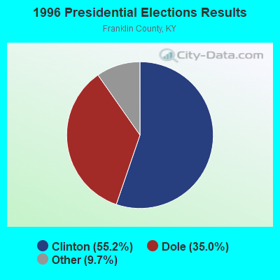
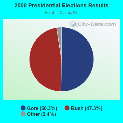
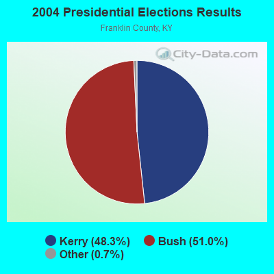

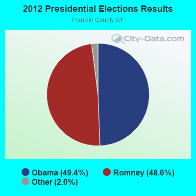
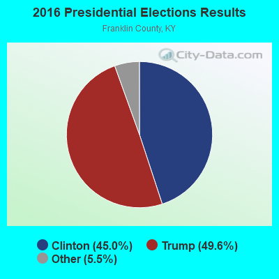
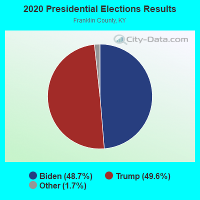
Graphs represent county-level data. Detailed 2008 Election Results
Religion statistics for Peaks Mill, KY (based on Franklin County data)
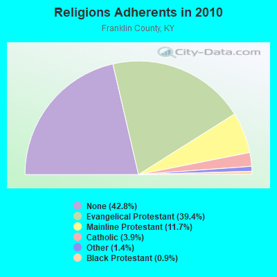
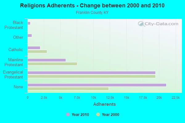
| Religion | Adherents | Congregations |
|---|---|---|
| Evangelical Protestant | 19,409 | 57 |
| Mainline Protestant | 5,783 | 13 |
| Catholic | 1,911 | 1 |
| Other | 673 | 3 |
| Black Protestant | 432 | 3 |
| None | 21,077 | - |
Food Environment Statistics:
| Franklin County: | 1.45 / 10,000 pop. |
| Kentucky: | 2.19 / 10,000 pop. |
| Franklin County: | 0.21 / 10,000 pop. |
| Kentucky: | 0.25 / 10,000 pop. |
| Franklin County: | 1.03 / 10,000 pop. |
| State: | 0.74 / 10,000 pop. |
| Franklin County: | 4.75 / 10,000 pop. |
| Kentucky: | 4.36 / 10,000 pop. |
| Franklin County: | 6.61 / 10,000 pop. |
| State: | 5.74 / 10,000 pop. |
| This county: | 11.5% |
| Kentucky: | 11.0% |
| Here: | 31.8% |
| Kentucky: | 30.0% |
| Franklin County: | 21.4% |
| Kentucky: | 15.9% |
Strongest AM radio stations in Peaks Mill:
- WHAS (840 AM; 50 kW; LOUISVILLE, KY; Owner: CLEAR CHANNEL BROADCASTING LICENSES, INC.)
- WXRA (1580 AM; 10 kW; GEORGETOWN, KY; Owner: CITICASTERS LICENSES, L.P.)
- WVLK (590 AM; 5 kW; LEXINGTON, KY; Owner: CUMULUS LICENSING CORP.)
- WLAP (630 AM; 5 kW; LEXINGTON, KY; Owner: CITICASTERS LICENSES, L.P.)
- WSAI (1530 AM; 50 kW; CINCINNATI, OH; Owner: JACOR BROADCASTING CORPORATION)
- WLW (700 AM; 50 kW; CINCINNATI, OH; Owner: JACOR BROADCASTING CORPORATION)
- WFKY (1490 AM; 1 kW; FRANKFORT, KY; Owner: CLEAR CHANNEL BROADCASTING LICENSES, INC.)
- WLXG (1300 AM; 2 kW; LEXINGTON, KY; Owner: L.M. COMMUNICATIONS, INC)
- WTVN (610 AM; 50 kW; COLUMBUS, OH; Owner: CITICASTERS LICENSES, L.P.)
- WXXA (790 AM; 5 kW; LOUISVILLE, KY)
- WKRC (550 AM; 5 kW; CINCINNATI, OH; Owner: JACOR BROADCASTING CORPORATION)
- WKJK (1080 AM; 10 kW; LOUISVILLE, KY; Owner: CLEAR CHANNEL BROADCASTING LICENSES, INC.)
- WIBC (1070 AM; 50 kW; INDIANAPOLIS, IN; Owner: EMMIS RADIO LICENSE CORPORATION)
Strongest FM radio stations in Peaks Mill:
- WKED-FM (103.7 FM; FRANKFORT, KY; Owner: CLEAR CHANNEL BROADCASTING LICENSES, INC.)
- WKYW (104.9 FM; FRANKFORT, KY; Owner: CLEAR CHANNEL BROADCASTING LICENSES, INC.)
- W202AZ (88.3 FM; FRANKFORT, KY; Owner: BIBLE BROADCASTING NETWORK, INC.)
- WUKY (91.3 FM; LEXINGTON, KY; Owner: BD. OF TRUSTEES UNIV. OF KENTUCKY)
- WBTF (107.9 FM; MIDWAY, KY; Owner: L.M. COMMUNICATIONS OF KENTUCKY, LLC)
- WLXO (96.1 FM; STAMPING GROUND, KY; Owner: CLARITY COMMUNICATIONS, INC.)
- WRVG-FM (89.9 FM; GEORGETOWN, KY; Owner: GEORGETOWN COLLEGE)
- WVLK-FM (92.9 FM; LEXINGTON, KY; Owner: CUMULUS LICENSING CORP.)
- WKQQ (100.1 FM; WINCHESTER, KY; Owner: CITICASTERS LICENSES, L.P.)
- WMXL (94.5 FM; LEXINGTON, KY; Owner: CITICASTERS LICENSES, INC.)
- WXZZ (103.3 FM; GEORGETOWN, KY; Owner: CUMULUS LICENSING CORP.)
- WIOK (107.5 FM; FALMOUTH, KY; Owner: HAMMOND BROADCASTING, INC.)
- WBUL-FM (98.1 FM; LEXINGTON, KY; Owner: CITICASTERS LICENSES, L.P.)
- WKYL (102.1 FM; LAWRENCEBURG, KY; Owner: DAVENPORT BROADCASTING, INC.)
- WNKR (106.5 FM; WILLIAMSTOWN, KY; Owner: GRANT COUNTY BROADCASTERS, INC)
- WJMM-FM (99.3 FM; HARRODSBURG, KY; Owner: MORTENSON BROADCASTING COMPANY OF CENTRAL KENTUCKY, LLC)
- WTSZ-FM (105.7 FM; EMINENCE, KY; Owner: METRO EAST CBC, INC.)
- WGKS (96.9 FM; PARIS, KY; Owner: L.M. COMMUNICATIONS, INC.)
- WCDA (106.3 FM; VERSAILLES, KY; Owner: L.M. COMMUNICATIONS, INC)
- WJZO (101.7 FM; SHELBYVILLE, KY; Owner: CLEAR CHANNEL BROADCASTING LICENSES, INC.)
TV broadcast stations around Peaks Mill:
- WAVE (Channel 3; LOUISVILLE, KY; Owner: LIBCO, INC.)
- WKON (Channel 52; OWENTON, KY; Owner: KENTUCKY AUTHORITY FOR EDUCATIONAL TV)
- WKYT-TV (Channel 27; LEXINGTON, KY; Owner: WKYT LICENSEE CORP.)
- WTVQ-TV (Channel 36; LEXINGTON, KY; Owner: MEDIA GENERAL COMMUNICATIONS, INC.)
- WDKY-TV (Channel 56; DANVILLE, KY; Owner: WDKY LICENSEE, LLC)
- W24BW (Channel 24; LOUISVILLE, KY; Owner: GREATER LOUISVILLE COMMUNICATIONS)
- WKLE (Channel 46; LEXINGTON, KY; Owner: KENTUCKY AUTHORITY FOR EDUCATIONAL TV)
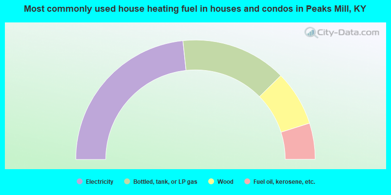
- 46.6%Electricity
- 28.6%Bottled, tank, or LP gas
- 14.9%Wood
- 9.8%Fuel oil, kerosene, etc.
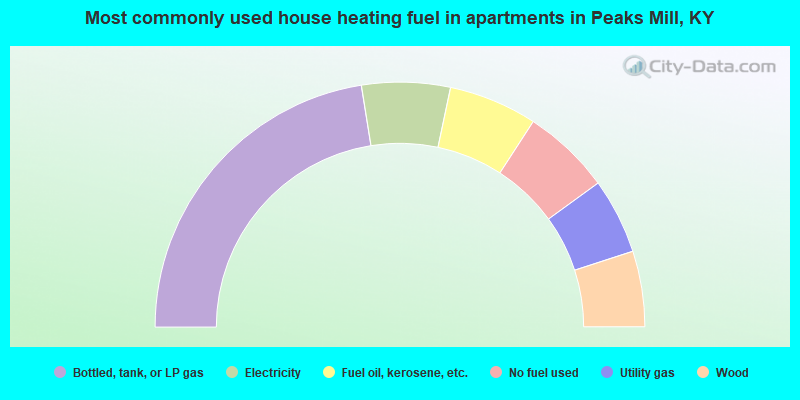
- 45.0%Bottled, tank, or LP gas
- 11.7%Electricity
- 11.7%Fuel oil, kerosene, etc.
- 11.7%No fuel used
- 10.0%Utility gas
- 10.0%Wood
Peaks Mill compared to Kentucky state average:
- Unemployed percentage significantly below state average.
- Black race population percentage significantly below state average.
- Hispanic race population percentage significantly below state average.
- Foreign-born population percentage significantly below state average.
- Renting percentage below state average.
- Length of stay since moving in significantly above state average.
- Number of rooms per house significantly below state average.
- House age significantly below state average.