Prairie Hill, Texas
Submit your own pictures of this place and show them to the world
- OSM Map
- General Map
- Google Map
- MSN Map

| Males: 389 | |
| Females: 405 |
| Median resident age: | 41.4 years |
| Texas median age: | 32.3 years |
Zip code: 76678
| Prairie Hill: | $58,571 |
| TX: | $72,284 |
Estimated per capita income in 2022: $29,266 (it was $15,609 in 2000)
Prairie Hill CCD income, earnings, and wages data
Estimated median house or condo value in 2022: $206,437 (it was $61,400 in 2000)
| Prairie Hill: | $206,437 |
| TX: | $275,400 |
Detailed information about poverty and poor residents in Prairie Hill, TX
Compare current foreclosures near Prairie Hill, TX:
| Photo | Address | Area | Beds / Baths | Price | Details |
|---|---|---|---|---|---|

|
#1
Highway 84 W # A
Prairie Hill, TX 76678
|
2,940 sq. feet
|
1 baths - beds |
show details | |

|
#2
Lcr 318
Mart, TX 76664
|
- sq. feet
|
2 baths 3 beds |
show details | |

|
#3
Highway 164 W
Mart, TX 76664
|
1,381 sq. feet
|
1 baths 3 beds |
show details | |

|
#4
Pavelka Dr
Mart, TX 76664
|
1,975 sq. feet
|
2 baths - beds |
show details | |

|
#5
Gerhardt St
Riesel, TX 76682
|
2,041 sq. feet
|
- baths 3 beds |
show details | |

|
#6
S Hedwig St
Riesel, TX 76682
|
1,612 sq. feet
|
2 baths - beds |
show details | |

|
#7
Hcr 3212
Penelope, TX 76676
|
- sq. feet
|
- baths - beds |
show details | |

|
#8
N Baese Rd
West, TX 76691
|
1,370 sq. feet
|
1 baths - beds |
show details | |

|
#9
Lcr 379
Mexia, TX 76667
|
- sq. feet
|
- baths - beds |
show details | |

|
#10
S Live Oak Ave
Hubbard, TX 76648
|
- sq. feet
|
- baths - beds |
show details |
| Photo | Address | Area | Beds / Baths | Price | Details |
|---|---|---|---|---|---|

|
#11
Private Road 330
Hubbard, TX 76648
|
980 sq. feet
|
- baths - beds |
show details | |

|
#12
Lcr 641
Groesbeck, TX 76642
|
- sq. feet
|
- baths - beds |
show details | |

|
#13
Fm 638
Dawson, TX 76639
|
- sq. feet
|
- baths - beds |
show details | |

|
#14
Cottonwood Rd
Abbott, TX 76621
|
- sq. feet
|
- baths - beds |
show details | |

|
#15
Private Road 335
Hubbard, TX 76648
|
- sq. feet
|
- baths - beds |
show details | |

|
#16
NE 5th St
Hubbard, TX 76648
|
- sq. feet
|
- baths - beds |
show details | |

|
Check over 1 million property listings on Foreclosure.com!
|
browse all offers | |||

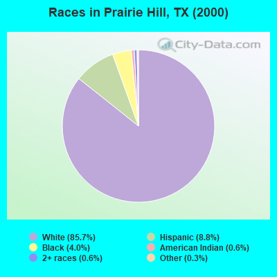
- 67085.7%White alone
- 698.8%Hispanic
- 314.0%Black alone
- 50.6%American Indian alone
- 50.6%Two or more races
- 20.3%Other race alone
Races in Prairie Hill detailed stats: ancestries, foreign born residents, place of birth
According to our research of Texas and other state lists, there was 1 registered sex offender living in Prairie Hill, Texas as of April 25, 2024.
The ratio of all residents to sex offenders in Prairie Hill is 794 to 1.
The ratio of registered sex offenders to all residents in this city is lower than the state average.
 Recent articles from our blog. Our writers, many of them Ph.D. graduates or candidates, create easy-to-read articles on a wide variety of topics.

Current Local Time: CST time zone
Land area: 140.7 square miles.
Population density: 5.6 people per square mile (very low).

| Prairie Hill CCD: | 0.6% ($376) |
| Texas: | 1.8% ($1,393) |
Nearest city with pop. 50,000+: Waco, TX  (22.5 miles , pop. 113,726).
Nearest city with pop. 200,000+: Arlington, TX (74.9 miles , pop. 332,969).
Nearest city with pop. 1,000,000+: Dallas, TX (78.9 miles , pop. 1,188,580).
Nearest cities:
), ), ), ), )Latitude: 31.66 N, Longitude: 96.80 W
Area code: 254

| Here: | 4.0% |
| Texas: | 3.5% |
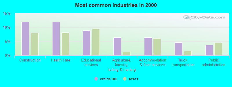
- Construction (12.0%)
- Health care (12.0%)
- Educational services (8.9%)
- Agriculture, forestry, fishing & hunting (6.5%)
- Accommodation & food services (6.5%)
- Truck transportation (4.6%)
- Public administration (3.7%)
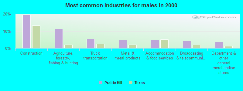
- Construction (19.5%)
- Agriculture, forestry, fishing & hunting (11.4%)
- Truck transportation (5.4%)
- Metal & metal products (4.9%)
- Accommodation & food services (4.9%)
- Broadcasting & telecommunications (4.3%)
- Department & other general merchandise stores (3.8%)
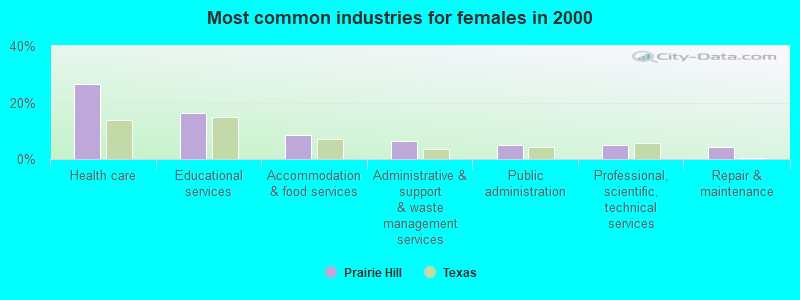
- Health care (26.4%)
- Educational services (16.4%)
- Accommodation & food services (8.6%)
- Administrative & support & waste management services (6.4%)
- Public administration (5.0%)
- Professional, scientific, technical services (5.0%)
- Repair & maintenance (4.3%)
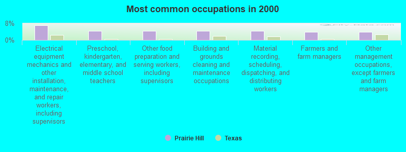
- Electrical equipment mechanics and other installation, maintenance, and repair workers, including supervisors (7.1%)
- Preschool, kindergarten, elementary, and middle school teachers (4.3%)
- Other food preparation and serving workers, including supervisors (4.3%)
- Building and grounds cleaning and maintenance occupations (4.3%)
- Material recording, scheduling, dispatching, and distributing workers (4.3%)
- Farmers and farm managers (4.0%)
- Other management occupations, except farmers and farm managers (4.0%)
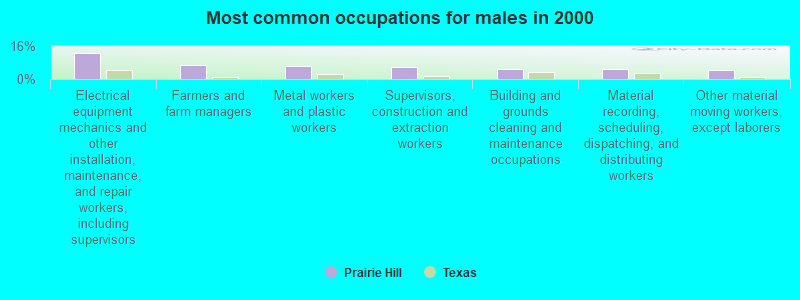
- Electrical equipment mechanics and other installation, maintenance, and repair workers, including supervisors (12.4%)
- Farmers and farm managers (7.0%)
- Metal workers and plastic workers (6.5%)
- Supervisors, construction and extraction workers (5.9%)
- Building and grounds cleaning and maintenance occupations (4.9%)
- Material recording, scheduling, dispatching, and distributing workers (4.9%)
- Other material moving workers, except laborers (4.3%)

- Preschool, kindergarten, elementary, and middle school teachers (10.0%)
- Registered nurses (7.9%)
- Health technologists and technicians (7.1%)
- Other office and administrative support workers, including supervisors (7.1%)
- Other management occupations, except farmers and farm managers (5.0%)
- Other food preparation and serving workers, including supervisors (5.0%)
- Cooks and food preparation workers (5.0%)
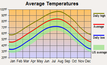
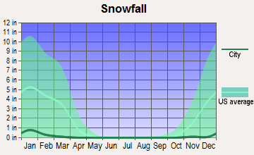
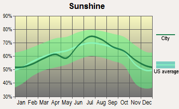
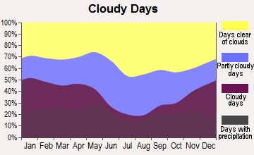
Average climate in Prairie Hill, Texas
Based on data reported by over 4,000 weather stations
(lower is better)
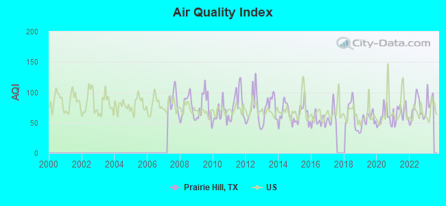
Air Quality Index (AQI) level in 2022 was 71.7. This is about average.
| City: | 71.7 |
| U.S.: | 72.6 |
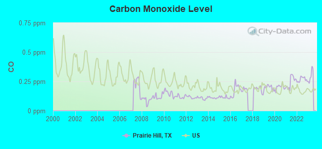
Carbon Monoxide (CO) [ppm] level in 2022 was 0.267. This is about average. Closest monitor was 16.2 miles away from the city center.
| City: | 0.267 |
| U.S.: | 0.251 |
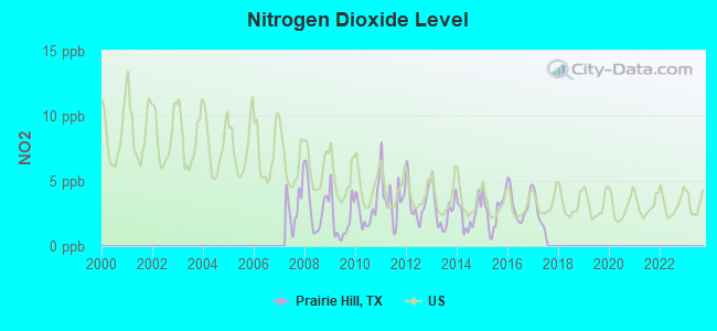
Nitrogen Dioxide (NO2) [ppb] level in 2017 was 2.33. This is significantly better than average. Closest monitor was 16.2 miles away from the city center.
| City: | 2.33 |
| U.S.: | 5.11 |
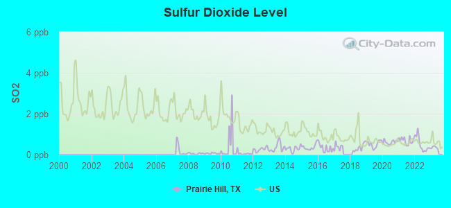
Sulfur Dioxide (SO2) [ppb] level in 2022 was 0.494. This is significantly better than average. Closest monitor was 16.2 miles away from the city center.
| City: | 0.494 |
| U.S.: | 1.515 |
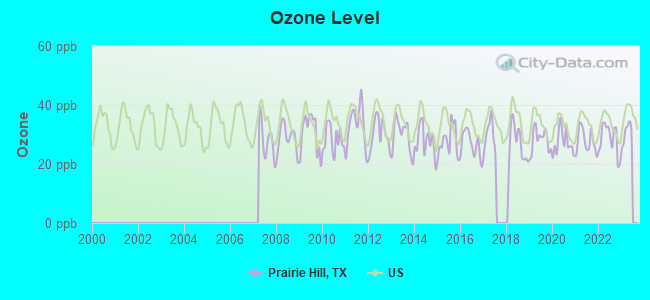
Ozone [ppb] level in 2022 was 28.5. This is about average. Closest monitor was 16.2 miles away from the city center.
| City: | 28.5 |
| U.S.: | 33.3 |
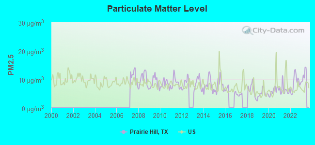
Particulate Matter (PM2.5) [µg/m3] level in 2022 was 8.80. This is about average. There were 0 monitors within city limits.
| City: | 8.80 |
| U.S.: | 8.11 |
Tornado activity:
Prairie Hill-area historical tornado activity is slightly above Texas state average. It is 82% greater than the overall U.S. average.
On 5/11/1953, a category F5 (max. wind speeds 261-318 mph) tornado 8.0 miles away from the Prairie Hill place center killed 114 people and injured 597 people and caused between $5,000,000 and $50,000,000 in damages.
On 3/10/1973, a category F4 (max. wind speeds 207-260 mph) tornado 9.1 miles away from the place center killed 6 people and injured 77 people.
Earthquake activity:
Prairie Hill-area historical earthquake activity is significantly above Texas state average. It is 339% greater than the overall U.S. average.On 11/6/2011 at 03:53:10, a magnitude 5.7 (5.7 MW, Depth: 3.2 mi, Class: Moderate, Intensity: VI - VII) earthquake occurred 267.9 miles away from Prairie Hill center
On 9/3/2016 at 12:02:44, a magnitude 5.8 (5.8 MW, Depth: 3.5 mi) earthquake occurred 329.8 miles away from the city center
On 5/17/2012 at 08:12:00, a magnitude 4.8 (4.8 MW, Depth: 3.1 mi, Class: Light, Intensity: IV - V) earthquake occurred 143.9 miles away from the city center
On 6/16/1978 at 11:46:54, a magnitude 5.3 (4.4 MB, 4.6 UK, 5.3 ML) earthquake occurred 250.6 miles away from the city center
On 10/20/2011 at 12:24:41, a magnitude 4.8 (4.8 MW, Depth: 3.1 mi) earthquake occurred 207.9 miles away from Prairie Hill center
On 5/7/2015 at 22:58:05, a magnitude 4.0 (4.0 MW, Depth: 1.6 mi) earthquake occurred 59.7 miles away from Prairie Hill center
Magnitude types: body-wave magnitude (MB), local magnitude (ML), moment magnitude (MW)
Natural disasters:
The number of natural disasters in Limestone County (13) is near the US average (15).Major Disasters (Presidential) Declared: 6
Emergencies Declared: 6
Causes of natural disasters: Floods: 4, Storms: 4, Tornadoes: 4, Fires: 3, Hurricanes: 3, Wind: 1, Other: 2 (Note: some incidents may be assigned to more than one category).
Colleges/universities with over 2000 students nearest to Prairie Hill:
- Texas State Technical College-Waco (about 18 miles; Waco, TX; Full-time enrollment: 4,210)
- Baylor University (about 21 miles; Waco, TX; FT enrollment: 14,800)
- McLennan Community College (about 23 miles; Waco, TX; FT enrollment: 6,673)
- Hill College (about 30 miles; Hillsboro, TX; FT enrollment: 2,968)
- Navarro College (about 34 miles; Corsicana, TX; FT enrollment: 7,711)
- Temple College (about 53 miles; Temple, TX; FT enrollment: 3,796)
- University of Mary Hardin-Baylor (about 57 miles; Belton, TX; FT enrollment: 2,885)
Points of interest:
Notable location: Prairie Hill Volunteer Fire Department (A). Display/hide its location on the map
Churches in Prairie Hill include: Billington Church (A), Frosa Chapel (B), Mount Antioch Church (C), Mustang Chapel (D). Display/hide their locations on the map
Cemeteries: Billington Cemetery (1), Shead Cemetery (2), Mount Calm Cemetery (3), Prairie Hill Cemetery (4), Delia Cemetery (5). Display/hide their locations on the map
Streams, rivers, and creeks: Board Creek (A), Barger Branch (B), Packwood Creek (C), Christmas Creek (D), Pin Oak Creek (E), Mustang Creek (F). Display/hide their locations on the map
Birthplace of: Nell O'Day - Actress.
| This place: | 2.6 people |
| Texas: | 2.8 people |
| This place: | 76.0% |
| Whole state: | 69.9% |
| This place: | 7.4% |
| Whole state: | 6.0% |
Likely homosexual households (counted as self-reported same-sex unmarried-partner households)
- Lesbian couples: 0.3% of all households
- Gay men: 1.2% of all households
| This place: | 17.7% |
| Whole state: | 15.4% |
| This place: | 3.1% |
| Whole state: | 6.7% |
For population 15 years and over in Prairie Hill:
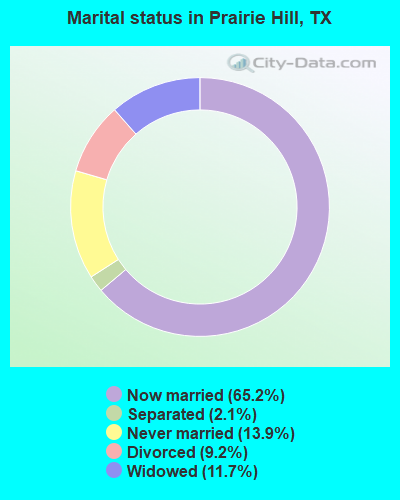
- Never married: 13.9%
- Now married: 65.2%
- Separated: 2.1%
- Widowed: 11.7%
- Divorced: 9.2%
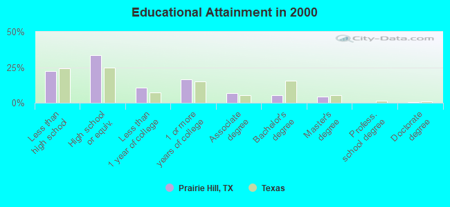
For population 25 years and over in Prairie Hill:
- High school or higher: 77.6%
- Bachelor's degree or higher: 10.2%
- Graduate or professional degree: 4.8%
- Unemployed: 3.3%
- Mean travel time to work (commute): 28.0 minutes
| Here: | 11.4 |
| Texas average: | 15.6 |
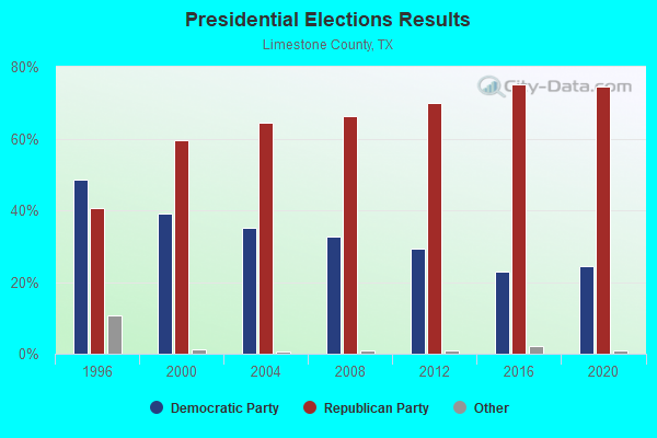
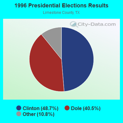

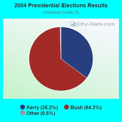
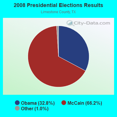
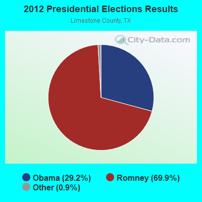
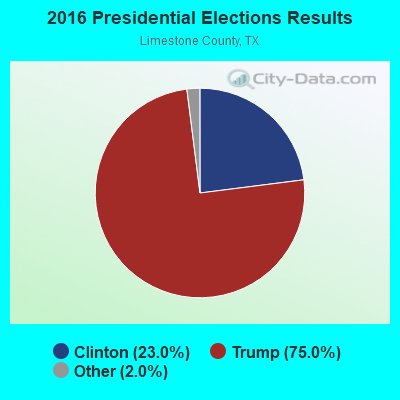
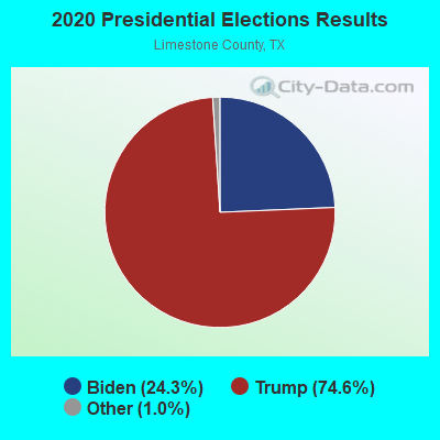
Graphs represent county-level data. Detailed 2008 Election Results
Religion statistics for Prairie Hill, TX (based on Limestone County data)
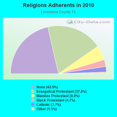
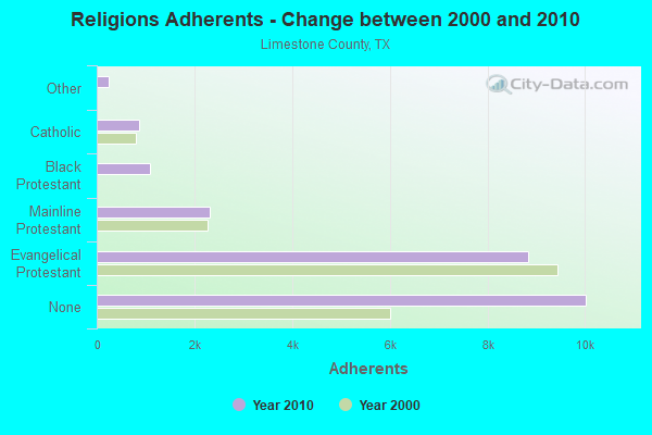
| Religion | Adherents | Congregations |
|---|---|---|
| Evangelical Protestant | 8,830 | 52 |
| Mainline Protestant | 2,314 | 13 |
| Black Protestant | 1,098 | 7 |
| Catholic | 865 | 1 |
| Other | 254 | 2 |
| None | 10,023 | - |
Food Environment Statistics:
| This county: | 2.69 / 10,000 pop. |
| Texas: | 1.47 / 10,000 pop. |
| Limestone County: | 0.45 / 10,000 pop. |
| Texas: | 0.14 / 10,000 pop. |
| Limestone County: | 1.34 / 10,000 pop. |
| Texas: | 1.11 / 10,000 pop. |
| Limestone County: | 9.41 / 10,000 pop. |
| State: | 3.95 / 10,000 pop. |
| Limestone County: | 8.52 / 10,000 pop. |
| Texas: | 6.13 / 10,000 pop. |
| This county: | 10.3% |
| Texas: | 8.9% |
| Limestone County: | 28.3% |
| Texas: | 26.6% |
| Here: | 13.5% |
| Texas: | 15.7% |
Strongest AM radio stations in Prairie Hill:
- KBBW (1010 AM; 10 kW; WACO-MARLIN, TX; Owner: AMERICAN BROADCASTING OF TEXAS)
- KRZI (1580 AM; 10 kW; WACO, TX; Owner: VAN D. GOODALL, JR.)
- WBAP (820 AM; 50 kW; FORT WORTH, TX; Owner: WBAP-KSCS OPERATING, LTD.)
- KRZX (1660 AM; 10 kW; WACO, TX; Owner: VAN D. GOODALL, JR.)
- KESS (1270 AM; 50 kW; FORT WORTH, TX; Owner: KESS-AM LICENSE CORP.)
- KRLD (1080 AM; 50 kW; DALLAS, TX; Owner: TEXAS INFINITY BROADCASTING L.P.)
- KFXR (1190 AM; 50 kW; DALLAS, TX; Owner: CLEAR CHANNEL BROADCASTING LICENSES, INC.)
- KAHZ (1360 AM; 50 kW; HURST, TX)
- KZMP (1540 AM; 50 kW; UNIVERSITY PARK, TX; Owner: ENTRAVISION HOLDINGS, LLC)
- KSKY (660 AM; 20 kW; BALCH SPRINGS, TX; Owner: BISON MEDIA, INC.)
- KBIS (1150 AM; 25 kW; HIGHLAND PARK, TX; Owner: DALLAS AM RADIO PARTNERS, L.P.)
- KTRH (740 AM; 50 kW; HOUSTON, TX; Owner: AMFM TEXAS LICENSES LIMITED PARTNERSHIP)
- KGOL (1180 AM; 50 kW; HUMBLE, TX; Owner: ENTRAVISION HOLDINGS, LLC)
Strongest FM radio stations in Prairie Hill:
- WACO-FM (99.9 FM; WACO, TX; Owner: CAPSTAR TX LIMITED PARTNERSHIP)
- KDOS (107.9 FM; ROBINSON, TX; Owner: KICI-FM LICENSE CORP.)
- KWTX-FM (97.5 FM; WACO, TX; Owner: CAPSTAR TX LIMITED PARTNERSHIP)
- KYCX-FM (104.9 FM; MEXIA, TX; Owner: MJ COMMUNICATIONS, INC.)
- KBGO (95.7 FM; WACO, TX; Owner: CAPSTAR TX LIMITED PARTNERSHIP)
- KBCT (94.5 FM; WACO, TX; Owner: KENNELWOOD BCST/G COMPANY, INC.)
- KBRQ (102.5 FM; HILLSBORO, TX; Owner: CHASE RADIO PROPERTIES, L.L.C.)
- KWBU-FM (103.3 FM; WACO, TX; Owner: BRAZOS VALLEY PUBLIC BROADCASTING FOUNDATION)
- KLRK (92.9 FM; MARLIN, TX; Owner: VAN D. GOODALL, JR.)
TV broadcast stations around Prairie Hill:
- KCEN-TV (Channel 6; TEMPLE, TX; Owner: CHANNEL 6, INC.)
- KWBU-TV (Channel 34; WACO, TX; Owner: BRAZOS VALLEY PUBLIC BROADCASTING FOUNDATION)
- KXXV (Channel 25; WACO, TX; Owner: CENTEX TELEVISION LIMITED PARTNERSHIP)
- KWKT (Channel 44; WACO, TX; Owner: COMCORP OF TEXAS LICENSE CORP.)
- KWTX-TV (Channel 10; WACO, TX; Owner: KWTX-KBTX LICENSEE CORP.)
- KSEX-LP (Channel 57; DALLAS, TX; Owner: COMMERCIAL BROADCASTING CORP.)
- KNAV-LP (Channel 30; CORSICANA, TX; Owner: NAVARRO COLLEGE)
FCC Registered Cell Phone Towers:
2 (See the full list of FCC Registered Cell Phone Towers in Prairie Hill)FCC Registered Antenna Towers:
46 (See the full list of FCC Registered Antenna Towers)FCC Registered Broadcast Land Mobile Towers:
1- 2.1 Mi N On Hwy 737 (Lat: 31.674889 Lon: -96.814444), Type: Tower, Structure height: 86 m, Call Sign: KNDE351,
Assigned Frequencies: 462.525 MHz, 462.525 MHz, Grant Date: 05/05/2022, Expiration Date: 07/30/2032, Certifier: Dennis Skruhak, Registrant: Keller And Heckman LLP, 1001 G Street Nw, Suite 500 West, Washington, DC 20001, Phone: (202) 434-4100, Fax: (202) 434-4646, Email:
FCC Registered Microwave Towers:
5- US 84/ECHOLS, 1677 Lcr 180 (Lat: 31.690083 Lon: -96.663833), Type: Gtower, Structure height: 86.6 m, Overall height: 89 m, Call Sign: WQRL630,
Assigned Frequencies: 6197.24 MHz, 6197.24 MHz, 6226.89 MHz, Grant Date: 05/09/2023, Expiration Date: 06/12/2033, Certifier: John Monday, Registrant: At&t Services, Inc., 208 S Akard St, 20f, Dallas, TX 75202, Phone: (855) 699-7073, Email:
- PRAIRIE HILL, 9646 State Highway 84 West (Lat: 31.652389 Lon: -96.774778), Type: Ltower, Structure height: 70.1 m, Overall height: 73.8 m, Call Sign: WQZG240, Licensee ID: L00004077,
Assigned Frequencies: 6063.80 MHz, 6034.15 MHz, 6063.80 MHz, 6034.15 MHz, 6063.80 MHz, 6034.15 MHz, 6063.80 MHz, 6034.15 MHz, Grant Date: 05/06/2017, Expiration Date: 05/06/2027, Certifier: Charles Derrick, Registrant: Brazos Electric Power Cooperative Inc, 7616 Bagby Ave, Waco, TX 76712, Phone: (254) 750-6385, Fax: (254) 750-6590, Email:
- PRAIRIEHILL, Fm 73, Lcr 135, Rt 1 (Lat: 31.657583 Lon: -96.779722), Type: Gtower, Structure height: 73.2 m, Overall height: 82.3 m, Call Sign: WRCY203,
Assigned Frequencies: 5960.02 MHz, 5960.02 MHz, 5960.02 MHz, 5960.02 MHz, 5960.02 MHz, 5960.02 MHz, 5960.02 MHz, 5960.02 MHz, 5960.02 MHz, 5960.02 MHz... (+45 more), Grant Date: 02/25/2019, Expiration Date: 02/25/2029, Certifier: Derrick Brown, Registrant: Amg Technology Investment Group, LLC, 95 Parker Oaks Lane, Hudson Oaks, TX 76087, Phone: (855) 698-5465, Email:
- WA02064A, Fm 73, Lcr 135, Rt 1 (Lat: 31.657583 Lon: -96.779722), Type: Ltower, Structure height: 73.2 m, Overall height: 82.3 m, Call Sign: WSBQ355,
Assigned Frequencies: 11155.0 MHz, 11155.0 MHz, 11155.0 MHz, 11155.0 MHz, 11155.0 MHz, 11155.0 MHz, 11155.0 MHz, 11155.0 MHz, 11155.0 MHz, 11155.0 MHz... (+4 more), Grant Date: 03/05/2024, Expiration Date: 03/05/2034, Certifier: Jenny Knopf, Registrant: T-Mobile Usa, Inc., 12920 Se 38th Street, Bellevue, WA 98006, Phone: (425) 383-8401, Fax: (425) 383-4040, Email:
- STATION, On Hwy 339 3.7 Mi N Of (Lat: 31.674861 Lon: -96.814417), Overall height: 86 m, Call Sign: WGX751,
Assigned Frequencies: 6825.00 MHz, 6805.00 MHz, 6004.50 MHz, 6093.45 MHz, Grant Date: 10/30/2019, Expiration Date: 12/20/2029, Certifier: Dennis Skruhak, Registrant: Keller And Heckman LLP, 1001 G Street Nw, Suite 500 West, Washington, DC 20001, Phone: (202) 434-4100, Fax: (202) 434-4646, Email:
FCC Registered Amateur Radio Licenses:
4- Call Sign: KD5OZ, Previous Call Sign: WA4NYJ, Grant Date: 03/30/1993, Expiration Date: 03/30/2003, Cancellation Date: 03/31/2005, Registrant: James H Finch, 85 Meadows Rd Rt 1, Prairie Hill, TX 76678
- Call Sign: KE5FDQ, Licensee ID: L01029182, Grant Date: 06/13/2005, Expiration Date: 06/13/2015, Cancellation Date: 03/03/2011, Certifier: Glenn N Finch, Registrant: Glenn N Finch, 970 Lcr 324, Prairie Hill, TX 76678-1216
- Call Sign: KE5FDR, Licensee ID: L00641056, Grant Date: 06/13/2005, Expiration Date: 06/13/2015, Cancellation Date: 03/03/2011, Certifier: James H Finch, Registrant: James H Finch, 970 Lcr 324, Prairie Hill, TX 76678
- Call Sign: AE5WP, Previous Call Sign: KE5FDR, Licensee ID: L00641056, Grant Date: 06/13/2005, Expiration Date: 06/13/2015, Cancellation Date: 06/14/2017, Certifier: James H Finch, Registrant: James H Finch, 970 Lcr 324, Prairie Hill, TX 76678
2002 - 2018 National Fire Incident Reporting System (NFIRS) incidents
- Fire incident types reported to NFIRS in Prairie Hill, TX
- 10281.6%Outside Fires
- 129.6%Mobile Property/Vehicle Fires
- 64.8%Other
- 54.0%Structure Fires
 Based on the data from the years 2002 - 2018 the average number of fires per year is 7. The highest number of reported fires - 24 took place in 2005, and the least - 0 in 2012. The data has a dropping trend.
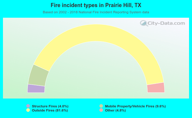 When looking into fire subcategories, the most reports belonged to: Outside Fires (81.6%), and Mobile Property/Vehicle Fires (9.6%).
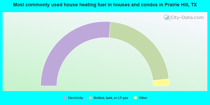
- 52.7%Electricity
- 43.8%Bottled, tank, or LP gas
- 2.0%Wood
- 1.6%Other fuel
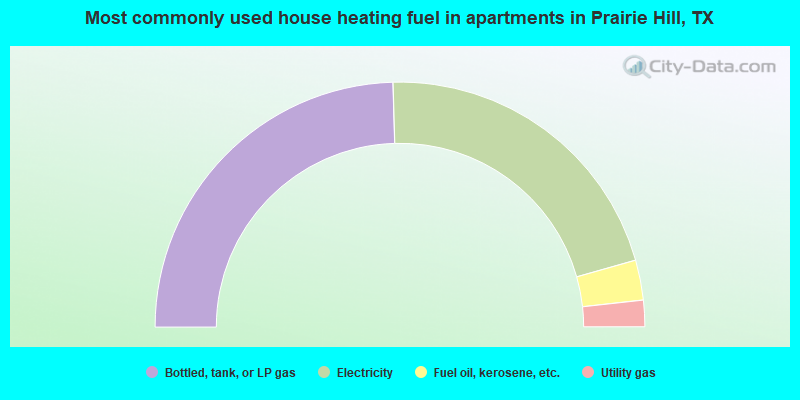
- 49.1%Bottled, tank, or LP gas
- 42.1%Electricity
- 5.3%Fuel oil, kerosene, etc.
- 3.5%Utility gas
Prairie Hill compared to Texas state average:
- Unemployed percentage significantly below state average.
- Black race population percentage significantly below state average.
- Hispanic race population percentage significantly below state average.
- Median age significantly above state average.
- Foreign-born population percentage significantly below state average.
- Renting percentage below state average.
- Length of stay since moving in significantly above state average.
- Number of rooms per house significantly below state average.
- House age significantly below state average.
- Percentage of population with a bachelor's degree or higher below state average.