Reid, Wisconsin
Submit your own pictures of this town and show them to the world
- OSM Map
- Google Map
- MSN Map
Population change since 2000: +2.0%
 |
| Males: 624 | |
| Females: 591 |
| Median resident age: | 44.4 years |
| Wisconsin median age: | 42.6 years |
Zip codes: 54440.
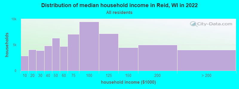
| Reid: | $78,707 |
| WI: | $70,996 |
Estimated per capita income in 2022: $39,117 (it was $20,859 in 2000)
Reid town income, earnings, and wages data
Estimated median house or condo value in 2022: $209,775 (it was $100,400 in 2000)
| Reid: | $209,775 |
| WI: | $252,800 |
Mean prices in 2022: all housing units: $244,309; detached houses: $248,058; townhouses or other attached units: $250,016; in 2-unit structures: $447,594; in 3-to-4-unit structures: $109,765; in 5-or-more-unit structures: $137,100; mobile homes: $64,848; occupied boats, rvs, vans, etc.: $112,419
Detailed information about poverty and poor residents in Reid, WI
Compare current foreclosures near Reid, WI:
| Photo | Address | Area | Beds / Baths | Price | Details |
|---|---|---|---|---|---|

|
#1
N Shore Dr
Hatley, WI 54440
|
- sq. feet
|
- baths - beds |
show details | |

|
#2
Maple Ridge Rd # 5
Mosinee, WI 54455
|
- sq. feet
|
- baths - beds |
show details | |

|
#3
Crestwood Dr Apt 3
Schofield, WI 54476
|
- sq. feet
|
- baths - beds |
show details | |

|
#4
Crossbill Ave
Wausau, WI 54401
|
- sq. feet
|
- baths - beds |
show details | |

|
#5
Townline Rd
Wausau, WI 54403
|
- sq. feet
|
- baths - beds |
show details | |

|
#6
N 1st St # 4
Wausau, WI 54403
|
- sq. feet
|
- baths - beds |
show details | |

|
#7
Metro Dr Apt 5
Schofield, WI 54476
|
- sq. feet
|
- baths - beds |
show details | |

|
#8
Bopf St
Wausau, WI 54401
|
- sq. feet
|
- baths - beds |
show details | |

|
#9
S 12th Ave
Wausau, WI 54401
|
- sq. feet
|
- baths - beds |
show details | |

|
#10
Fulton St, Apt 107
Wausau, WI 54403
|
- sq. feet
|
- baths - beds |
show details |
| Photo | Address | Area | Beds / Baths | Price | Details |
|---|---|---|---|---|---|

|
#11
Crestwood Dr Apt 4
Schofield, WI 54476
|
- sq. feet
|
- baths - beds |
show details | |

|
#12
Townline Rd Apt C
Wausau, WI 54403
|
- sq. feet
|
- baths - beds |
show details | |

|
#13
Flax Ln
Wausau, WI 54401
|
- sq. feet
|
- baths - beds |
show details | |

|
#14
S 14th Ave
Wausau, WI 54401
|
- sq. feet
|
- baths - beds |
show details | |

|
#15
Pinery Rd
Hatley, WI 54440
|
- sq. feet
|
- baths - beds |
show details | |

|
#16
Manson St Apt 5
Wausau, WI 54403
|
- sq. feet
|
- baths - beds |
show details | |

|
#17
Prospect Ave
Wausau, WI 54403
|
- sq. feet
|
- baths - beds |
show details | |

|
#18
8th St
Mosinee, WI 54455
|
- sq. feet
|
- baths - beds |
show details | |

|
#19
Rangeline Rd Apt 13
Mosinee, WI 54455
|
- sq. feet
|
- baths - beds |
show details | |

|
#20
Jelinek Ave Apt C
Schofield, WI 54476
|
- sq. feet
|
- baths - beds |
show details |
| Photo | Address | Area | Beds / Baths | Price | Details |
|---|---|---|---|---|---|

|
#21
Aspen St Apt D
Schofield, WI 54476
|
- sq. feet
|
- baths - beds |
show details | |

|
#22
Weston Pines Ln Apt 201
Schofield, WI 54476
|
- sq. feet
|
- baths - beds |
show details | |

|
#23
Brushwood Dr
Ringle, WI 54471
|
- sq. feet
|
- baths - beds |
show details | |

|
#24
State Highway 49
Eland, WI 54427
|
- sq. feet
|
- baths - beds |
show details | |

|
#25
N 6th St
Wausau, WI 54403
|
- sq. feet
|
- baths - beds |
show details | |

|
#26
Mortenson Dr
Wausau, WI 54401
|
- sq. feet
|
- baths - beds |
show details | |

|
#27
Stewart Ave Ste 140
Wausau, WI 54401
|
- sq. feet
|
- baths - beds |
show details | |

|
#28
Pine Crest Ave
Mosinee, WI 54455
|
- sq. feet
|
- baths - beds |
show details | |

|
#29
E Jelinek Ave Apt 1
Schofield, WI 54476
|
- sq. feet
|
- baths - beds |
show details | |

|
#30
Mount View Ave Apt 68
Schofield, WI 54476
|
- sq. feet
|
- baths - beds |
show details |
| Photo | Address | Area | Beds / Baths | Price | Details |
|---|---|---|---|---|---|

|
#31
Gordon St
Schofield, WI 54476
|
- sq. feet
|
- baths - beds |
show details | |

|
#32
Western Ave
Mosinee, WI 54455
|
- sq. feet
|
- baths - beds |
show details | |

|
#33
Sherman St
Wausau, WI 54401
|
- sq. feet
|
- baths - beds |
show details | |

|
#34
Landfried Ave
Mosinee, WI 54455
|
- sq. feet
|
- baths - beds |
show details | |

|
#35
S 22nd Pl
Wausau, WI 54401
|
- sq. feet
|
- baths - beds |
show details | |

|
#36
S 11th Ave
Wausau, WI 54401
|
- sq. feet
|
- baths - beds |
show details | |

|
#37
N 2nd Ave
Wausau, WI 54401
|
- sq. feet
|
- baths - beds |
show details | |

|
#38
1/2 Gowen St
Wausau, WI 54403
|
- sq. feet
|
- baths - beds |
show details | |

|
#39
N 6th St
Wausau, WI 54403
|
- sq. feet
|
- baths - beds |
show details | |

|
#40
N 12th St
Wausau, WI 54403
|
- sq. feet
|
- baths - beds |
show details |
| Photo | Address | Area | Beds / Baths | Price | Details |
|---|---|---|---|---|---|

|
#41
Callon St
Wausau, WI 54401
|
- sq. feet
|
- baths - beds |
show details | |

|
#42
W Wausau Ave
Wausau, WI 54401
|
- sq. feet
|
- baths - beds |
show details | |

|
#43
S 14th Ave
Wausau, WI 54401
|
- sq. feet
|
- baths - beds |
show details | |

|
#44
N 10th Ave
Wausau, WI 54401
|
- sq. feet
|
- baths - beds |
show details | |

|
#45
N 3rd Ave
Wausau, WI 54401
|
- sq. feet
|
- baths - beds |
show details | |

|
#46
Lincoln Ave
Wausau, WI 54403
|
- sq. feet
|
- baths - beds |
show details | |

|
#47
Spruce St
Wausau, WI 54401
|
- sq. feet
|
- baths - beds |
show details | |

|
#48
S 5th Ave
Wausau, WI 54401
|
- sq. feet
|
- baths - beds |
show details | |

|
#49
N 6th Ave
Wausau, WI 54401
|
- sq. feet
|
- baths - beds |
show details | |

|
Check over 1 million property listings on Foreclosure.com!
|
browse all offers | |||

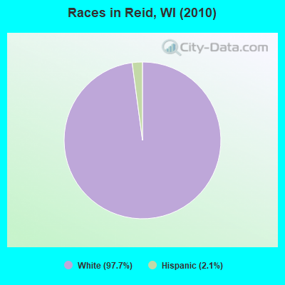
- 1,18797.7%White alone
- 262.1%Hispanic
- 10.08%American Indian alone
- 10.08%Asian alone
Races in Reid detailed stats: ancestries, foreign born residents, place of birth
 Recent articles from our blog. Our writers, many of them Ph.D. graduates or candidates, create easy-to-read articles on a wide variety of topics.

Ancestries: Polish (45.2%), German (43.2%), Dutch (3.9%), French (3.4%), Norwegian (3.1%), English (2.7%).
Current Local Time: CST time zone
Land area: 41.6 square miles.
Population density: 29 people per square mile (very low).
10 residents are foreign born
| This town: | 0.8% |
| Wisconsin: | 3.6% |
| Reid town: | 1.5% ($1,494) |
| Wisconsin: | 2.0% ($2,245) |
Nearest city with pop. 50,000+: Appleton, WI  (62.0 miles , pop. 70,087).
Nearest city with pop. 200,000+: Madison, WI (120.0 miles , pop. 208,054).
Nearest city with pop. 1,000,000+: Chicago, IL (222.9 miles , pop. 2,896,016).
Nearest cities:
), ), ), ), ), ), )Latitude: 44.81 N, Longitude: 89.40 W
Area code commonly used in this area: 715
| Here: | 2.4% |
| Wisconsin: | 2.7% |
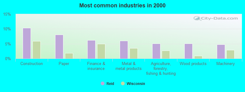
- Construction (10.3%)
- Paper (8.1%)
- Finance & insurance (6.2%)
- Metal & metal products (6.0%)
- Agriculture, forestry, fishing & hunting (5.1%)
- Wood products (5.1%)
- Machinery (4.8%)
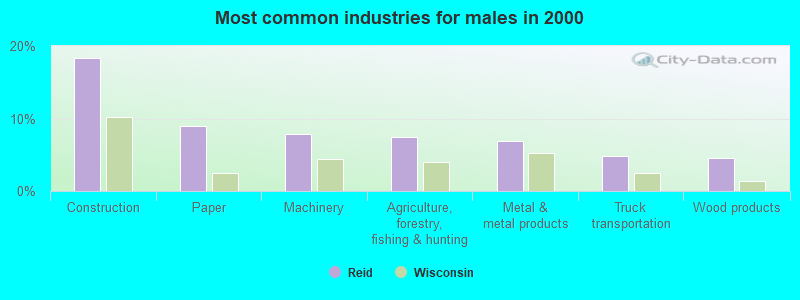
- Construction (18.3%)
- Paper (9.0%)
- Machinery (7.8%)
- Agriculture, forestry, fishing & hunting (7.5%)
- Metal & metal products (6.9%)
- Truck transportation (4.8%)
- Wood products (4.5%)
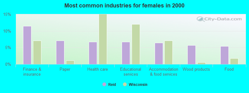
- Finance & insurance (11.4%)
- Paper (7.1%)
- Health care (6.7%)
- Educational services (6.7%)
- Accommodation & food services (6.4%)
- Wood products (5.7%)
- Food (5.4%)
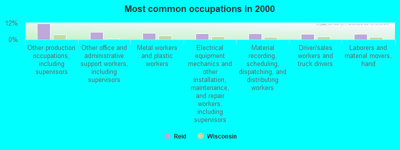
- Other production occupations, including supervisors (11.7%)
- Other office and administrative support workers, including supervisors (5.6%)
- Metal workers and plastic workers (4.8%)
- Electrical equipment mechanics and other installation, maintenance, and repair workers, including supervisors (4.4%)
- Material recording, scheduling, dispatching, and distributing workers (4.3%)
- Driver/sales workers and truck drivers (4.1%)
- Laborers and material movers, hand (4.1%)
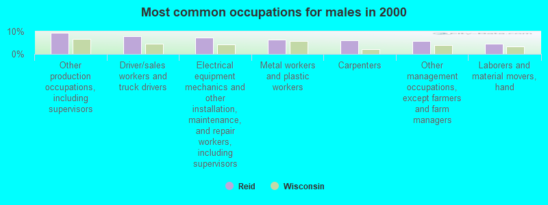
- Other production occupations, including supervisors (9.3%)
- Driver/sales workers and truck drivers (7.8%)
- Electrical equipment mechanics and other installation, maintenance, and repair workers, including supervisors (7.2%)
- Metal workers and plastic workers (6.3%)
- Carpenters (6.0%)
- Other management occupations, except farmers and farm managers (5.7%)
- Laborers and material movers, hand (4.5%)

- Other production occupations, including supervisors (14.5%)
- Other office and administrative support workers, including supervisors (10.4%)
- Secretaries and administrative assistants (5.1%)
- Material recording, scheduling, dispatching, and distributing workers (4.7%)
- Preschool, kindergarten, elementary, and middle school teachers (3.7%)
- Laborers and material movers, hand (3.7%)
- Customer service representatives (3.7%)
Average climate in Reid, Wisconsin
Based on data reported by over 4,000 weather stations


(lower is better)
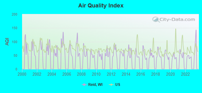
Air Quality Index (AQI) level in 2022 was 44.1. This is significantly better than average.
| City: | 44.1 |
| U.S.: | 72.6 |
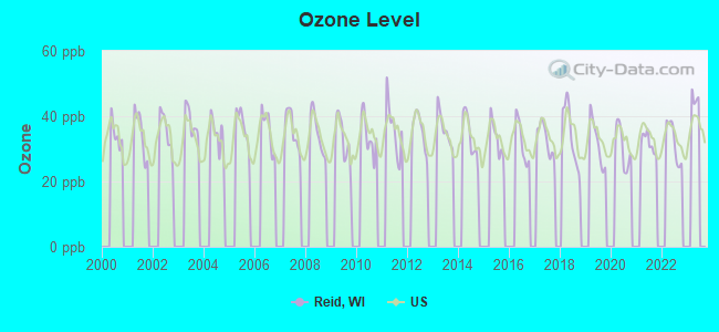
Ozone [ppb] level in 2022 was 32.1. This is about average. Closest monitor was 8.6 miles away from the city center.
| City: | 32.1 |
| U.S.: | 33.3 |
Tornado activity:
Reid-area historical tornado activity is near Wisconsin state average. It is 5% greater than the overall U.S. average.
On 6/4/1958, a category F4 (max. wind speeds 207-260 mph) tornado 33.3 miles away from the Reid town center killed 4 people and injured 3 people and caused between $500,000 and $5,000,000 in damages.
On 9/26/1951, a category F4 tornado 33.5 miles away from the town center killed 6 people and injured 3 people and caused between $50,000 and $500,000 in damages.
Earthquake activity:
Reid-area historical earthquake activity is significantly above Wisconsin state average. It is 79% smaller than the overall U.S. average.On 6/28/2004 at 06:10:52, a magnitude 4.2 (4.2 MW, Depth: 6.2 mi, Class: Light, Intensity: IV - V) earthquake occurred 233.0 miles away from the city center
On 7/9/1975 at 14:54:15, a magnitude 4.6 (4.6 MB) earthquake occurred 328.7 miles away from Reid center
On 5/2/2015 at 16:23:07, a magnitude 4.2 (4.2 MW, Depth: 2.8 mi) earthquake occurred 267.2 miles away from the city center
On 2/10/2010 at 09:59:35, a magnitude 3.8 (3.8 MW, Depth: 6.2 mi, Class: Light, Intensity: II - III) earthquake occurred 201.6 miles away from Reid center
On 9/2/1999 at 16:17:29, a magnitude 3.5 (3.5 LG, Depth: 3.1 mi) earthquake occurred 213.6 miles away from the city center
On 7/12/1986 at 08:19:37, a magnitude 4.5 (4.5 MB) earthquake occurred 390.7 miles away from Reid center
Magnitude types: regional Lg-wave magnitude (LG), body-wave magnitude (MB), moment magnitude (MW)
Natural disasters:
The number of natural disasters in Marathon County (10) is smaller than the US average (15).Major Disasters (Presidential) Declared: 8
Emergencies Declared: 2
Causes of natural disasters: Floods: 7, Storms: 7, Tornadoes: 3, Drought: 1, Hurricane: 1, Other: 1 (Note: some incidents may be assigned to more than one category).
Hospitals and medical centers near Reid:
- KINDRED TRANSITIONAL CARE AND REHAB-KENNEDY PARK (Nursing Home, about 12 miles away; SCHOFIELD, WI)
- HOMME HOME FOR THE AGING (Nursing Home, about 12 miles away; WITTENBERG, WI)
- INTERIM HLTHCARE WAUSAU (Home Health Center, about 14 miles away; WAUSAU, WI)
- NORTH CENTRAL HLTH CARE (Nursing Home, about 15 miles away; WAUSAU, WI)
- KINDRED TRANSITIONAL CARE AND REHAB-COLONIAL (Nursing Home, about 16 miles away; WAUSAU, WI)
Colleges/universities with over 2000 students nearest to Reid:
- Northcentral Technical College (about 18 miles; Wausau, WI; Full-time enrollment: 3,356)
- University of Wisconsin-Stevens Point (about 22 miles; Stevens Point, WI; FT enrollment: 9,089)
- Mid-State Technical College (about 35 miles; Wisconsin Rapids, WI; FT enrollment: 2,128)
- Fox Valley Technical College (about 60 miles; Appleton, WI; FT enrollment: 5,682)
- Lawrence University (about 63 miles; Appleton, WI; FT enrollment: 2,821)
- Northeast Wisconsin Technical College (about 67 miles; Green Bay, WI; FT enrollment: 6,069)
- University of Wisconsin-Oshkosh (about 69 miles; Oshkosh, WI; FT enrollment: 10,637)
Points of interest:
Notable locations in Reid: Dallman Dairy Farm (A), Osowski Farm (B), Ripple Ridge Farms (C), Schmidt Farm (D), Majestic Farms Greenhouse (E). Display/hide their locations on the map
Cemeteries: Peacefull Rest Cemetery (1), Our Saviors Cemetery (2). Display/hide their locations on the map
Lakes: Pike Lake (A), Bear Lake (B), Mission Lake (C). Display/hide their locations on the map
Creeks: Rice Lake Creek (A), Pike Lake Creek (B). Display/hide their locations on the map
Park in Reid: Mission Lake County Park (1). Display/hide its location on the map
| This town: | 2.5 people |
| Wisconsin: | 2.4 people |
| This town: | 77.3% |
| Whole state: | 64.4% |
| This town: | 7.2% |
| Whole state: | 7.3% |
Likely homosexual households (counted as self-reported same-sex unmarried-partner households)
- Lesbian couples: 0.2% of all households
- Gay men: 0.0% of all households
| This town: | 2.7% |
| Whole state: | 8.7% |
| This town: | 1.1% |
| Whole state: | 3.7% |
For population 15 years and over in Reid:
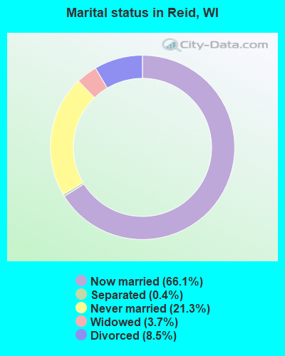
- Never married: 21.3%
- Now married: 66.1%
- Separated: 0.4%
- Widowed: 3.7%
- Divorced: 8.5%
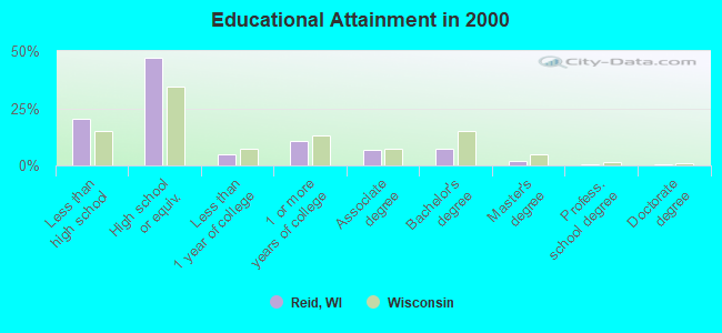
For population 25 years and over in Reid:
- High school or higher: 79.8%
- Bachelor's degree or higher: 10.2%
- Graduate or professional degree: 2.8%
- Unemployed: 6.3%
- Mean travel time to work (commute): 26.1 minutes
| Here: | 10.2 |
| Wisconsin average: | 11.0 |
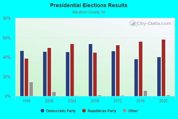
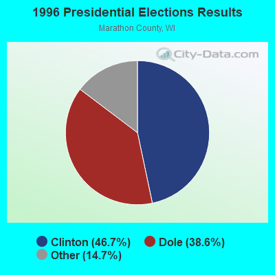
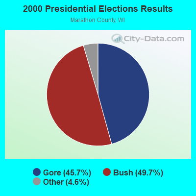
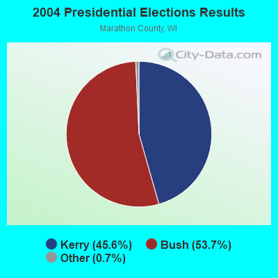
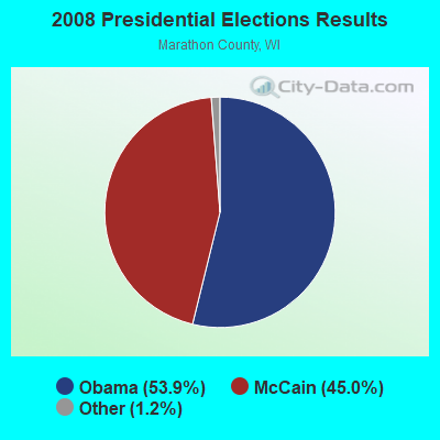
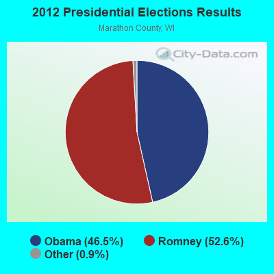
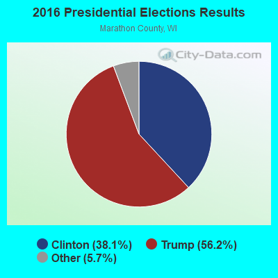
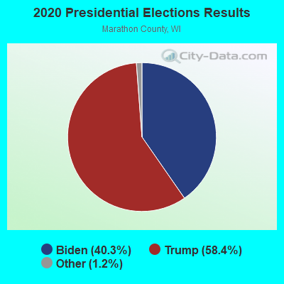
Graphs represent county-level data. Detailed 2008 Election Results
Religion statistics for Reid, WI (based on Marathon County data)
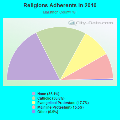
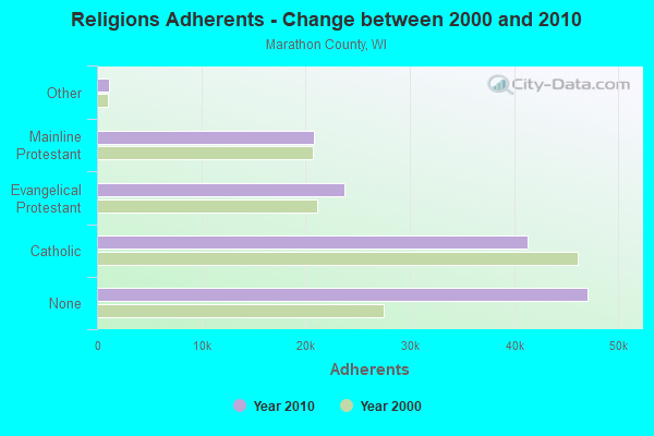
| Religion | Adherents | Congregations |
|---|---|---|
| Catholic | 41,260 | 25 |
| Evangelical Protestant | 23,686 | 75 |
| Mainline Protestant | 20,779 | 39 |
| Other | 1,196 | 9 |
| Orthodox | 40 | 1 |
| None | 47,102 | - |
Food Environment Statistics:
| Marathon County: | 2.47 / 10,000 pop. |
| Wisconsin: | 1.86 / 10,000 pop. |
| Marathon County: | 0.23 / 10,000 pop. |
| Wisconsin: | 0.11 / 10,000 pop. |
| Marathon County: | 4.16 / 10,000 pop. |
| Wisconsin: | 4.12 / 10,000 pop. |
| Marathon County: | 8.17 / 10,000 pop. |
| Wisconsin: | 8.64 / 10,000 pop. |
| Here: | 7.9% |
| Wisconsin: | 7.6% |
| Here: | 27.1% |
| Wisconsin: | 27.5% |
| Here: | 13.2% |
| Wisconsin: | 13.0% |
Strongest AM radio stations in Reid:
- WSAU (550 AM; 20 kW; WAUSAU, WI; Owner: WRIG, INC.)
- WSPT (1010 AM; 50 kW; STEVENS POINT, WI)
- WRIG (1390 AM; 10 kW; SCHOFIELD, WI; Owner: WRIG, INC.)
- WNAM (1280 AM; 50 kW; NEENAH-MENASHA, WI; Owner: CUMULUS LICENSING CORP.)
- WHBY (1150 AM; 25 kW; KIMBERLY, WI; Owner: WOODWARD COMMUNICATIONS, INC.)
- WDUX (800 AM; 5 kW; WAUPACA, WI; Owner: LAIRD BROADCASTING COMPANY, INC.)
- WLBL (930 AM; 5 kW; AUBURNDALE, WI; Owner: STATE OF WISCONSIN - EDUCATIONAL COMMUNICATIONS BOARD)
- WXCO (1230 AM; 1 kW; WAUSAU, WI; Owner: SEEHAFER BROADCASTING CORPORATION)
- WFHR (1320 AM; 5 kW; WISCONSIN RAPIDS, WI; Owner: WISCONSIN RAPIDS BROADCASTING, LLC)
- WTMJ (620 AM; 50 kW; MILWAUKEE, WI; Owner: JOURNAL BROADCAST CORPORATION)
- WEBC (560 AM; 50 kW; DULUTH, MN)
- WFCL (1380 AM; 4 kW; CLINTONVILLE, WI; Owner: RESULTS BROADCASTING CORP.)
- WISN (1130 AM; 50 kW; MILWAUKEE, WI; Owner: CAPSTAR TX LIMITED PARTNERSHIP)
Strongest FM radio stations in Reid:
- WHRM (90.9 FM; WAUSAU, WI; Owner: STATE OF WISCONSIN - EDUCATIONAL COMMUNICATIONS BOARD)
- WIFC (95.5 FM; WAUSAU, WI; Owner: WRIG, INC.)
- WDEZ (101.9 FM; WAUSAU, WI; Owner: W R I G, INC.)
- WYCO (107.9 FM; WAUSAU, WI; Owner: SEEHAFER BROADCASTING CORPORATION)
- WLBL-FM (91.9 FM; WAUSAU, WI; Owner: STATE OF WISCONSIN - EDUCATIONAL COMMUNICATIONS BOARD)
- WXPW (91.9 FM; WAUSAU, WI; Owner: WHITE PINE COMMUNITY BROADCASTING, INC)
- WCLQ (89.5 FM; WAUSAU, WI; Owner: CHRISTIAN LIFE COMMUNICATIONS, INC.)
- WLJY (106.5 FM; MARSHFIELD, WI; Owner: NEWRADIO GROUP, LLC)
- WYNW (92.9 FM; BIRNAMWOOD, WI; Owner: STARBOARD BROADCASTING, INC.)
- WMZK (104.1 FM; MERRILL, WI; Owner: ROBERTS BROADCASTING, INC.)
- WGNV (88.5 FM; MILLADORE, WI; Owner: EVANGEL MINISTRIES, INC.)
- WYTE (96.7 FM; WHITING, WI; Owner: NEWRADIO GROUP, LLC)
- WGLX-FM (103.3 FM; WISCONSIN RAPIDS, WI; Owner: WISCONSIN RAPIDS BROADCASTING, LLC)
- WKQH (104.9 FM; MARATHON, WI; Owner: RLM COMMUNICATIONS, INC)
- WRLO-FM (105.3 FM; ANTIGO, WI; Owner: NEWRADIO GROUP, LLC)
- WSPT-FM (97.9 FM; STEVENS POINT, WI; Owner: AMERICUS COMMUNICATIONS, LLC)
- WWSP (89.9 FM; STEVENS POINT, WI; Owner: BD. OF REGENTS OF UNIV. OF WISCONSIN)
TV broadcast stations around Reid:
- WFXS (Channel 55; WITTENBERG, WI; Owner: DAVIS TELEVISION WAUSAU, LLC)
- WAOW-TV (Channel 9; WAUSAU, WI; Owner: WAOW-WYOW TELEVISION, INC.)
- WSAW-TV (Channel 7; WAUSAU, WI; Owner: GRAY MIDAMERICA TV LICENSEE CORP.)
- W24BV (Channel 24; WHITING, WI; Owner: MS COMMUNICATIONS, LLC)
- WHRM-TV (Channel 20; WAUSAU, WI; Owner: STATE OF WISCONSIN - EDUCATIONAL COMMUNICATIONS BOARD)
- W60CI (Channel 60; WHITING, WI; Owner: MS COMMUNICATIONS, LLC)
- W16AY (Channel 16; WHITING, WI; Owner: MS COMMUNICATIONS, LLC)
- W18CS (Channel 18; WHITING, WI; Owner: MS COMMUNICATIONS, LLC)
- W40BC (Channel 40; WHITING, WI; Owner: MS COMMUNICATIONS, LLC)
- W62DA (Channel 62; WHITING, WI; Owner: MS COMMUNICATIONS, LLC)
- WYOW (Channel 34; EAGLE RIVER, WI; Owner: WAOW-WYOW TELEVISION, INC.)
- W31CI (Channel 31; WHITING, WI; Owner: MS COMMUNICATIONS, LLC)
- W27AU (Channel 27; WAUSAU, WI; Owner: NORTHLAND TELEVISION, INC.)
- WTPX (Channel 46; ANTIGO, WI; Owner: PAXSON WAUSAU LICENSE, INC.)
- W06BU (Channel 6; WHITING, WI; Owner: MS COMMUNICATIONS, LLC)
- National Bridge Inventory (NBI) Statistics
- 9Number of bridges
- 66ft / 20.1mTotal length
- 3,955Total average daily traffic
- 201Total average daily truck traffic
- 4,625Total future (year 2035) average daily traffic
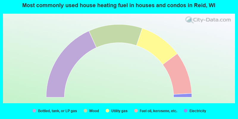
- 36.4%Bottled, tank, or LP gas
- 23.9%Wood
- 19.2%Utility gas
- 18.7%Fuel oil, kerosene, etc.
- 1.7%Electricity
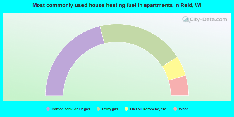
- 42.4%Bottled, tank, or LP gas
- 39.4%Utility gas
- 9.1%Fuel oil, kerosene, etc.
- 9.1%Wood
Reid compared to Wisconsin state average:
- Unemployed percentage below state average.
- Black race population percentage significantly below state average.
- Hispanic race population percentage significantly below state average.
- Foreign-born population percentage significantly below state average.
- Renting percentage significantly below state average.
- Length of stay since moving in significantly above state average.
- Number of rooms per house significantly below state average.
- House age significantly below state average.
- Number of college students below state average.
- Percentage of population with a bachelor's degree or higher significantly below state average.