Sand Gap, Kentucky
Submit your own pictures of this place and show them to the world
- OSM Map
- General Map
- Google Map
- MSN Map

| Males: 1,382 | |
| Females: 1,449 |
| Median resident age: | 36.1 years |
| Kentucky median age: | 35.9 years |
Zip code: 40447
| Sand Gap: | $34,860 |
| KY: | $59,341 |
Estimated per capita income in 2022: $20,326 (it was $9,816 in 2000)
Sand Gap CCD income, earnings, and wages data
Estimated median house or condo value in 2022: $105,820 (it was $41,200 in 2000)
| Sand Gap: | $105,820 |
| KY: | $196,300 |
Detailed information about poverty and poor residents in Sand Gap, KY


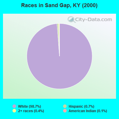
- 2,81398.7%White alone
- 190.7%Hispanic
- 120.4%Two or more races
- 30.1%American Indian alone
- 20.07%Asian alone
- 20.07%Other race alone
Races in Sand Gap detailed stats: ancestries, foreign born residents, place of birth
 Recent articles from our blog. Our writers, many of them Ph.D. graduates or candidates, create easy-to-read articles on a wide variety of topics.

Current Local Time: EST time zone
Land area: 97.9 square miles.
Population density: 29 people per square mile (very low).

| Sand Gap CCD: | 0.6% ($257) |
| Kentucky: | 0.8% ($610) |
Nearest city with pop. 50,000+: Fayette, KY  (43.0 miles , pop. 260,512).
Nearest city with pop. 1,000,000+: Chicago, IL (356.0 miles , pop. 2,896,016).
Nearest cities:
), ), ), )Latitude: 37.48 N, Longitude: 84.13 W
Area code commonly used in this area: 606

| Here: | 5.4% |
| Kentucky: | 3.8% |
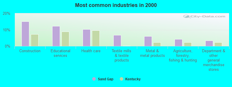
- Construction (15.0%)
- Educational services (12.2%)
- Health care (10.2%)
- Textile mills & textile products (6.6%)
- Metal & metal products (6.0%)
- Agriculture, forestry, fishing & hunting (4.2%)
- Department & other general merchandise stores (3.4%)
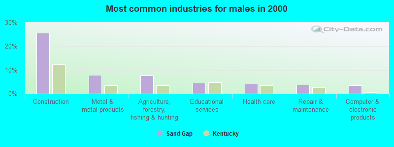
- Construction (25.6%)
- Metal & metal products (7.8%)
- Agriculture, forestry, fishing & hunting (7.6%)
- Educational services (4.5%)
- Health care (4.1%)
- Repair & maintenance (3.7%)
- Computer & electronic products (3.5%)
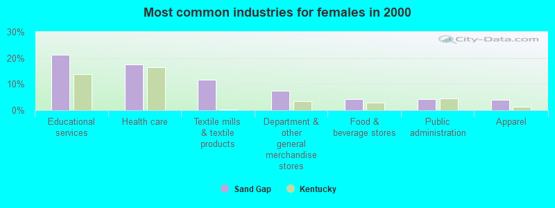
- Educational services (21.3%)
- Health care (17.6%)
- Textile mills & textile products (11.7%)
- Department & other general merchandise stores (7.4%)
- Food & beverage stores (4.2%)
- Public administration (4.2%)
- Apparel (4.0%)
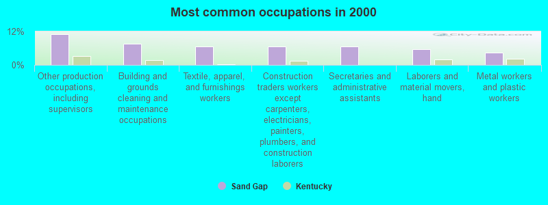
- Other production occupations, including supervisors (11.0%)
- Building and grounds cleaning and maintenance occupations (7.5%)
- Textile, apparel, and furnishings workers (6.6%)
- Construction traders workers except carpenters, electricians, painters, plumbers, and construction laborers (6.6%)
- Secretaries and administrative assistants (6.5%)
- Laborers and material movers, hand (5.5%)
- Metal workers and plastic workers (4.5%)
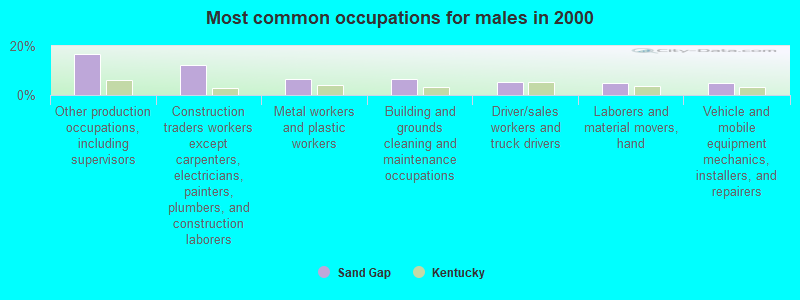
- Other production occupations, including supervisors (16.9%)
- Construction traders workers except carpenters, electricians, painters, plumbers, and construction laborers (12.2%)
- Metal workers and plastic workers (6.6%)
- Building and grounds cleaning and maintenance occupations (6.6%)
- Driver/sales workers and truck drivers (5.2%)
- Laborers and material movers, hand (4.9%)
- Vehicle and mobile equipment mechanics, installers, and repairers (4.7%)
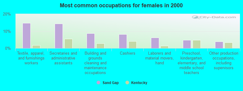
- Textile, apparel, and furnishings workers (14.6%)
- Secretaries and administrative assistants (14.4%)
- Building and grounds cleaning and maintenance occupations (8.7%)
- Cashiers (8.2%)
- Laborers and material movers, hand (6.2%)
- Preschool, kindergarten, elementary, and middle school teachers (4.7%)
- Other production occupations, including supervisors (4.0%)
Average climate in Sand Gap, Kentucky
Based on data reported by over 4,000 weather stations


Tornado activity:
Sand Gap-area historical tornado activity is slightly below Kentucky state average. It is 8% smaller than the overall U.S. average.
On 4/3/1974, a category F4 (max. wind speeds 207-260 mph) tornado 26.4 miles away from the Sand Gap place center killed 7 people and injured 28 people.
On 4/3/1974, a category F3 (max. wind speeds 158-206 mph) tornado 12.7 miles away from the place center killed 7 people and injured 40 people and caused between $500,000 and $5,000,000 in damages.
Earthquake activity:
Sand Gap-area historical earthquake activity is significantly above Kentucky state average. It is 69% greater than the overall U.S. average.On 7/27/1980 at 18:52:21, a magnitude 5.2 (5.1 MB, 4.7 MS, 5.0 UK, 5.2 UK, Class: Moderate, Intensity: VI - VII) earthquake occurred 51.1 miles away from Sand Gap center
On 9/7/1988 at 02:28:09, a magnitude 4.6 (4.5 MB, 4.6 LG, Class: Light, Intensity: IV - V) earthquake occurred 47.8 miles away from the city center
On 4/18/2008 at 09:36:59, a magnitude 5.4 (5.1 MB, 4.8 MS, 5.4 MW, 5.2 MW) earthquake occurred 215.8 miles away from the city center
On 8/9/2020 at 12:07:37, a magnitude 5.1 (5.1 MW, Depth: 4.7 mi) earthquake occurred 181.3 miles away from Sand Gap center
On 4/18/2008 at 09:36:59, a magnitude 5.2 (5.2 MW, Depth: 8.9 mi) earthquake occurred 215.8 miles away from Sand Gap center
On 11/30/1973 at 07:48:41, a magnitude 4.7 (4.7 MB, 4.6 ML) earthquake occurred 116.6 miles away from Sand Gap center
Magnitude types: regional Lg-wave magnitude (LG), body-wave magnitude (MB), local magnitude (ML), surface-wave magnitude (MS), moment magnitude (MW)
Natural disasters:
The number of natural disasters in Jackson County (23) is greater than the US average (15).Major Disasters (Presidential) Declared: 16
Emergencies Declared: 3
Causes of natural disasters: Floods: 13, Storms: 12, Mudslides: 8, Tornadoes: 6, Winter Storms: 6, Landslides: 4, Fires: 2, Snowstorms: 2, Winds: 2, Blizzard: 1, Freeze: 1, Hurricane: 1, Snow: 1, Snowfall: 1, Other: 1 (Note: some incidents may be assigned to more than one category).
Hospitals and medical centers near Sand Gap:
- BEREA HOSPITAL CHI (Hospital, about 12 miles away; BEREA, KY)
- SAINT JOSEPH BEREA Critical Access Hospitals (about 12 miles away; BEREA, KY)
- BEREA HEALTH CARE CENTER (Nursing Home, about 12 miles away; BEREA, KY)
- THE TERRACE NURSING AND REHABILITATION CENTER (Nursing Home, about 13 miles away; BEREA, KY)
- LIFELINE ROCKCASTLE HOME HEALTH (Home Health Center, about 15 miles away; MOUNT VERNON, KY)
Colleges/universities with over 2000 students nearest to Sand Gap:
- Eastern Kentucky University (about 21 miles; Richmond, KY; Full-time enrollment: 13,525)
- Somerset Community College (about 40 miles; Somerset, KY; FT enrollment: 4,698)
- Bluegrass Community and Technical College (about 43 miles; Lexington, KY; FT enrollment: 8,560)
- University of Kentucky (about 44 miles; Lexington, KY; FT enrollment: 23,517)
- University of the Cumberlands (about 52 miles; Williamsburg, KY; FT enrollment: 3,585)
- Hazard Community and Technical College (about 55 miles; Hazard, KY; FT enrollment: 2,087)
- Morehead State University (about 62 miles; Morehead, KY; FT enrollment: 7,523)
Public elementary/middle school in Sand Gap:
- SAND GAP ELEMENTARY SCHOOL (Students: 269, Location: 6783 HWY 421 N, Grades: PK-5)
Points of interest:
Notable locations in Sand Gap: Rose's Mill (A), Powells Mill (B), Gravel Lick (C), Sand Gap Fire Department Station 2 (D), Sand Gap Fire Department (E). Display/hide their locations on the map
Churches in Sand Gap include: Clover Bottom Church (A), Cave Spring Church (B), Bethel Baptist Church (C), Hugh Church (D), South Fork Church (E), Pony Lot Church (F), Lettered Rock Church (G), Grassy Springs Church (H), Davis Church (I). Display/hide their locations on the map
Cemeteries: Isaacs Cemetery (1), Harrison Cemetery (2), Combs Cemetery (3), Wilson Cemetery (4), Skinner Cemetery (5), Cox Cemetery (6), Rose Cemetery (7). Display/hide their locations on the map
Streams, rivers, and creeks: Cane Branch (A), Clover Bottom Creek (B), Dry Branch (C), Dry Fork (D), Gravel Lick Branch (E), Little Clover Creek (F), Long Branch (G), Powell Branch (H), Raccoon Creek (I). Display/hide their locations on the map
| This place: | 2.4 people |
| Kentucky: | 2.5 people |
| This place: | 70.6% |
| Whole state: | 66.9% |
| This place: | 5.0% |
| Whole state: | 6.4% |
Likely homosexual households (counted as self-reported same-sex unmarried-partner households)
- Lesbian couples: 0.5% of all households
- Gay men: 0.3% of all households
| This place: | 32.5% |
| Whole state: | 15.8% |
| This place: | 11.2% |
| Whole state: | 6.6% |
For population 15 years and over in Sand Gap:
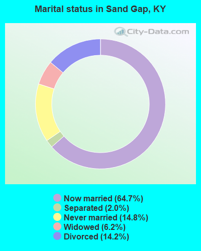
- Never married: 14.8%
- Now married: 64.7%
- Separated: 2.0%
- Widowed: 6.2%
- Divorced: 14.2%
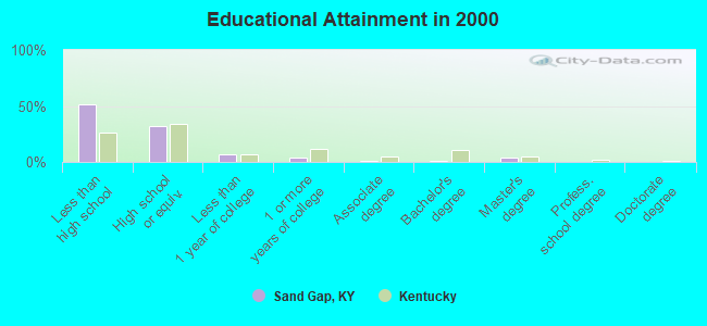
For population 25 years and over in Sand Gap:
- High school or higher: 48.7%
- Bachelor's degree or higher: 4.8%
- Graduate or professional degree: 3.6%
- Unemployed: 10.5%
- Mean travel time to work (commute): 37.5 minutes
| Here: | 20.1 |
| Kentucky average: | 13.8 |
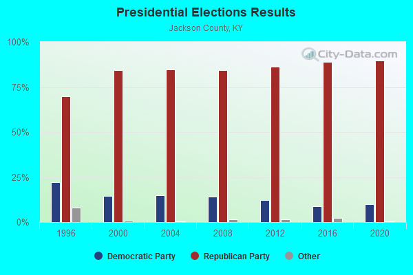
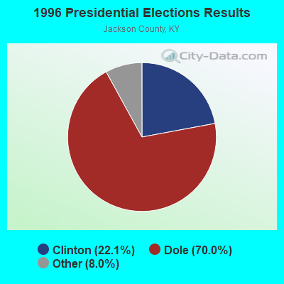

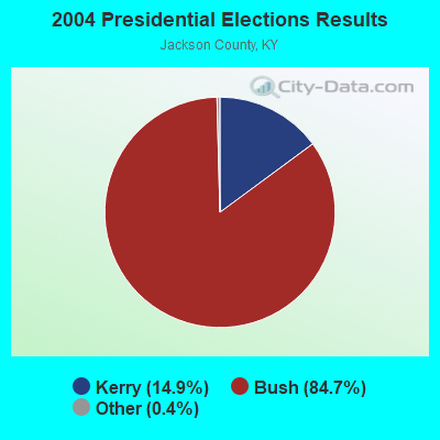

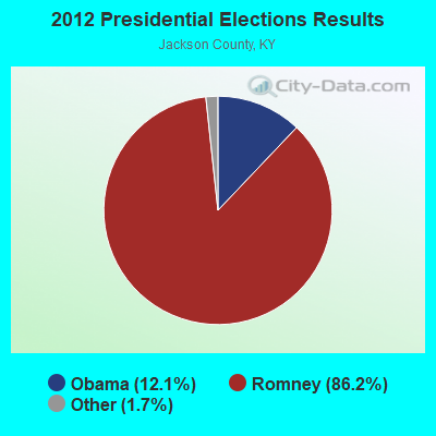
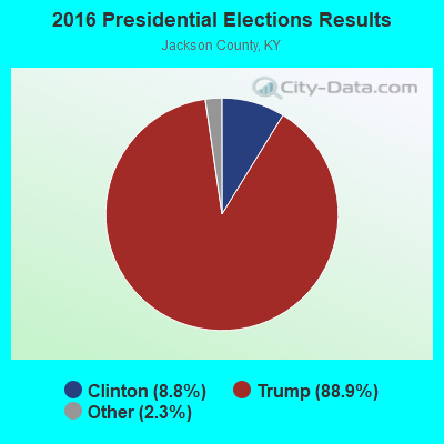
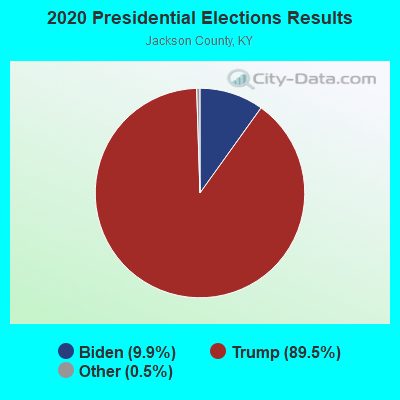
Graphs represent county-level data. Detailed 2008 Election Results
Religion statistics for Sand Gap, KY (based on Jackson County data)
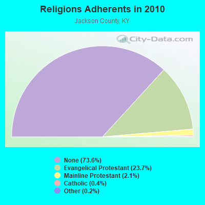
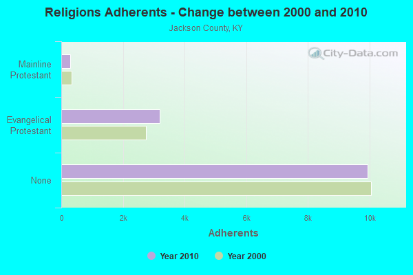
| Religion | Adherents | Congregations |
|---|---|---|
| Evangelical Protestant | 3,193 | 28 |
| Mainline Protestant | 290 | 4 |
| Catholic | 48 | 1 |
| Other | 33 | 1 |
| None | 9,930 | - |
Food Environment Statistics:
| Jackson County: | 2.21 / 10,000 pop. |
| State: | 2.19 / 10,000 pop. |
| Jackson County: | 0.74 / 10,000 pop. |
| State: | 0.74 / 10,000 pop. |
| This county: | 8.10 / 10,000 pop. |
| Kentucky: | 4.36 / 10,000 pop. |
| Jackson County: | 1.47 / 10,000 pop. |
| Kentucky: | 5.74 / 10,000 pop. |
| Jackson County: | 11.7% |
| Kentucky: | 11.0% |
| Jackson County: | 31.7% |
| State: | 30.0% |
| This county: | 19.0% |
| Kentucky: | 15.9% |
Strongest AM radio stations in Sand Gap:
- WHAS (840 AM; 50 kW; LOUISVILLE, KY; Owner: CLEAR CHANNEL BROADCASTING LICENSES, INC.)
- WKVL (850 AM; daytime; 50 kW; KNOXVILLE, TN; Owner: HORNE RADIO, LLC)
- WMTC (730 AM; 5 kW; VANCLEVE, KY; Owner: THE KENTUCKY MOUNTAIN HOLINESS ASSN.)
- WKLB (1290 AM; 5 kW; MANCHESTER, KY; Owner: BARKER BROADCASTING COMPANY, INC.)
- WLW (700 AM; 50 kW; CINCINNATI, OH; Owner: JACOR BROADCASTING CORPORATION)
- WEKG (810 AM; daytime; 5 kW; JACKSON, KY; Owner: INTERMOUNTAIN B/CING CO., INC.)
- WLAP (630 AM; 5 kW; LEXINGTON, KY; Owner: CITICASTERS LICENSES, L.P.)
- WVLK (590 AM; 5 kW; LEXINGTON, KY; Owner: CUMULUS LICENSING CORP.)
- WTVN (610 AM; 50 kW; COLUMBUS, OH; Owner: CITICASTERS LICENSES, L.P.)
- WKDP (1330 AM; 5 kW; CORBIN, KY; Owner: EUBANKS BROADCASTING, INC.)
- WSAI (1530 AM; 50 kW; CINCINNATI, OH; Owner: JACOR BROADCASTING CORPORATION)
- WEKC (710 AM; daytime; 4 kW; WILLIAMSBURG, KY; Owner: GERALD PARKS)
- WSM (650 AM; 50 kW; NASHVILLE, TN; Owner: GAYLORD ENTERTAINMENT COMPANY)
Strongest FM radio stations in Sand Gap:
- WLFX (106.7 FM; BEREA, KY; Owner: WALLINGFORD COMMUNICATIONS, LLC)
- WCYO (100.7 FM; IRVINE, KY; Owner: KENTUCKY RIVER BROADCASTING CO.)
- WWAG (107.9 FM; MCKEE, KY; Owner: DANDY BROADCASTING, INC.)
- WYGE (92.3 FM; LONDON, KY; Owner: ETHEL HUFF BROADCASTING, LLC)
- WTBK (105.7 FM; MANCHESTER, KY; Owner: MANCHESTER COMMUNICATIONS, INC.)
- WSKV-FM (104.9 FM; STANTON, KY; Owner: PARKS BROADCASTING, INC.)
- WLJC (102.1 FM; BEATTYVILLE, KY; Owner: HOUR OF HARVEST, INCORPORATED)
- WEKU (88.9 FM; RICHMOND, KY; Owner: EASTERN KENTUCKY UNIVERSITY)
- WUKY (91.3 FM; LEXINGTON, KY; Owner: BD. OF TRUSTEES UNIV. OF KENTUCKY)
- WJSN-FM (106.5 FM; JACKSON, KY; Owner: INTERMOUNTAIN BROADCASTING CO.)
- WLRO (101.5 FM; RICHMOND, KY; Owner: CUMULUS LICENSING CORP.)
- WKDP-FM (99.5 FM; CORBIN, KY; Owner: EUBANKS BROADCASTING, INC.)
- WLLK (93.9 FM; BURNSIDE, KY; Owner: CAPSTAR TX LIMITED PARTNERSHIP)
- WTHL (90.5 FM; SOMERSET, KY; Owner: SOMERSET EDUCATIONAL BROADCASTING FOUNDATION)
- WWEL (103.9 FM; LONDON, KY; Owner: F.T.G. BROADCASTING, INC.)
- WWLT (103.1 FM; MANCHESTER, KY; Owner: VERNON R. BALDWIN, INC.)
TV broadcast stations around Sand Gap:
- WBLU-LP (Channel 62; LEXINGTON, KY; Owner: SANDRA B. POWLEY)
- WLJC-TV (Channel 65; BEATTYVILLE, KY; Owner: HOUR OF HARVEST, INC.)
- WDKY-TV (Channel 56; DANVILLE, KY; Owner: WDKY LICENSEE, LLC)
- WUPX-TV (Channel 67; MOREHEAD, KY; Owner: PAXSON LEXINGTON LICENSE, INC.)
- W26BK (Channel 26; TALBERT, KY; Owner: MS COMMUNICATIONS, LLC)
- WLEX-TV (Channel 18; LEXINGTON, KY; Owner: WLEX COMMUNICATIONS, L.L.C.)
- WKLE (Channel 46; LEXINGTON, KY; Owner: KENTUCKY AUTHORITY FOR EDUCATIONAL TV)
- W16BI (Channel 16; TALBERT, KY; Owner: MS COMMUNICATIONS, LLC)
- WKYT-TV (Channel 27; LEXINGTON, KY; Owner: WKYT LICENSEE CORP.)
- WTVQ-TV (Channel 36; LEXINGTON, KY; Owner: MEDIA GENERAL COMMUNICATIONS, INC.)
- WKSO-TV (Channel 29; SOMERSET, KY; Owner: KENTUCKY AUTHORITY FOR EDUCATIONAL TV)
- WOBZ-LP (Channel 9; EAST BERNSTADT, ETC., KY; Owner: ANDREA JOY KESLER)
FCC Registered Amateur Radio Licenses:
1- Call Sign: KG4BPF, Grant Date: 01/17/1999, Expiration Date: 01/17/2009, Cancellation Date: 01/19/2011, Registrant: Ermon D Turner, Sand Gap, KY 40481
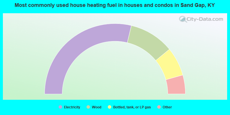
- 57.5%Electricity
- 20.6%Wood
- 13.2%Bottled, tank, or LP gas
- 3.9%Fuel oil, kerosene, etc.
- 2.8%Utility gas
- 2.0%Coal or coke
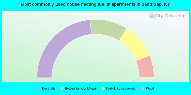
- 47.0%Electricity
- 21.0%Bottled, tank, or LP gas
- 19.5%Fuel oil, kerosene, etc.
- 12.5%Wood
Sand Gap compared to Kentucky state average:
- Median household income below state average.
- Median house value below state average.
- Black race population percentage significantly below state average.
- Hispanic race population percentage significantly below state average.
- Median age below state average.
- Foreign-born population percentage significantly below state average.
- Length of stay since moving in significantly above state average.
- Number of rooms per house significantly below state average.
- House age significantly below state average.
- Number of college students below state average.
- Percentage of population with a bachelor's degree or higher significantly below state average.