Statenville, Georgia
Submit your own pictures of this place and show them to the world
- OSM Map
- Google Map
- MSN Map
| Males: 481 | |
| Females: 559 |
| Median resident age: | 33.1 years |
| Georgia median age: | 37.6 years |
Zip codes: 31648.
| Statenville: | $62,455 |
| GA: | $72,837 |
Estimated per capita income in 2022: $25,106
Statenville CDP income, earnings, and wages data
Estimated median house or condo value in 2022: $138,964
| Statenville: | $138,964 |
| GA: | $297,400 |
Mean prices in 2022: all housing units: $92,744; detached houses: $146,958; mobile homes: $41,027
Median gross rent in 2022: $942.
(42.6% for White Non-Hispanic residents, 23.9% for Black residents, 65.3% for Hispanic or Latino residents, 30.8% for two or more races residents)
Detailed information about poverty and poor residents in Statenville, GA
Compare current foreclosures in Statenville, GA:
| Photo | Address | Area | Beds / Baths | Price | Details |
|---|---|---|---|---|---|

|
#1
Dolly Rd
Statenville, GA 31648
|
825 sq. feet
|
- baths - beds |
show details | |

|
#2
Sylvia St
Statenville, GA 31648
|
- sq. feet
|
2 baths - beds |
show details | |

|
#3
Charles Cir
Statenville, GA 31648
|
- sq. feet
|
- baths - beds |
show details | |

|
Check over 1 million property listings on Foreclosure.com!
|
browse all offers | |||

- 65352.3%White alone
- 51841.5%Hispanic
- 514.1%Black alone
- 272.2%Two or more races
- 30.2%American Indian alone

Races in Statenville detailed stats: ancestries, foreign born residents, place of birth
According to our research of Georgia and other state lists, there were 3 registered sex offenders living in Statenville, Georgia as of May 10, 2024.
The ratio of all residents to sex offenders in Statenville is 392 to 1.
The ratio of registered sex offenders to all residents in this city is near the state average.
 Recent articles from our blog. Our writers, many of them Ph.D. graduates or candidates, create easy-to-read articles on a wide variety of topics.

Ancestries: American (13.2%), Irish (8.6%), English (3.9%), Scottish (1.5%).
Current Local Time: EST time zone
Elevation: 138 feet
191 residents are foreign born (14.7% Latin America).
| This place: | 15.3% |
| Georgia: | 100.0% |
Median real estate property taxes paid for housing units with mortgages in 2022: $818 (0.8%)
Median real estate property taxes paid for housing units with no mortgage in 2022: $527 (1.0%)
Nearest city with pop. 50,000+: Tallahassee, FL  (76.1 miles , pop. 150,624).
Nearest city with pop. 200,000+: Jacksonville, FL (85.7 miles , pop. 735,617).
Nearest city with pop. 1,000,000+: Houston, TX (740.8 miles , pop. 1,953,631).
Nearest cities:
), ), ), Latitude: 30.70 N, Longitude: 83.03 W


| Here: | 2.8% |
| Georgia: | 2.9% |
(lower is better)

Air Quality Index (AQI) level in 2023 was 78.1. This is about average.
| City: | 78.1 |
| U.S.: | 72.6 |

Particulate Matter (PM2.5) [µg/m3] level in 2023 was 10.6. This is worse than average. Closest monitor was 18.7 miles away from the city center.
| City: | 10.6 |
| U.S.: | 8.1 |

Lead (Pb) [µg/m3] level in 2008 was 0.00215. This is significantly better than average. Closest monitor was 18.7 miles away from the city center.
| City: | 0.00215 |
| U.S.: | 0.00931 |
Tornado activity:
Statenville-area historical tornado activity is slightly below Georgia state average. It is 8% smaller than the overall U.S. average.
On 4/19/1988, a category F3 (max. wind speeds 158-206 mph) tornado 15.8 miles away from the Statenville place center killed 4 people and injured 18 people and caused between $5,000,000 and $50,000,000 in damages.
On 7/8/1966, a category F2 (max. wind speeds 113-157 mph) tornado 14.8 miles away from the place center injured one person and caused between $50,000 and $500,000 in damages.
Earthquake activity:
Statenville-area historical earthquake activity is above Georgia state average. It is 76% smaller than the overall U.S. average.On 9/10/2006 at 14:56:08, a magnitude 5.9 (5.9 MB, 5.5 MS, 5.8 MW, Class: Moderate, Intensity: VI - VII) earthquake occurred 377.9 miles away from Statenville center
On 8/2/1974 at 08:52:09, a magnitude 4.9 (4.3 MB, 4.9 LG, Class: Light, Intensity: IV - V) earthquake occurred 221.4 miles away from Statenville center
On 10/24/1997 at 08:35:17, a magnitude 4.9 (4.8 MB, 4.2 MS, 4.9 LG, Depth: 6.2 mi) earthquake occurred 253.5 miles away from the city center
On 11/22/1974 at 05:25:55, a magnitude 4.7 (4.7 MB) earthquake occurred 227.6 miles away from Statenville center
On 4/29/2003 at 08:59:39, a magnitude 4.9 (4.4 MB, 4.6 MW, 4.9 LG) earthquake occurred 302.8 miles away from the city center
On 8/21/1992 at 16:31:55, a magnitude 4.4 (4.1 MB, 4.1 LG, 4.4 LG, Depth: 6.2 mi) earthquake occurred 235.8 miles away from Statenville center
Magnitude types: regional Lg-wave magnitude (LG), body-wave magnitude (MB), surface-wave magnitude (MS), moment magnitude (MW)
Natural disasters:
The number of natural disasters in Echols County (9) is smaller than the US average (15).Major Disasters (Presidential) Declared: 4
Emergencies Declared: 3
Causes of natural disasters: Hurricanes: 3, Storms: 3, Tornadoes: 3, Floods: 2, Winds: 2, Drought: 1, Tropical Storm: 1, Other: 1 (Note: some incidents may be assigned to more than one category).
Hospitals and medical centers near Statenville:
- SUWANNEE VALLEY NURSING CENTER (Nursing Home, about 14 miles away; JASPER, FL)
- TRINITY COMMUNITY HOSPITAL (Hospital, about 14 miles away; JASPER, FL)
- CRESTWOOD NH (Nursing Home, about 16 miles away; VALDOSTA, GA)
- HOLLY HILL INTERMEDIATE CARE FACILITY (Nursing Home, about 16 miles away; VALDOSTA, GA)
Colleges/universities with over 2000 students nearest to Statenville:
- Valdosta State University (about 19 miles; Valdosta, GA; Full-time enrollment: 11,155)
- Wiregrass Georgia Technical College (about 24 miles; Valdosta, GA; FT enrollment: 3,246)
- Florida Gateway College (about 46 miles; Lake City, FL; FT enrollment: 2,179)
- South Georgia State College (about 56 miles; Douglas, GA; FT enrollment: 2,507)
- Abraham Baldwin Agricultural College (about 62 miles; Tifton, GA; FT enrollment: 2,564)
- Florida Agricultural and Mechanical University (about 78 miles; Tallahassee, FL; FT enrollment: 10,841)
- Florida State University (about 78 miles; Tallahassee, FL; FT enrollment: 38,283)
Public high school in Statenville:
- ECHOLS COUNTY HIGH SCHOOL (Students: 713, Location: 190 GA HIGHWAY 94 E, Grades: 9-12)
Public elementary/middle school in Statenville:
Points of interest:
Notable location: Echols County Volunteer Fire Department (A). Display/hide its location on the map
Creek: Troublesome Creek (A). Display/hide its location on the map
Drinking water stations with addresses in Statenville and their reported violations in the past:
ECHOLS COUNTY WATER AUTHORITY (Population served: 806, Groundwater):Past health violations:COFFMAN SUBDIVISION (Population served: 64, Groundwater):
- MCL, Average - Between JUL-2008 and SEP-2008, Contaminant: Total Haloacetic Acids (HAA5). Follow-up actions: St Public Notif requested (OCT-16-2008), St Violation/Reminder Notice (OCT-16-2008), St AO (w/o penalty) issued (OCT-27-2008), St Public Notif received (NOV-03-2008), St Compliance achieved (AUG-04-2009)
- MCL, Average - Between OCT-2007 and DEC-2007, Contaminant: Total Haloacetic Acids (HAA5). Follow-up actions: St BCA signed (SEP-05-2007), St Public Notif requested (JAN-15-2008), St Violation/Reminder Notice (JAN-15-2008), St Public Notif received (MAY-30-2008), St AO (w/o penalty) issued (OCT-27-2008), St Compliance achieved (AUG-04-2009)
- MCL, Average - Between JAN-2007 and MAR-2007, Contaminant: Total Haloacetic Acids (HAA5). Follow-up actions: St Public Notif requested (MAY-22-2007), St Violation/Reminder Notice (MAY-22-2007), St BCA signed (SEP-05-2007), St Public Notif received (SEP-05-2007), St Compliance achieved (AUG-04-2009)
- MCL, Average - Between OCT-2006 and DEC-2006, Contaminant: Total Haloacetic Acids (HAA5). Follow-up actions: St Public Notif requested (MAY-22-2007), St Violation/Reminder Notice (MAY-22-2007), St BCA signed (SEP-05-2007), St Public Notif received (SEP-05-2007), St Compliance achieved (AUG-04-2009)
- MCL, Average - Between JUL-2006 and SEP-2006, Contaminant: TTHM. Follow-up actions: St Public Notif requested (OCT-12-2006), St Violation/Reminder Notice (OCT-12-2006), St BCA signed (SEP-05-2007), St Public Notif received (SEP-05-2007), St Compliance achieved (AUG-04-2009)
- MCL, Average - Between JUL-2006 and SEP-2006, Contaminant: Total Haloacetic Acids (HAA5). Follow-up actions: St Public Notif requested (OCT-12-2006), St Violation/Reminder Notice (OCT-12-2006), St BCA signed (SEP-05-2007), St Public Notif received (SEP-05-2007), St Compliance achieved (AUG-04-2009)
- 4 other older health violations
Past health violations:
- MCL, Average - Between JUL-2007 and SEP-2007, Contaminant: Total Haloacetic Acids (HAA5). Follow-up actions: St Public Notif requested (FEB-10-2009), St Violation/Reminder Notice (FEB-10-2009), St Compliance achieved (NOV-10-2011), St Public Notif received (NOV-10-2011)
| This place: | 3.0 people |
| Georgia: | 2.6 people |
| This place: | 76.5% |
| Whole state: | 68.5% |
| This place: | 8.9% |
| Whole state: | 5.9% |
Likely homosexual households (counted as self-reported same-sex unmarried-partner households)
- Lesbian couples: 1.4% of all households
- Gay men: 0.3% of all households
For population 15 years and over in Statenville:

- Never married: 35.2%
- Now married: 49.1%
- Separated: 0.3%
- Widowed: 3.9%
- Divorced: 11.4%
For population 25 years and over in Statenville:
- High school or higher: 66.3%
- Bachelor's degree or higher: 9.3%
- Graduate or professional degree: 2.2%


| Here: | 16.7 |
| Georgia average: | 12.2 |

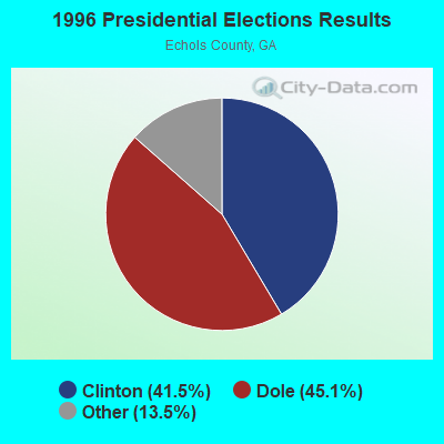


Graphs represent county-level data. Detailed 2008 Election Results
Religion statistics for Statenville, GA (based on Echols County data)

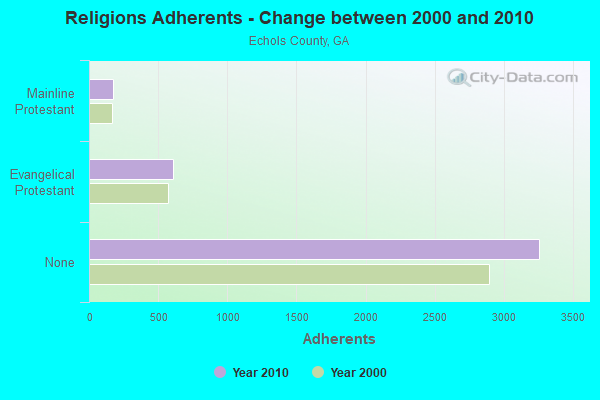
| Religion | Adherents | Congregations |
|---|---|---|
| Evangelical Protestant | 604 | 4 |
| Mainline Protestant | 172 | 2 |
| None | 3,258 | - |
Food Environment Statistics:
| This county: | 2.46 / 10,000 pop. |
| Georgia: | 5.12 / 10,000 pop. |
| Echols County: | 9.2% |
| Georgia: | 10.4% |
| Here: | 28.8% |
| Georgia: | 27.8% |
| Echols County: | 19.4% |
| State: | 14.6% |
Strongest AM radio stations in Statenville:
- WFVR (910 AM; 50 kW; VALDOSTA, GA; Owner: RAMA COMMUNICATIONS, INC.)
- WJEM (1150 AM; 5 kW; VALDOSTA, GA; Owner: WJEM, INC.)
- WOKV (690 AM; 50 kW; JACKSONVILLE, FL; Owner: COX RADIO, INC.)
- WTHV (810 AM; daytime; 2 kW; HAHIRA, GA; Owner: ETERNAL LIFE MINISTRIES, INC.)
- WGOV (950 AM; 4 kW; VALDOSTA, GA; Owner: W G O V, INC.)
- WSTT (730 AM; 25 kW; THOMASVILLE, GA; Owner: MARION R. WILLIAMS)
- WOBS (1530 AM; daytime; 50 kW; JACKSONVILLE, FL; Owner: WORD BROADCASTING NETWORK, INC.)
- WGSR (1570 AM; 50 kW; FERNANDINA BEACH, FL; Owner: RJM COMMUNICATIONS, INC)
- WHGH (840 AM; daytime; 10 kW; THOMASVILLE, GA; Owner: H. G. H INVESTMENT CORP.)
- WMGA (1130 AM; 10 kW; MOULTRIE, GA; Owner: RADIO MOULTRIE, INC.)
- WJEP (1020 AM; daytime; 10 kW; OCHLOCKNEE, GA; Owner: LIFELINE MINISTRIES, INCORPORATED)
- WFLF (540 AM; 50 kW; PINE HILLS, FL; Owner: CLEAR CHANNEL BROADCASTING LICENSES, INC.)
- WMAC (940 AM; 50 kW; MACON, GA; Owner: CUMULUS LICENSING CORP.)
Strongest FM radio stations in Statenville:
- WQPW (95.7 FM; VALDOSTA, GA; Owner: RTG RADIO, LLC)
- WHLJ (97.5 FM; STATENVILLE, GA; Owner: LATAURUS PRODUCTIONS INCORPORATED)
- WVHT (105.7 FM; MONTICELLO, FL; Owner: WILSON BROADCASTING, INC.)
- WWRQ-FM (107.9 FM; VALDOSTA, GA; Owner: RTG RADIO, LLC)
- WAAC (92.9 FM; VALDOSTA, GA; Owner: WGOV, INC.)
- WDMG-FM (99.5 FM; DOUGLAS, GA; Owner: RTG RADIO, LLC)
- WAFT (101.1 FM; VALDOSTA, GA; Owner: CHRISTIAN RADIO FELLOWSHIP, INC.)
- WYZK (96.7 FM; VALDOSTA, GA; Owner: C. D. J., INC.)
- WXHT (102.7 FM; MADISON, FL; Owner: MAGNUM BROADCASTING, INC.)
- WJYF (95.3 FM; NASHVILLE, GA; Owner: TIFTON BROADCASTING CORP.)
- WWET (91.7 FM; VALDOSTA, GA; Owner: GEORGIA PUBLIC TELECOMMUNICATIONS COMMISSION)
- WVGA (105.9 FM; LAKELAND, GA; Owner: RTG RADIO, LLC)
- WSTI-FM (105.3 FM; QUITMAN, GA; Owner: MAGNUM BROADCASTING, INC.)
TV broadcast stations around Statenville:
- WFXU (Channel 57; LIVE OAK, FL; Owner: WFXU LICENSE CORPORATION)
- WBFL-CA (Channel 13; VALDOSTA, GA; Owner: WTLH LICENSE CORP.)
- WCTV (Channel 6; THOMASVILLE, GA; Owner: WCTV LICENSEE CORP.)
- WTWC-TV (Channel 40; TALLAHASSEE, FL; Owner: WTWC LICENSEE, LLC)
- WLCF-LP (Channel 11; LAKE CITY, FL; Owner: BUDD BROADCASTING COMPANY, INC.)
- WVAG (Channel 44; VALDOSTA, GA; Owner: HUTCHENS COMMUNICATIONS, INC.)
- W25CP (Channel 25; VALDOSTA, GA; Owner: TRINITY BROADCASTING NETWORK)
- WBVJ-LP (Channel 35; VALDOSTA, GA; Owner: WTLH LICENSE CORP.)
Statenville fatal accident list:
May 24, 2014 10:16 AM, Sr-11, Lat: 30.709400, Lon: -83.027156, Vehicles: 2, Persons: 3, Fatalities: 1, Drunk persons involved: 1
Oct 16, 2009 08:59 PM, Sr-94, Lat: 30.703444, Lon: -83.028059, Vehicles: 1, Persons: 1, Fatalities: 1, Drunk persons involved: 1
Apr 24, 2006 08:23 PM, Sr-11, Lat: 30.702080, Lon: -83.028050, Vehicles: 2, Persons: 1, Fatalities: 1
Oct 21, 1993 05:00 PM, Sr94, Vehicles: 1, Persons: 1, Fatalities: 1, Drunk persons involved: 1
- National Bridge Inventory (NBI) Statistics
- 6Number of bridges
- 75ft / 22.8mTotal length
- $4,384,000Total costs
- 9,290Total average daily traffic
- 258Total average daily truck traffic
- 13,935Total future (year 2032) average daily traffic
FCC Registered Cell Phone Towers:
1 (See the full list of FCC Registered Cell Phone Towers in Statenville)FCC Registered Antenna Towers:
13 (See the full list of FCC Registered Antenna Towers)FCC Registered Broadcast Land Mobile Towers:
1- 207 Hwy 129 North (Lat: 30.707583 Lon: -83.029222), Type: Gtower, Structure height: 34 m, Overall height: 38 m, Call Sign: KIJ636,
Assigned Frequencies: 159.277 MHz, 154.280 MHz, 159.255 MHz, 151.145 MHz, 151.100 MHz, 151.115 MHz, 159.270 MHz, 159.285 MHz, 159.330 MHz, 159.360 MHz, 159.390 MHz, Grant Date: 10/26/2022, Expiration Date: 11/17/2032, Registrant: Gta Gfc Echols Unit, 5645 Riggins Mill Rd, Dry Branch, GA 31020, Phone: (478) 751-3494, Email:
2007 - 2018 National Fire Incident Reporting System (NFIRS) incidents
- Fire incident types reported to NFIRS in Statenville, GA
- 13465.7%Outside Fires
- 3718.1%Structure Fires
- 3215.7%Mobile Property/Vehicle Fires
- 10.5%Other
 According to the data from the years 2007 - 2018 the average number of fire incidents per year is 17. The highest number of reported fires - 44 took place in 2017, and the least - 0 in 2010. The data has a declining trend.
 When looking into fire subcategories, the most reports belonged to: Outside Fires (65.7%), and Structure Fires (18.1%).
- 85.9%Electricity
- 7.3%Bottled, tank, or LP gas
- 3.0%Fuel oil, kerosene, etc.
- 2.1%Utility gas
- 1.7%Wood

- 86.7%Electricity
- 13.3%Bottled, tank, or LP gas
Statenville compared to Georgia state average:
- Median house value significantly below state average.
- Unemployed percentage significantly below state average.
- Black race population percentage significantly below state average.
- Hispanic race population percentage significantly above state average.
- Median age significantly below state average.
- Foreign-born population percentage above state average.
- Length of stay since moving in below state average.
- Percentage of population with a bachelor's degree or higher significantly below state average.
Statenville on our top lists:
- #38 on the list of "Top 101 cities with the most residents born in Honduras (population 500+)"
- #71 (31648) on the list of "Top 101 zip codes with the largest percentage of Irish first ancestries"
- #40 on the list of "Top 101 counties with the lowest total withdrawal of fresh water for public supply"