Tripp, Wisconsin
Submit your own pictures of this town and show them to the world
- OSM Map
- Google Map
- MSN Map
Population change since 2000: +10.5%
 |
| Males: 114 | |
| Females: 117 |
| Median resident age: | 42.5 years |
| Wisconsin median age: | 42.6 years |
Zip codes: 54847.
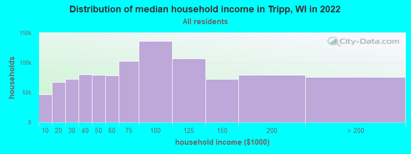
| Tripp: | $69,087 |
| WI: | $70,996 |
Estimated per capita income in 2022: $30,467 (it was $12,653 in 2000)
Tripp town income, earnings, and wages data
Estimated median house or condo value in 2022: $192,202 (it was $71,700 in 2000)
| Tripp: | $192,202 |
| WI: | $252,800 |
Mean prices in 2022: all housing units: $283,251; detached houses: $295,093; townhouses or other attached units: $452,863; in 2-unit structures: $274,116; in 3-to-4-unit structures: $123,082; in 5-or-more-unit structures: $339,992; mobile homes: $87,640; occupied boats, rvs, vans, etc.: $120,329
Detailed information about poverty and poor residents in Tripp, WI
Compare current foreclosures near Tripp, WI:
| Photo | Address | Area | Beds / Baths | Price | Details |
|---|---|---|---|---|---|

|
#1
Motel Rd
Mason, WI 54856
|
- sq. feet
|
- baths - beds |
show details | |

|
#2
Erkilla Rd
Brule, WI 54820
|
- sq. feet
|
- baths - beds |
show details | |

|
#3
Old 13 Rd
Port Wing, WI 54865
|
- sq. feet
|
- baths - beds |
show details | |

|
#4
Us Highway 2
Mason, WI 54856
|
- sq. feet
|
- baths - beds |
show details | |

|
Check over 1 million property listings on Foreclosure.com!
|
browse all offers | |||

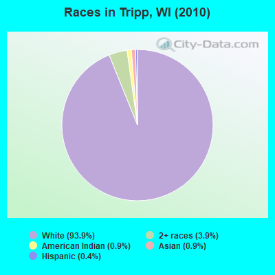
- 21793.9%White alone
- 93.9%Two or more races
- 20.9%American Indian alone
- 20.9%Asian alone
- 10.4%Hispanic
Races in Tripp detailed stats: ancestries, foreign born residents, place of birth
 Recent articles from our blog. Our writers, many of them Ph.D. graduates or candidates, create easy-to-read articles on a wide variety of topics.

Ancestries: German (26.3%), Irish (8.1%), English (7.2%), Swedish (5.3%), French (4.8%), Dutch (3.8%).
Current Local Time: CST time zone
Land area: 34.7 square miles.
Population density: 6.7 people per square mile (very low).
4 residents are foreign born
| This town: | 1.9% |
| Wisconsin: | 3.6% |
| Tripp town: | 1.6% ($1,167) |
| Wisconsin: | 2.0% ($2,245) |
Nearest city with pop. 50,000+: Duluth, MN  (37.5 miles , pop. 86,918).
Nearest city with pop. 200,000+: St. Paul, MN (142.7 miles , pop. 287,151).
Nearest city with pop. 1,000,000+: Chicago, IL (377.4 miles , pop. 2,896,016).
Nearest cities:
), ), ), ), ), )Latitude: 46.62 N, Longitude: 91.36 W
Area code commonly used in this area: 715
| Here: | 4.8% |
| Wisconsin: | 2.7% |
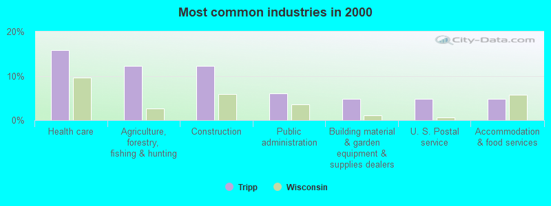
- Health care (15.9%)
- Agriculture, forestry, fishing & hunting (12.2%)
- Construction (12.2%)
- Public administration (6.1%)
- Building material & garden equipment & supplies dealers (4.9%)
- U. S. Postal service (4.9%)
- Accommodation & food services (4.9%)
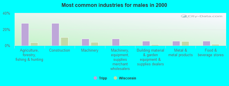
- Agriculture, forestry, fishing & hunting (27.8%)
- Construction (27.8%)
- Machinery (8.3%)
- Machinery, equipment, supplies merchant wholesalers (8.3%)
- Building material & garden equipment & supplies dealers (5.6%)
- Metal & metal products (5.6%)
- Food & beverage stores (5.6%)
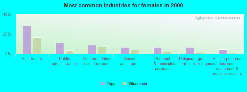
- Health care (28.3%)
- Public administration (10.9%)
- Accommodation & food services (8.7%)
- Social assistance (6.5%)
- Personal & laundry services (6.5%)
- Religious, grantmaking, civic, professional, similar organizations (6.5%)
- Building material & garden equipment & supplies dealers (4.3%)
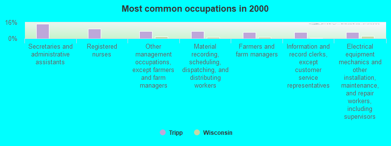
- Secretaries and administrative assistants (14.6%)
- Registered nurses (9.8%)
- Other management occupations, except farmers and farm managers (7.3%)
- Material recording, scheduling, dispatching, and distributing workers (7.3%)
- Farmers and farm managers (6.1%)
- Information and record clerks, except customer service representatives (6.1%)
- Electrical equipment mechanics and other installation, maintenance, and repair workers, including supervisors (6.1%)
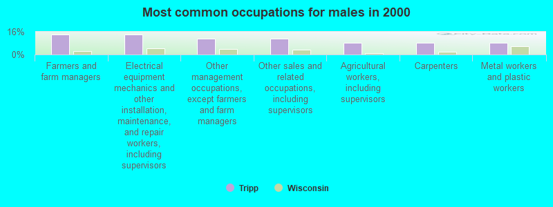
- Farmers and farm managers (13.9%)
- Electrical equipment mechanics and other installation, maintenance, and repair workers, including supervisors (13.9%)
- Other management occupations, except farmers and farm managers (11.1%)
- Other sales and related occupations, including supervisors (11.1%)
- Agricultural workers, including supervisors (8.3%)
- Carpenters (8.3%)
- Metal workers and plastic workers (8.3%)
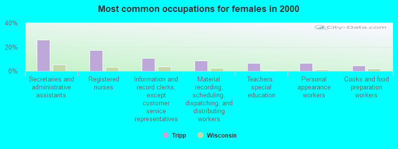
- Secretaries and administrative assistants (26.1%)
- Registered nurses (17.4%)
- Information and record clerks, except customer service representatives (10.9%)
- Material recording, scheduling, dispatching, and distributing workers (8.7%)
- Teachers, special education (6.5%)
- Personal appearance workers (6.5%)
- Cooks and food preparation workers (4.3%)
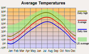
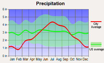
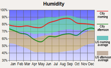
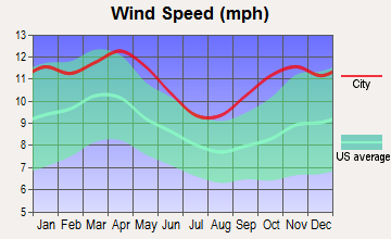
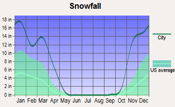
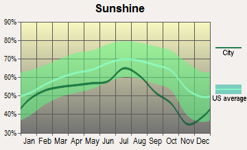
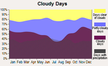
Average climate in Tripp, Wisconsin
Based on data reported by over 4,000 weather stations
Tornado activity:
Tripp-area historical tornado activity is significantly below Wisconsin state average. It is 78% smaller than the overall U.S. average.
On 8/6/1969, a category F3 (max. wind speeds 158-206 mph) tornado 33.1 miles away from the Tripp town center killed 2 people and injured 3 people and caused between $50,000 and $500,000 in damages.
On 9/3/1980, a category F2 (max. wind speeds 113-157 mph) tornado 17.5 miles away from the town center caused between $5000 and $50,000 in damages.
Earthquake activity:
Tripp-area historical earthquake activity is significantly above Wisconsin state average. It is 70% smaller than the overall U.S. average.On 7/9/1975 at 14:54:15, a magnitude 4.6 (4.6 MB, Class: Light, Intensity: IV - V) earthquake occurred 233.6 miles away from Tripp center
On 2/7/2020 at 18:30:28, a magnitude 3.3 (3.3 ML, Class: Light, Intensity: II - III) earthquake occurred 87.6 miles away from Tripp center
On 4/8/2020 at 17:14:33, a magnitude 3.3 (3.3 ML) earthquake occurred 89.2 miles away from Tripp center
On 1/9/2020 at 18:16:48, a magnitude 3.3 (3.3 MB) earthquake occurred 89.4 miles away from the city center
On 3/2/2017 at 16:53:31, a magnitude 3.2 (3.2 ML) earthquake occurred 75.5 miles away from the city center
On 6/5/1993 at 01:24:53, a magnitude 4.1 (4.1 LG, Depth: 6.2 mi) earthquake occurred 245.1 miles away from Tripp center
Magnitude types: regional Lg-wave magnitude (LG), body-wave magnitude (MB), local magnitude (ML)
Natural disasters:
The number of natural disasters in Bayfield County (10) is smaller than the US average (15).Major Disasters (Presidential) Declared: 8
Emergencies Declared: 2
Causes of natural disasters: Floods: 7, Storms: 5, Winds: 2, Drought: 1, Heavy Rain: 1, Hurricane: 1, Mudslide: 1, Other: 1 (Note: some incidents may be assigned to more than one category).
Colleges/universities with over 2000 students nearest to Tripp:
- University of Wisconsin-Superior (about 36 miles; Superior, WI; Full-time enrollment: 2,302)
- University of Minnesota-Duluth (about 37 miles; Duluth, MN; FT enrollment: 10,612)
- The College of Saint Scholastica (about 38 miles; Duluth, MN; FT enrollment: 3,762)
- Lake Superior College (about 39 miles; Duluth, MN; FT enrollment: 3,768)
- Wisconsin Indianhead Technical College (about 66 miles; Shell Lake, WI; FT enrollment: 2,414)
- University of Wisconsin-Stout (about 123 miles; Menomonie, WI; FT enrollment: 8,120)
- University of Wisconsin-Eau Claire (about 127 miles; Eau Claire, WI; FT enrollment: 10,143)
Points of interest:
Notable locations in Tripp: Iron River National Fish Hatchery (A), Tripp Townhall (B). Display/hide their locations on the map
Cemetery: Valley View Cemetery (1). Display/hide its location on the map
Lakes: Silver Sack Lake (A), Bailey Lake (B), Jackman Lake (C). Display/hide their locations on the map
Creeks: Hill Creek (A), Middle Creek (B), DeChamps Creek (C), Townsend Creek (D), Schacte Creek (E). Display/hide their locations on the map
| This town: | 2.5 people |
| Wisconsin: | 2.4 people |
| This town: | 70.3% |
| Whole state: | 64.4% |
| This town: | 14.3% |
| Whole state: | 7.3% |
No gay or lesbian households reported
| This town: | 6.3% |
| Whole state: | 8.7% |
| This town: | 1.1% |
| Whole state: | 3.7% |
For population 15 years and over in Tripp:
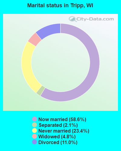
- Never married: 23.4%
- Now married: 58.6%
- Separated: 2.1%
- Widowed: 4.8%
- Divorced: 11.0%
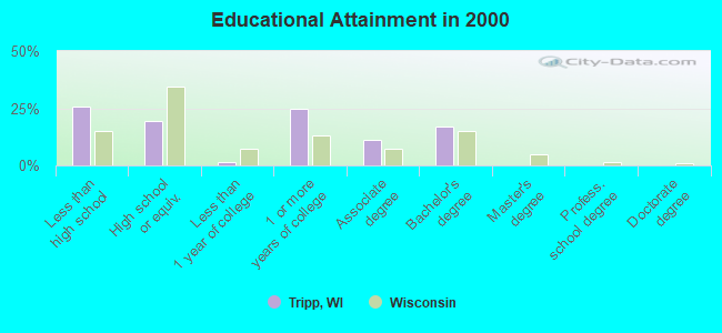
For population 25 years and over in Tripp:
- High school or higher: 74.2%
- Bachelor's degree or higher: 16.9%
- Graduate or professional degree: 0.0%
- Unemployed: 16.3%
- Mean travel time to work (commute): 23.6 minutes
| Here: | 9.8 |
| Wisconsin average: | 11.0 |
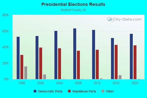
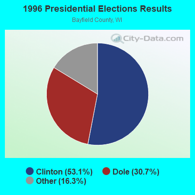
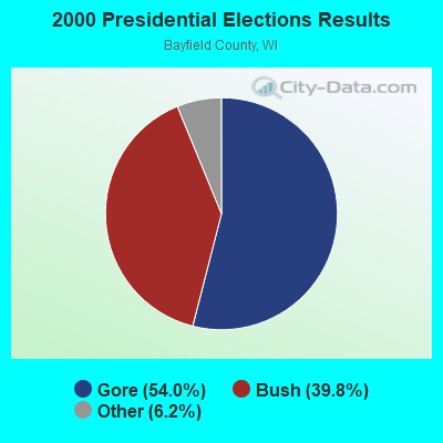
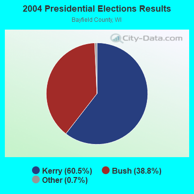
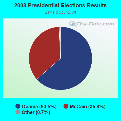
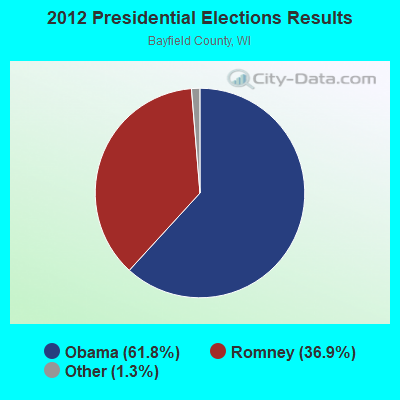
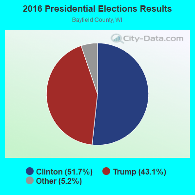
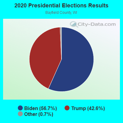
Graphs represent county-level data. Detailed 2008 Election Results
Religion statistics for Tripp, WI (based on Bayfield County data)
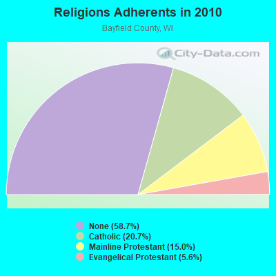
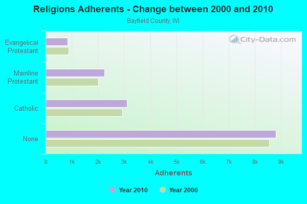
| Religion | Adherents | Congregations |
|---|---|---|
| Catholic | 3,109 | 10 |
| Mainline Protestant | 2,247 | 14 |
| Evangelical Protestant | 847 | 10 |
| Other | 1 | 1 |
| Orthodox | - | - |
| None | 8,810 | - |
Food Environment Statistics:
| This county: | 3.32 / 10,000 pop. |
| State: | 1.86 / 10,000 pop. |
| Bayfield County: | 8.63 / 10,000 pop. |
| Wisconsin: | 4.12 / 10,000 pop. |
| Bayfield County: | 26.56 / 10,000 pop. |
| Wisconsin: | 8.64 / 10,000 pop. |
| Bayfield County: | 8.7% |
| Wisconsin: | 7.6% |
| Bayfield County: | 27.6% |
| Wisconsin: | 27.5% |
| Bayfield County: | 14.3% |
| State: | 13.0% |
Strongest AM radio stations in Tripp:
- WEBC (560 AM; 50 kW; DULUTH, MN)
- WDSM (710 AM; 10 kW; SUPERIOR, WI; Owner: MIDWEST COMMUNICATIONS, INC.)
- WWJC (850 AM; daytime; 10 kW; DULUTH, MN; Owner: WWJC, INC.)
- KDAL (610 AM; 5 kW; DULUTH, MN; Owner: MIDWEST COMMUNICATIONS, INC.)
- WCCO (830 AM; 50 kW; MINNEAPOLIS, MN; Owner: INFINITY MEDIA CORPORATION)
- WHSM (910 AM; 5 kW; HAYWARD, WI; Owner: QB BROADCASTING, LTD.)
- WJMS (590 AM; 5 kW; IRONWOOD, MI; Owner: ROBERTS BROADCASTING, INC.)
- WCTS (1030 AM; 50 kW; MAPLEWOOD, MN; Owner: CNTL. BAPT. THEO/AL SEMI MINNEAPOLIS)
- KSTP (1500 AM; 50 kW; ST. PAUL, MN; Owner: KSTP-AM, LLC (DELAWARE))
- WSPT (1010 AM; 50 kW; STEVENS POINT, WI)
- WNMT (650 AM; 10 kW; NASHWAUK, MN; Owner: MIDWEST RADIO NETWORK, L.L.C.)
- KFAN (1130 AM; 50 kW; MINNEAPOLIS, MN; Owner: AMFM RADIO LICENSES, L.L.C.)
- WSAU (550 AM; 20 kW; WAUSAU, WI; Owner: WRIG, INC.)
Strongest FM radio stations in Tripp:
- WNXR (107.3 FM; IRON RIVER, WI; Owner: GERALD J. HACKMAN)
- WHSA (89.9 FM; BRULE, WI; Owner: STATE OF WISCONSIN - EDUCATIONAL COMMUNICATIONS BOARD)
- WEGZ (105.9 FM; WASHBURN, WI; Owner: KEWEENAW BAY BROADCASTING, INC.)
- KBMX (107.7 FM; PROCTOR, MN; Owner: REGENT BROADCASTING OF DULUTH, INC.)
- WWAX (92.1 FM; HERMANTOWN, MN; Owner: RED ROCK RADIO CORP.)
- WSCN (100.5 FM; CLOQUET, MN; Owner: MINNESOTA PUBLIC RADIO)
- KDNI (90.5 FM; DULUTH, MN; Owner: NORTHWESTERN COLLEGE)
- KQDS-FM (94.9 FM; DULUTH, MN; Owner: RED ROCK RADIO CORP.)
- KLDJ (101.7 FM; DULUTH, MN; Owner: REGENT BROADCASTING OF DULUTH, INC.)
- KUMD-FM (103.3 FM; DULUTH, MN; Owner: REGENTS OF UNIVERSITY OF MINNESOTA)
- KDAL-FM (95.7 FM; DULUTH, MN; Owner: MIDWEST COMMUNICATIONS, INC.)
- KKCB (105.1 FM; DULUTH, MN; Owner: REGENT BROADCASTING OF DULUTH, INC.)
- WJJH (96.7 FM; ASHLAND, WI; Owner: BAY BROADCASTING CORPORATION)
TV broadcast stations around Tripp:
- WDIO-TV (Channel 10; DULUTH, MN; Owner: WDIO-TV, LLC)
- KDLH (Channel 3; DULUTH, MN; Owner: CHELSEY BROADCASTING COMPANY OF DULUTH, LLC)
- KBJR-TV (Channel 6; SUPERIOR, WI; Owner: KBJR LICENSE, INC.)
- KQDS-TV (Channel 21; DULUTH, MN; Owner: KQDS ACQUISITION CORP.)
- WAST-LP (Channel 25; ASHLAND, WI; Owner: RESOURCE RECOVERY OF WISCONSIN, INC.)
- WDSE-TV (Channel 8; DULUTH, MN; Owner: DULUTH-SUPERIOR AREA EDUCATIONAL TV CORPORATION)
- National Bridge Inventory (NBI) Statistics
- 4Number of bridges
- 16ft / 5.1mTotal length
- 2,669Total average daily traffic
- 2,935Total future (year 2035) average daily traffic
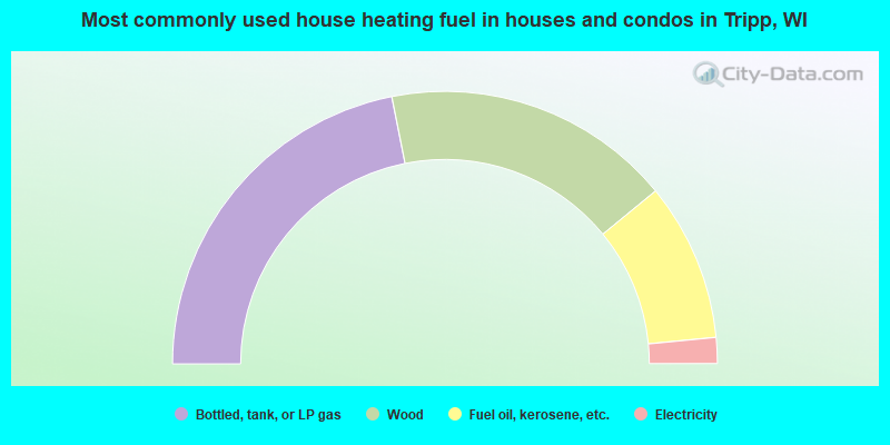
- 43.8%Bottled, tank, or LP gas
- 34.4%Wood
- 18.8%Fuel oil, kerosene, etc.
- 3.1%Electricity
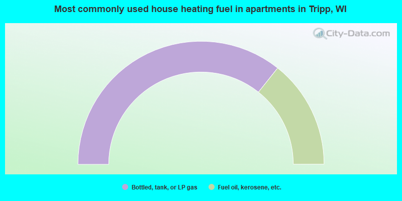
- 71.4%Bottled, tank, or LP gas
- 28.6%Fuel oil, kerosene, etc.
Tripp compared to Wisconsin state average:
- Black race population percentage significantly below state average.
- Hispanic race population percentage significantly below state average.
- Foreign-born population percentage significantly below state average.
- Renting percentage below state average.
- Length of stay since moving in significantly above state average.
- Number of rooms per house significantly below state average.
- House age significantly below state average.
- Number of college students significantly below state average.