Waynesville, Georgia
Submit your own pictures of this place and show them to the world
- OSM Map
- General Map
- Google Map
- MSN Map

| Males: 2,825 | |
| Females: 2,679 |
| Median resident age: | 33.2 years |
| Georgia median age: | 33.4 years |
Zip code: 31543
| Waynesville: | $42,482 |
| GA: | $72,837 |
Estimated per capita income in 2022: $21,881 (it was $12,993 in 2000)
Waynesville CCD income, earnings, and wages data
Estimated median house or condo value in 2022: $104,659 (it was $37,100 in 2000)
| Waynesville: | $104,659 |
| GA: | $297,400 |
Mean prices in 2022: all housing units: $170,249; detached houses: $228,085; mobile homes: $112,814; occupied boats, rvs, vans, etc.: $70,904
Detailed information about poverty and poor residents in Waynesville, GA


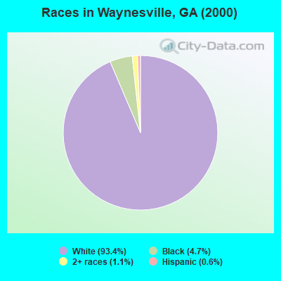
- 4,88593.4%White alone
- 2444.7%Black alone
- 601.1%Two or more races
- 340.6%Hispanic
- 40.08%American Indian alone
- 40.08%Asian alone
Races in Waynesville detailed stats: ancestries, foreign born residents, place of birth
According to our research of Georgia and other state lists, there were 17 registered sex offenders living in Waynesville, Georgia as of April 26, 2024.
The ratio of all residents to sex offenders in Waynesville is 324 to 1.
The ratio of registered sex offenders to all residents in this city is near the state average.
 Recent articles from our blog. Our writers, many of them Ph.D. graduates or candidates, create easy-to-read articles on a wide variety of topics.

Current Local Time: EST time zone
Elevation: 57 feet
Land area: 113.2 square miles.
Population density: 49 people per square mile (very low).

| Waynesville CCD: | 1.3% ($493) |
| Georgia: | 0.9% ($919) |
Nearest city with pop. 50,000+: Jacksonville, FL  (65.5 miles , pop. 735,617).
Nearest city with pop. 1,000,000+: Philadelphia, PA (710.6 miles , pop. 1,517,550).
Nearest cities:
), ), ), )Latitude: 31.26 N, Longitude: 81.81 W
Area code: 912

| Here: | 3.1% |
| Georgia: | 2.9% |
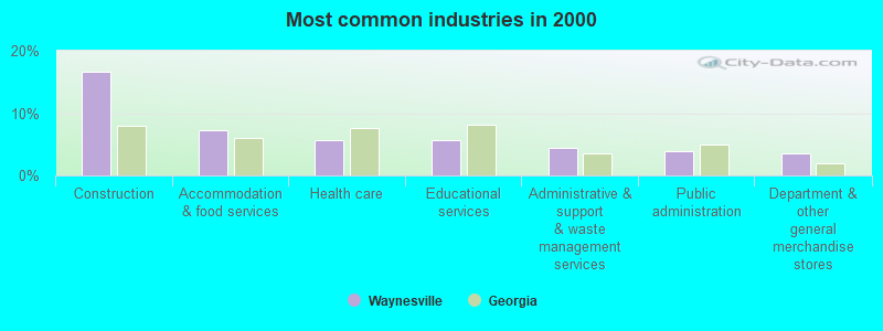
- Construction (16.6%)
- Accommodation & food services (7.2%)
- Health care (5.6%)
- Educational services (5.6%)
- Administrative & support & waste management services (4.5%)
- Public administration (3.9%)
- Department & other general merchandise stores (3.6%)

- Construction (27.1%)
- Agriculture, forestry, fishing & hunting (6.0%)
- Public administration (5.2%)
- Paper (4.9%)
- Machinery (4.6%)
- Repair & maintenance (4.1%)
- Chemicals (3.9%)
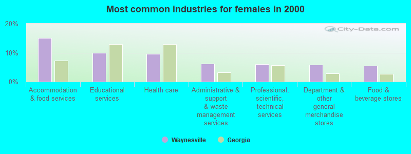
- Accommodation & food services (15.0%)
- Educational services (9.9%)
- Health care (9.6%)
- Administrative & support & waste management services (6.3%)
- Professional, scientific, technical services (6.0%)
- Department & other general merchandise stores (5.8%)
- Food & beverage stores (5.5%)
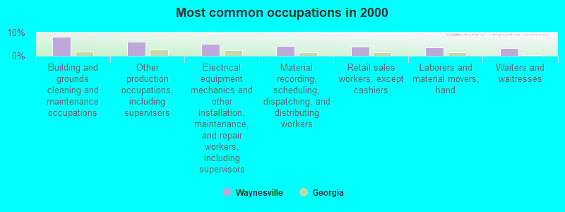
- Building and grounds cleaning and maintenance occupations (8.3%)
- Other production occupations, including supervisors (6.0%)
- Electrical equipment mechanics and other installation, maintenance, and repair workers, including supervisors (5.1%)
- Material recording, scheduling, dispatching, and distributing workers (4.4%)
- Retail sales workers, except cashiers (4.1%)
- Laborers and material movers, hand (3.6%)
- Waiters and waitresses (3.3%)
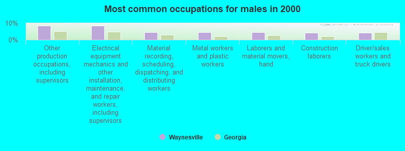
- Other production occupations, including supervisors (8.6%)
- Electrical equipment mechanics and other installation, maintenance, and repair workers, including supervisors (8.5%)
- Material recording, scheduling, dispatching, and distributing workers (4.7%)
- Metal workers and plastic workers (4.6%)
- Laborers and material movers, hand (4.6%)
- Construction laborers (4.4%)
- Driver/sales workers and truck drivers (4.3%)

- Building and grounds cleaning and maintenance occupations (15.2%)
- Retail sales workers, except cashiers (7.0%)
- Cashiers (7.0%)
- Waiters and waitresses (6.8%)
- Bookkeeping, accounting, and auditing clerks (4.9%)
- Material recording, scheduling, dispatching, and distributing workers (3.9%)
- Preschool, kindergarten, elementary, and middle school teachers (3.8%)
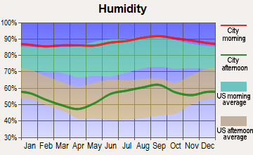
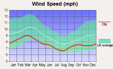
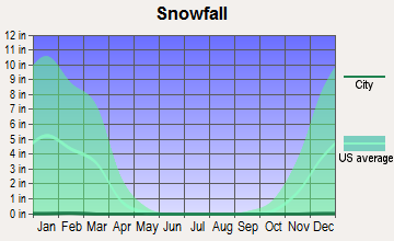
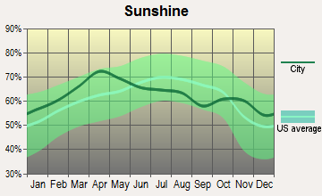
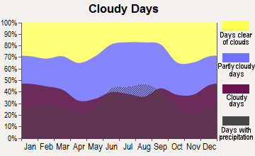
Average climate in Waynesville, Georgia
Based on data reported by over 4,000 weather stations
(lower is better)
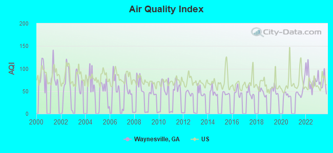
Air Quality Index (AQI) level in 2023 was 70.1. This is about average.
| City: | 70.1 |
| U.S.: | 72.6 |
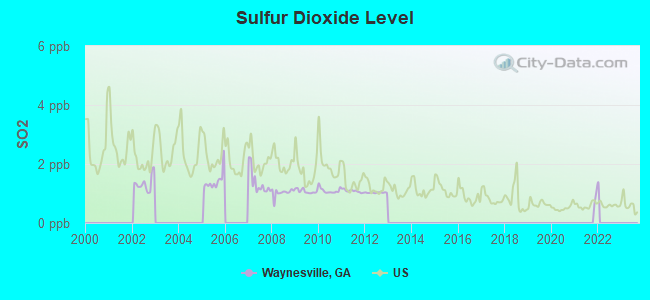
Sulfur Dioxide (SO2) [ppb] level in 2012 was 1.03. This is significantly better than average. Closest monitor was 17.2 miles away from the city center.
| City: | 1.03 |
| U.S.: | 1.51 |
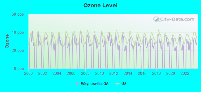
Ozone [ppb] level in 2023 was 30.5. This is about average. Closest monitor was 19.4 miles away from the city center.
| City: | 30.5 |
| U.S.: | 33.3 |

Particulate Matter (PM2.5) [µg/m3] level in 2023 was 8.96. This is about average. Closest monitor was 18.6 miles away from the city center.
| City: | 8.96 |
| U.S.: | 8.11 |
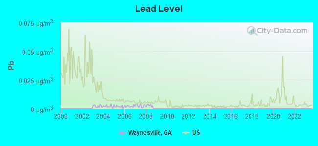
Lead (Pb) [µg/m3] level in 2008 was 0.00272. This is significantly better than average. Closest monitor was 19.7 miles away from the city center.
| City: | 0.00272 |
| U.S.: | 0.00931 |
Tornado activity:
Waynesville-area historical tornado activity is significantly below Georgia state average. It is 38% smaller than the overall U.S. average.
On 5/11/2008, a category F4 (max. wind speeds 207-260 mph) tornado 23.0 miles away from the Waynesville place center injured 9 people and caused $13 million in damages.
On 11/18/1968, a category F3 (max. wind speeds 158-206 mph) tornado 29.8 miles away from the place center caused between $5000 and $50,000 in damages.
Earthquake activity:
Waynesville-area historical earthquake activity is significantly above Georgia state average. It is 51% smaller than the overall U.S. average.On 8/2/1974 at 08:52:09, a magnitude 4.9 (4.3 MB, 4.9 LG, Class: Light, Intensity: IV - V) earthquake occurred 185.1 miles away from Waynesville center
On 11/22/1974 at 05:25:55, a magnitude 4.7 (4.7 MB) earthquake occurred 149.6 miles away from the city center
On 8/21/1992 at 16:31:55, a magnitude 4.4 (4.1 MB, 4.1 LG, 4.4 LG, Depth: 6.2 mi) earthquake occurred 158.6 miles away from the city center
On 11/11/2002 at 23:39:29, a magnitude 4.0 (4.0 MB, Depth: 1.5 mi) earthquake occurred 135.5 miles away from the city center
On 4/29/2003 at 08:59:39, a magnitude 4.9 (4.4 MB, 4.6 MW, 4.9 LG) earthquake occurred 315.2 miles away from the city center
On 7/13/2003 at 20:15:16, a magnitude 3.6 (3.6 MB, Depth: 3.1 mi, Class: Light, Intensity: II - III) earthquake occurred 77.1 miles away from the city center
Magnitude types: regional Lg-wave magnitude (LG), body-wave magnitude (MB), moment magnitude (MW)
Natural disasters:
The number of natural disasters in Brantley County (12) is smaller than the US average (15).Major Disasters (Presidential) Declared: 4
Emergencies Declared: 4
Causes of natural disasters: Hurricanes: 3, Storms: 3, Tornadoes: 3, Fires: 2, Floods: 2, Winds: 2, Drought: 1, Snowfall: 1, Tropical Storm: 1, Winter Storm: 1, Other: 1 (Note: some incidents may be assigned to more than one category).
Colleges/universities with over 2000 students nearest to Waynesville:
- College of Coastal Georgia (about 21 miles; Brunswick, GA; Full-time enrollment: 2,447)
- Armstrong Atlantic State University (about 63 miles; Savannah, GA; FT enrollment: 6,399)
- South Georgia State College (about 64 miles; Douglas, GA; FT enrollment: 2,507)
- Jacksonville University (about 64 miles; Jacksonville, FL; FT enrollment: 3,335)
- Florida State College at Jacksonville (about 65 miles; Jacksonville, FL; FT enrollment: 21,810)
- South University–Savannah Online (about 66 miles; Savannah, GA; FT enrollment: 13,512)
- Savannah Technical College (about 67 miles; Savannah, GA; FT enrollment: 3,677)
Public elementary/middle schools in Waynesville:
- WAYNESVILLE PRIMARY SCHOOL (Students: 756, Location: 5726 OLD WAYNESVILLE RD, Grades: PK-3)
- ATKINSON ELEMENTARY SCHOOL (Students: 278, Location: 4327 HIGHWAY 110 E, Grades: 4-6)
Points of interest:
Notable locations in Waynesville: Linda Plantation (A), Rosin Landing (B), Waynesville Volunteer Fire Department (C), Atkinson Volunteer Fire Department (D). Display/hide their locations on the map
Churches in Waynesville include: Waynesville Church (A), Old Time Church (B), Christian Fellowship Church (C), Atkinson Baptist Church (D), East Side Church (E), First African Church (F), Hope Chapel (G), Little Memorial (H), Little Rock Church (I). Display/hide their locations on the map
Cemeteries: Lane Cemetery (1), Ammons Cemetery (2), Arnett Cemetery (3), McCool Cemetery (4), Mount Olive Cemetery (5), Gibson Cemetery (6), Grayham Cemetery (7). Display/hide their locations on the map
Lakes, reservoirs, and swamps: Bonnett Lake (A), Sandy Lake (B), Ditch Lake (C), Doe Lake (D), Drurys Lake (E), Felton Lake (F), Julia Lake (G), Basin Lake (H). Display/hide their locations on the map
Streams, rivers, and creeks: Well Branch (A), Tenmile Swamp (B), Seals Branch (C), Harper Branch (D), Church House Branch (E), Page Branch (F), Barbers Creek (G), Back Branch (H), Mineral Branch (I). Display/hide their locations on the map
| This place: | 2.7 people |
| Georgia: | 2.6 people |
| This place: | 73.9% |
| Whole state: | 68.5% |
| This place: | 8.1% |
| Whole state: | 5.9% |
Likely homosexual households (counted as self-reported same-sex unmarried-partner households)
- Lesbian couples: 0.4% of all households
- Gay men: 0.2% of all households
| This place: | 15.8% |
| Whole state: | 13.0% |
| This place: | 4.4% |
| Whole state: | 6.1% |
For population 15 years and over in Waynesville:
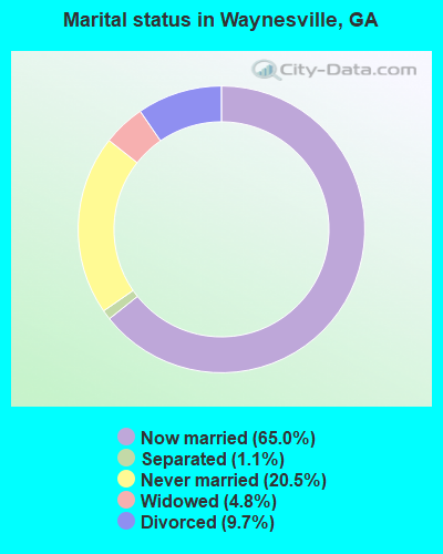
- Never married: 20.5%
- Now married: 65.0%
- Separated: 1.1%
- Widowed: 4.8%
- Divorced: 9.7%
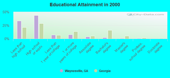
For population 25 years and over in Waynesville:
- High school or higher: 66.7%
- Bachelor's degree or higher: 4.4%
- Graduate or professional degree: 2.1%
- Unemployed: 6.2%
- Mean travel time to work (commute): 37.0 minutes

| Here: | 11.2 |
| Georgia average: | 13.3 |
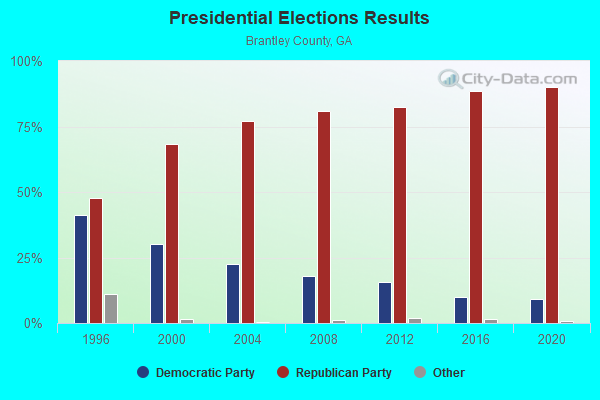
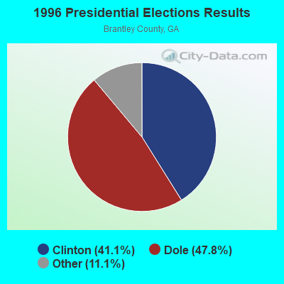
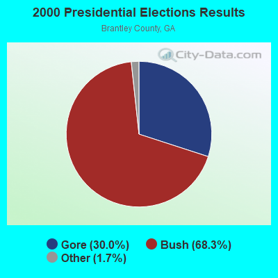

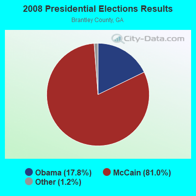
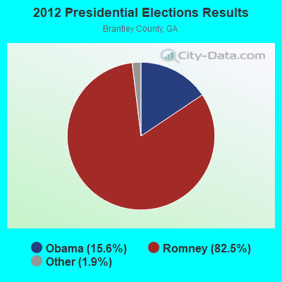
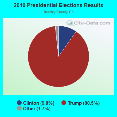

Graphs represent county-level data. Detailed 2008 Election Results
Religion statistics for Waynesville, GA (based on Brantley County data)
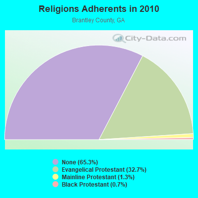
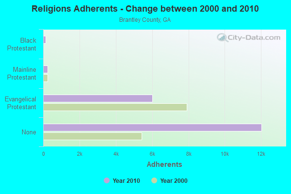
| Religion | Adherents | Congregations |
|---|---|---|
| Evangelical Protestant | 6,016 | 22 |
| Mainline Protestant | 239 | 4 |
| Black Protestant | 126 | 1 |
| Other | 1 | - |
| None | 12,029 | - |
Food Environment Statistics:
| This county: | 1.95 / 10,000 pop. |
| State: | 1.91 / 10,000 pop. |
| Brantley County: | 0.65 / 10,000 pop. |
| Georgia: | 0.86 / 10,000 pop. |
| Here: | 7.78 / 10,000 pop. |
| Georgia: | 5.12 / 10,000 pop. |
| Brantley County: | 3.89 / 10,000 pop. |
| Georgia: | 7.41 / 10,000 pop. |
| Brantley County: | 10.4% |
| State: | 10.4% |
| Brantley County: | 27.4% |
| State: | 27.8% |
| This county: | 9.9% |
| Georgia: | 14.6% |
Businesses in Waynesville, GA
- Domino's Pizza: 1
- FedEx: 1
- UPS: 1
Strongest AM radio stations in Waynesville:
- WCGA (1100 AM; daytime; 10 kW; WOODBINE, GA; Owner: COX BROADCAST GROUP, INC.)
- WOKV (690 AM; 50 kW; JACKSONVILLE, FL; Owner: COX RADIO, INC.)
- WSFN (790 AM; 2 kW; BRUNSWICK, GA)
- WGIG (1440 AM; 5 kW; BRUNSWICK, GA)
- WOBS (1530 AM; daytime; 50 kW; JACKSONVILLE, FL; Owner: WORD BROADCASTING NETWORK, INC.)
- WFVR (910 AM; 50 kW; VALDOSTA, GA; Owner: RAMA COMMUNICATIONS, INC.)
- WLOP (1370 AM; 5 kW; JESUP, GA; Owner: JESUP BROADCASTING CORP.)
- WGSR (1570 AM; 50 kW; FERNANDINA BEACH, FL; Owner: RJM COMMUNICATIONS, INC)
- WFNS (1350 AM; 2 kW; BLACKSHEAR, GA; Owner: MARMAC COMMUNICATIONS, LLC)
- WFLF (540 AM; 50 kW; PINE HILLS, FL; Owner: CLEAR CHANNEL BROADCASTING LICENSES, INC.)
- WIOJ (1010 AM; 10 kW; JACKSONVILLE BEACH, FL)
- WMAC (940 AM; 50 kW; MACON, GA; Owner: CUMULUS LICENSING CORP.)
- WBWL (600 AM; 5 kW; JACKSONVILLE, FL)
Strongest FM radio stations in Waynesville:
- WWSN (103.3 FM; WAYCROSS, GA; Owner: QANTUM OF BRUNSWICK LICENSE COMPANY, LLC)
- WYNR (102.5 FM; WAYCROSS, GA; Owner: QANTUM OF BRUNSWICK LICENSE COMPANY, LLC)
- WSOL-FM (101.5 FM; BRUNSWICK, GA; Owner: CITICASTERS LICENSES, L.P.)
- WWRR (100.7 FM; BRUNSWICK, GA; Owner: RENDA BROADCASTING CORP. OF NEVADA)
- WBGA (107.7 FM; DARIEN, GA; Owner: QANTUM OF BRUNSWICK LICENSE COMPANY, LLC)
- WXMK (105.9 FM; DOCK JUNCTION, GA; Owner: GOLDEN ISLES BROADCASTING, LLC)
- WLPT (88.3 FM; JESUP, GA; Owner: AUGUSTA RADIO FELLOWSHIP INSTITUTE, INC.)
- WGCO (98.3 FM; MIDWAY, GA; Owner: MONTEREY LICENSES, LLC)
- WRJY (104.1 FM; BRUNSWICK, GA; Owner: GOLDEN ISLES BROADCASTING, LLC)
- WECC-FM (89.3 FM; FOLKSTON, GA; Owner: LIGHTHOUSE CHRISTIAN BROADCASTING CORP.)
- WAYR-FM (90.7 FM; BRUNSWICK, GA; Owner: GOOD TIDINGS TRUST, INC)
- WHFX (92.7 FM; ST. SIMONS ISLAND, GA; Owner: QANTUM OF BRUNSWICK LICENSE COMPANY, LLC)
- WOKF (92.5 FM; FOLKSTON, GA; Owner: CENTRAL FLORIDA COMMUNICATIONS GROUP, INC.)
- W220DH (91.9 FM; BRUNSWICK, GA; Owner: CALVARY CHAPEL OF TWIN FALLS, INC.)
- W229AF (90.5 FM; BRUNSWICK, GA; Owner: FAMILY STATIONS, INC.)
TV broadcast stations around Waynesville:
- WPXC-TV (Channel 21; BRUNSWICK, GA; Owner: PAXSON JAX LICENSE, INC.)
- WGSA (Channel 34; BAXLEY, GA; Owner: SOUTHERN TV CORPORATION)
- W33AL (Channel 33; BRUNSWICK, GA; Owner: TRINITY BROADCASTING NETWORK)

Waynesville fatal accident list:
Mar 11, 2013 10:44 AM, Sr-110, Lat: 31.250036, Lon: -81.848036, Vehicles: 1, Persons: 1, Pedestrians: 1, Fatalities: 1
FCC Registered Cell Phone Towers:
2 (See the full list of FCC Registered Cell Phone Towers in Waynesville)FCC Registered Antenna Towers:
19 (See the full list of FCC Registered Antenna Towers)FCC Registered Broadcast Land Mobile Towers:
3- 2 Mi W (Lat: 31.225222 Lon: -81.824000), Call Sign: KIF216,
Assigned Frequencies: 159.360 MHz, 159.390 MHz, Grant Date: 09/19/2023, Expiration Date: 10/03/2033, Registrant: Gta Gfc Brantley Unit, 5645 Riggins Mill Road, Dry Branch, GA 31020, Phone: (478) 751-3494, Email:
- WAYNESVILLE, .23 Miles North Of Intersection Of Us Highway 82 And Browntown Rd. (Lat: 31.232333 Lon: -81.789861), Type: Gtower, Structure height: 57.9 m, Overall height: 60.6 m, Call Sign: WPBP467,
Assigned Frequencies: 155.145 MHz, Grant Date: 09/29/2014, Expiration Date: 08/09/2024, Certifier: Timothy P Crews, Registrant: Monroe Communications, 570 Pafford Road, Waycross, GA 31501, Phone: (912) 285-8491, Fax: (912) 285-0647, Email:
- 3.1 M S Of Int Of Hwy 32 & Old Post Rd (Lat: 31.270778 Lon: -81.751778), Call Sign: KNBR549,
Assigned Frequencies: 153.185 MHz, Grant Date: 09/05/1996, Expiration Date: 10/01/2001, Cancellation Date: 03/03/2002, Registrant: Murray Logging Co Inc, 133 Highland Park Dr, Brunswick, GA 31520, Phone: (912) 264-8274
FCC Registered Microwave Towers:
2- WAYNESVILLE, 6260 Highway 110 East (Lat: 31.215111 Lon: -81.838000), Type: Mast, Structure height: 91.4 m, Overall height: 95.7 m, Call Sign: WPNB335,
Assigned Frequencies: 6786.25 MHz, Grant Date: 03/02/2011, Expiration Date: 02/01/2021, Cancellation Date: 10/25/2016, Certifier: Douglas I Brandon, Registrant: At&t Mobility LLC, 1120 20th Street, Nw - Suite 1000, Washington, DC 20036, Phone: (202) 457-2055, Fax: (202) 457-3073, Email:
- BWKGA0030 (End Site), Hwy 82 (Lat: 31.233667 Lon: -81.768972), Type: Gtower, Structure height: 100.6 m, Overall height: 106.1 m, Call Sign: WQPK477,
Assigned Frequencies: 11345.0 MHz, 11345.0 MHz, 11345.0 MHz, 11345.0 MHz, Grant Date: 06/13/2012, Expiration Date: 06/13/2022, Cancellation Date: 04/11/2017, Certifier: Patricia Morrison, Registrant: Radyn, Inc, Silver Spring, MD 20914, Phone: (301) 493-5171, Fax: (301) 576-4553, Email:
FCC Registered Amateur Radio Licenses:
8 (See the full list of FCC Registered Amateur Radio Licenses in Waynesville)FAA Registered Aircraft:
2- Aircraft: CESSNA 172M (Category: Land, Seats: 4, Weight: Up to 12,499 Pounds, Speed: 108 mph), Engine: LYCOMING 0-320 SERIES (180 HP) (4 Cycle)
N-Number: 6811H, N6811H, N-6811H, Serial Number: 17265591, Year manufactured: 1975, Airworthiness Date: 07/09/1975, Certificate Issue Date: 05/11/2016
Registrant (Individual): Larry P Jr Johnson, 494 Happy Landing Rd, Waynesville, GA 31566 - Aircraft: BEECH 23 (Category: Land, Seats: 4, Weight: Up to 12,499 Pounds, Speed: 113 mph), Engine: LYCOMING 0-320 SERIES (180 HP) (Reciprocating)
N-Number: 2344Q, N2344Q, N-2344Q, Serial Number: M-414, Year manufactured: 1963, Airworthiness Date: 05/20/1963, Certificate Issue Date: 07/17/1996
Registrant (Individual): Mary Kell Gibson, Po Box 100, Waynesville, GA 31566
Deregistered: Cancel Date: 06/07/2017
2004 - 2018 National Fire Incident Reporting System (NFIRS) incidents
- Fire incident types reported to NFIRS in Waynesville, GA
- 26754.0%Outside Fires
- 17936.2%Structure Fires
- 428.5%Mobile Property/Vehicle Fires
- 61.2%Other
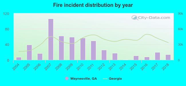 According to the data from the years 2004 - 2018 the average number of fire incidents per year is 33. The highest number of reported fire incidents - 106 took place in 2007, and the least - 1 in 2014. The data has a growing trend.
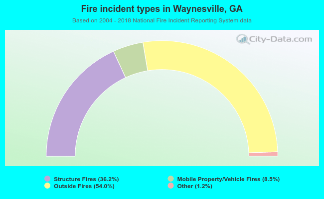 When looking into fire subcategories, the most incidents belonged to: Outside Fires (54.0%), and Structure Fires (36.2%).
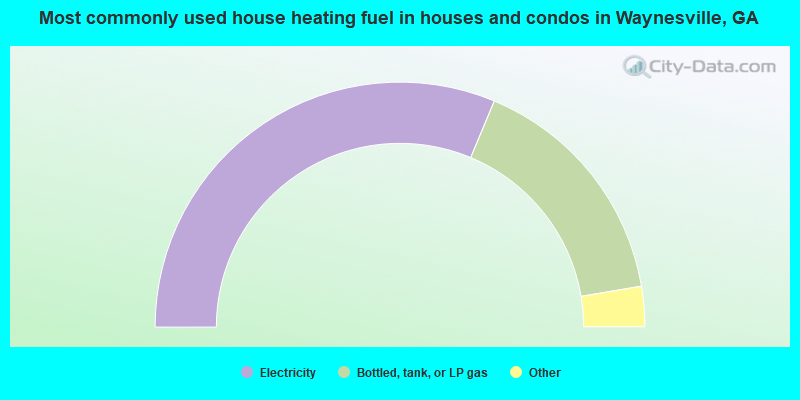
- 62.6%Electricity
- 32.1%Bottled, tank, or LP gas
- 3.5%Wood
- 1.4%Utility gas
- 0.4%Fuel oil, kerosene, etc.
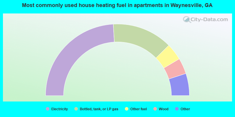
- 48.1%Electricity
- 27.1%Bottled, tank, or LP gas
- 7.6%Other fuel
- 7.1%Wood
- 3.3%Utility gas
- 3.3%Fuel oil, kerosene, etc.
- 3.3%No fuel used
Waynesville compared to Georgia state average:
- Median household income below state average.
- Median house value significantly below state average.
- Unemployed percentage below state average.
- Black race population percentage significantly below state average.
- Hispanic race population percentage significantly below state average.
- Median age below state average.
- Foreign-born population percentage significantly below state average.
- Renting percentage below state average.
- Length of stay since moving in significantly above state average.
- Number of rooms per house significantly below state average.
- House age significantly below state average.
- Number of college students below state average.
- Percentage of population with a bachelor's degree or higher significantly below state average.
Waynesville on our top lists:
- #1 on the list of "Top 101 cities with largest percentage of females in occupations: rail and water transportation workers (population 5,000+)"
- #6 on the list of "Top 101 cities with largest percentage of males in industries: vending machine operators (population 5,000+)"
- #7 on the list of "Top 101 cities with largest percentage of females in occupations: bus drivers (population 5,000+)"
- #7 on the list of "Top 101 cities with largest percentage of males in occupations: pipelayers, plumbers, pipefitters, and steamfitters (population 5,000+)"
- #8 on the list of "Top 101 cities with largest percentage of females in occupations: waiters and waitresses (population 5,000+)"
- #9 on the list of "Top 101 cities with the largest percentage of mobile homes (2,000+ housing units)"
- #10 on the list of "Top 101 cities with largest percentage of females in occupations: painters and paperhangers (population 5,000+)"
- #11 on the list of "Top 101 cities with largest percentage of females in industries: miscellaneous durable goods merchant wholesalers (population 5,000+)"
- #14 on the list of "Top 101 cities with largest percentage of females in occupations: personal appearance workers (population 5,000+)"
- #18 on the list of "Top 101 cities with largest percentage of females in industries: private households (population 5,000+)"
- #25 on the list of "Top 101 cities with the most people carpooling to work (population 5,000+)"
- #36 on the list of "Top 101 cities with largest percentage of males in industries: paper (population 5,000+)"
- #40 on the list of "Top 101 cities with largest percentage of females in industries: personal and laundry services (population 5,000+)"
- #46 on the list of "Top 101 cities with largest percentage of females in industries: groceries and related products merchant wholesalers (population 5,000+)"
- #46 on the list of "Top 101 cities with largest percentage of males in industries: religious, grantmaking, civic, professional, and similar organizations (population 5,000+)"
- #51 on the list of "Top 101 cities with largest percentage of females in industries: pharmacies and drug stores (population 5,000+)"
- #53 on the list of "Top 101 cities with largest percentage of females in industries: department and other general merchandise stores (population 5,000+)"
- #65 on the list of "Top 101 cities with largest percentage of males in industries: machinery (population 5,000+)"
- #69 on the list of "Top 101 cities with the largest percentage of mobile homes (200+ housing units)"
- #72 on the list of "Top 101 cities with largest percentage of males in industries: chemicals (population 5,000+)"
- #79 on the list of "Top 101 counties with the smallest number of people without health insurance coverage in 2000"