West Box Elder, Utah
Submit your own pictures of this place and show them to the world
- OSM Map
- General Map
- Google Map
- MSN Map

| Males: 247 | |
| Females: 223 |
| Median resident age: | 27.3 years |
| Utah median age: | 27.1 years |
Zip code: 84329
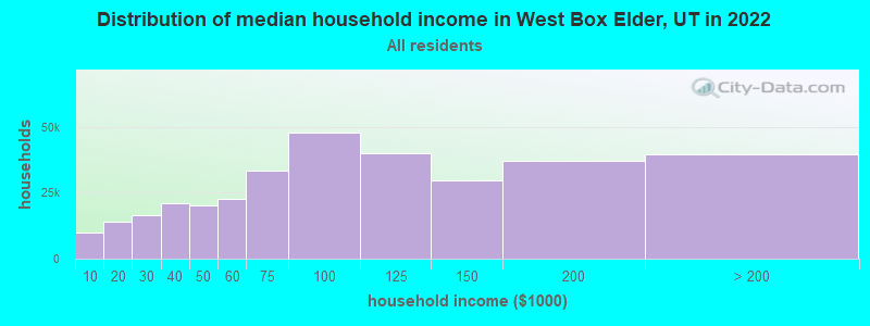
| West Box Elder: | $44,998 |
| UT: | $89,168 |
Estimated per capita income in 2022: $26,504 (it was $12,941 in 2000)
West Box Elder CCD income, earnings, and wages data
Estimated median house or condo value in 2022: $258,975 (it was $80,700 in 2000)
| West Box Elder: | $258,975 |
| UT: | $499,500 |
West Box Elder, UT residents, houses, and apartments details
Detailed information about poverty and poor residents in West Box Elder, UT


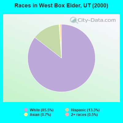
- 36085.5%White alone
- 5613.3%Hispanic
- 30.7%Asian alone
- 20.5%Two or more races
Races in West Box Elder detailed stats: ancestries, foreign born residents, place of birth
 Recent articles from our blog. Our writers, many of them Ph.D. graduates or candidates, create easy-to-read articles on a wide variety of topics.

Current Local Time: MST time zone
Land area: 3798.3 square miles.
Population density: 0.1 people per square mile (very low).
| West Box Elder CCD: | 0.7% ($529) |
| Utah: | 0.7% ($956) |
Nearest city with pop. 50,000+: Ogden, UT  (81.1 miles , pop. 77,226).
Nearest city with pop. 200,000+: Las Vegas, NV (383.2 miles , pop. 478,434).
Nearest city with pop. 1,000,000+: Phoenix, AZ (560.8 miles , pop. 1,321,045).
Nearest cities:
), ), ), )Latitude: 41.56 N, Longitude: 113.46 W

| Here: | 2.3% |
| Utah: | 2.5% |
Average climate in West Box Elder, Utah
Based on data reported by over 4,000 weather stations


Earthquake activity:
West Box Elder-area historical earthquake activity is significantly above Utah state average. It is 2353% greater than the overall U.S. average.On 10/3/1915 at 06:52:48, a magnitude 7.6 (7.6 UK, Class: Major, Intensity: VIII - XII) earthquake occurred 223.3 miles away from the city center
On 8/18/1959 at 06:37:13, a magnitude 7.7 (7.7 UK) earthquake occurred 251.4 miles away from the city center, causing $26,000,000 total damage
On 10/28/1983 at 14:06:06, a magnitude 7.3 (6.2 MB, 7.3 MS, 7.0 MW) earthquake occurred 174.8 miles away from West Box Elder center, causing 2 deaths (2 shaking deaths) and 3 injuries, causing $15,000,000 total damage
On 3/28/1975 at 02:31:05, a magnitude 6.2 (6.1 MB, 6.0 MS, 6.2 ML, Class: Strong, Intensity: VII - IX) earthquake occurred 59.5 miles away from the city center
On 12/21/1932 at 06:10:09, a magnitude 7.2 (7.2 UK) earthquake occurred 323.3 miles away from West Box Elder center
On 12/16/1954 at 11:07:12, a magnitude 7.0 (7.0 UK) earthquake occurred 289.7 miles away from the city center
Magnitude types: body-wave magnitude (MB), local magnitude (ML), surface-wave magnitude (MS), moment magnitude (MW)
Natural disasters:
The number of natural disasters in Box Elder County (8) is smaller than the US average (15).Major Disasters (Presidential) Declared: 4
Emergencies Declared: 2
Causes of natural disasters: Floods: 5, Landslides: 3, Storms: 2, Drought: 1, Hurricane: 1, Mudslide: 1, Winter Storm: 1, Other: 1 (Note: some incidents may be assigned to more than one category).
Colleges/universities with over 2000 students nearest to West Box Elder:
- Weber State University (about 83 miles; Ogden, UT; Full-time enrollment: 17,655)
- Utah State University (about 86 miles; Logan, UT; FT enrollment: 21,131)
- College of Southern Idaho (about 88 miles; Twin Falls, ID; FT enrollment: 5,051)
- Latter-day Saints Business College (about 98 miles; Salt Lake City, UT; FT enrollment: 2,059)
- Salt Lake Community College (about 101 miles; Salt Lake City, UT; FT enrollment: 20,797)
- University of Utah (about 101 miles; Salt Lake City, UT; FT enrollment: 28,454)
- Westminster College (about 102 miles; Salt Lake City, UT; FT enrollment: 2,870)
Points of interest:
Notable locations in West Box Elder: Clear Creek Campground (A), Clear Creek (B), Bovine (C), C-Bar Ranch (D), Hershey Ranch (E), Kimber Ranch (F), James Brothers Ranch (G), Old Stage Station (H), Lambert Ranch (I), Clear Creek Campground (J), Watercress (K), The Tenmile Place (L), Morris Ranch (M), Dipping Vat (N), Palmer Ranch (O), Morris Ranch (P), Bar F Ranch (Q), Kunzlers Ranch (R), Onemile Guard Station (S), Oasis (T). Display/hide their locations on the map
Church in West Box Elder: The Church of Jesus Christ of Latter Day Saints (A). Display/hide its location on the map
Cemeteries: Yost Cemetery (1), Kelton Cemetery (2), Terrace Cemetery (3), Park Valley Cemetery (4), Lynn Cemetery (5), Grouse Creek Cemetery (6), Clear Creek Cemetery (7). Display/hide their locations on the map
Lakes and reservoirs: Fisher Lake (A), Gunnison Bay (B), Warm Spring Reservoir (C), Lynn Reservoir (D), East Lake (E), Trail Pass Reservoir (F), Baker Hills Reservoir (G), Muddy Creek Reservoir (H). Display/hide their locations on the map
Streams, rivers, and creeks: South Fork George Creek (A), South Fork Hardesty Creek (B), South Fork Johnson Creek (C), Indian Creek (D), Sparks Slough (E), Hubbard Creek (F), Big Pole Creek (G), Spring Creek (H), Mahogany Creek (I). Display/hide their locations on the map
Parks in West Box Elder include: Gunnison Island State Wildlife Management Area (1), Hat Island Wildlife Refuge (2), Locomotive Springs Waterfowl Management Area (3), Hat Island State Wildlife Management Area (4). Display/hide their locations on the map
| This place: | 3.0 people |
| Utah: | 3.1 people |
| This place: | 73.6% |
| Whole state: | 75.2% |
| This place: | 2.4% |
| Whole state: | 4.6% |
No gay or lesbian households reported
| This place: | 10.4% |
| Whole state: | 9.4% |
| This place: | 10.4% |
| Whole state: | 3.9% |
For population 15 years and over in West Box Elder:
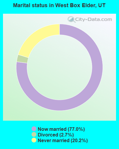
- Never married: 20.2%
- Now married: 77.0%
- Separated: 0.0%
- Widowed: 0.0%
- Divorced: 2.7%
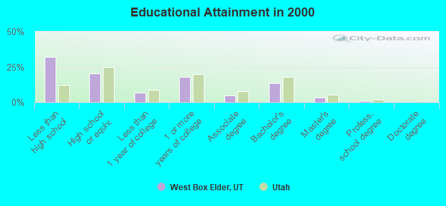
For population 25 years and over in West Box Elder:
- High school or higher: 67.9%
- Bachelor's degree or higher: 17.7%
- Graduate or professional degree: 4.2%
- Unemployed: 2.4%
- Mean travel time to work (commute): 19.5 minutes
| Here: | 14.1 |
| Utah average: | 10.5 |
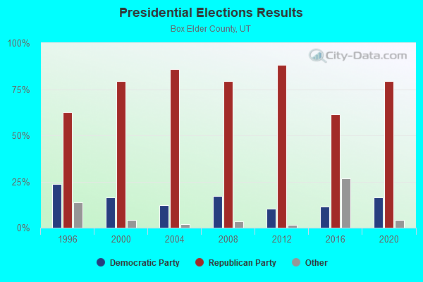
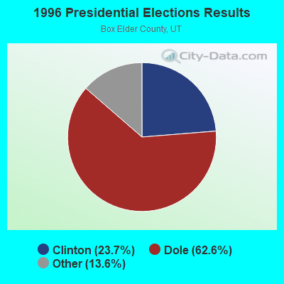
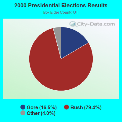
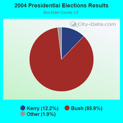
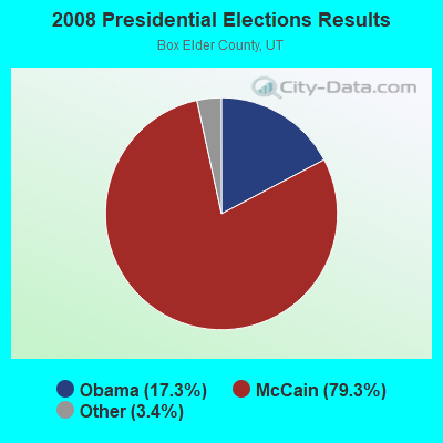
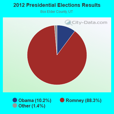
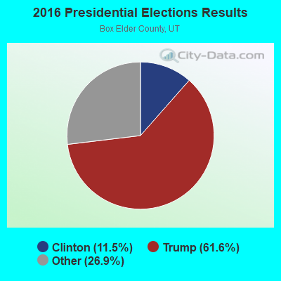

Graphs represent county-level data. Detailed 2008 Election Results
Religion statistics for West Box Elder, UT (based on Box Elder County data)
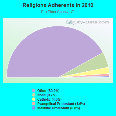
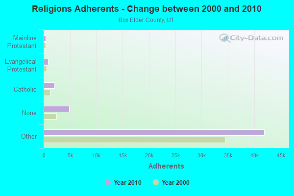
| Religion | Adherents | Congregations |
|---|---|---|
| Other | 41,921 | 105 |
| Catholic | 2,008 | 2 |
| Evangelical Protestant | 807 | 10 |
| Mainline Protestant | 389 | 3 |
| None | 4,850 | - |
Food Environment Statistics:
| This county: | 0.84 / 10,000 pop. |
| Utah: | 1.37 / 10,000 pop. |
| Box Elder County: | 0.21 / 10,000 pop. |
| Utah: | 0.18 / 10,000 pop. |
| Box Elder County: | 0.42 / 10,000 pop. |
| Utah: | 0.41 / 10,000 pop. |
| This county: | 3.14 / 10,000 pop. |
| Utah: | 2.82 / 10,000 pop. |
| Here: | 3.14 / 10,000 pop. |
| State: | 5.09 / 10,000 pop. |
| Box Elder County: | 6.1% |
| Utah: | 6.3% |
| Here: | 27.6% |
| Utah: | 23.6% |
Strongest AM radio stations in West Box Elder:
- KALL (700 AM; 50 kW; NORTH SALT LAKE CITY, UT; Owner: CITICASTERS LICENSES, L.P.)
- KIQN (1010 AM; 50 kW; TOOELE, UT)
- KSL (1160 AM; 50 kW; SALT LAKE CITY, UT; Owner: BONNEVILLE HOLDING COMPANY)
- KSOS (800 AM; 10 kW; BRIGHAM CITY, UT; Owner: SIMMONS-SLC, LS, LLC)
- KBOI (670 AM; 50 kW; BOISE, ID; Owner: CITADEL BROADCASTING COMPANY)
- KTKK (630 AM; 10 kW; SANDY, UT; Owner: UNITED BROADCASTING COMPANY)
- KANN (1120 AM; 10 kW; ROY, UT; Owner: FAITH COMMUNICATIONS CORPORATION)
- KVNU (610 AM; 5 kW; LOGAN, UT; Owner: SUN VALLEY RADIO,INC.)
- KBEE (860 AM; 10 kW; SALT LAKE CITY, UT; Owner: CITADEL BROADCASTING COMPANY)
- KXOL (1660 AM; 10 kW; BRIGHAM CITY, UT; Owner: SIMMONS-SLC, LS, LLC)
- KLO (1430 AM; 10 kW; OGDEN, UT; Owner: KLO BROADCASTING CO.)
- KKDS (1060 AM; 10 kW; SOUTH SALT LAKE, UT; Owner: HOLIDAY BROADCASTING COMPANY)
- KNRS (570 AM; 5 kW; SALT LAKE CITY, UT; Owner: CITICASTERS LICENSES, L.P.)
Strongest FM radio stations in West Box Elder:
- KCIR (90.7 FM; TWIN FALLS, ID; Owner: FAITH COMMUNICATIONS CORP)
- KKMV (92.5 FM; RUPERT, ID; Owner: TRI-MARKET RADIO BROADCASTERS, INC.)
- KZDX (99.9 FM; BURLEY, ID; Owner: KART & EAGLE ROCK B/C INC,TENANTS)
- KUUU (92.1 FM; TOOELE, UT; Owner: MILLCREEK BROADCASTING, L.L.C.)
- KUDD (107.9 FM; ROY, UT; Owner: MILLCREEK BROADCASTING, L.L.C.)
- KBSY (88.5 FM; BURLEY, ID; Owner: IDAHO STATE BOARD OF EDUCATION)
- KRAR (106.9 FM; BRIGHAM CITY, UT; Owner: MERCURY BROADCASTING COMPANY, INC.)
- KYFO-FM (95.5 FM; OGDEN, UT; Owner: BIBLE BROADCASTING NETWORK, INC.)
- KJQN (100.7 FM; BRIGHAM CITY, UT; Owner: SIMMONS-SLC, LS, LLC)
TV broadcast stations around West Box Elder:
- K59BV (Channel 59; LAVA HOT SPRINGS, ID; Owner: STATE BOARD OF EDUCATION (IEPBS))
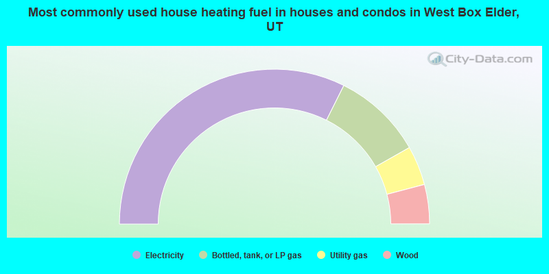
- 64.7%Electricity
- 18.8%Bottled, tank, or LP gas
- 8.2%Utility gas
- 8.2%Wood
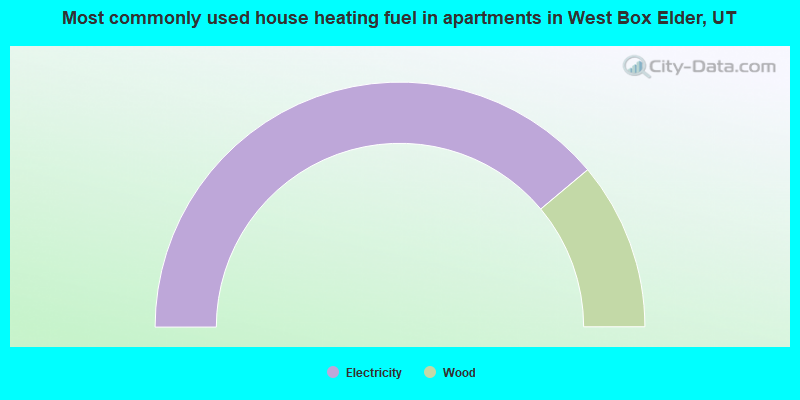
- 77.8%Electricity
- 22.2%Wood
West Box Elder compared to Utah state average:
- Median household income below state average.
- Median house value below state average.
- Unemployed percentage significantly below state average.
- Black race population percentage significantly below state average.
- Foreign-born population percentage significantly below state average.
- Length of stay since moving in significantly above state average.
- Number of rooms per house significantly below state average.
- House age significantly below state average.
- Number of college students below state average.
West Box Elder on our top lists:
- #15 on the list of "Top 100 cities with largest land areas"
- #8 on the list of "Top 101 counties with the highest Ozone (1-hour) air pollution readings in 2012 (ppm)"
- #35 on the list of "Top 101 counties with highest percentage of residents voting for Romney (Republican) in the 2012 Presidential Election"
- #55 on the list of "Top 101 counties with the most Other congregations"
- #61 on the list of "Top 101 counties with the most Other adherents"
- #90 on the list of "Top 101 counties with the lowest Particulate Matter (PM2.5) Annual air pollution readings in 2012 (µg/m3)"