Western Shoshone, Idaho
Submit your own pictures of this place and show them to the world
- OSM Map
- General Map
- Google Map
- MSN Map

| Males: 131 | |
| Females: 122 |
| Median resident age: | 26.6 years |
| Idaho median age: | 33.2 years |
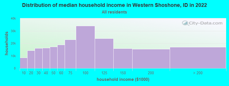
| Western Shoshone: | $49,434 |
| ID: | $72,785 |
Estimated per capita income in 2022: $18,402 (it was $9,536 in 2000)
Western Shoshone CCD income, earnings, and wages data
Estimated median house or condo value in 2022: $221,542 (it was $57,100 in 2000)
| Western Shoshone: | $221,542 |
| ID: | $432,500 |
Western Shoshone, ID residents, houses, and apartments details
Detailed information about poverty and poor residents in Western Shoshone, ID
Compare current foreclosures near your location:
| Photo | Address | Area | Beds / Baths | Price | Details |
|---|---|---|---|---|---|

|
#1
N Rhodes St
Pretty Prairie, KS 67570
|
1,725 sq. feet
|
2 baths 4 beds |
show details | |

|
#2
S Goddard Rd
Goddard, KS 67052
|
1,054 sq. feet
|
2 baths 2 beds |
show details | |

|
#3
W 21st St N
Cheney, KS 67025
|
3,190 sq. feet
|
3 baths 5 beds |
show details | |

|
#4
E Winterset St
Goddard, KS 67052
|
816 sq. feet
|
1 baths 2 beds |
show details | |

|
#5
NE Waterloo Ave
Murdock, KS 67111
|
1,220 sq. feet
|
1 baths 3 beds |
show details | |

|
#6
W 39th St S
Goddard, KS 67052
|
4,221 sq. feet
|
3 baths 3 beds |
show details | |

|
#7
E Arlington Rd
Haven, KS 67543
|
960 sq. feet
|
1 baths 2 beds |
show details | |

|
#8
S 391st St W
Cheney, KS 67025
|
2,558 sq. feet
|
3 baths 3 beds |
show details | |

|
#9
SE Viney Ave
Murdock, KS 67111
|
- sq. feet
|
- baths - beds |
show details | |

|
#10
W Main St
Mount Hope, KS 67108
|
- sq. feet
|
- baths - beds |
show details |
| Photo | Address | Area | Beds / Baths | Price | Details |
|---|---|---|---|---|---|

|
#11
N 189th Cir W
Colwich, KS 67030
|
- sq. feet
|
- baths - beds |
show details | |

|
#12
N Main St
Goddard, KS 67052
|
- sq. feet
|
- baths - beds |
show details | |

|
#13
Martens Ct
Goddard, KS 67052
|
- sq. feet
|
- baths - beds |
show details | |

|
#14
E 4th Ave Apt 1
Cheney, KS 67025
|
- sq. feet
|
- baths - beds |
show details | |

|
#15
W Maple St Lot D
Goddard, KS 67052
|
- sq. feet
|
- baths - beds |
show details | |

|
#16
W 47th St S
Garden Plain, KS 67050
|
- sq. feet
|
- baths - beds |
show details | |

|
#17
S 339th St W
Cheney, KS 67025
|
- sq. feet
|
- baths - beds |
show details | |

|
#18
E Casey Dr
Goddard, KS 67052
|
- sq. feet
|
- baths - beds |
show details | |

|
Check over 1 million property listings on Foreclosure.com!
|
browse all offers | |||

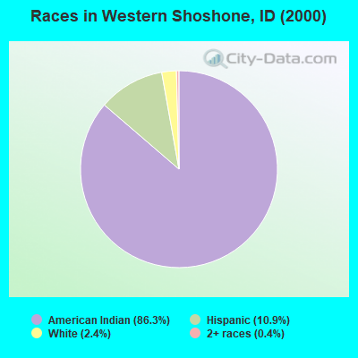
- 21486.3%American Indian alone
- 2710.9%Hispanic
- 62.4%White alone
- 10.4%Two or more races
Races in Western Shoshone detailed stats: ancestries, foreign born residents, place of birth
 Recent articles from our blog. Our writers, many of them Ph.D. graduates or candidates, create easy-to-read articles on a wide variety of topics.

Current Local Time: MST time zone
Land area: 226.1 square miles.
Population density: 1.1 people per square mile (very low).

| Western Shoshone CCD: | 1.2% ($667) |
| Idaho: | 1.0% ($1,007) |
Nearest city with pop. 50,000+: Nampa, ID  (107.3 miles , pop. 51,867).
Nearest city with pop. 200,000+: Sacramento, CA (369.9 miles , pop. 407,018).
Nearest city with pop. 1,000,000+: Los Angeles, CA (564.0 miles , pop. 3,694,820).
Nearest cities:
), ), Latitude: 42.05 N, Longitude: 116.16 W
Area code commonly used in this area: 775

| Here: | 4.3% |
| Idaho: | 3.1% |
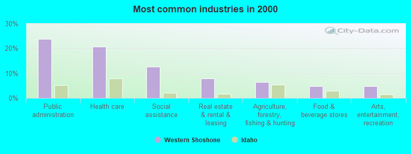
- Public administration (23.8%)
- Health care (20.6%)
- Social assistance (12.7%)
- Real estate & rental & leasing (7.9%)
- Agriculture, forestry, fishing & hunting (6.3%)
- Food & beverage stores (4.8%)
- Arts, entertainment, recreation (4.8%)
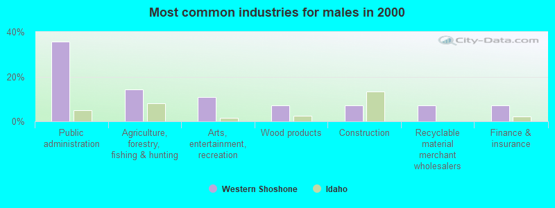
- Public administration (35.7%)
- Agriculture, forestry, fishing & hunting (14.3%)
- Arts, entertainment, recreation (10.7%)
- Wood products (7.1%)
- Construction (7.1%)
- Recyclable material merchant wholesalers (7.1%)
- Finance & insurance (7.1%)
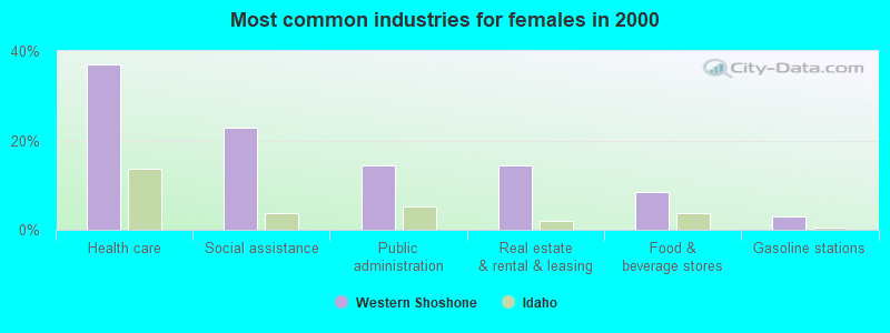
- Health care (37.1%)
- Social assistance (22.9%)
- Public administration (14.3%)
- Real estate & rental & leasing (14.3%)
- Food & beverage stores (8.6%)
- Gasoline stations (2.9%)
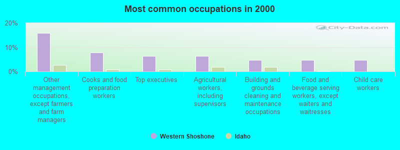
- Other management occupations, except farmers and farm managers (15.9%)
- Cooks and food preparation workers (7.9%)
- Top executives (6.3%)
- Agricultural workers, including supervisors (6.3%)
- Building and grounds cleaning and maintenance occupations (4.8%)
- Food and beverage serving workers, except waiters and waitresses (4.8%)
- Child care workers (4.8%)
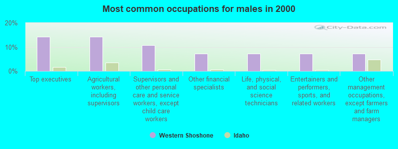
- Top executives (14.3%)
- Agricultural workers, including supervisors (14.3%)
- Supervisors and other personal care and service workers, except child care workers (10.7%)
- Other financial specialists (7.1%)
- Life, physical, and social science technicians (7.1%)
- Entertainers and performers, sports, and related workers (7.1%)
- Other management occupations, except farmers and farm managers (7.1%)
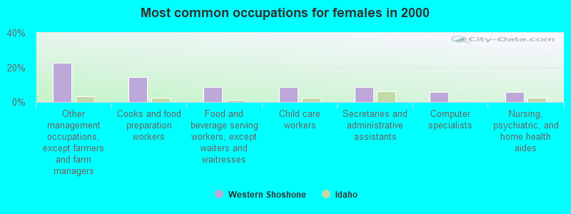
- Other management occupations, except farmers and farm managers (22.9%)
- Cooks and food preparation workers (14.3%)
- Food and beverage serving workers, except waiters and waitresses (8.6%)
- Child care workers (8.6%)
- Secretaries and administrative assistants (8.6%)
- Computer specialists (5.7%)
- Nursing, psychiatric, and home health aides (5.7%)
Average climate in Western Shoshone, Idaho
Based on data reported by over 4,000 weather stations


Earthquake activity:
Western Shoshone-area historical earthquake activity is significantly above Idaho state average. It is 2846% greater than the overall U.S. average.On 10/3/1915 at 06:52:48, a magnitude 7.6 (7.6 UK, Class: Major, Intensity: VIII - XII) earthquake occurred 128.0 miles away from Western Shoshone center
On 10/28/1983 at 14:06:06, a magnitude 7.3 (6.2 MB, 7.3 MS, 7.0 MW) earthquake occurred 183.9 miles away from the city center, causing 2 deaths (2 shaking deaths) and 3 injuries, causing $15,000,000 total damage
On 8/18/1959 at 06:37:13, a magnitude 7.7 (7.7 UK) earthquake occurred 327.0 miles away from the city center, causing $26,000,000 total damage
On 12/16/1954 at 11:07:12, a magnitude 7.0 (7.0 UK) earthquake occurred 219.6 miles away from the city center
On 12/21/1932 at 06:10:09, a magnitude 7.2 (7.2 UK) earthquake occurred 265.2 miles away from the city center
On 8/24/1954 at 05:51:30, a magnitude 6.8 (6.8 UK, Class: Strong, Intensity: VII - IX) earthquake occurred 209.1 miles away from the city center
Magnitude types: body-wave magnitude (MB), surface-wave magnitude (MS), moment magnitude (MW)
Natural disasters:
The number of natural disasters in Owyhee County (5) is a lot smaller than the US average (15).Major Disasters (Presidential) Declared: 3
Emergencies Declared: 1
Causes of natural disasters: Floods: 3, Storms: 2, Heavy Rain: 1, Hurricane: 1, Other: 1 (Note: some incidents may be assigned to more than one category).
Colleges/universities with over 2000 students nearest to Western Shoshone:
- College of Southern Idaho (about 94 miles; Twin Falls, ID; Full-time enrollment: 5,051)
- Northwest Nazarene University (about 107 miles; Nampa, ID; FT enrollment: 2,290)
- Boise State University (about 108 miles; Boise, ID; FT enrollment: 16,774)
- College of Western Idaho (about 110 miles; Nampa, ID; FT enrollment: 6,300)
- Treasure Valley Community College (about 143 miles; Ontario, OR; FT enrollment: 2,055)
- Idaho State University (about 199 miles; Pocatello, ID; FT enrollment: 10,350)
- Utah State University (about 225 miles; Logan, UT; FT enrollment: 21,131)
Points of interest:
Notable locations in Western Shoshone: Stone Corral (A), Red Cabin (B), Dell Dick Windmill (C), Windmill Number 3 (D), Windmill Number 2 (E), Windmill Number 1 (F). Display/hide their locations on the map
Cemetery: Miller Creek Cemetery (1). Display/hide its location on the map
Lakes, reservoirs, and swamps: Dry Lake (A), Harris Lake (B), Little Jarvis Lake (C), Ross Lake (D), Rough Lake (E), Mountain View Lake (F), Lower Antelope Reservoir (G), Upper Antelope Reservoir (H). Display/hide their locations on the map
Streams, rivers, and creeks: Bell Creek (A), Billy Shaw Slough (B), Blue Creek (C), Boyle Creek (D), Damon Trail Creek (E), Dry Creek (F), Meadow Creek (G), Miller Creek (H), Mud Creek (I). Display/hide their locations on the map
| This place: | 3.1 people |
| Idaho: | 2.7 people |
| This place: | 45.0% |
| Whole state: | 71.9% |
| This place: | 13.8% |
| Whole state: | 4.8% |
Likely homosexual households (counted as self-reported same-sex unmarried-partner households)
- Lesbian couples: 2.5% of all households
- Gay men: 1.2% of all households
| This place: | 30.2% |
| Whole state: | 11.8% |
| This place: | 20.3% |
| Whole state: | 4.6% |
For population 15 years and over in Western Shoshone:
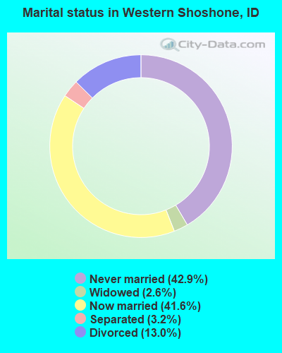
- Never married: 42.9%
- Now married: 41.6%
- Separated: 3.2%
- Widowed: 2.6%
- Divorced: 13.0%
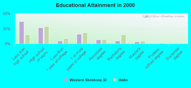
For population 25 years and over in Western Shoshone:
- High school or higher: 63.0%
- Bachelor's degree or higher: 8.4%
- Graduate or professional degree: 3.4%
- Unemployed: 27.6%
- Mean travel time to work (commute): 12.4 minutes

| Here: | 9.4 |
| Idaho average: | 11.1 |
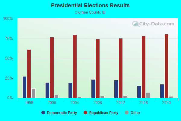

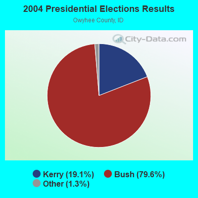
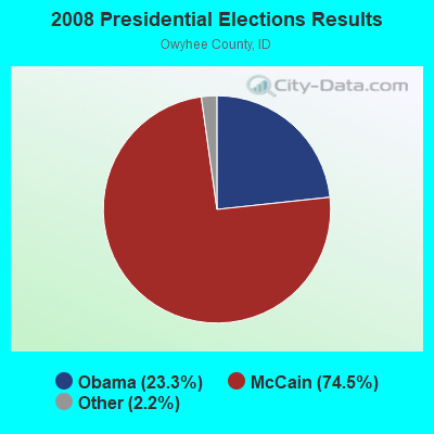
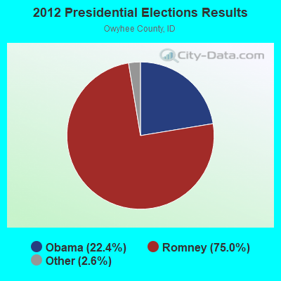
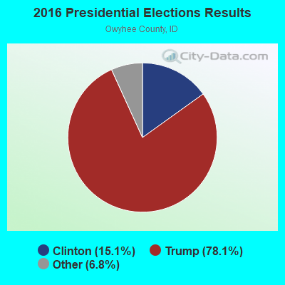
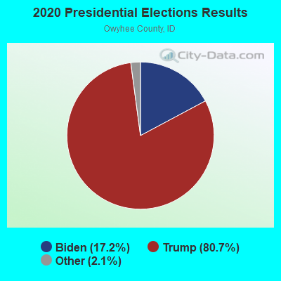
Graphs represent county-level data. Detailed 2008 Election Results
Religion statistics for Western Shoshone, ID (based on Owyhee County data)
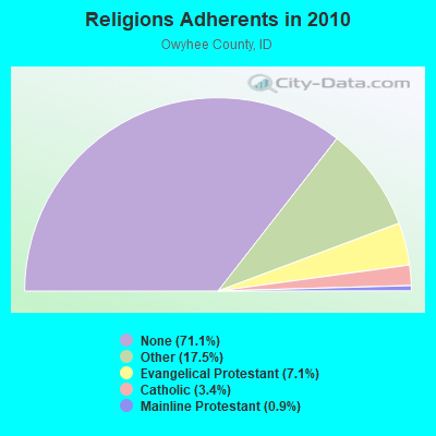

| Religion | Adherents | Congregations |
|---|---|---|
| Other | 2,014 | 5 |
| Evangelical Protestant | 813 | 12 |
| Catholic | 396 | 6 |
| Mainline Protestant | 108 | 2 |
| None | 8,195 | - |
Food Environment Statistics:
| Here: | 3.72 / 10,000 pop. |
| Idaho: | 1.88 / 10,000 pop. |
| Here: | 3.72 / 10,000 pop. |
| State: | 3.87 / 10,000 pop. |
| This county: | 7.43 / 10,000 pop. |
| Idaho: | 7.75 / 10,000 pop. |
| Here: | 7.0% |
| State: | 7.7% |
| Here: | 27.2% |
| Idaho: | 25.7% |
| This county: | 17.6% |
| Idaho: | 11.7% |
Strongest AM radio stations in Western Shoshone:
- KBOI (670 AM; 50 kW; BOISE, ID; Owner: CITADEL BROADCASTING COMPANY)
- KBSU (730 AM; 15 kW; BOISE, ID; Owner: IDAHO STATE BOARD OF EDUCATION)
- KWEI (1260 AM; 50 kW; WEISER, ID; Owner: TREASURE VALLEY BROADCASTING CO.)
- KALL (700 AM; 50 kW; NORTH SALT LAKE CITY, UT; Owner: CITICASTERS LICENSES, L.P.)
- KKOH (780 AM; 50 kW; RENO, NV; Owner: CITADEL BROADCASTING COMPANY)
- KIQN (1010 AM; 50 kW; TOOELE, UT)
- KSL (1160 AM; 50 kW; SALT LAKE CITY, UT; Owner: BONNEVILLE HOLDING COMPANY)
- KGEM (1140 AM; 10 kW; BOISE, ID; Owner: JOURNAL BROADCAST CORPORATION)
- KIDO (580 AM; 5 kW; NAMPA, ID; Owner: CITICASTERS LICENSES, L.P.)
- KFXD (630 AM; 5 kW; BOISE, ID; Owner: CITICASTERS LICENSES, L.P.)
- KBGN (1060 AM; daytime; 10 kW; CALDWELL, ID; Owner: NELSON M. AND KAREN E. WILSON)
- KTFI (1270 AM; 5 kW; TWIN FALLS, ID; Owner: AGM-IDAHO BROADCASTING, LLC)
- KPOJ (620 AM; 50 kW; PORTLAND, OR; Owner: CITICASTERS LICENSES, L.P.)
TV broadcast stations around Western Shoshone:
- K05JU (Channel 5; ELKO, NV; Owner: ELKO TELEVISION DISTRICT)
- National Bridge Inventory (NBI) Statistics
- 7Number of bridges
- 43ft / 12.5mTotal length
- $1,050,000Total costs
- 2,310Total average daily traffic
- 201Total average daily truck traffic
- 3,465Total future (year 2039) average daily traffic
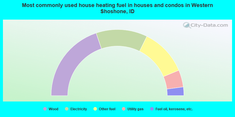
- 39.6%Wood
- 25.0%Electricity
- 22.9%Other fuel
- 8.3%Utility gas
- 4.2%Fuel oil, kerosene, etc.
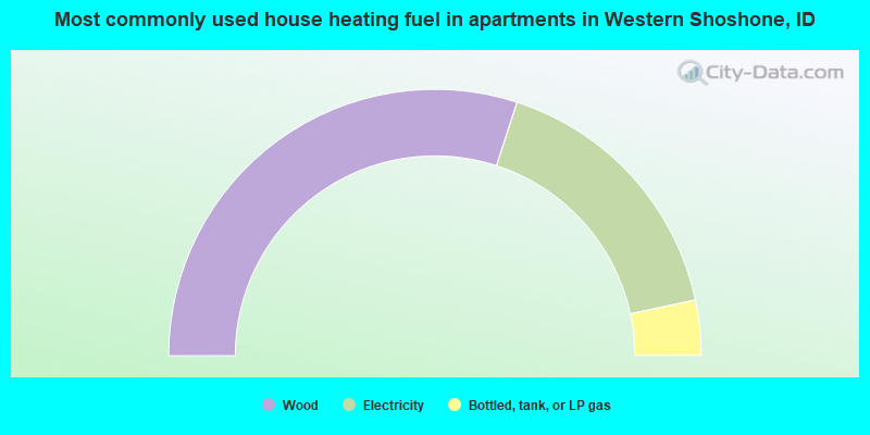
- 60.0%Wood
- 33.3%Electricity
- 6.7%Bottled, tank, or LP gas
Western Shoshone compared to Idaho state average:
- Median house value below state average.
- Unemployed percentage above state average.
- Black race population percentage significantly below state average.
- Median age significantly below state average.
- Foreign-born population percentage significantly below state average.
- Renting percentage significantly below state average.
- Length of stay since moving in significantly above state average.
- Number of rooms per house significantly below state average.
- House age significantly below state average.
- Number of college students significantly below state average.
- Percentage of population with a bachelor's degree or higher significantly below state average.