Welcome to City-Data.com Forum!
U.S. CitiesCity-Data Forum Index
Go Back   City-Data Forum > U.S. Forums > Connecticut
 [Register]
Please register to participate in our discussions with 2 million other members - it's free and quick! Some forums can only be seen by registered members. After you create your account, you'll be able to customize options and access all our 15,000 new posts/day with fewer ads.
View detailed profile (Advanced) or search
site with Google Custom Search

Search Forums  (Advanced)
Closed Thread Start New Thread
 
Old 03-21-2011, 05:52 PM
 
Location: Near the Coast SWCT
83,527 posts, read 75,355,132 times
Reputation: 16626

Advertisements

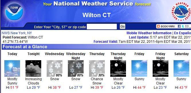
North of Merrit in Connecticut could see close to half foot of snow. Wednesday Night into Thursday.

Thursday morning commute could be messy. Details still being watched but keep your eyes on your local forecasts.

This is from NWS(national weather service) Coast implys Westchester County Coast. CMA = County Warning Area which is Fairfield/Westchester in this message.

National Weather Service Text Product Display

SFC LOW QUICKLY MOVES FROM THE OHIO RIVER VALLEY TO JUST OFF THE MID
ATLANTIC COAST FROM WED MORNING THROUGH THURSDAY MORNING.

IT IS AT THIS TIME THAT WE SHOULD OBSERVE WINTRY PRECIP...WITH
BORDERLINE TEMPS ALOFT AND AT THE SFC. AMPLE LIFT...AND CHILLY AIR
IN PLACE WILL MAKE FOR AN INTERESTING YET CHALLENGING FORECAST.

IN SPITE OF THE LATE MARCH DATE...LATEST RUN OF THE NAM/WRF WOULD
SUPPORT SNOW ACROSS MUCH IF NOT ALL OF THE CWA. HIGHEST CONFIDENCE
IN ACCUMULATING SNOWFALL WOULD BE ACROSS THE INTERIOR...MAINLY SRN
CT AND THE LOWER HUDSON VALLEY. AT THIS TIME...I CANNOT RULE OUT
WARNING LEVEL SNOWFALL FOR AT LEAST SOME PORTION OF THE CWA AS THE
LOW PASSES SOUTH. ADVISORY SNOWS FURTHER SOUTH...BUT MUCH LESS
LIKELY NEAR THE COAST. GFS WEAKER...WARMER AND QUICKER WITH
OVERALL SYSTEM...KEEPING AMOUNTS DOWN.

WARMER SFC TEMPS ON TUESDAY AND INTO TUESDAY NIGHT MAY PREVENT
SNOW FROM STICKING AT THE ONSET...ESPECIALLY NEAR THE COAST.

TEMPS RISE LITTLE IN CLOUDS AND PRECIP WEDNESDAY...WITH READINGS
LIKELY TO HOLD IN THE 30S.

BY WED NIGHT AND THURSDAY...TEMPS ALOFT COOL FURTHER...SO ANY
LINGERING PRECIP WOULD BE IN THE FORM OF SNOW AT THAT TIME.

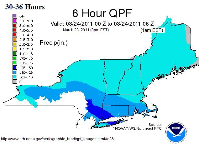
WHEN ALL IS SAID AND DONE THURSDAY...COULD SEE UP TO 6 INCHES OF
SNOW ACROSS PORTIONS OF THE INTERIOR. 1 TO 4 INCHES POSSIBLE AS
YOU HEAD CLOSER TO THE COAST...WITH LITTLE OR NO SNOW ACCUM NEAR
THE COAST...NYC METRO.

 
Old 03-21-2011, 05:54 PM
 
Location: Near the Coast SWCT
83,527 posts, read 75,355,132 times
Reputation: 16626
This is the total snow forecast Graphic which will refresh and change as they update it...

Im thinking Northern Fairfield, New Haven, Middlesex and Litchfield, Hartford, Tolland could see the most accumulations. please keep an eye on this storm and be careful. Merrit southwards could see 1-4"..

 
Old 03-21-2011, 07:05 PM
 
Location: Central Connecticut
576 posts, read 1,219,379 times
Reputation: 205
I hope this failed. Mother Nature please dont let this happened.
 
Old 03-22-2011, 04:50 AM
 
Location: Near the Coast SWCT
83,527 posts, read 75,355,132 times
Reputation: 16626
Be Careful if your driving West.. Parts of New Jersey & PA will see over a foot. Don't forget, post your observations and thoughts during the storm here. Thanks!

 
Old 03-22-2011, 05:05 AM
 
Location: Near the Coast SWCT
83,527 posts, read 75,355,132 times
Reputation: 16626
Here's the forecast for Wilton... Keep in mind...surface temps should hover 35 but the air 7000 feet above us will be below freezing so that means the snow will not get a chance to melt on the way down.

At first the snow wont stick but after a few minutes it could get hazardous as we saw Monday with just 2 inches falling there were many accidents even though it wasn't sticking on the road, it got slushy. That was just 2 inches. This could be plowable snows.

Starts during Wednesday Evening commute and ends Thursday morning

 
Old 03-22-2011, 01:27 PM
 
Location: Near the Coast SWCT
83,527 posts, read 75,355,132 times
Reputation: 16626
Times and precip amounts are being tweaked with each model run... Looks like we'll be ok for Thursday morning but Wednesday's evening commute could get messy..(not disasterous)..even slush makes for slippery conditions.

This is the total "liquid" precip to fall... Looks like SE NY(northern Westchester) and SW CT (northern Fairfield / Southern Litchfield) is getting the bulk of this... at 10:1 snow ratios .25-.50" of liquid is 3-6". Keep in mind...this is just a 6hr forecast...its snowing before and after this lightly.

This is from NOAA..link embedded in pic.

Northern NJ has a Winter Storm Warning out already. Those commuting need consider planning ahead.

 
Old 03-22-2011, 01:55 PM
 
Location: Out in the stix
1,607 posts, read 3,091,635 times
Reputation: 1030
should melt pretty quickly whatever we get, a few inches not a big deal this time of year, we've had it pretty easy this March so far, all mostly pure rain events, and even yesterday's snow here in Glastonbury didn't stick at all. Bring on Spring, I've had enough.
 
Old 03-22-2011, 04:48 PM
 
Location: Near the Coast SWCT
83,527 posts, read 75,355,132 times
Reputation: 16626
Winter Storm Watch Up already for Northern & Southern Litchfield. Possible whiteout conditions during heavy snow...

National Weather Service Forecast Office - Taunton, MA - for Litchfield County

...WINTER STORM WATCH IN EFFECT FROM WEDNESDAY AFTERNOON THROUGH
THURSDAY MORNING...

THE NATIONAL WEATHER SERVICE IN ALBANY HAS ISSUED A WINTER STORM
WATCH FOR SNOW...WHICH IS IN EFFECT FROM WEDNESDAY AFTERNOON THROUGH
THURSDAY MORNING.

* LOCATIONS...THE MID HUDSON VALLEY AND LITCHFIELD COUNTY.

* HAZARD TYPES...SNOW.

* ACCUMULATIONS...4 TO 9 INCHES.

* TIMING...BEGINNING TOMORROW MORNING...BECOMING STEADIER AND
HEAVIER TOMORROW AFTERNOON AND NIGHT. ENDING THURSDAY MORNING.

* IMPACTS...HAZARDOUS TRAVEL CONDITIONS WITH SNOW COVERED ROADS.
HEAVY WET SNOW MAY CAUSE SOME ISOLATED DOWNED TREE LIMBS AND
POWER LINES WITH ISOLATED POWER OUTAGES POSSIBLE.

* TEMPERATURES...IN THE 30S DURING THE DAY...AND UPPER 20S TO
AROUND 30 AT NIGHT.

* VISIBILITIES...BELOW 1 MILE DURING THE HEAVIEST SNOW.

PRECAUTIONARY/PREPAREDNESS ACTIONS...

A WINTER STORM WATCH MEANS THERE IS A POTENTIAL FOR SIGNIFICANT
SNOW...SLEET...OR ICE ACCUMULATIONS THAT MAY IMPACT TRAVEL.
CONTINUE TO MONITOR THE LATEST FORECASTS.
 
Old 03-23-2011, 09:39 AM
 
105 posts, read 203,023 times
Reputation: 189
Totally excited about the LAST snow of this winter.
 
Old 03-23-2011, 09:46 AM
 
Location: Live in NY, work in CT
11,299 posts, read 18,895,695 times
Reputation: 5126
Interesting side note, both my wife and I are working in Stamford today, me downtown right near the Sound, her up a little north of the Merritt. Here it never "stuck" (looks like it rained outside), but she said to me at 7:45am when she arrived at work it was starting to stick to cars and grass. That's just a few miles apart, amazing contrast!
Please register to post and access all features of our very popular forum. It is free and quick. Over $68,000 in prizes has already been given out to active posters on our forum. Additional giveaways are planned.

Detailed information about all U.S. cities, counties, and zip codes on our site: City-data.com.


Closed Thread


Over $104,000 in prizes was already given out to active posters on our forum and additional giveaways are planned!

Go Back   City-Data Forum > U.S. Forums > Connecticut
Similar Threads

All times are GMT -6. The time now is 02:44 AM.

© 2005-2024, Advameg, Inc. · Please obey Forum Rules · Terms of Use and Privacy Policy · Bug Bounty

City-Data.com - Contact Us - Archive 1, 2, 3, 4, 5, 6, 7, 8, 9, 10, 11, 12, 13, 14, 15, 16, 17, 18, 19, 20, 21, 22, 23, 24, 25, 26, 27, 28, 29, 30, 31, 32, 33, 34, 35, 36, 37 - Top