Please register to participate in our discussions with 2 million other members - it's free and quick! Some forums can only be seen by registered members. After you create your account, you'll be able to customize options and access all our 15,000 new posts/day with fewer ads.
Hmm, looking at the water vapor now (10pm) dry air is filtering Debby.. Im starting to have doubts this will be anything more than a weak storm. Almost feel like she's just disappear soon.
You are correct Cambium. Storm looks to be weaker this morning. 5a winds down to 50 mph. Looks like dry air still getting into the system. Having said that, storm could produce huge amounts of rain.
Well, it looks like there's no chance we'll have a hurricane. The storm is falling apart.
Quote:
Originally Posted by Cambium
GFS model has this 2 weeks ago. Who would have thought it would actually happen.
People often underestimate the power of the GFS's long-range. With the proper skill storms can be sniffed out 2 weeks ahead of time. The same thing occurred with the October Blizzard. 12+ inches of snow were consistently shown for weeks before anything latched on to it. The irony of that is that some people called it a surprise of freak storm when it had been predicted to occur for 15 days.
Winds down to 45 mph, and not looking at all impressive on satellite. But it is almost stationary and could grow a little stronger if it stays over water. Doubt it will ever become a hurricane but could ramp up a bit as far as a tropical storm.
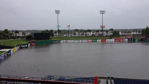
Reports of flooding in Florida is more than I remember. In fact record for most 24 hr rainfall in the U.S is 23".. I think there's a spot in Florida with 17" from Debby alone.
Ditches are filling up and overflowing onto road.
Just a few latest reports:
HAMILTON FL LAW ENFORCEMENT
U.S. HIGHWAY 129 AT COUNTY ROAD 150 IN JASPER CLOSED DUE TO FLOODING.
COLUMBIA FL LAW ENFORCEMENT
INTERSTATE 10 EASTBOUND AT MILE MARKER 301 CLOSED DUE TO STANDING WATER.
BAKER FL TRAINED SPOTTER
3.46 INCHES OF RAINFALL IN THE PAST 5 HOURS. DITCHES IN AREA ARE AT CAPACITY.
BAKER FL BROADCAST MEDIA
4.08 INCHES OF RAINFALL SINCE 5 PM. WATER CROSSING SOME ROADS WEST OF GLEN ST. MARY.
TROPICAL STORM DEBBY CAUSED 7 TORNADOS ACROSS WEST
CENTRAL AND SOUTHWEST FLORIDA ON SUNDAY JUNE 24.
WAKULLA FL PUBLIC
KNEE DEEP WATER UP TO FRONT PORCH. LAWN AND DRIVEWAY NOT VISIBLE. BULK OF RAIN, APPROX 18 INCHES, FELL OVER PAST 2 HOURS.
From NWS Tallahassee (10:04 PM) nwstae-alex.lamers: MEDIA: we could use your help in conveying the urgency of this situation. This is NOT a normal flooding event, particularly in Wakulla County. We are extremely concerned about how this is unfolding.
Using phone so haven't confirmed this. They are trying to evacuate parts of Panhandle Florida. This is not sounding or looking good!! One has to assume this will make the billion dollar disaster club if it keeps up. Problem is, all models don't stop dropping rain over florida. Let's wish them luck and hope for the best and safety.
1146 PM HEAVY RAIN 1 ESE SANBORN 30.07N 84.59W 06/25/2012 M20.10 INCH WAKULLA FL MESONET
20.10 INCHES OF RAIN MEASURED OVER THE LAST 24 HOURS.
Please register to post and access all features of our very popular forum. It is free and quick. Over $68,000 in prizes has already been given out to active posters on our forum. Additional giveaways are planned.
Detailed information about all U.S. cities, counties, and zip codes on our site: City-data.com.

 Please register to participate in our discussions with 2 million other members - it's free and quick! Some forums can only be seen by registered members. After you create your account, you'll be able to customize options and access all our 15,000 new posts/day with fewer ads.


 I believe thats only to 8am Monday.

