Please register to participate in our discussions with 2 million other members - it's free and quick! Some forums can only be seen by registered members. After you create your account, you'll be able to customize options and access all our 15,000 new posts/day with fewer ads.
Debbie will be the 4th Atlantic Tropical system this year. Never before since record-keeping began in 1851 has the fourth tropical storm of any Atlantic Hurricane season formed before July.
Since it's forming in the Gulf, chances are high it will make landfall in the U.S.
"Debby would mean another broken tropical weather record in less than a week. "Zombie" Chris started this record-breaking week by becoming the earliest storm to be named north of a latitude parallel to the border of Virginia and North Carolina Tuesday afternoon."
I haven't heard Accuweather give their model of where its headed so its still a guess. Some of the models have it taking a pretty good track into the southeast and then up through the carolinas. Lets hope its a good soaker like the last one. Keep your fingers crossed that they keep on being minimal storms or non events as hurricanes go.
A great season thus far. Starting out early with the storms continuing to come out .
The pattern is somewhat similar to a couple of 19th century seasons; many things have occurred in 2012 that haven't occurred since 1880's or 90's seasons. None of them obviously featured this many pre-July storms, but then again perhaps they weren't detected as well as they are now. An odd thing that I've noticed is that in recent years it seems to be very difficult for tropical storms to retain their tropical characteristics when they move north, and even the ones that stay tropical tend to be larger with broader windfields with lower maximum winds, almost taking on some non-tropical characteristics. Examples include Bill 2009, Irene 2011, Lee 2011, Ike 2008, and others, with Katrina 2005 being one of if not the first example of this trend. Storms like Camille, Andrew, and Charley which were compact and powerful seem to be a dying breed. I believe this is connected to climate change (towards colder/stormier/eventually drier), and the 19th century analogs are intriguing. I have a hunch this may also tie into how tropical storms can survive over otherwise too-cold waters (including several storms in 2005 and Grace 2009). If they can somehow remain fully tropical while taking on some non-tropical characteristics perhaps they could be "tougher" in colder waters . Anyway, this is one topic I'll leave to the researchers.
About Hurricane Chris, I've seen some rumors where it better fit subtropical than tropical characteristics, at least at some point. Could someone elaborate on that? Anyway, it looks like we're making up for the record-long stretch without a June hurricane (14 seasons; 1996-2009) with Alex in 2010 and Chris in 2012 both being June hurricanes. It's possible that future Debbie will join the June hurricane club if and when it does form and intensify.
The Weather Channel has an article about the "strange" early hurricane season.
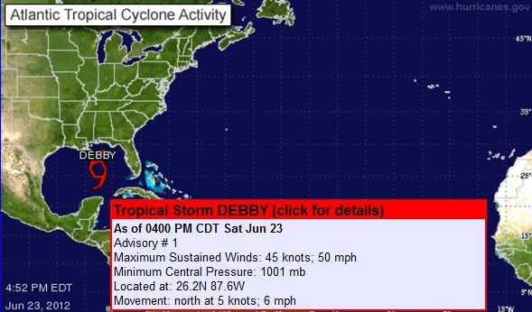
Its offical. Debby forms and a record is broken. Never before have we had a D named storm before July. Nothing major but could pose flooding and surge issues down there. I think it could become a Cat 1 at most.
DISCUSSION AND 48-HOUR OUTLOOK
------------------------------
AIRCRAFT RECONNAISSANCE AND BUOY DATA INDICATE THAT THE AREA OF LOW
PRESSURE IN THE GULF OF MEXICO HAS BECOME TROPICAL STORM DEBBY.
AT 400 PM CDT...2100 UTC...THE CENTER OF TROPICAL STORM DEBBY WAS
LOCATED NEAR LATITUDE 26.2 NORTH...LONGITUDE 87.6 WEST. DEBBY IS
MOVING TOWARD THE NORTH NEAR 6 MPH...9 KM/H. A SLOW NORTHWARD
MOTION IS EXPECTED TONIGHT...FOLLOWED BY A WESTWARD TURN ON SUNDAY.
ON THE FORECAST TRACK...THE CENTER OF DEBBY WILL BE MOVING OVER THE
NORTHERN GULF OF MEXICO DURING THE NEXT FEW DAYS.
MAXIMUM SUSTAINED WINDS ARE NEAR 50 MPH...85 KM/H...WITH HIGHER
GUSTS. THESE WINDS ARE OCCURRING WELL EAST OF THE CENTER OF
CIRCULATION. SOME STRENGTHENING IS FORECAST DURING THE NEXT 48
HOURS.
TROPICAL-STORM-FORCE WINDS EXTEND OUTWARD UP TO 175 MILES...280 KM
TO THE EAST OF THE CENTER.
MINIMUM CENTRAL PRESSURE ESTIMATED FROM RECONNAISSANCE DATA IS 1001
MB...29.56 INCHES.
PREPARATIONS TO PROTECT LIFE AND PROPERTY SHOULD BE COMPLETED
BEFORE CONDITIONS DETERIORATE. THE ONSET OF GUSTY WINDS AND HEAVY
RAINS CAN CAUSE OUTSIDE ACTIVITIES TO BECOME DANGEROUS. SECURE
LOOSE OUTDOOR OBJECTS WHICH CAN BE BLOWN AROUND. IF YOU LIVE IN A
MOBILE HOME...LEAVE IT FOR MORE SUBSTANTIAL SHELTER.
&&
...WINDS...
WINDS ARE EXPECTED TO SLOWLY INCREASE OVER THE NEXT COUPLE OF DAYS
AND PEAK MONDAY THROUGH EARLY TUESDAY. MAXIMUM WINDS ARE FORECAST
TO BE IN THE 25 TO 35 MPH RANGE WITH GUSTS TO 45 MPH POSSIBLE.
RESIDENTS SHOULD MOVE LOOSE ITEMS INDOORS...SUCH AS GARBAGE CANS
AND OUTDOOR FURNITURE...AS THEY WILL BE BLOWN AROUND. NEWLY
PLANTED OR YOUNG TREES AND SHRUBS MAY BE UPROOTED IF NOT SECURED
PROPERLY. ISOLATED POWER OUTAGES WILL BE POSSIBLE.
...STORM SURGE AND STORM TIDE...
TIDE LEVELS WILL RUN 2 TO 3 FEET ABOVE NORMAL BEGINNING SUNDAY
AND LASTING THROUGH AT LEAST TUESDAY...WITH SOME LOCATIONS UP TO 4
FEET ABOVE NORMAL. THE HIGHEST WATER LEVELS WILL OCCUR AT THE
TIMES OF HIGH TIDE.
ON THE LOUISIANA COAST...ROADWAYS AND LOW LYING AREAS OUTSIDE THE
HURRICANE PROTECTION LEVEES WILL EXPERIENCE FLOODING. COASTAL
AREAS AND ACCESS ROADS TO SHELL BEACH...GRAND ISLE...PORT
FOURCHON...AND LEEVILLE WILL BE IMPACTED
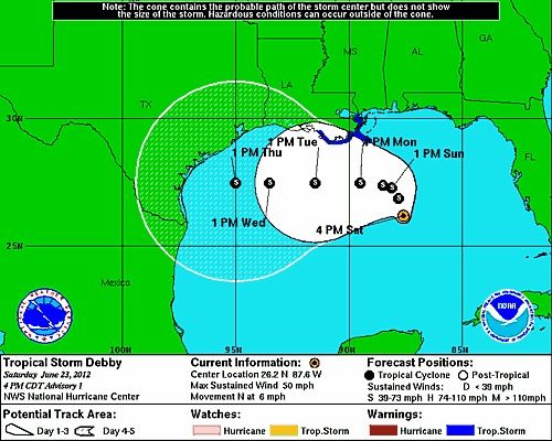
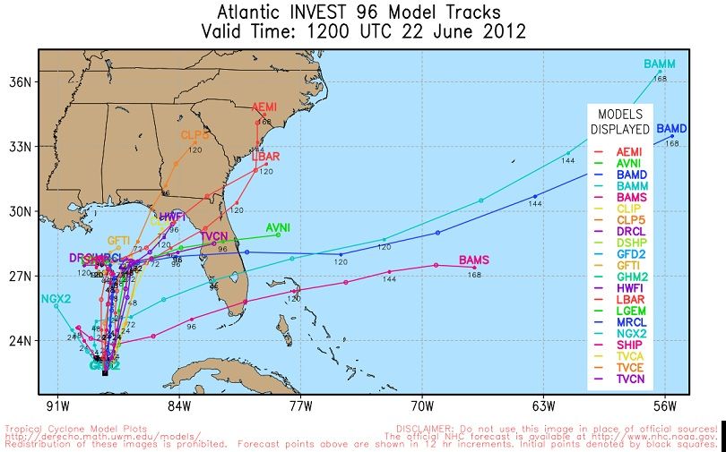
Guess what... NHC and all other forecasting offices changed their tracks. No more Texas. Now landfall should be near Florida Panhandle.
Damage and power outages already happening. 60mph SUSTAINED wind in Florida panhandle coast.
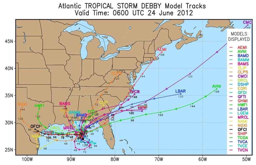
GFS for 2 weeks had it going East. European, Canadien, and all models had it going west into Texas. Bow to the American model now. (if it happens)
The strongest this will become will be CAT1 if it does get to that point. Upper level disturbance is shearing Debby off but Flooding, Wind, and Tornados will be a concern as it has all day already.
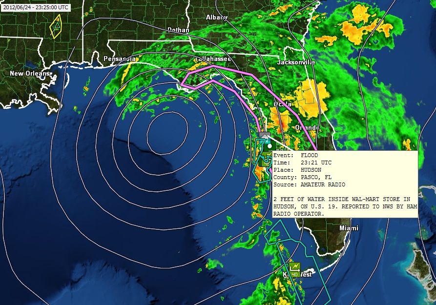
Rainfall totals exceeding 10 inches!
DISCUSSION AND 48-HOUR OUTLOOK
------------------------------
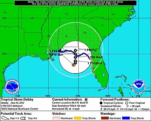
AT 400 PM CDT...2100 UTC...THE CENTER OF TROPICAL STORM DEBBY WAS
LOCATED NEAR LATITUDE 28.4 NORTH...LONGITUDE 85.8 WEST. DEBBY IS
MOVING TOWARD THE NORTHEAST NEAR 3 MPH...6 KM/H. NO SIGNIFICANT
MOTION IS EXPECTED DURING THE COUPLE OF DAYS...BUT THIS FORECAST
CONTINUES TO BE UNCERTAIN.
MAXIMUM SUSTAINED WINDS ARE NEAR 60 MPH...95 KM/H...WITH HIGHER
GUSTS. SOME SLIGHT STRENGTHENING IS POSSIBLE DURING THE NEXT 48
HOURS.
TROPICAL STORM FORCE WINDS EXTEND OUTWARD UP TO 200 MILES...325 KM
FROM THE CENTER.
ESTIMATED MINIMUM CENTRAL PRESSURE IS 993 MB...29.32 INCHES
I'm still holding out on this one becoming a hurricane. It's moving slowly over warm waters, and despite the shear that's a recipe for a lot of intensification. NOAA has Debbie pegged to get up to 70 mph, so it would only take a 5 mph increase over the forecast for it to become a minimal hurricane. Chris did the same thing earlier this month if I remember correctly.
If Debbie becomes a hurricane it will be the first time two or more hurricanes formed in the month of June since the 1968 season. In 1968 Abby and Brenda both were minimal hurricanes. In the 1886 season there were actually 3 hurricanes in June, all of which were Category 2 hurricanes.
Some interesting facts are out there as it relates to June storms and hurricanes. According to Wikipedia, in early June 1816 "a hurricane brushed the Florida Keys, causing the loss of 5 ships. Interestingly, it appears to have been lured northward by an unusual June snowstorm across New England." This is of course the "Year Without a Summer", which seems to have been an active year for Atlantic hurricanes.
Another interesting fact about June hurricanes is that the first Atlantic hurricane ever recorded was a June hurricane in 1494 that made landfall in Hispaniola.
Roof is off just north of Cape Coral on west coast, powers out. Tornado in West Palm Beach. One being reported just south of orlando right now. Flooded streets in Bellview area near Ocala in central Florida.
With how this is stationary, people in Florida better buncker down for a rough 2 days!
Surface winds going West. 850mb winds going north. That equals Spin ups for Tornados!
GFS model has this 2 weeks ago. Who would have thought it would actually happen.
Please register to post and access all features of our very popular forum. It is free and quick. Over $68,000 in prizes has already been given out to active posters on our forum. Additional giveaways are planned.
Detailed information about all U.S. cities, counties, and zip codes on our site: City-data.com.

 Please register to participate in our discussions with 2 million other members - it's free and quick! Some forums can only be seen by registered members. After you create your account, you'll be able to customize options and access all our 15,000 new posts/day with fewer ads.


 .
. . Anyway, this is one topic I'll leave to the researchers.