11Jul19 11aEDT/10aCDT update (continued):
Quick summary: Watches expanded, some Warnings issued, biggest threats: rain/flooding/surge, likely slow development next 24hrs, still poss Cat1 hurricane late Fri night or sometime Saturday, some uncertainty in track/intensity remains.
Stats:
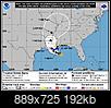
Winds 40mph(65km/h), moving West 5mph(7km/h), pressure 1005mb. Located about 95miles(150km) SSE of mouth of Mississippi River. About 200miles(320km) SE of Morgan City, LA. Tropical Storm force winds (39+mph) extend up to 90miles(150km) mainly just Southeast of storm center.
Barry’s health:
Multiple centers still seen on satellite & by aircraft recon, but looks like one may finally be taking over, so disorganized still. Strongest part of storm by winds is SE of the center currently. Dry air very high up is over the very North Gulf coast East of Louisiana and over ‘center’ of storm, not healthy for Barry. How much this hurts Barry remains unclear. Shear is still over the storm which isn’t helping it organize either. So it’s a mess, we’ll see how it does through the day but it’s not going anywhere fast at the moment. Friday looks better for Barry to start developing though but questions remain on where and what it’ll become.
Warnings (expected to occur within 36hrs or less, rush to finish preparations):
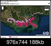
-Storm Surge Warning mouth of Atchafalaya River to Shell Beach Louisiana.
-Tropical Storm Warning mouth of Pearl River (MS/LA border) to Morgan City, LA.
Watches (possible within 48hours or less, prepare in case):
-Storm Surge Watch Shell Beach, LA to MS/AL border.
-Storm Surge Watch mouth of Atchafalaya River to Intracoastal City, LA.
-Hurricane Watch mouth of Mississippi River to Cameron, LA.
-Tropical Storm Watch LA/MS border to MS/AL border.
-Tropical Storm Watch Lake Pontchartrain, Lake Maruepas & New Orleans metro.
Surge possible heights (rise in water above normal tide levels):
-mouth of Atchafalaya River to Shell Beach, LA: 3-6ft
-Shell Beach, LA to MS/AL border: 2-4ft
-Intracoastal City to mouth of Atchafalaya River: 2-4ft
-Lake Pontchartrain: 1-3ft
Additional rainfall:
-Scattered 10-15”, isolated 20”.
-Don’t drive around barricades. Don’t drive into water covered roads. Just a few inches of fast moving water can carry away most vehicles. You don’t know if the road is still there or if structure under it exist anymore. In the US most flood deaths are vehicle related still.
Winds:
Barry expected to intensify, how much still uncertain. Tropical Storm winds (39+mph, but less then 74mph) expected to start reaching portions of the coast Friday morning. 39ish doesn’t sound like much and it’s not by itself but the wear and tear for hours and hours even at just that amount is enough to see scattered downed trees and power lines. Due to flood risk, crews may not go to fix these until the storm has cleared after this weekend.
Tornado:
Small brief lived tornadoes are common in landfalling tropical systems. Most usually form in the NE corner of the storm. These may start by tonight and risk may rise into the weekend.
Safety:
Head all calls for evacuation if told. Prepare for possible downed power lines and trees even well inland. 9-1-1 emergency services may not even try to respond during peak of storm for their own safety. Questions remain for who will see what and what final shape Barry ends up in but time is running out to prepare. Landfall Saturday. Biggest threat is scattered rains and widespread flood potential from the coast and well inland & storm surge. Cell towers typically have battery backup for 24+hrs, use texting if calls cannot get through during storm, sometimes works better. Have multiple ways to receive warnings/info, sometimes systems break in storms. Don’t drive around barricades. In large scale events such as landfalling tropical systems, police do not have the time and resources to block all flooded or tree fallen roads.
As always, official storm stats, cone maps, and any tropical Watches/Warnings come from the US National Hurricane Center every 3 hours (2,5,8&11am/pmEDT, 1,4,7&10am/pmCDT) daily here:
https://www.nhc.noaa.gov/
Edit: adding these 2 images:

 Please register to participate in our discussions with 2 million other members - it's free and quick! Some forums can only be seen by registered members. After you create your account, you'll be able to customize options and access all our 15,000 new posts/day with fewer ads.


