Autumn 2012 Thread (Southern Hemisphere) (lows, summer, april, cold)
Please register to participate in our discussions with 2 million other members - it's free and quick! Some forums can only be seen by registered members. After you create your account, you'll be able to customize options and access all our 15,000 new posts/day with fewer ads.
Snowing down to 900 m ASL in southern NSW right now (Jindabyne, Cooma Airport) . This is much better than expected. Sydney will receive some of this cold air overnight, expected maximum tomorrow 19 or 20C and windy, which will feel winter like compared to what we've been having. Like clockwork, this coincides with Perth's near record heat.
16C today here... we had heavy showers, hail, thunder and even sunshine.... and wind gusts up to 133km/h in Bass Strait at the islands just offshore from Victoria (this comes after 145km/h recorded on Friday night).
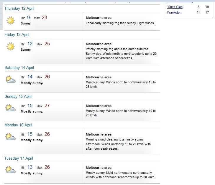
17C tomorrow, cold icy showers and crap.
then 26C and sunny during the second half of the week.
Last edited by Flight Simmer; 04-09-2012 at 06:59 AM..
Location: The Valley Of The Sun just east of Canberra
414 posts, read 798,177 times
Reputation: 362
A lovely 9.1C this morning with an icy wind from the SW, this cold shot has exceeded expectations for a change. Unfortunately it will be short lived with temps back up to 26C for the weekend, though nights are definitely trending cooler now. Dew points are expected to remain in the low to mid teens all week so hopefully hot nights are a thing of the past.
After the hot start to April where maximum temperatures have averaged 30C/86F, it has now cooled down with only 25C/77F expected today, and 9C/48F tomorrow morning.
Unfortunately it has been nearly 3 weeks since measurable rainfall has fallen here. Yesterday we had a chance, but of course a little gap in the line of showers went over us, as usual, so Dalby ended up with nothing. Hopefully this horrible dry spell ends soon, because I do not want another dry April, which has been very common in recent years. The average rainfall for April used to be about 40mm, but in the last 20 years the average has been only 20mm.
Brett Dutschke, Tuesday April 10, 2012 - 10:07 EST
Southeastern Australia has been dealt such a cold change that it has effectively turned summer into winter in a matter of a few days.
Some places, including Sydney, are having their coldest April morning in four years, just a few days after going through one of their warmest April weeks on record.
Sydney dipped to 10 degrees at six o'clock this morning, its coldest April morning since 2008 and five below the average minimum. Only last Saturday the city warmed to 28 degrees, which completed a week's worth of 25 degrees-or-warmer, the equal-longest run of 25-degree April days on record.
The area with the biggest turnaround in the past week has been across the interior of New South Wales, Victoria and South Australia, where the temperature has dropped more than 30 degrees.
Persistent northerly winds last week have given way to bitterly cold southerly winds in a hurry due to the strongest cold front since spring.
In just four days, Hopetoun in the Victorian Mallee has cooled from a summer-like 35 degrees on Good Friday to a wintry three degrees this morning.
Other centres which have cooled more than 30 degrees in the past week are Mildura and Nhill in western Victoria, Wagga Wagga, Parkes and Cobar in western NSW, Renmark in SA and Ouse in Tasmania.
Wagga Wagga is just one of many places which had its warmest April spell in seven years last week and now its coldest April morning in four years.
The chill that has now taken over southeastern Australia has been much more noticeable in the wind. The wind has been so strong at times it has made it feel five-to-10 degrees colder than the actual temperature.
When people were heading to work this morning the wind chill made Sydney feel like seven degrees, Canberra like two degrees, Melbourne like five and Hobart like four degrees.
Southerly winds will lose their bite during today as they gradually ease under the influence of a growing high pressure system. But this easing of the wind will allow some places to become colder tonight and tomorrow morning than they were last night and this morning. Patches of frost will form over the inland.
For the rest of the week, temperatures will return closer to normal as southerly winds turn more easterly then northerly.
This warming will cause snow on the Alps and on the Tasmanian highlands to melt quickly. Snow fell below the 600-metre height in Tasmania and below about 1200 metres in Victoria. Mt Baw Baw received about 40-centimetres worth, its biggest dump since spring.
- Weatherzone
This is the glorious thing about autumn, why this is my favourite time of the year.
We will even be seeing some single digit figures for minimum temps in the Hunter Valley this week!
Things will warm up again for the week-end, but the temps have lost the sting of summer, and the humidity is gone.
Another morning below 10C here (9.6C). Bewdiful. However back to mid 20's by the weekend, looking like another lengthy Indian Summer coming up though nights are cooler. Basically because of the absence of cloud over Central Aus, most days will be well above average for most places barring the odd cold front.
It ended up getting to 6.1C/43F here last night. It was the first night where I needed a blanket on my bed. Further west, Roma reached 1.3C/34F - pretty cold for Queensland in April! Probably a light frost on the ground there.
It should still warm up to the low to mid 20's today, but unlike southern Australia it doesn't look like any abnormal warmth/heat will be experienced here over the next week with temperatures staying near average or slightly below.
Another morning below 10C here (9.6C). Bewdiful. However back to mid 20's by the weekend, looking like another lengthy Indian Summer coming up though nights are cooler. Basically because of the absence of cloud over Central Aus, most days will be well above average for most places barring the odd cold front.
Thank god..... THANK GOD!!!!! 4 days of this icy wintry showery overcast crap is more than enough. Looking forward to thawing out under blue skies.
Please register to post and access all features of our very popular forum. It is free and quick. Over $68,000 in prizes has already been given out to active posters on our forum. Additional giveaways are planned.
Detailed information about all U.S. cities, counties, and zip codes on our site: City-data.com.

 Please register to participate in our discussions with 2 million other members - it's free and quick! Some forums can only be seen by registered members. After you create your account, you'll be able to customize options and access all our 15,000 new posts/day with fewer ads.

 . This is much better than expected. Sydney will receive some of this cold air overnight, expected maximum tomorrow 19 or 20C and windy, which will feel winter like compared to what we've been having. Like clockwork, this coincides with Perth's near record heat.
") Hopefully this horrible dry spell ends soon, because I do not want another dry April, which has been very common in recent years. The average rainfall for April used to be about 40mm, but in the last 20 years the average has been only 20mm.
Hopefully this horrible dry spell ends soon, because I do not want another dry April, which has been very common in recent years. The average rainfall for April used to be about 40mm, but in the last 20 years the average has been only 20mm.