Please register to participate in our discussions with 2 million other members - it's free and quick! Some forums can only be seen by registered members. After you create your account, you'll be able to customize options and access all our 15,000 new posts/day with fewer ads.
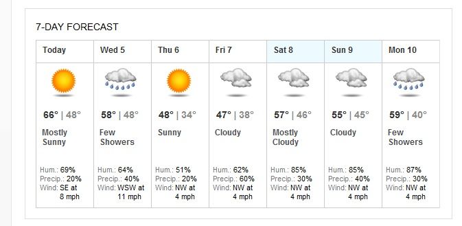
That's funny. I'm looking at at NWS Forecast for Northern Colorado (KFNL)that goes through next Monday and there is not the mention of a single flake of snow.
It shows a slight chance Saturday night through Sunday night. The weather forecast usually wait until the models are more certain or just when it's closer. The Euro Model forecast Hurricane Sandy 9 days in advance but the weather didn't make forecast off it until 4 or so days.
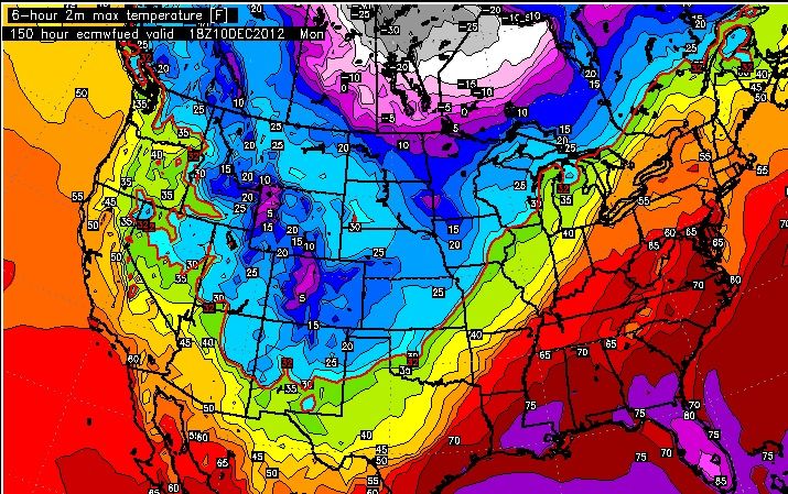
Well, quite a few of the ensembles show the AO going to -5, which indicates a truckload of cold coming down to the U.S. Curiously, truckloads of cold haven't been showing up on the models, though a much troughier/stormier pattern is indicated for the central part of the country and New England. The East Coast (ex-New England) and South will be pretty much out of the action, but from what I've seen a pattern change is definitely coming around midmonth. And it doesn't look zonal, either. This is an example from the latest GFS run. It's at the end of the run, but what's shown is rather typical for the upcoming pattern:
Notice how the troughiness is concentrated in the Plains and the Northwest, and to a lesser extent New England. The rest of the country is pretty much out of it. While it isn't a classic meridional pattern, it doesn't look zonal, either. It appears that the cold that is currently concentrated in Western Canada will bleed downward to the PacNW and the Plains, but it seems unable to go all the way down, so to speak.
Since Christmas is 21 days away, it's hard to tell what the pattern will be. It could be that same sort of "meh" pattern that's on the models now, it could be a much colder pattern forced by the AO, or it could be something entirely different (such as a classic cold west/warm east pattern). I myself would lean towards the upcoming pattern persisting but gradually expanding in extent (cold reaching further south and east) for Christmas, but that's just a guess.
Quote:
Originally Posted by tom77falcons
And the pattern can just as easily switch back to warm again. This is why winter std deviation temps are so high. If was only always cold, our std deviation would be much lower.
Not likely. Once patterns are established they typically last for at least 1-2 weeks, and for what it's worth the long-range models have the mid-month change persisting through at least the 20th. This current warm pattern will probably have lasted about 2 weeks, and some patterns can last for as long as 8 weeks. How long this one will last (1, 2, 4, or 6 weeks) is of course one big question mark.
Keep in mind I'm talking about a pattern - within patterns there are still variations (look through the last 3 winters in your area for good examples). If cold or warmth only lasts for 2 days or so it isn't really a pattern, is it? What I'm looking at is projected to last for at least a week, which would qualify as a pattern change, as opposed to a temporary cold or warm shot, which wouldn't.
Quote:
Originally Posted by wavehunter007
Well in my particular case…the fun WILL last; I only have until December 12th or so before I’m down in southern Florida. Things look pretty mild right until I depart. I haven’t see snow since last Feb – and I would like to keep it that way.
After that, it can snow/rain/cold/wind….etc I really don’t care. I’ll be sitting under a coconut palm with the sun blazing down, watching the mail boats and cruise ships head into the Bahamas - lol
I see you're making out like a migratory bird. Good luck.
You still have to watch out for snow. But seriously, although freezes and snow can reach South Florida, you're pretty secure from snow when you get to South Florida; almost all of Florida's snow falls in the north (just as one would expect). South Florida has never recorded snow accumulation, though flurries do occur on very rare occasions.
It shows a slight chance Saturday night through Sunday night. The weather forecast usually wait until the models are more certain or just when it's closer. The Euro Model forecast Hurricane Sandy 9 days in advance but the weather didn't make forecast off it until 4 or so days.
OK, I was looking at the graphic through Saturday.
Well, quite a few of the ensembles show the AO going to -5, which indicates a truckload of cold coming down to the U.S. Curiously, truckloads of cold haven't been showing up on the models, though a much troughier/stormier pattern is indicated for the central part of the country and New England. The East Coast (ex-New England) and South will be pretty much out of the action, but from what I've seen a pattern change is definitely coming around midmonth. And it doesn't look zonal, either. This is an example from the latest GFS run. It's at the end of the run, but what's shown is rather typical for the upcoming pattern:
Notice how the troughiness is concentrated in the Plains and the Northwest, and to a lesser extent New England. The rest of the country is pretty much out of it. While it isn't a classic meridional pattern, it doesn't look zonal, either. It appears that the cold that is currently concentrated in Western Canada will bleed downward to the PacNW and the Plains, but it seems unable to go all the way down, so to speak.
Since Christmas is 21 days away, it's hard to tell what the pattern will be. It could be that same sort of "meh" pattern that's on the models now, it could be a much colder pattern forced by the AO, or it could be something entirely different (such as a classic cold west/warm east pattern). I myself would lean towards the upcoming pattern persisting but gradually expanding in extent (cold reaching further south and east) for Christmas, but that's just a guess.
Not likely. Once patterns are established they typically last for at least 1-2 weeks, and for what it's worth the long-range models have the mid-month change persisting through at least the 20th. This current warm pattern will probably have lasted about 2 weeks, and some patterns can last for as long as 8 weeks. How long this one will last (1, 2, 4, or 6 weeks) is of course one big question mark.
Keep in mind I'm talking about a pattern - within patterns there are still variations (look through the last 3 winters in your area for good examples). If cold or warmth only lasts for 2 days or so it isn't really a pattern, is it? What I'm looking at is projected to last for at least a week, which would qualify as a pattern change, as opposed to a temporary cold or warm shot, which wouldn't.
I see you're making out like a migratory bird. Good luck.
You still have to watch out for snow. But seriously, although freezes and snow can reach South Florida, you're pretty secure from snow when you get to South Florida; almost all of Florida's snow falls in the north (just as one would expect). South Florida has never recorded snow accumulation, though flurries do occur on very rare occasions.
Of course you see a cold pattern, and again of course you see it expanding. Nothing new there.
Right now it is 65F and sunny. I prefer 50's in winter, but I certainly take this over 20's. Almost all long range forecasts for our area have winter going back and forth, but averaging at or slightly above normal.
I'm sure if you were a long range forecaster in our area you would be the only one calling for a polar winter so far out of range you would be ignored.
This looks like a pattern, but not the kind you wish for:
The Euro Torch.... well at least for East of the Rockies.
Latest Euro max temps for next Monday. Basically, after a cold front comes through we get seasonable temps in the East but the SouthEast ridge builds again and the trough stays out west.
How often does Florida get to the mid 80s in December?
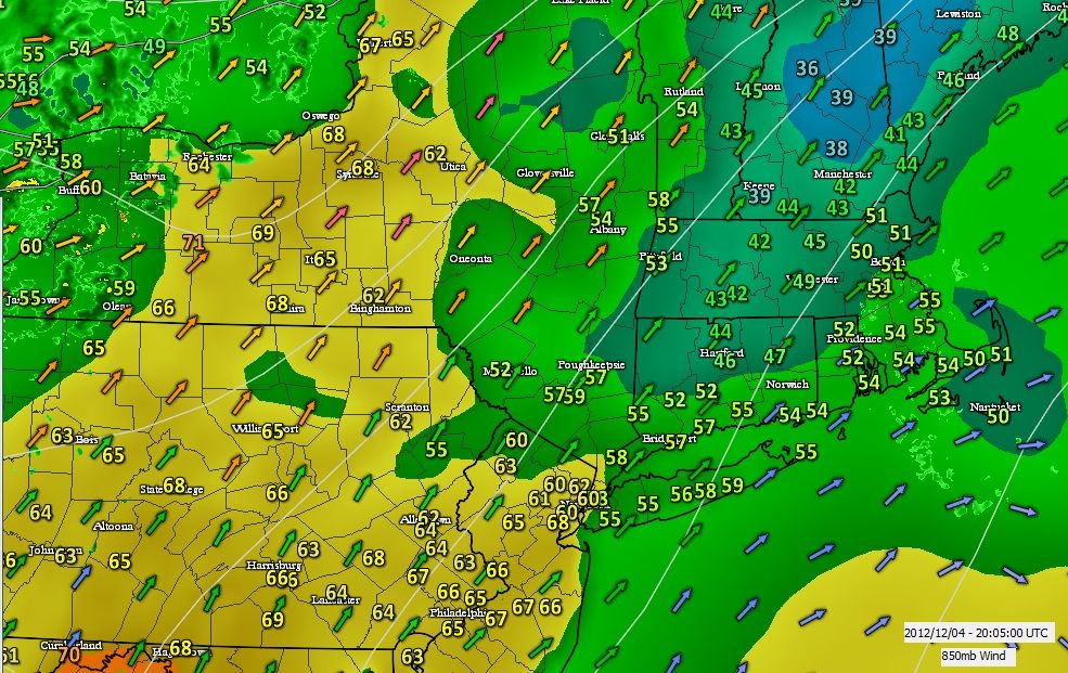
December 4, 2012. Temp check 3pm EST... Just wanted to point out something cool.
First notice northern CT not making it out of the 40s. Basically a 3 day warmup down to 1.
Second and more importantly... look at the arrow colors and directions. They are from the south but notice where the yellows oranges and pink arrows are. Basically where it warmed up. Those colors indicate over 40mph at the 5000' level. It gave the south warmth a better push north.
The Euro Torch.... well at least for East of the Rockies.
Latest Euro max temps for next Monday. Basically, after a cold front comes through we get seasonable temps in the East but the SouthEast ridge builds again and the trough stays out west.
How often does Florida get to the mid 80s in December?
That actually looks like decent cold for Colorado and and out west. They need some cold.
Forecast for early next week suggest some cold weather in Colorado with highs at least 10 F below average and lows around average.
This would be a welcome change, but what we really need is snow in the mountains. There are some models that are trying to put some snow in the mountains around the middle of the month and I hope that they are on target for a change. Last year we had snow on the ground in Loveland 29 days in December. There was a bumper crop of snow, but not much very cold air at all. The mountains were starved for snow last year, and another repeat this year will be a disaster.
Please register to post and access all features of our very popular forum. It is free and quick. Over $68,000 in prizes has already been given out to active posters on our forum. Additional giveaways are planned.
Detailed information about all U.S. cities, counties, and zip codes on our site: City-data.com.

 Please register to participate in our discussions with 2 million other members - it's free and quick! Some forums can only be seen by registered members. After you create your account, you'll be able to customize options and access all our 15,000 new posts/day with fewer ads.


 . But seriously, although freezes and snow can reach South Florida, you're pretty secure from snow when you get to South Florida; almost all of Florida's snow falls in the north (just as one would expect). South Florida has never recorded snow accumulation, though flurries do occur on very rare occasions.