Please register to participate in our discussions with 2 million other members - it's free and quick! Some forums can only be seen by registered members. After you create your account, you'll be able to customize options and access all our 15,000 new posts/day with fewer ads.
"There have been some interesting hail events the past few weeks. The town of Santa Rosa, New Mexico was hammered with up to a foot of hail accumulation last Wednesday July 3. Snowplows had to be employed to clear the highways. On June 25th a very rare, if not unprecedented, hailstorm struck Singapore. This is an updated blog to one I posted two years ago about the greatest hailstorms on record and the largest individual stones yet measured."
Bringing this up again. I understand there are different forecasters within the office that write up the discussions but it seems like everytime I look they are trying to avoid saying anything relating to "cooler" weather.
NATIONAL WEATHER SERVICE BURLINGTON VT
646 AM EDT TUE JUL 9 2013
LONG TERM /THURSDAY NIGHT THROUGH MONDAY/... AS OF 424 AM EDT TUESDAY...THE LONG AWAITED PATTERN CHANGE APPEARS TO BE ON THE HORIZON...WITH A MAINLY DRY EXTENDED PORTION OF THE FORECAST.
TEMPERATURES WILL START OUT BELOW NORMAL AT THE START OF THE PERIOD...THEN TREND BACK ABOVE NORMAL TOWARDS THE END OF THE PERIOD.
Now take a look and please point out to me where NWS New York mentions anything regarding relief? I mean temps have been in the 90s with a real feel of upper 90s/100s. Why not say its going to get cooler or drier in that nature? Instead they go on and on about the rain chances and then have to mention the heat and humidity coming back. Are You kidding me????
In fact, they mention the warm temps on Wednesday then skip to Monday?????????
NATIONAL WEATHER SERVICE NEW YORK NY
725 AM EDT TUE JUL 9 2013
VERY WARM AND INCREASINGLY HUMID CONDITIONS ON WED...WITH TEMPS IN THE MID TO UPPER 80S NYC/NJ METRO AND INTERIOR...WITH LOWER TO MID 80S ALONG THE COAST IN SOUTHERLY SYNOPTIC FLOW.
.LONG TERM /WEDNESDAY NIGHT THROUGH MONDAY/... UNSETTLED WEATHER ON TAP FOR THE MIDDLE TO THE END OF THE WEEK AS LOW PRES TRACKING ACROSS EASTERN CANADA DRAGS A COLD THROUGH THE REGION ON THURSDAY. THE FIRST ROUND OF SHOWERS AND POSSIBLE THUNDERSTORMS WILL TAPER OFF IN THE FIRST HALF OF WEDNESDAY NIGHT....AND THEN ADDITIONAL SHOWERS AND POSSIBLE THUNDERSTORMS WILL DEVELOP ON THURSDAY AS WEAK LOW PRES DEVELOPS ALONG THE FRONT AND SLIDES THROUGH THE REGION. WITH PWATS AROUND 2"...CAN EXPECT HEAVY RAIN. SCATTERED TO NUMEROUS SHOWERS/TSTMS WILL IMPACT THE REGION THROUGHOUT THE DAY...TAPERING OFF LATE.
COLD FRONT WILL BE THROUGH THE REGION THURSDAY NIGHT AND BECOMES NEARLY STATIONARY EAST OF THE AREA. H5 TROUGH/SHORTWAVE MOVES RIGHT OVER THE AREA ON FRIDAY AND THEN STALLS OUT OVER THE AREA. EVEN THOUGH HIGH PRES BUILDS IN AT THE SFC...WILL HAVE TO KEEP AT LEAST CHANCE POPS IN THE FORECAST FOR THE WEEKEND DUE TO THIS UPPER LEVEL SYSTEM OVER THE AREA. RETURN FLOW SETS UP BRINGING AN INCREASE IN THE HEAT AND HUMIDITY AGAIN ON MON
Give me a friggin break. So you mention the return of heat at the end of your long range forecast yet you never mentioned the cooler temps coming before that. It's so transparent.
Last edited by Cambium; 07-09-2013 at 06:25 AM..
Reason: Added time & Date of Discussion
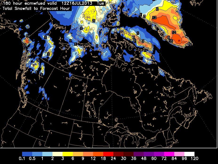
It's not every day that we see a snowfall map for Greenland. Thanks.
I assume most of it is on higher elevations, on the ice sheet, away from inhabited locations. Still very different from last year, when it was warm enough even the highest elevations of the ice sheet to melt, though only for a day.
Some interesting data on the melt season for the Greenland ice sheet so far this year:
Please register to post and access all features of our very popular forum. It is free and quick. Over $68,000 in prizes has already been given out to active posters on our forum. Additional giveaways are planned.
Detailed information about all U.S. cities, counties, and zip codes on our site: City-data.com.

 Please register to participate in our discussions with 2 million other members - it's free and quick! Some forums can only be seen by registered members. After you create your account, you'll be able to customize options and access all our 15,000 new posts/day with fewer ads.


") Instead they go on and on about the rain chances and then have to mention the heat and humidity coming back. Are You kidding me????
Instead they go on and on about the rain chances and then have to mention the heat and humidity coming back. Are You kidding me???? 


