Please register to participate in our discussions with 2 million other members - it's free and quick! Some forums can only be seen by registered members. After you create your account, you'll be able to customize options and access all our 15,000 new posts/day with fewer ads.
Cold in Duluth here this morning, with a low of -13F (-25C). Currently 21F (-6C) and the area is under a winter weather advisory until midnight Tuesday. There has not been a high exceeding 38F (3C) this month, and there is none forecast for the next week. Compare this with a year ago (3/17/12), when the high was 75F (24C) and the low a mild 40F (4C).
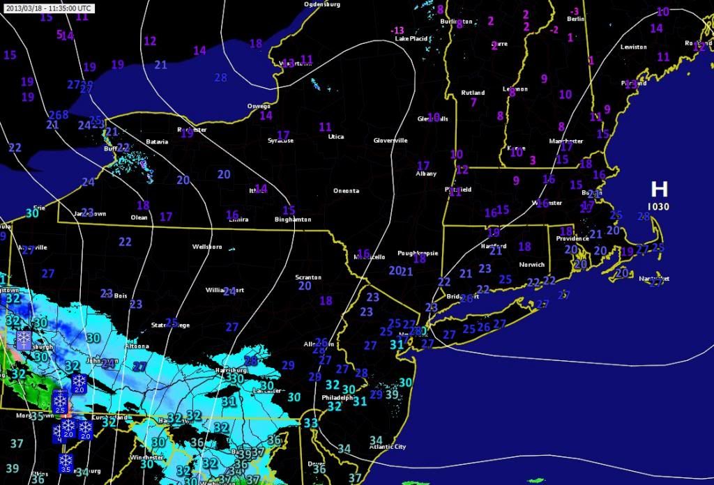
7:30am Temps March 18 2013
Teens made it as far south as CT (Litchfield County and Windham County)
I bottomed at 22.3°F near the coast here. Wind chill was at 18°. Light winds helped keep temps near actual. Radiational cooling happened last night and temps dropped hard.
7:30am Temps March 18 2013
Teens made it as far south as CT (Litchfield County and Windham County)
I bottomed at 22.3°F near the coast here. Wind chill was at 18°. Light winds helped keep temps near actual. Radiational cooling happened last night and temps dropped hard.
Yep, we had winds too overnight. Never reached the forecast 9°F, only 13°F briefly. 18°F right now. Cold looks more seasonable by next weekend.
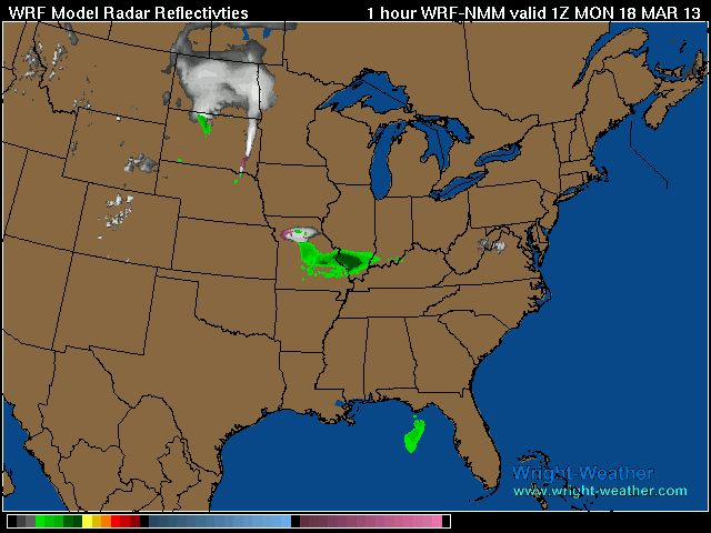
Future radar loop based off the WRF model. White is snow
Changeover happens in the morning for everyone south of Vermont. So some areas that actually get 3" to accumulate will wake up with nothing on the ground and they will think it didnt snow. lol
Even National Weather Service using it in their discussions. They also note that the Euro slows the warming of lower levels which will mean prolonged snow.
THE LOW LEVEL WARM ADVECTION WILL WIN OUT FROM SW TO NE WITH
MAINLY SNOW DEVELOPING ACROSS MAINLY THE WESTERN 3/4 OF THE TRI-
STATE BY EVENING. COULD SEE A FEW POCKETS OF RAIN IN THE NYC HEAT
ISLAND TO START - BUT WOULD EXPECT EVAPORATIVE COOLING TO ALLOW
FOR TEMPERATURES TO APPROACH THEIR WET BULB VALUES AND THE
PRECIPITATION TO CHANGE TO ALL SNOW EVEN THERE. BY LATE AFTERNOON
EXPECT ACCUMULATIONS OF 1 TO 2 INCHES ACROSS ORANGE AND PUTNAM
COUNTIES WITH UP TO AN INCH - MAINLY ON GRASSY SURFACES ACROSS THE
REMAINDER OF THE AREA N/W OF NYC.
HIGHS TODAY WILL OCCUR BEFORE THE ONSET OF PRECIPITATION - USED A
BLEND OF MIXING DOWN FROM 925 HPA WITH NAM AND ECMWF 2-METER
TEMPERATURES AND A BLEND OF MET/MAV/ECS GUIDANCE WITH VALUES
EXPECTED TO BE 10-15 DEGREES BELOW NORMAL.
THERE IS STILL SOME UNCERTAINTY ON EXACT TIMING OF CHANGE OVER
FROM SNOW TO SLEET/FREEZING RAIN AND THEN TO ALL RAIN IN THIS
REGION - NOTING 00Z ECMWF IS EVEN SLOWER WITH WARM UP OF LOW
LEVELS THAN 12Z ECMWF/00Z CMC-GLOBAL/21Z SREF - BUT CONFIDENCE IN
IMPACT IS HIGH ENOUGH TO GO WITH HEADLINES AS OUTLINED ABOVE.
Dewpoints in single digits and below zero CT northwards. Dry as a bone. There's moisture waaay up above but drying up on the way down fast. So it wil take a few hours to prime up the atmosphere.
But its pretty darn cold out there for midday mid March
Please register to post and access all features of our very popular forum. It is free and quick. Over $68,000 in prizes has already been given out to active posters on our forum. Additional giveaways are planned.
Detailed information about all U.S. cities, counties, and zip codes on our site: City-data.com.

 Please register to participate in our discussions with 2 million other members - it's free and quick! Some forums can only be seen by registered members. After you create your account, you'll be able to customize options and access all our 15,000 new posts/day with fewer ads.


")


