Please register to participate in our discussions with 2 million other members - it's free and quick! Some forums can only be seen by registered members. After you create your account, you'll be able to customize options and access all our 15,000 new posts/day with fewer ads.
It's 58 F right now and it was only supposed to be 54! Even I wasn't expecting it to be that warm, in fact I thought since it's cloudy that it would be BELOW the forecast!
In other news some light drizzle has started here. It'll be a little more steady later in the afternoon and evening, but not too much, just moderate rainfall.
-6C with snow melting in the sunshine in New Jersey is due to a stronger sun angle in those parts, which is particularly apparent late in the season. I've read that this is due to the increased amount of solar radiation (UV, IR, visible), which increases the temperature of the snowpack (the part that's exposed to sunlight, anyway). If it was late December you would see far less (if any) melting at -6C.
It's 58 F right now and it was only supposed to be 54! Even I wasn't expecting it to be that warm, in fact I thought since it's cloudy that it would be BELOW the forecast!
In other news some light drizzle has started here. It'll be a little more steady later in the afternoon and evening, but not too much, just moderate rainfall.
Posts like this help me learn whats happening in other areas. The cloudy/warm makes sense now.
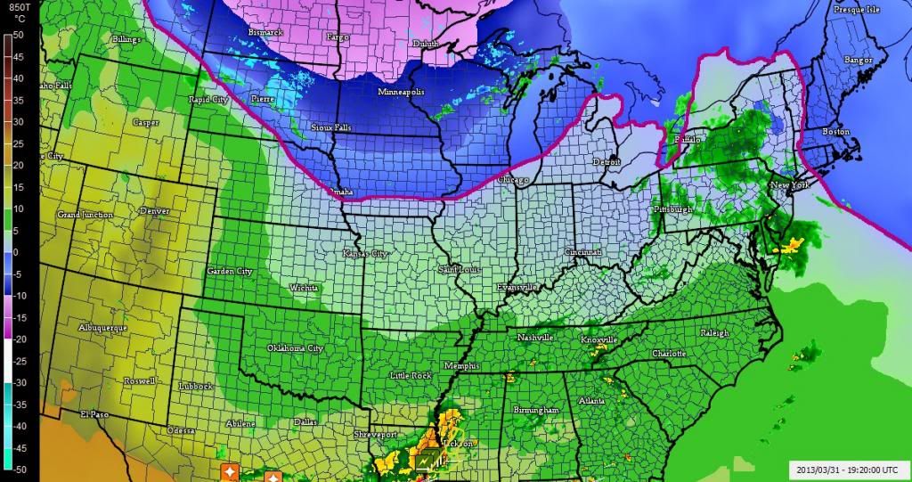
Remember I kept pointing out the 850mb freezing line was down in the Gulf? and that the temps at 4000' were below freezing over us and very cold? Clouds covered the sun and surface cooled down...
Well take a look at how that freezing line retreated northwards AND how we're above freezing at 4000' now.. So even with the clouds, I'm thinking there's no real cold air to keep the surface cold so the clouds are like a blanket instead keeping us warmer.
You can find the 850mb temps here. (just looks different) . Under "basic UA" click on 850mb analysis SPC Hourly Mesoscale Analysis#
* ACCUMULATIONS...7 INCHES OR MORE ARE POSSIBLE IN 12 HOURS...OR
9 INCHES OR MORE IN A 24 HOUR TIME FRAME.
* MAXIMUM SNOWFALL RATES...VERY LOCALIZED RATES MAY REACH AN INCH
AN HOUR AT TIMES TONIGHT THROUGH TUESDAY NIGHT.
* TIMING...A LAKE EFFECT SNOW BAND OR BANDS WILL DEVELOP
TONIGHT... POSSIBLY BREAKING UP DURING THE DAY TUESDAY...THEN
REORGANIZING TUESDAY NIGHT WITH THE POTENTIAL FOR LOCALIZED
MODERATE TO HEAVY SNOW.
Still winter in Marion ND, Current temp 9F / -13C Snow expected by Wednesday. Icy cold temps expected to be with us until after the snow and then may warm up to near 32F / 0C
How can average march high in downtown Winnipeg be 6c?
When the average march high is -1c at the airport.
I can see it being alittle warmer, maybe 0c but not 7c warmer.
And Winnipeg's airport in closer to downtown than most cities.
Converted to fahrenheit, Winnipeg airport march average high is 30F
And you're stating that the downtown average march high is 43F
I say, no way. Even Fargo, North Dakota (200+ miles south) the average march high is only 37F
And Winnipeg november average high is also -1c, not 3c
Please register to post and access all features of our very popular forum. It is free and quick. Over $68,000 in prizes has already been given out to active posters on our forum. Additional giveaways are planned.
Detailed information about all U.S. cities, counties, and zip codes on our site: City-data.com.

 Please register to participate in our discussions with 2 million other members - it's free and quick! Some forums can only be seen by registered members. After you create your account, you'll be able to customize options and access all our 15,000 new posts/day with fewer ads.

 Even I wasn't expecting it to be that warm, in fact I thought since it's cloudy that it would be BELOW the forecast!