Please register to participate in our discussions with 2 million other members - it's free and quick! Some forums can only be seen by registered members. After you create your account, you'll be able to customize options and access all our 15,000 new posts/day with fewer ads.
Nice. what I just don't get tho is why 5 inches of rain is a problem in Chicago when all that happens in miami is widespread minor street flooding and a few Isolated pockets of moderate flooding.
Nice. what I just don't get tho is why 5 inches of rain is a problem in Chicago when all that happens in miami is widespread minor street flooding and a few Isolated pockets of moderate flooding.
Chicago averages 39 inches of rain annually, whereas Miami averages 61 inches. In Miami if a spot is submerged after 5 inches of rain, you couldn't build on it, whereas in Chicago (where 5 inches is abnormal) you can. It's all about what a location is used to and the normal water levels. As a more extreme example, think about what would happen if Death Valley got 61 inches of rain in one year - the whole place would flood catastrophically and whole towns would be underwater due to the same weather that Miami is accustomed to - but the key is that they are not accustomed to it.
As an analogy, 5 inches of rain in Chicago would probably be more equivalent to 8 inches in Miami. It probably doesn't work proportionally using the averages like that, but that might give you a rough idea.
Meanwhile, check out these maps. Below is TWC's map of current snow cover. Obviously it is abnormally large for this time of year, and strangely enough it looks like there's more snow now than there was in early January 2012. Keep in mind that it's now April 18.
Notice the big temperature drop observed over the south central region. A 35F temperature decrease in 24 hours is something to write home about anywhere in the United States. Also note the 20-25F warmup in the Rust Belt.
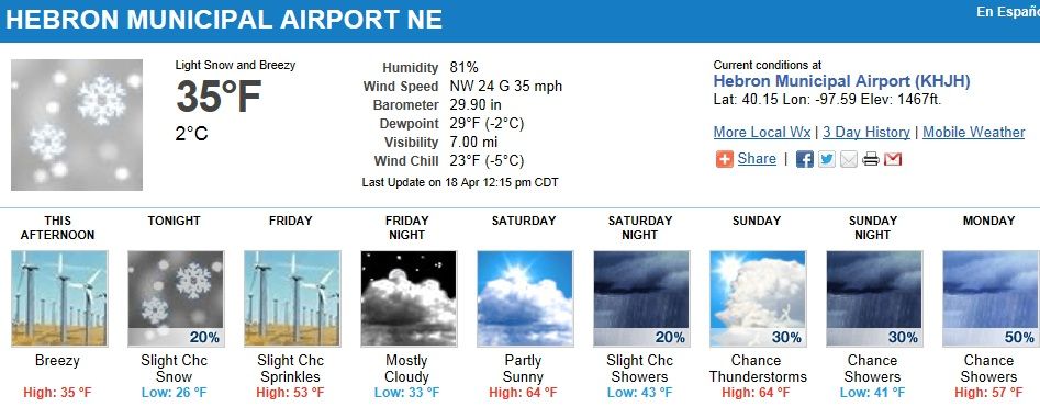
Also notice the huge area that is now experiencing significant wind, which stretches almost from coast to coast. This is one of the most widespread wind events I've ever seen, and it's all being driven by the developing storm system in the Midwest.
Nice. what I just don't get tho is why 5 inches of rain is a problem in Chicago when all that happens in miami is widespread minor street flooding and a few Isolated pockets of moderate flooding.
Similar to what PM said. 5 inches of rain wouldn't be a problem here, because most places that flood regularly wouldn't be built on. The wettest towns (a generous term) in this area would have 130 inches a year and with much higher totals in the hills but seldom flood, unless there is heavy rain - 15+ inches a day.
Most heavy rain damage here, occurs from slips and log jams.
Below is TWC's map of current snow cover. Obviously it is abnormally large for this time of year, and strangely enough it looks like there's more snow now than there was in early January 2012. Keep in mind that it's now April 18.
NO doubt it is a bit above normal for this time of year...but keep in mind that much of that snowcover in CO and WY is at rather high elevation. It's not uncommon for their to be snow up there. I'm no ski fan, but isn't spring skiing a big deal up in that neck of the woods? It might be because no other areas hold snowcover much after mid March. Not really sure though.
"Windsor - Leamington - Essex County
3:04 PM EDT Thursday 18 April 2013
At 2:40 PM EDT, meteorologists are tracking a line of severe thunderstorms currently through Detroit.
These storms are about to cross the border into the Windsor area.
The storms will continue to move eastward and northeastward and are expected to reach a line from Goderich to Chatham to Point Pelee by 4:00 PM EDT.
Damaging winds, large hail, torrential dowpours, and frequent cloud to ground lightning are associated with these storms.
Emergency Management Ontario recommends that you take cover immediately, if threatening weather approaches.
Strong wind gusts and hail can damage property and cause injuries. Local downpours can cause flash floods.
Go indoors and move away from windows and skylights. Avoid areas of the building that could be affected by falling debris such as tree limbs. Stay on the lower floor of your home or building and if the storm is particularly severe go to the basement.
Avoid driving through water on roads. Even shallow fast moving water across a road can sweep a vehicle away.
Remember, severe thunderstorms can produce tornadoes."
Miami has much better storm drains and have measures to control the water.
Please register to post and access all features of our very popular forum. It is free and quick. Over $68,000 in prizes has already been given out to active posters on our forum. Additional giveaways are planned.
Detailed information about all U.S. cities, counties, and zip codes on our site: City-data.com.

 Please register to participate in our discussions with 2 million other members - it's free and quick! Some forums can only be seen by registered members. After you create your account, you'll be able to customize options and access all our 15,000 new posts/day with fewer ads.