Please register to participate in our discussions with 2 million other members - it's free and quick! Some forums can only be seen by registered members. After you create your account, you'll be able to customize options and access all our 15,000 new posts/day with fewer ads.
A few 50 highs will have little impact on melting the snow if most of the nights remain below freezing.
The biggest fear is we will have a few more snow days with below freezing nights until Mid May and than a sudden hot spell with even the nights being in the 50s the flooding would be disastrous.
yeah, not gonna be good. Lets hope there's more sunny days than warm or rainy days coming up. This way evapoartion can do its thing instead of a quick melt.
Looking at the stat from revious post the 2nd & 3rd latest 50 degree days came during a late Spring flood year.
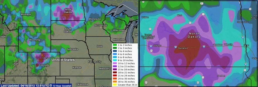
And looking at the snowfall (not snow pack) from last 72hrs, 1 foot+ is widespread.
Everything was covered in snow just two days ago. 10+°C sunny highs have only just melted most of it and grass is already starting to go green in exposed areas. Plant growth is really hitting the ground running in this late spring, trying to catch up.
yeah, not gonna be good. Lets hope there's more sunny days than warm or rainy days coming up. This way evapoartion can do its thing instead of a quick melt.
Looking at the stat from revious post the 2nd & 3rd latest 50 degree days came during a late Spring flood year.
And looking at the snowfall (not snow pack) from last 72hrs, 1 foot+ is widespread.
Love your videos as always.
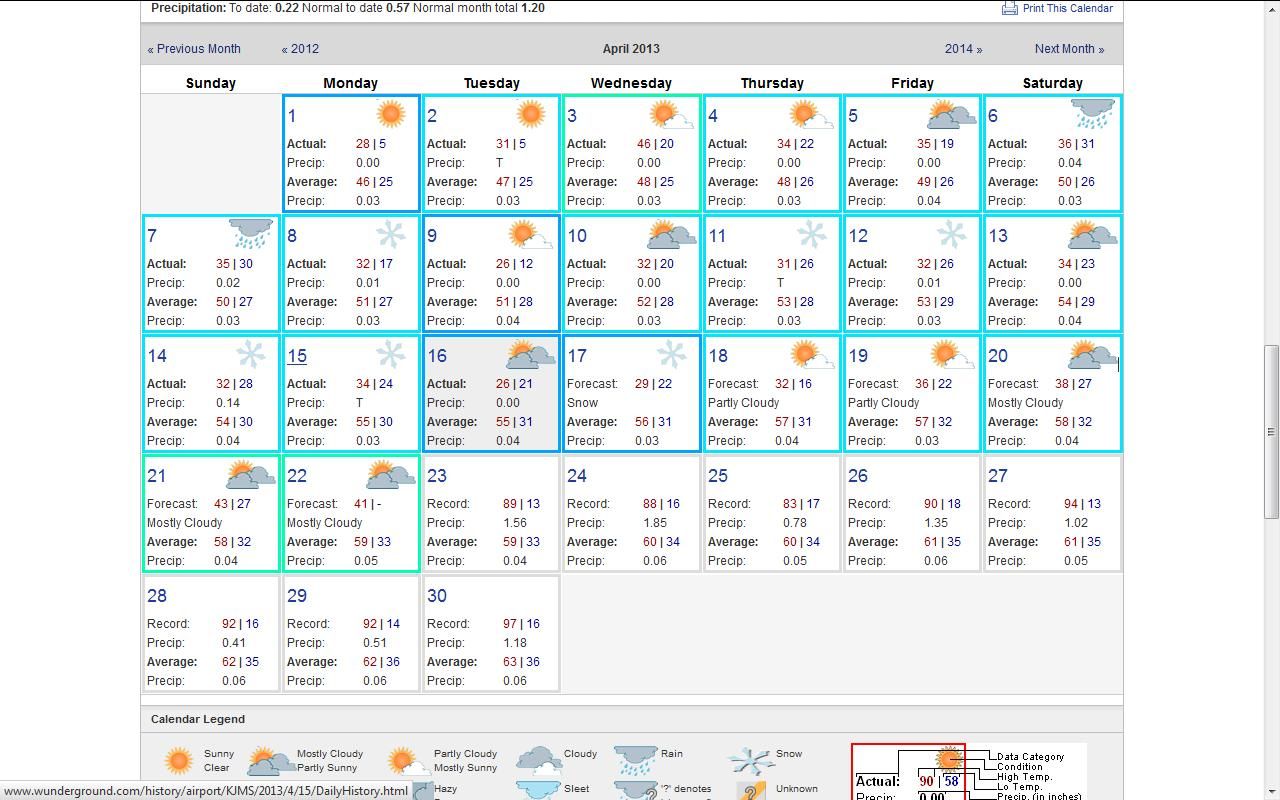
The forecast is calling for more snow. The calender only shows predicted forecast up to the 21st. No thawing out in the foreseeable prediction. No 50 degree any time soon either. The calender only shows the prediction up to the 21st. The rest of the days show the historical averages and/or records.
Looks like we will be walloped with floods in May and June.
No doubt it has been a cool early spring in many areas. I think you’ll see 77 F/25 C after the 24th, as there looks to be a pattern shift that will allow even far northern areas (Dakota’s, Great Lakes, Upper New England) to get pretty warm.
The list is interesting – it looks like if you exclude last year (record warmth) and 2010, the 3rd week of the month is when you see your first 25 C or higher. I would love to see the same months for NWS stations like Trenton, NJ or Wilmington, DE – my guess is that they would see their first 25 C or higher by late March?
60's and 70's already? That just shows how warm most of the East Coast is. In Fargo the warmest temperature so far this year has been 43F (source). That figure is unusually cool, but if you want a slow Spring, Fargo is the place to look.
Well you know me....as a WWF I can't say I wish I was anywhere where it has only been in the 40's so far this year. Still, that sounds below normal even for the northern Plains?.
I've been in Florida most of the winter, 60's and 70's (mostly 70's F) are winter highs to me. I have no desire to see highs below 60 F after April 1st here in southern Connecticut/NYC
62 F here right now, and the sun feels nice and strong
It is gonna rain tonight again so I guess the snow will probably be gone on the hills near me. I was kinda hoping that the snow would've lasted to May, but I doubt it will now not with all this rain. There was quite a big covering 3 days ago and then it rained really really heavy all night and then last night, now there is only a small patch.
Maybe the snow will stick to May on the higher hills.
It is amazing how slow spring comes up in your area/New England.
I just checked several NWS stations on the East Coast...every single NWS station from the NY/NJ/CT area southward has already cracked 80 F (26 C)…but Boston only hit 73 F, Worcester only 66 F, and Concord, NH a pathetic 63 F. It’s amazing that in the distance from Trenton, NJ (has hit 87 F already) to Worcester, MA, a distance of less than 250 miles, there is a 21 F difference.
Not true for New Jersey. KFWN (Sussex) reached 79 F.
Still, that sounds below normal even for the northern Plains?
Since records began in Fargo, every year except 1881 and 2013 has had at least one 50F day by this point in time, so it's very abnormal. 1881 finally reached 50F on April 17, and it looks like 2013 will break that record by at least 6 days. Per the GFS, it looks likely that Fargo will crack 50F sometime between the 23th and the 30th, but on the other hand it looks like a close shave - just 3F colder than modeled and it won't make it to 50F. It would be neat if the first 50F didn't occur until May - the record books will have to be ripped apart (metaphorically speaking, of course).
In any case temperatures will stay safely below 50F for the next week, 60F looks unlikely until May, and normal to colder than normal conditions look to persist for at least the next 20 days.
No doubt it has been a cool early spring in many areas. I think you’ll see 77 F/25 C after the 24th, as there looks to be a pattern shift that will allow even far northern areas (Dakota’s, Great Lakes, Upper New England) to get pretty warm.
You got any models or links supporting the pattern shift? Some concrete evidence for my hopes will be welcome.
Quote:
The list is interesting – it looks like if you exclude last year (record warmth) and 2010, the 3rd week of the month is when you see your first 25 C or higher. I would love to see the same months for NWS stations like Trenton, NJ or Wilmington, DE – my guess is that they would see their first 25 C or higher by late March?
Close enough, but it's variable.
For Trenton:
Spring 2013: 25°C on April 8
Spring 2012: 25°C on March 13
Spring 2011: 27°C on March 18
Spring 2010: 25°C on March 21
Spring 2009: 26°C on April 18
Spring 2008: 25°C on April 17, 24°C on April 10
Spring 2007: 28°C on March 27
Because it's earlier, the heat will feel a bit more fleeting.
You got any models or links supporting the pattern shift? Some concrete evidence for my hopes will be welcome.
.
Curious myself unless thats a personal opinion again. You can click on any long range model and nothing supports that right now. In fact, a trough is more common which means seasonably chilly.
Click on any of the GFS runs and notice the first 3 images. Blues = below normal temps at 850mb which translate to cool/seasonably temps at surface.
My personal opinon stands. We will stay seasonable with times of chillier than normal and times of warmer than normal but if anyone is looking for that continued Torch in the East they better be patient..I dont see it for the next 3 weeks at least.
As averages go up thats what I'm expecting. Highs of 60s/70s Mid Atlantic to Northeast. 50s/60s for New England. Lows of 40s/50s with some 30s too.
Please register to post and access all features of our very popular forum. It is free and quick. Over $68,000 in prizes has already been given out to active posters on our forum. Additional giveaways are planned.
Detailed information about all U.S. cities, counties, and zip codes on our site: City-data.com.

 Please register to participate in our discussions with 2 million other members - it's free and quick! Some forums can only be seen by registered members. After you create your account, you'll be able to customize options and access all our 15,000 new posts/day with fewer ads.


 Still, that sounds below normal even for the northern Plains?.


 (metaphorically speaking, of course).
