Please register to participate in our discussions with 2 million other members - it's free and quick! Some forums can only be seen by registered members. After you create your account, you'll be able to customize options and access all our 15,000 new posts/day with fewer ads.
Look at that drought in the central us if it holds on could be a scorcher.... even more proof is that every record breaking hot summer we have had I was in the middle east and I have plans to go for a good portion of the summer. 2007 when we had hottest month on record in August? Not here. 2010 when we had 3 straight months of nothing but 90s? Not here. 2012? Not here. Although there is one exception which was the cool summer of 2014.
True, but that's not much of a drought though, and could easily be wiped out by spring rains.
We need to pay attention to the ENSO. It's forecast to go neutral this spring and most of summer, possibly moving towards a weak El Nino during the second half of summer into start of fall
Here is an animation to what El Nino does with precip based on varying degrees of strength
Basically a weak or moderate El Nino reduces rainfall in the Central US and a strong/super increases it.
Speaking of drought our snow drought is now 2nd longest on record. Longest is 83 days
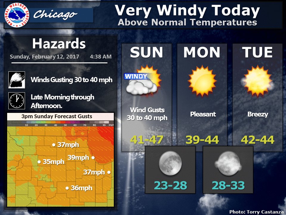
We are going to be the "Windy City" today
Northeast East gets buried with more snow (especially Boston)
Thunderstorms in the forecast Tuesday. The severe risk is uncertain depending on how far inland the warm air mass goes.
Quote:
DISCUSSION...High pressure remains situated off the East Coast
this morning while an area of low pressure is moving into the
southern Great Lakes Region. A cold front is draped to the sw of
the low into the Texas Panhandle. Between these systems a very
warm and moist air mass is being lifted north with early morning
temps in the upper 60s to low 70s which is above the normal highs.
Widespread thin fog is also noted over the region. Will keep the
dense fog adv for now, as the visibilities continue to slowly
decrease.
Today the aforementioned ridge will sink south and east while the
the low moves into the Great Lakes. This will swing the front
south and through the area tonight. A few showers will be possible
as the boundary moves through the region.
This front will stall in the gulf through Monday then begin to
lift north early Tuesday. Also during Sunday and Monday, an upper
lvl low will move across Northern Mexico into West TX and NM.
Ahead of the upper low a frontal wave will develop along the
stalled frontal boundary along the coast in South Texas. This weak
surface low will move northeast through Tuesday pulling the front
back north into SE TX and South LA. Widespread rain and
thunderstorms are expected as the low moves through, but the main
question will be how far north will the warm moist air mass be
pulled inland. South and east of the low track enough instability
will be present to possibly allow for a few strong storms Tuesday
afternoon/evening. The latest round of models suggest that all but
the northern edge of the cwa will be in the warm sector.
The low will depart early Wednesday and temperatures are expected
to fall back to seasonable averages before warming back up during
the coming weekend.
Been all snow here since 8am. 1/2" new snow. On trees and back roads now.
Current radar and temps. Virginia in the 60s. NYC reporting ice now. I'm pretty much at the snow/no snow border. lol
I'm at freezing rain/borderline.
I was just watching the Weather Network....Canadian Maritimes are going to be hit hard starting
tonight....combo or very high winds (over 100 k/h) and tons of snow ....50 plus cm (18 inches or more),
they are used to snowstorms but this one could be big, even for them.
Monday looks like they'll have another "no school day", they had 2 such days just last week,
kids are probably not complaining
Please register to post and access all features of our very popular forum. It is free and quick. Over $68,000 in prizes has already been given out to active posters on our forum. Additional giveaways are planned.
Detailed information about all U.S. cities, counties, and zip codes on our site: City-data.com.

 Please register to participate in our discussions with 2 million other members - it's free and quick! Some forums can only be seen by registered members. After you create your account, you'll be able to customize options and access all our 15,000 new posts/day with fewer ads.