Please register to participate in our discussions with 2 million other members - it's free and quick! Some forums can only be seen by registered members. After you create your account, you'll be able to customize options and access all our 15,000 new posts/day with fewer ads.
Snow is falling across northern Indiana. Cloudy and cold here in central Indiana. Woke up to 13F. Tonight should get down into the single digits with clear skies. We might see snow this weekend Friday night into Saturday, maybe a couple inches anyway. We shall see since it's still several days out.
Hopefully it will impact us here in southern Indiana, but still early, clipper scenario is most likely. Modified blowtorch chinook off in the Great Plains will act as a funnel with the storm track with colder air off to the northeast and northern Great Lakes.
Wasted Storm Friday or a 300 mile shift West is coming?
What a Bomb.. Sub 980mb low and enough cold air around over land for sure.
Clipper dives south into Ohio Valley crosses over Kentucky and into North Carolina. That Clipper merges with a coastal storm well off the coast and blows up
NWS NY Disco regarding this Arctic Airmass...Here it comes::
Quote:
Area Forecast Discussion
National Weather Service New York NY
102 PM EST Mon Jan 10 2022
A dip in the upper level jet stream south of the region will
coincide with an arctic front moving across tonight into
Tuesday. A frigid airmass will be moving into the region tonight
and lasting into midweek. Around a 1040mb high out in the North
Central US will be building in on Tuesday and then overhead on
Tuesday night before moving south of the region on Wednesday.
Aloft, the highly amplified flow tonight into Tuesday will
flatten out Tuesday night into Wednesday with a return to more
zonal flow. The main upper level jet will shift farther north to
be over the general region late Tuesday through Wednesday.
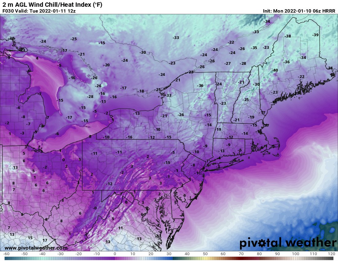
A significant period of sub-freezing temperatures is expected
with forecast temperatures not expected to get above freezing
until during the day Wednesday. Sub zero wind chills are
expected late tonight into Tuesday morning with special weather
statement out to address this. Wind chills do not drop into
advisory thresholds but will have minimum values near 0 to -10.
With temperatures sitting below freezing for 72 hrs, and a good
10- 20 degrees below normal for 48 hrs, potential for poorly
insulated water pipes to freeze and related structural flooding
issues. Existing research indicate temperatures below 20F are
the threshold for poorly insulated pipes to freeze and burst or
crack. These conditions will occur for around 24 to 30 hrs for
city/coast and around 30 to 40 hrs interior.
Clouds will continue to increase tonight. The arctic front
moves across tonight with some possible snow showers or snow
flurries, especially towards Eastern Long Island and Southeast
CT where low level moisture will be relatively greater. Moisture
will be limiting factor overall though as the NW gusty flow
continues.
Behind the arctic front, coldest airmass of the winter season will
be moving into the region with the continued NW gusty flow. It will
be quite frigid and blustery. Temperatures will be well below
freezing tonight through Tuesday night and into early Wednesday.
NAEFS indicates 850mb standardized anomalies getting to 2 to 3
standard deviations below normal with values of around -20 C early
Tuesday morning.
Lows tonight will be very cold, down into the single digits to
lower teens for most locations with low to mid teens for NYC,
consistent with national blend of models dataset. These values
will be between 10 and 15 degrees below normal. Wind chills will
be lowering to near to several degrees below zero. Parts of the
interior are forecast to have near -10 degree wind chills.
Regarding the Storm... they mention what I said except in more details...
Quote:
.LONG TERM /WEDNESDAY NIGHT THROUGH SUNDAY/...
Flow aloft over eastern North America will amplify during this time frame,
with a trough digging out of central Canada and sending a cold front
toward the local area, while a trailing northern stream shortwave trough
digs toward the SE US, inducing surface cyclogenesis off the SE coast.
Attm have only slight chance PoP for some snow showers mainly with
the cold frontal passage, though it may be a close shave for steady
snow across the forks of Long Island and far SE CT as the precip
shield with the offshore storm may get very close. Phasing of these
two upper systems appears to occur a little too late to have much
more impact than that and to usher in colder air on a brisk N flow.
High pressure building out of E Canada and the upper Midwest to our
west on Fri should then briefly settle over the area while
weakening. Attention then turns to a potent shortwave trough
aloft/Alberta clipper low digging out of W Canada and the N Plains
that should induce sfc cyclogenesis over the SE US or right along
the Carolina coast Sat night. Future track of this system will
depend on the evolution of the earlier offshore storm as it moves up
into the Canadian Maritimes. GFS nrn stream is weaker and allows
this low to scoot to the south with little if any impact, while the
ECMWF maintains a stronger "50-50" low that would lock in cold air
across the Northeast and provide more of an upstream block, with a
slower and more northerly progression of the srn stream low.
Forecast follows NBM at that time range, which brings chance PoP in
a bit too soon Sat afternoon/evening, but its chance PoP for snow on
Sunday looks reasonable.
Snow is falling across northern Indiana. Cloudy and cold here in central Indiana. Woke up to 13F. Tonight should get down into the single digits with clear skies. We might see snow this weekend Friday night into Saturday, maybe a couple inches anyway. We shall see since it's still several days out.
Quote:
Originally Posted by GraniteStater
Hopefully it will impact us here in southern Indiana, but still early, clipper scenario is most likely. Modified blowtorch chinook off in the Great Plains will act as a funnel with the storm track with colder air off to the northeast and northern Great Lakes.
Theres always a snow hole somewhere. Hopefully gets filled in soon. Maybe with the clippers coming next 10 days
Been hot but might could experience some cooler weather. Rained a bit today with the front passing in.
Heavy rain northeast of you. Skipped my area and built up inland thanks to the heating of the day.
Please register to post and access all features of our very popular forum. It is free and quick. Over $68,000 in prizes has already been given out to active posters on our forum. Additional giveaways are planned.
Detailed information about all U.S. cities, counties, and zip codes on our site: City-data.com.

 Please register to participate in our discussions with 2 million other members - it's free and quick! Some forums can only be seen by registered members. After you create your account, you'll be able to customize options and access all our 15,000 new posts/day with fewer ads.