Forks of the River, Tennessee
Submit your own pictures of this place and show them to the world
- OSM Map
- General Map
- Google Map
- MSN Map

| Males: 1,108 | |
| Females: 1,064 |
| Median resident age: | 36.3 years |
| Tennessee median age: | 35.9 years |
Zip code: 38560
| Forks of the River: | $60,631 |
| TN: | $65,254 |
Estimated per capita income in 2022: $35,242 (it was $19,228 in 2000)
Forks of the River CCD income, earnings, and wages data
Estimated median house or condo value in 2022: $238,089 (it was $84,000 in 2000)
| Forks of the River: | $238,089 |
| TN: | $284,800 |
Forks of the River, TN residents, houses, and apartments details
Detailed information about poverty and poor residents in Forks of the River, TN
Compare current foreclosures near Forks of the River, TN:
| Photo | Address | Area | Beds / Baths | Price | Details |
|---|---|---|---|---|---|

|
#1
Flatt Rock Rd
Lebanon, TN 37090
|
1,494 sq. feet
|
2 baths 3 beds |
show details | |

|
#2
Hunter Ave
Carthage, TN 37030
|
1,680 sq. feet
|
2 baths 3 beds |
show details | |

|
#3
S Lovers Ln
Lebanon, TN 37090
|
1,040 sq. feet
|
1 baths - beds |
show details | |

|
#4
Horseshoe Bend Ln
Elmwood, TN 38560
|
1,380 sq. feet
|
1 baths - beds |
show details | |

|
#5
Water Plant Rd
Baxter, TN 38544
|
1,260 sq. feet
|
1 baths - beds |
show details | |

|
#6
Old Baxter Rd
Silver Point, TN 38582
|
2,548 sq. feet
|
1 baths - beds |
show details | |

|
#7
Old Baxter Rd
Silver Point, TN 38582
|
1,305 sq. feet
|
1 baths - beds |
show details | |

|
#8
1st Ave N
Baxter, TN 38544
|
1,590 sq. feet
|
1 baths - beds |
show details | |

|
#9
Lebanon Hwy
Lebanon, TN 37087
|
1,425 sq. feet
|
1 baths - beds |
show details | |

|
#10
Hillwood Acres
Alexandria, TN 37012
|
1,080 sq. feet
|
1 baths - beds |
show details |
| Photo | Address | Area | Beds / Baths | Price | Details |
|---|---|---|---|---|---|

|
#11
Buffalo Valley Rd
Baxter, TN 38544
|
1,530 sq. feet
|
2 baths - beds |
show details | |

|
#12
Dixon Springs Cir
Dixon Springs, TN 37057
|
1,161 sq. feet
|
1 baths - beds |
show details | |

|
#13
Pleasant Shade Hwy
Pleasant Shade, TN 37145
|
1,568 sq. feet
|
2 baths - beds |
show details | |

|
#14
Carthon Jones Ln
Gainesboro, TN 38562
|
1,520 sq. feet
|
2 baths - beds |
show details | |

|
#15
Carthage Hwy
Lebanon, TN 37087
|
1,792 sq. feet
|
2 baths - beds |
show details | |

|
#16
Indian Creek Rd
Whitleyville, TN 38588
|
644 sq. feet
|
1 baths - beds |
show details | |

|
#17
Edwards Ln
Bloomington Springs, TN 38545
|
1,104 sq. feet
|
1 baths - beds |
show details | |

|
#18
Mccoinsville Rd
Gainesboro, TN 38562
|
1,308 sq. feet
|
2 baths - beds |
show details | |

|
#19
Salt Lick Creek Rd
Pleasant Shade, TN 37145
|
2,880 sq. feet
|
1 baths - beds |
show details | |

|
#20
Westgate Rd
Cookeville, TN 38501
|
1,632 sq. feet
|
2 baths - beds |
show details |
| Photo | Address | Area | Beds / Baths | Price | Details |
|---|---|---|---|---|---|

|
#21
Fort Blount Rd
Hartsville, TN 37074
|
1,328 sq. feet
|
1 baths - beds |
show details | |

|
#22
Charlton Sq
Cookeville, TN 38501
|
1,706 sq. feet
|
2 baths - beds |
show details | |

|
#23
Holmes Creek Rd
Smithville, TN 37166
|
1,856 sq. feet
|
2 baths - beds |
show details | |

|
#24
Jake Dr
Cookeville, TN 38501
|
2,624 sq. feet
|
3 baths - beds |
show details | |

|
#25
Shady Dr
Smithville, TN 37166
|
1,200 sq. feet
|
1 baths - beds |
show details | |

|
#26
Moore Ln
Dowelltown, TN 37059
|
1,268 sq. feet
|
2 baths - beds |
show details | |

|
#27
Brown Ln
Gainesboro, TN 38562
|
840 sq. feet
|
1 baths - beds |
show details | |

|
#28
Talpha Dr
Dowelltown, TN 37059
|
1,270 sq. feet
|
1 baths - beds |
show details | |

|
#29
Echo Valley Dr
Cookeville, TN 38501
|
1,624 sq. feet
|
2 baths - beds |
show details | |

|
#30
Parker Branch Rd
Dixon Springs, TN 37057
|
2,312 sq. feet
|
1 baths - beds |
show details |
| Photo | Address | Area | Beds / Baths | Price | Details |
|---|---|---|---|---|---|

|
#31
Gayle Cir
Cookeville, TN 38501
|
1,040 sq. feet
|
1 baths - beds |
show details | |

|
#32
Tara Dr
Cookeville, TN 38501
|
1,392 sq. feet
|
2 baths - beds |
show details | |

|
#33
Blue Bird Dr
Brush Creek, TN 38547
|
1,122 sq. feet
|
1 baths - beds |
show details | |

|
#34
W Main St
Alexandria, TN 37012
|
1,364 sq. feet
|
1 baths - beds |
show details | |

|
#35
Bethany Rd
Baxter, TN 38544
|
1,204 sq. feet
|
1 baths - beds |
show details | |

|
#36
Ensor Hollow Rd
Buffalo Valley, TN 38548
|
2,096 sq. feet
|
1 baths - beds |
show details | |

|
#37
Dixon Springs Hwy
Carthage, TN 37030
|
1,566 sq. feet
|
1 baths - beds |
show details | |

|
#38
Wilburn Ln
Carthage, TN 37030
|
2,151 sq. feet
|
2 baths - beds |
show details | |

|
#39
Temperance Hall Hwy
Hickman, TN 38567
|
1,820 sq. feet
|
2 baths - beds |
show details | |

|
#40
Temperance Hall Hwy
Hickman, TN 38567
|
1,280 sq. feet
|
1 baths - beds |
show details |
| Photo | Address | Area | Beds / Baths | Price | Details |
|---|---|---|---|---|---|

|
#41
Park Ave
Carthage, TN 37030
|
2,184 sq. feet
|
1 baths - beds |
show details | |

|
#42
Eagle Ridge Rd
Granville, TN 38564
|
1,800 sq. feet
|
1 baths - beds |
show details | |

|
#43
Second Ave E
Carthage, TN 37030
|
985 sq. feet
|
1 baths - beds |
show details | |

|
#44
Tanglewood Rd
Carthage, TN 37030
|
1,480 sq. feet
|
2 baths - beds |
show details | |

|
#45
Jackson Ave
Carthage, TN 37030
|
2,030 sq. feet
|
1 baths - beds |
show details | |

|
#46
Maple St
Gordonsville, TN 38563
|
1,133 sq. feet
|
2 baths - beds |
show details | |

|
#47
Walnut Dr
Carthage, TN 37030
|
1,200 sq. feet
|
1 baths - beds |
show details | |

|
#48
Hull Ave
Carthage, TN 37030
|
1,582 sq. feet
|
2 baths - beds |
show details | |

|
#49
Hillcrest Dr N
Carthage, TN 37030
|
1,184 sq. feet
|
1 baths - beds |
show details | |

|
Check over 1 million property listings on Foreclosure.com!
|
browse all offers | |||

- 1,95595.4%White alone
- 602.9%Black alone
- 170.8%Two or more races
- 110.5%American Indian alone
- 50.2%Hispanic
- 20.10%Other race alone

Races in Forks of the River detailed stats: ancestries, foreign born residents, place of birth
 Recent articles from our blog. Our writers, many of them Ph.D. graduates or candidates, create easy-to-read articles on a wide variety of topics.
Current Local Time: CST time zone
Land area: 56.4 square miles.
Population density: 39 people per square mile (very low).

| Forks of the River CCD: | 0.4% ($370) |
| Tennessee: | 0.8% ($715) |
Nearest city with pop. 50,000+: Murfreesboro, TN  (38.3 miles , pop. 68,816).
Nearest city with pop. 200,000+: Nashville-Davidson, TN (49.9 miles , pop. 545,524).
Nearest city with pop. 1,000,000+: Chicago, IL (401.0 miles , pop. 2,896,016).
Nearest cities:
), ), ), ), ), )Latitude: 36.22 N, Longitude: 85.87 W
Area code commonly used in this area: 615


| Here: | 2.8% |
| Tennessee: | 3.0% |

- Construction (11.8%)
- Metal & metal products (10.5%)
- Transportation equipment (8.7%)
- Accommodation & food services (6.8%)
- Educational services (5.3%)
- Truck transportation (5.1%)
- Health care (4.4%)

- Construction (17.9%)
- Metal & metal products (14.1%)
- Transportation equipment (11.1%)
- Truck transportation (6.3%)
- Agriculture, forestry, fishing & hunting (5.1%)
- Public administration (4.7%)
- Building material & garden equipment & supplies dealers (3.3%)

- Accommodation & food services (15.0%)
- Health care (9.0%)
- Educational services (8.7%)
- Social assistance (7.7%)
- Finance & insurance (7.4%)
- Metal & metal products (4.6%)
- Transportation equipment (4.6%)

- Driver/sales workers and truck drivers (8.8%)
- Assemblers and fabricators (8.6%)
- Metal workers and plastic workers (8.6%)
- Other production occupations, including supervisors (6.5%)
- Material recording, scheduling, dispatching, and distributing workers (4.3%)
- Other sales and related occupations, including supervisors (3.6%)
- Other management occupations, except farmers and farm managers (3.6%)

- Driver/sales workers and truck drivers (12.3%)
- Metal workers and plastic workers (11.0%)
- Other production occupations, including supervisors (8.5%)
- Assemblers and fabricators (7.6%)
- Material recording, scheduling, dispatching, and distributing workers (6.0%)
- Construction traders workers except carpenters, electricians, painters, plumbers, and construction laborers (5.8%)
- Vehicle and mobile equipment mechanics, installers, and repairers (5.1%)

- Assemblers and fabricators (10.1%)
- Other office and administrative support workers, including supervisors (7.9%)
- Other sales and related occupations, including supervisors (4.9%)
- Other management occupations, except farmers and farm managers (4.6%)
- Metal workers and plastic workers (4.6%)
- Health technologists and technicians (4.6%)
- Other food preparation and serving workers, including supervisors (4.6%)
Average climate in Forks of the River, Tennessee
Based on data reported by over 4,000 weather stations


(lower is better)

Air Quality Index (AQI) level in 2023 was 69.0. This is about average.
| City: | 69.0 |
| U.S.: | 72.6 |

Ozone [ppb] level in 2023 was 33.7. This is about average. Closest monitor was 14.3 miles away from the city center.
| City: | 33.7 |
| U.S.: | 33.3 |

Particulate Matter (PM2.5) [µg/m3] level in 2022 was 6.46. This is better than average. Closest monitor was 20.4 miles away from the city center.
| City: | 6.46 |
| U.S.: | 8.11 |
Tornado activity:
Forks of the River-area historical tornado activity is slightly above Tennessee state average. It is 58% greater than the overall U.S. average.
On 4/3/1974, a category F4 (max. wind speeds 207-260 mph) tornado 21.2 miles away from the Forks of the River place center killed 10 people and injured 51 people and caused between $500,000 and $5,000,000 in damages.
On 3/26/1959, a category F3 (max. wind speeds 158-206 mph) tornado 6.5 miles away from the place center caused between $50,000 and $500,000 in damages.
Earthquake activity:
Forks of the River-area historical earthquake activity is significantly above Tennessee state average. It is 151% greater than the overall U.S. average.On 4/18/2008 at 09:36:59, a magnitude 5.4 (5.1 MB, 4.8 MS, 5.4 MW, 5.2 MW, Class: Moderate, Intensity: VI - VII) earthquake occurred 190.3 miles away from Forks of the River center
On 7/27/1980 at 18:52:21, a magnitude 5.2 (5.1 MB, 4.7 MS, 5.0 UK, 5.2 UK) earthquake occurred 173.8 miles away from Forks of the River center
On 4/29/2003 at 08:59:39, a magnitude 4.9 (4.4 MB, 4.6 MW, 4.9 LG, Class: Light, Intensity: IV - V) earthquake occurred 119.8 miles away from Forks of the River center
On 4/18/2008 at 09:36:59, a magnitude 5.2 (5.2 MW, Depth: 8.9 mi) earthquake occurred 190.3 miles away from the city center
On 6/18/2002 at 17:37:15, a magnitude 5.0 (4.3 MB, 4.6 MW, 5.0 LG) earthquake occurred 161.6 miles away from the city center
On 11/30/1973 at 07:48:41, a magnitude 4.7 (4.7 MB, 4.6 ML) earthquake occurred 110.6 miles away from Forks of the River center
Magnitude types: regional Lg-wave magnitude (LG), body-wave magnitude (MB), local magnitude (ML), surface-wave magnitude (MS), moment magnitude (MW)
Natural disasters:
The number of natural disasters in Smith County (15) is near the US average (15).Major Disasters (Presidential) Declared: 9
Emergencies Declared: 2
Causes of natural disasters: Storms: 11, Floods: 10, Tornadoes: 6, Winds: 4, Winter Storms: 2, Flash Flood: 1, Hurricane: 1, Ice Storm: 1, Landslide: 1, Mudslide: 1, Snowfall: 1, Other: 1 (Note: some incidents may be assigned to more than one category).
Hospitals and medical centers near Forks of the River:
Colleges/universities with over 2000 students nearest to Forks of the River:
- Tennessee Technological University (about 21 miles; Cookeville, TN; Full-time enrollment: 9,761)
- Volunteer State Community College (about 37 miles; Gallatin, TN; FT enrollment: 5,311)
- Middle Tennessee State University (about 38 miles; Murfreesboro, TN; FT enrollment: 21,628)
- Trevecca Nazarene University (about 50 miles; Nashville, TN; FT enrollment: 2,223)
- Belmont University (about 52 miles; Nashville, TN; FT enrollment: 5,795)
- Vanderbilt University (about 53 miles; Nashville, TN; FT enrollment: 10,518)
- Lipscomb University (about 53 miles; Nashville, TN; FT enrollment: 3,827)
Points of interest:
Notable locations in Forks of the River: Enigma (A), Smith County Fire Department District 2 (B). Display/hide their locations on the map
Churches in Forks of the River include: Ballard Chapel (A), Macedonia Church (B), Saint Marys Church (C), Trinity Church (D), Green Valley Church (E), Elmwood United Methodist Church (F), Maggart United Methodist Church (G), Jack Apple Church (H), Caney Fork Church (I). Display/hide their locations on the map
Cemeteries: Winfree Cemetery (1), Bates Cemetery (2), Dickens Cemetery (3). Display/hide their locations on the map
Reservoirs: Jersey Miniery Zinc Company Lake (A), Laurel Lake (B). Display/hide their locations on the map
Streams, rivers, and creeks: Maggarte Branch (A), Hurricane Creek (B), Ferguson Branch (C), Little Indian Creek (D), Brindley Branch (E), Dillard Creek (F), Perkins Branch (G), Young Branch (H), Turkey Creek (I). Display/hide their locations on the map
Park in Forks of the River: Granville Recreation Area (1). Display/hide its location on the map
| This place: | 2.6 people |
| Tennessee: | 2.5 people |
| This place: | 64.0% |
| Whole state: | 69.8% |
| This place: | 4.6% |
| Whole state: | 4.2% |
Likely homosexual households (counted as self-reported same-sex unmarried-partner households)
- Lesbian couples: 0.1% of all households
- Gay men: 0.3% of all households
| This place: | 12.0% |
| Whole state: | 13.5% |
| This place: | 3.6% |
| Whole state: | 5.8% |
For population 15 years and over in Forks of the River:

- Never married: 15.3%
- Now married: 68.9%
- Separated: 2.1%
- Widowed: 6.6%
- Divorced: 9.2%
For population 25 years and over in Forks of the River:
- High school or higher: 65.9%
- Bachelor's degree or higher: 8.1%
- Graduate or professional degree: 3.1%
- Unemployed: 4.4%
- Mean travel time to work (commute): 34.6 minutes


| Here: | 13.1 |
| Tennessee average: | 13.3 |
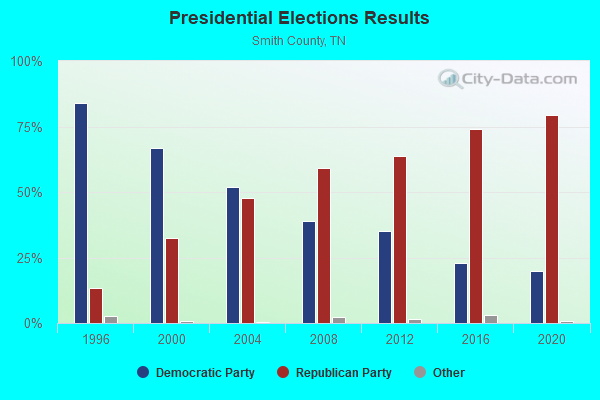
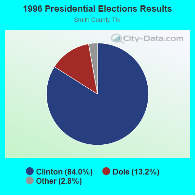
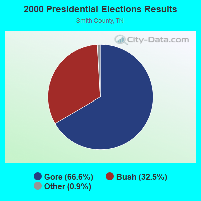
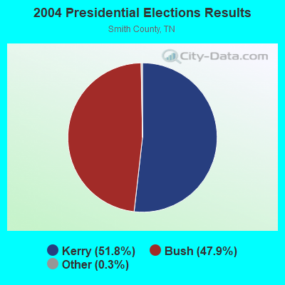
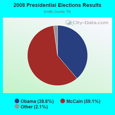
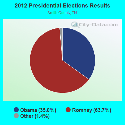
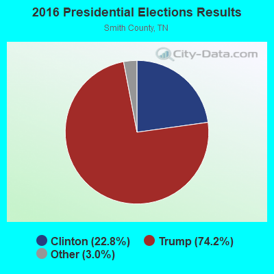
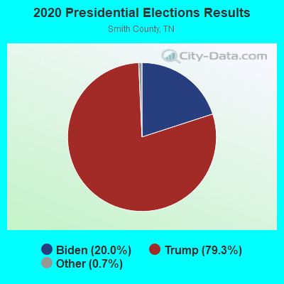
Graphs represent county-level data. Detailed 2008 Election Results
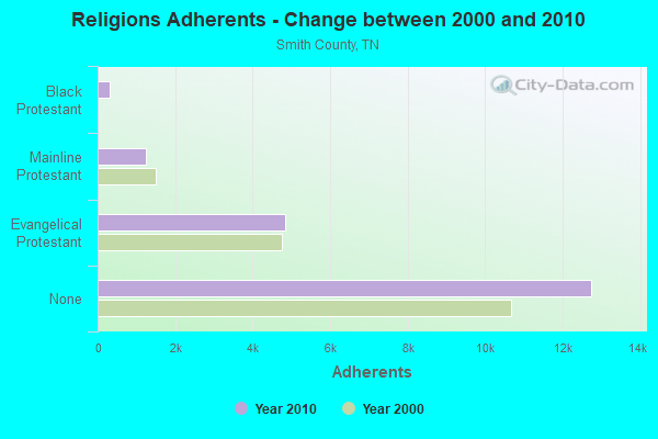
Religion statistics for Forks of the River, TN (based on Smith County data)
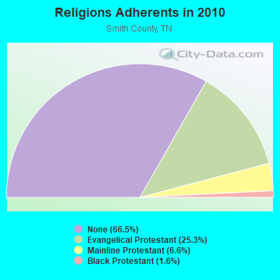
| Religion | Adherents | Congregations |
|---|---|---|
| Evangelical Protestant | 4,853 | 29 |
| Mainline Protestant | 1,256 | 14 |
| Black Protestant | 307 | 2 |
| Other | 1 | 1 |
| Catholic | - | - |
| None | 12,749 | - |
Food Environment Statistics:
| Smith County: | 3.19 / 10,000 pop. |
| State: | 1.99 / 10,000 pop. |
| Smith County: | 0.53 / 10,000 pop. |
| State: | 0.65 / 10,000 pop. |
| Smith County: | 6.92 / 10,000 pop. |
| State: | 5.16 / 10,000 pop. |
| Smith County: | 6.38 / 10,000 pop. |
| Tennessee: | 6.56 / 10,000 pop. |
| This county: | 11.5% |
| Tennessee: | 11.4% |
| Smith County: | 28.1% |
| Tennessee: | 30.2% |
| This county: | 14.0% |
| State: | 13.5% |
Strongest AM radio stations in Forks of the River:
- WRKM (1350 AM; 1 kW; CARTHAGE, TN; Owner: WOOD BROADCASTING, INC.)
- WSM (650 AM; 50 kW; NASHVILLE, TN; Owner: GAYLORD ENTERTAINMENT COMPANY)
- WAMB (1160 AM; 50 kW; DONELSON, TN; Owner: GREAT SOUTHERN BROADCASTING COMPANY, INC.)
- WLAC (1510 AM; 50 kW; NASHVILLE, TN; Owner: CAPSTAR TX LIMITED PARTNERSHIP)
- WKDA (1200 AM; 50 kW; NASHVILLE, TN; Owner: RADIO NASHVILLE, INC.)
- WNQM (1300 AM; 50 kW; NASHVILLE, TN; Owner: WNQM. INC.)
- WWAM (820 AM; daytime; 50 kW; JASPER, TN; Owner: SHELTON BROADCASTING SYSTEM)
- WFLI (1070 AM; 50 kW; LOOKOUT MOUNTAIN, TN; Owner: WFLI, INC.)
- WKVL (850 AM; daytime; 50 kW; KNOXVILLE, TN; Owner: HORNE RADIO, LLC)
- WPLN (1430 AM; 15 kW; MADISON, TN)
- WMGC (810 AM; 5 kW; MURFREESBORO, TN; Owner: RADIO 810 NASHVILLE, LIMITED)
- WHIN (1010 AM; 5 kW; GALLATIN, TN; Owner: WHIN, INC.)
- WATX (1590 AM; 2 kW; ALGOOD, TN; Owner: JWC BROADCASTING)
Strongest FM radio stations in Forks of the River:
- WUCZ (104.1 FM; CARTHAGE, TN; Owner: WOOD BROADCASTING, INC.)
- WGSQ (94.7 FM; COOKEVILLE, TN; Owner: CLEAR CHANNEL BROADCASTING LICENSES, INC.)
- WBXE (93.7 FM; BAXTER, TN; Owner: JWC BROADCASTING)
- WMOT (89.5 FM; MURFREESBORO, TN; Owner: MIDDLE TENNESSEE STATE UNIVERSITY)
- WWOG (90.9 FM; COOKEVILLE, TN; Owner: SOMERSET EDUCATIONAL BROADCASTING FOUNDATION)
- WGFX (104.5 FM; GALLATIN, TN; Owner: CITADEL BROADCASTING COMPANY)
- WGIC (98.5 FM; COOKEVILLE, TN; Owner: CLEAR CHANNEL BROADCASTING LICENSES, INC.)
- WLQK (95.9 FM; LIVINGSTON, TN; Owner: JWC BROADCASTING)
- WMAK (96.3 FM; MURFREESBORO, TN; Owner: SOUTH CENTRAL COMMUNICATIONS CORP.)
- WWTN (99.7 FM; MANCHESTER, TN; Owner: CUMULUS LICENSING CORP.)
- WLIV-FM (104.7 FM; MONTEREY, TN; Owner: WKXN INC)
- WKXD-FM (106.9 FM; MONTEREY, TN; Owner: JWC BROADCASTING)
- W206AJ (89.1 FM; COOKEVILLE, TN; Owner: WAY-FM MEDIA GROUP, INC.)
- WHRS (91.7 FM; COOKEVILLE, TN; Owner: NASHVILLE PUBLIC RADIO)
- WANT (98.9 FM; LEBANON, TN; Owner: BAY-POINTE BROADCASTING, INC.)
- WLCT (102.1 FM; LAFAYETTE, TN; Owner: LAFAYETTE BROADCASTING CO., INC.)
- WFMQ (91.5 FM; LEBANON, TN; Owner: CUMBERLAND UNIVERSITY)
TV broadcast stations around Forks of the River:
- WPGD (Channel 50; HENDERSONVILLE, TN; Owner: TRINITY BROADCASTING NETWORK)
- WCTE (Channel 22; COOKEVILLE, TN; Owner: UPPER CUMBERLAND BROADCAST COUNCIL)
- WHTN (Channel 39; MURFREESBORO, TN; Owner: CHRISTIAN TELEVISION NETWORK, INC.)

- 52.1%Electricity
- 38.7%Bottled, tank, or LP gas
- 7.7%Wood
- 1.5%Utility gas

- 48.1%Bottled, tank, or LP gas
- 27.9%Electricity
- 20.2%Wood
- 3.9%Fuel oil, kerosene, etc.
Forks of the River compared to Tennessee state average:
- Unemployed percentage significantly below state average.
- Black race population percentage significantly below state average.
- Hispanic race population percentage significantly below state average.
- Foreign-born population percentage significantly below state average.
- Renting percentage significantly below state average.
- Length of stay since moving in significantly above state average.
- Number of rooms per house significantly below state average.
- House age significantly below state average.
- Number of college students below state average.
- Percentage of population with a bachelor's degree or higher significantly below state average.