Hardin Valley, Tennessee
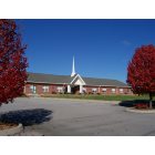
Hardin Valley: Hardin Valley Free Will Baptist Church
Hardin Valley: Hardin Valley Free Will Baptist Church
- add
your


Submit your own pictures of this place and show them to the world
- OSM Map
- General Map
- Google Map
- MSN Map

| Males: 8,044 | |
| Females: 8,223 |
| Median resident age: | 37.2 years |
| Tennessee median age: | 35.9 years |
Zip code: 37932
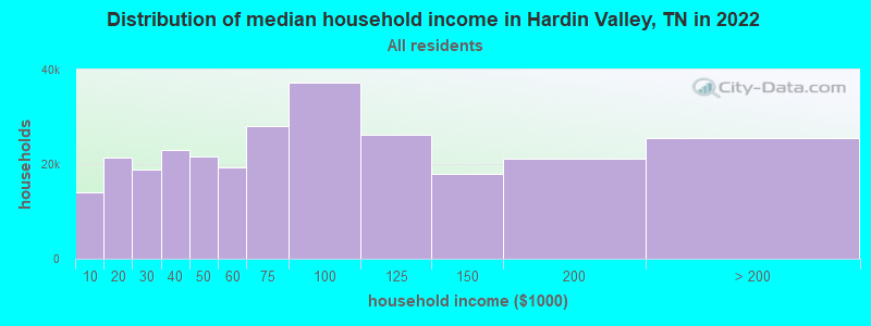
| Hardin Valley: | $95,332 |
| TN: | $65,254 |
Estimated per capita income in 2022: $45,948 (it was $24,930 in 2000)
Hardin Valley CCD income, earnings, and wages data
Estimated median house or condo value in 2022: $358,374 (it was $112,300 in 2000)
| Hardin Valley: | $358,374 |
| TN: | $284,800 |
Mean prices in 2022: all housing units: $359,911; detached houses: $378,570; townhouses or other attached units: $302,801; in 2-unit structures: $187,496; in 3-to-4-unit structures: $174,348; in 5-or-more-unit structures: $303,260; mobile homes: $93,622; occupied boats, rvs, vans, etc.: $148,834
Detailed information about poverty and poor residents in Hardin Valley, TN


- 13,77893.9%White alone
- 4262.9%Black alone
- 1511.0%Asian alone
- 1290.9%Two or more races
- 1350.9%Hispanic
- 390.3%American Indian alone
- 80.05%Other race alone
- 60.04%Native Hawaiian and Other
Pacific Islander alone
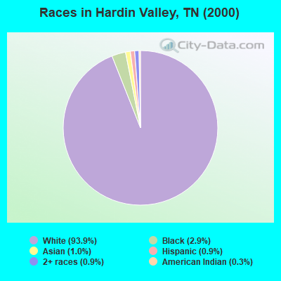
Races in Hardin Valley detailed stats: ancestries, foreign born residents, place of birth
 Recent articles from our blog. Our writers, many of them Ph.D. graduates or candidates, create easy-to-read articles on a wide variety of topics.

Current Local Time: EST time zone
Land area: 40.4 square miles.
Population density: 402 people per square mile (low).

| Hardin Valley CCD: | 0.7% ($822) |
| Tennessee: | 0.8% ($715) |
Nearest city with pop. 50,000+: Knoxville, TN  (13.3 miles , pop. 173,890).
Nearest city with pop. 200,000+: Nashville-Davidson, TN (145.6 miles , pop. 545,524).
Nearest city with pop. 1,000,000+: Chicago, IL (450.1 miles , pop. 2,896,016).
Nearest cities:
), ), ), )Latitude: 35.93 N, Longitude: 84.17 W
Area code commonly used in this area: 865

| Here: | 2.6% |
| Tennessee: | 3.0% |
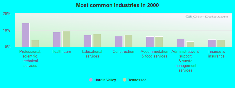
- Professional, scientific, technical services (14.4%)
- Health care (8.8%)
- Educational services (7.1%)
- Construction (6.3%)
- Accommodation & food services (6.2%)
- Administrative & support & waste management services (4.7%)
- Finance & insurance (4.4%)
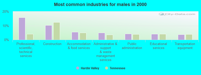
- Professional, scientific, technical services (15.7%)
- Construction (10.3%)
- Accommodation & food services (5.5%)
- Administrative & support & waste management services (4.9%)
- Public administration (4.3%)
- Educational services (4.1%)
- Transportation equipment (3.8%)
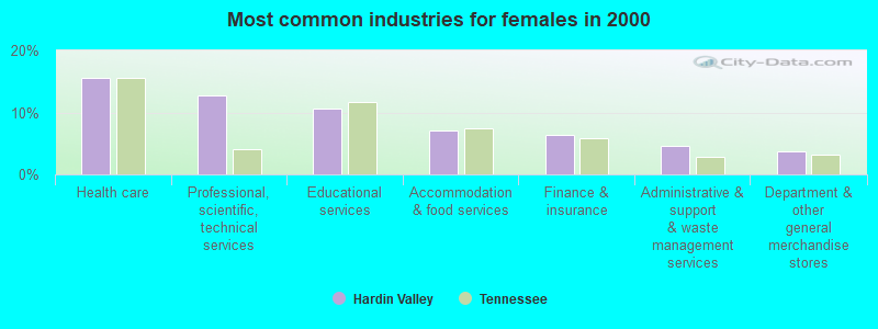
- Health care (15.6%)
- Professional, scientific, technical services (12.7%)
- Educational services (10.7%)
- Accommodation & food services (7.0%)
- Finance & insurance (6.4%)
- Administrative & support & waste management services (4.5%)
- Department & other general merchandise stores (3.8%)
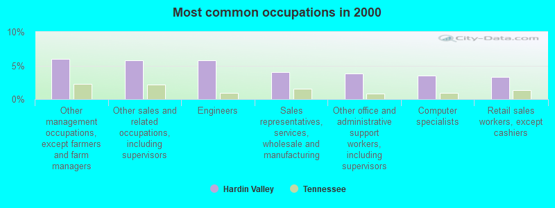
- Other management occupations, except farmers and farm managers (6.0%)
- Other sales and related occupations, including supervisors (5.8%)
- Engineers (5.8%)
- Sales representatives, services, wholesale and manufacturing (4.0%)
- Other office and administrative support workers, including supervisors (3.9%)
- Computer specialists (3.5%)
- Retail sales workers, except cashiers (3.3%)
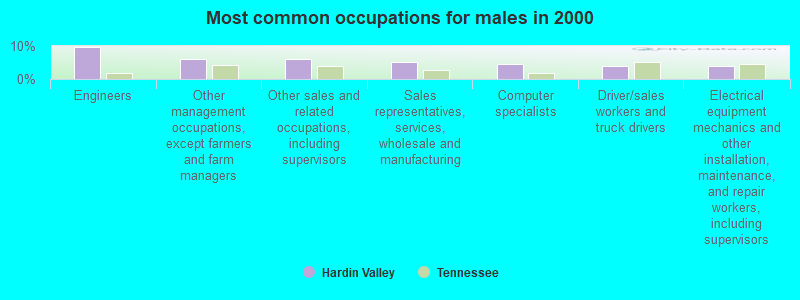
- Engineers (9.7%)
- Other management occupations, except farmers and farm managers (6.2%)
- Other sales and related occupations, including supervisors (6.0%)
- Sales representatives, services, wholesale and manufacturing (5.2%)
- Computer specialists (4.5%)
- Driver/sales workers and truck drivers (4.0%)
- Electrical equipment mechanics and other installation, maintenance, and repair workers, including supervisors (3.9%)
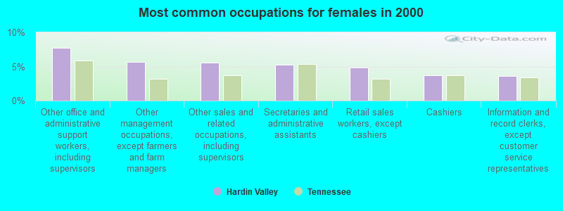
- Other office and administrative support workers, including supervisors (7.7%)
- Other management occupations, except farmers and farm managers (5.7%)
- Other sales and related occupations, including supervisors (5.6%)
- Secretaries and administrative assistants (5.3%)
- Retail sales workers, except cashiers (4.8%)
- Cashiers (3.7%)
- Information and record clerks, except customer service representatives (3.6%)
Average climate in Hardin Valley, Tennessee
Based on data reported by over 4,000 weather stations


(lower is better)
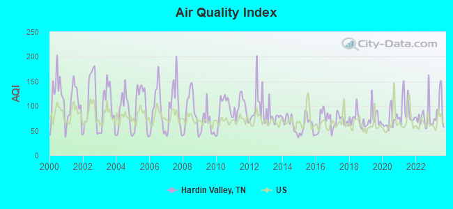
Air Quality Index (AQI) level in 2023 was 89.5. This is worse than average.
| City: | 89.5 |
| U.S.: | 72.6 |
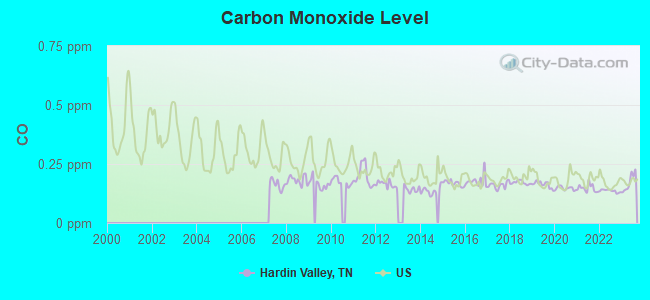
Carbon Monoxide (CO) [ppm] level in 2023 was 0.171. This is significantly better than average. Closest monitor was 13.6 miles away from the city center.
| City: | 0.171 |
| U.S.: | 0.251 |
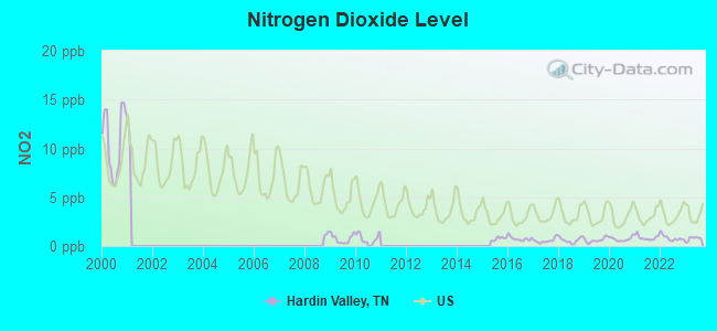
Nitrogen Dioxide (NO2) [ppb] level in 2023 was 0.751. This is significantly better than average. Closest monitor was 8.2 miles away from the city center.
| City: | 0.751 |
| U.S.: | 5.109 |
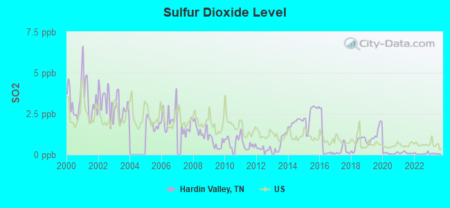
Sulfur Dioxide (SO2) [ppb] level in 2023 was 0.0574. This is significantly better than average. Closest monitor was 2.4 miles away from the city center.
| City: | 0.0574 |
| U.S.: | 1.5147 |
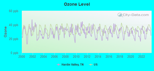
Ozone [ppb] level in 2023 was 32.5. This is about average. Closest monitor was 3.6 miles away from the city center.
| City: | 32.5 |
| U.S.: | 33.3 |
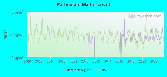
Particulate Matter (PM10) [µg/m3] level in 2023 was 18.9. This is about average. Closest monitor was 12.0 miles away from the city center.
| City: | 18.9 |
| U.S.: | 19.2 |
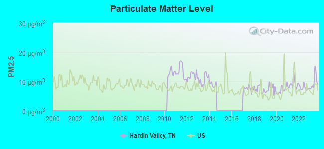
Particulate Matter (PM2.5) [µg/m3] level in 2023 was 9.83. This is worse than average. Closest monitor was 7.8 miles away from the city center.
| City: | 9.83 |
| U.S.: | 8.11 |
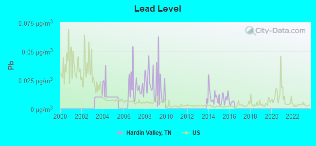
Lead (Pb) [µg/m3] level in 2015 was 0.00868. This is about average. Closest monitor was 7.3 miles away from the city center.
| City: | 0.00868 |
| U.S.: | 0.00931 |
Tornado activity:
Hardin Valley-area historical tornado activity is below Tennessee state average. It is 26% smaller than the overall U.S. average.
On 2/21/1993, a category F3 (max. wind speeds 158-206 mph) tornado 7.4 miles away from the Hardin Valley place center injured 3 people and caused between $500,000 and $5,000,000 in damages.
On 2/21/1993, a category F3 tornado 15.5 miles away from the place center killed one person and injured 55 people and caused between $5000 and $50,000 in damages.
Earthquake activity:
Hardin Valley-area historical earthquake activity is significantly above Tennessee state average. It is 86% greater than the overall U.S. average.On 11/30/1973 at 07:48:41, a magnitude 4.7 (4.7 MB, 4.6 ML, Class: Light, Intensity: IV - V) earthquake occurred 15.0 miles away from the city center
On 7/27/1980 at 18:52:21, a magnitude 5.2 (5.1 MB, 4.7 MS, 5.0 UK, 5.2 UK, Class: Moderate, Intensity: VI - VII) earthquake occurred 157.8 miles away from Hardin Valley center
On 4/29/2003 at 08:59:39, a magnitude 4.9 (4.4 MB, 4.6 MW, 4.9 LG) earthquake occurred 129.0 miles away from the city center
On 8/9/2020 at 12:07:37, a magnitude 5.1 (5.1 MW, Depth: 4.7 mi) earthquake occurred 176.0 miles away from the city center
On 12/12/2018 at 09:14:43, a magnitude 4.4 (4.4 MW, Depth: 4.9 mi) earthquake occurred 38.3 miles away from the city center
On 4/18/2008 at 09:36:59, a magnitude 5.4 (5.1 MB, 4.8 MS, 5.4 MW, 5.2 MW) earthquake occurred 268.7 miles away from Hardin Valley center
Magnitude types: regional Lg-wave magnitude (LG), body-wave magnitude (MB), local magnitude (ML), surface-wave magnitude (MS), moment magnitude (MW)
Natural disasters:
The number of natural disasters in Knox County (13) is near the US average (15).Major Disasters (Presidential) Declared: 8
Emergencies Declared: 2
Causes of natural disasters: Floods: 9, Storms: 7, Tornadoes: 6, Winds: 3, Winter Storms: 2, Heavy Rain: 1, Hurricane: 1, Landslide: 1, Mudslide: 1, Snowfall: 1, Other: 1 (Note: some incidents may be assigned to more than one category).
Hospitals and medical centers near Hardin Valley:
- FMC WEST KNOXVILLE (Dialysis Facility, about 3 miles away; KNOXVILLE, TN)
- EAST TN CHILDRENS HOSP HOME HEALTH (Home Health Center, about 4 miles away; KNOXVILLE, TN)
- BAPTIST HOSPITAL FOR WOMEN (Hospital, about 4 miles away; KNOXVILLE, TN)
- BAPTIST HOSPITAL WEST (Hospital, about 4 miles away; KNOXVILLE, TN)
- KNOXVILLE CENTRAL DIALYSIS (Dialysis Facility, about 5 miles away; KNOXVILLE, TN)
- SYMPHONY HOME CARE SVS KNOXVILLE PEC (Home Health Center, about 5 miles away; KNOXVILLE, TN)
- FARRAGUT HEALTH CARE CENTER LTD (Nursing Home, about 6 miles away; KNOXVILLE, TN)
Colleges/universities with over 2000 students nearest to Hardin Valley:
- Pellissippi State Community College (about 2 miles; Knoxville, TN; Full-time enrollment: 7,271)
- The University of Tennessee-Knoxville (about 14 miles; Knoxville, TN; FT enrollment: 25,483)
- Roane State Community College (about 26 miles; Harriman, TN; FT enrollment: 4,302)
- Lincoln Memorial University (about 54 miles; Harrogate, TN; FT enrollment: 3,706)
- Walters State Community College (about 55 miles; Morristown, TN; FT enrollment: 4,359)
- University of the Cumberlands (about 56 miles; Williamsburg, KY; FT enrollment: 3,585)
- Cleveland State Community College (about 65 miles; Cleveland, TN; FT enrollment: 2,500)
Points of interest:
Notable locations in Hardin Valley: Fiesta Farm (A), Melton Hill Community Center (B), Karns Volunteer Fire Department Station 3 (C), Karns Volunteer Fire Department Station 2 (D), Rural / Metro Ambulance Knox County (E). Display/hide their locations on the map
Churches in Hardin Valley include: Fairview Church (A), Stoney Point Church (B), Unity Church (C), Providence Church (D), Hudson Grove Church (E), Hines Valley Church (F), Smith Grove Church (G), Solway Church (H), Byrds Chapel Wesleyan Methodist Church (I). Display/hide their locations on the map
Cemeteries: Yarnell Cemetery (1), Lebanon Cemetery (2), Blackoak Cemetery (3), Cobb Cemetery (4), Pet Memorial Cemetery (5), Estes Cemetery (6), Hickory Creek Cemetery (7). Display/hide their locations on the map
Streams, rivers, and creeks: Hickory Creek (A), Grable Branch (B), Hewitt Branch (C), Plumb Creek (D), Beaver Creek (E), Conner Creek (F), Meadow Creek (G). Display/hide their locations on the map
Parks in Hardin Valley include: Guinn Road Park (1), Hickory Creek Park (2), Melton Hill Park (3). Display/hide their locations on the map
| This place: | 2.6 people |
| Tennessee: | 2.5 people |
| This place: | 68.0% |
| Whole state: | 69.8% |
| This place: | 3.5% |
| Whole state: | 4.2% |
Likely homosexual households (counted as self-reported same-sex unmarried-partner households)
- Lesbian couples: 0.3% of all households
- Gay men: 0.2% of all households
| This place: | 5.0% |
| Whole state: | 13.5% |
| This place: | 2.4% |
| Whole state: | 5.8% |
12 people in other noninstitutional group quarters in 2000
For population 15 years and over in Hardin Valley:
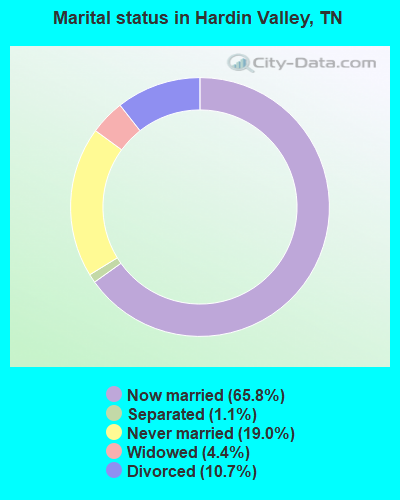
- Never married: 19.0%
- Now married: 65.8%
- Separated: 1.1%
- Widowed: 4.4%
- Divorced: 10.7%
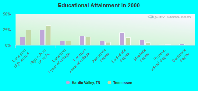
For population 25 years and over in Hardin Valley:
- High school or higher: 87.0%
- Bachelor's degree or higher: 32.7%
- Graduate or professional degree: 12.2%
- Unemployed: 2.7%
- Mean travel time to work (commute): 21.9 minutes
| Here: | 11.6 |
| Tennessee average: | 13.3 |
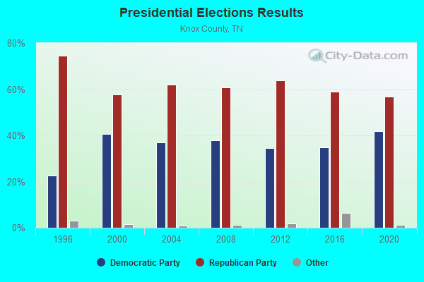
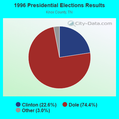
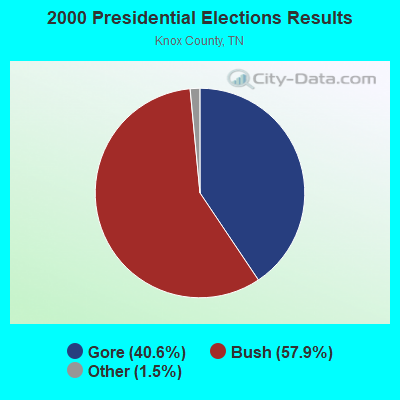
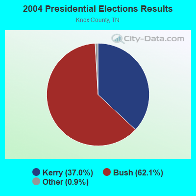
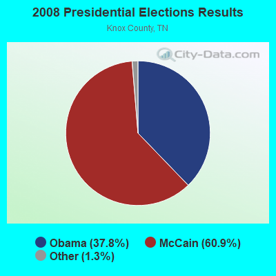
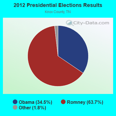
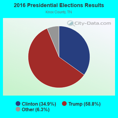
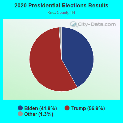
Graphs represent county-level data. Detailed 2008 Election Results
Religion statistics for Hardin Valley, TN (based on Knox County data)
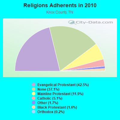
| Religion | Adherents | Congregations |
|---|---|---|
| Evangelical Protestant | 183,754 | 365 |
| Mainline Protestant | 51,345 | 116 |
| Catholic | 21,988 | 7 |
| Other | 7,178 | 34 |
| Black Protestant | 6,897 | 29 |
| Orthodox | 818 | 2 |
| None | 160,246 | - |
Food Environment Statistics:
| This county: | 1.75 / 10,000 pop. |
| Tennessee: | 1.99 / 10,000 pop. |
| This county: | 0.12 / 10,000 pop. |
| Tennessee: | 0.17 / 10,000 pop. |
| Knox County: | 1.37 / 10,000 pop. |
| Tennessee: | 0.65 / 10,000 pop. |
| Here: | 3.82 / 10,000 pop. |
| State: | 5.16 / 10,000 pop. |
| Knox County: | 7.39 / 10,000 pop. |
| State: | 6.56 / 10,000 pop. |
| This county: | 12.0% |
| State: | 11.4% |
| This county: | 27.5% |
| Tennessee: | 30.2% |
| Knox County: | 13.7% |
| State: | 13.5% |
8.03% of this county's 2021 resident taxpayers lived in other counties in 2020 ($70,106 average adjusted gross income)
| Here: | 8.03% |
| Tennessee average: | 8.49% |
0.02% of residents moved from foreign countries ($141 average AGI)
Knox County: 0.02% Tennessee average: 0.02%
Top counties from which taxpayers relocated into this county between 2020 and 2021:
| from Blount County, TN | |
| from Anderson County, TN | |
| from Sevier County, TN |
Strongest AM radio stations in Hardin Valley:
- WKVL (850 AM; daytime; 50 kW; KNOXVILLE, TN; Owner: HORNE RADIO, LLC)
- WMTY (670 AM; daytime; 2 kW; FARRAGUT, TN; Owner: HORNE RADIO, LLC)
- WQBB (1040 AM; daytime; 10 kW; POWELL, TN; Owner: JOURNAL BROADCAST CORPORATION)
- WATO (1290 AM; 5 kW; OAK RIDGE, TN)
- WNOX (990 AM; 10 kW; KNOXVILLE, TN)
- WVLZ (1180 AM; daytime; 10 kW; KNOXVILLE, TN; Owner: KIRKLAND WIRELESS BROADCASTERS, INC.)
- WRJZ (620 AM; 5 kW; KNOXVILLE, TN; Owner: TENNESSEE MEDIA ASSOCIATES, INC)
- WKXV (900 AM; 1 kW; KNOXVILLE, TN; Owner: RA-TEL BROADCASTING COMPANY, INC.)
- WMEN (760 AM; daytime; 2 kW; KNOXVILLE, TN; Owner: THOMAS MOFFIT JR.)
- WLIL (730 AM; 1 kW; LENOIR CITY, TN; Owner: BP BROADCASTERS, LLC)
- WECO (940 AM; 5 kW; WARTBURG, TN; Owner: MORGAN COUNTY B/CASTING CO.)
- WWAM (820 AM; daytime; 50 kW; JASPER, TN; Owner: SHELTON BROADCASTING SYSTEM)
- WKGN (1340 AM; 1 kW; KNOXVILLE, TN; Owner: TRIPLE S ENTERPRISES, INC.)
Strongest FM radio stations in Hardin Valley:
- WNFZ (94.3 FM; OAK RIDGE, TN; Owner: JOHN W. PIRKLE)
- WOKI-FM (100.3 FM; OAK RIDGE, TN; Owner: OAK RIDGE FM, INC.)
- WMYU (93.1 FM; KARNS, TN; Owner: JOURNAL BROADCAST CORPORATION)
- WUOT (91.9 FM; KNOXVILLE, TN; Owner: UNIVERSITY OF TENNESSEE)
- WDVX (89.9 FM; CLINTON, TN; Owner: CUMBERLAND COMMUNITIES COMMUNI CORP.)
- WJXB-FM (97.5 FM; KNOXVILLE, TN; Owner: SOUTH CENTRAL COMMUNICATIONS CORP.)
- WYLV (89.1 FM; ALCOA, TN; Owner: FOOTHILLS BROADCASTING, INC.)
- WYIL-FM (98.7 FM; OLIVER SPRINGS, TN; Owner: CITADEL BROADCASTING COMPANY)
- WIVK-FM (107.7 FM; KNOXVILLE, TN; Owner: CITADEL BROADCASTING COMPANY)
- WYFC (95.3 FM; CLINTON, TN; Owner: BIBLE BROADCASTING NETWORK, INC.)
- WWST (102.1 FM; SEVIERVILLE, TN; Owner: JOURNAL BROADCAST CORPORATION)
- WKZX-FM (93.5 FM; LENOIR CITY, TN; Owner: BP BROADCASTERS, LLC)
- WIMZ-FM (103.5 FM; KNOXVILLE, TN; Owner: SOUTH CENTRAL COMM., CORP.)
- WKVL-FM (105.3 FM; LOUDON, TN; Owner: HORNE RADIO, LLC)
- WTXM-FM (95.7 FM; MARYVILLE, TN; Owner: SOUTH CENTRAL COMMUNICATIONS CORP.)
- WKHT (104.5 FM; KNOXVILLE, TN; Owner: JOURNAL BROADCAST CORPORATION)
- WRMX-FM (106.7 FM; NORRIS, TN; Owner: SOUTH CENTRAL COMMUNICATIONS CORPORATION)
- WNOX-FM (99.1 FM; LOUDON, TN; Owner: CITADEL BROADCASTING COMPANY)
- WWSR (105.7 FM; ROCKWOOD, TN; Owner: SOUTHERN MEDIA GROUP, INC.)
- WCVP-FM (95.9 FM; ROBBINSVILLE, NC; Owner: CHEROKEE BROADCASTING COMPANY, INC.)
TV broadcast stations around Hardin Valley:
- W46DC (Channel 46; KNOXVILLE, TN; Owner: TRINITY BROADCASTING NETWORK)
- WDTT-LP (Channel 38; LENOIR CITY, TN; Owner: WORD OF GOD FELLOWSHIP, INC.)
- WVLT-TV (Channel 8; KNOXVILLE, TN; Owner: WVLT LICENSEE CORP.)
- WKOP-TV (Channel 15; KNOXVILLE, TN; Owner: EAST TENNESSEE PUBLIC COMMUNICATIONS CORP.)
- WBIR-TV (Channel 10; KNOXVILLE, TN; Owner: GANNETT PACIFIC CORPORATION)
- WATE-TV (Channel 6; KNOXVILLE, TN; Owner: WATE, G.P.)
- WTNZ (Channel 43; KNOXVILLE, TN; Owner: RAYCOM AMERICA, INC.)
- WEEE-LP (Channel 32; KNOXVILLE, TN; Owner: TIGER EYE BROADCASTING CORPORATION)
- WEZK-LP (Channel 28; KNOXVILLE, TN; Owner: SOUTH CENTRAL COMMUNICATIONS CORP.)
- W50CG (Channel 50; KNOXVILLE, TN; Owner: THREE ANGELS BROADCASTING NETWORK, INC.)
- W56CM (Channel 56; KNOXVILLE, TN; Owner: VENTANA TELEVISION, INC.)
- W50AB (Channel 50; HIAWASSEE, GA; Owner: GEORGIA PUBLIC TELECOMMUNICATIONS COMMISSION)
- WFEM-LP (Channel 12; HEISKELL, ETC., TN; Owner: H. EARL MARLAR)
- WKXE-LP (Channel 4; KNOXVILLE, TN; Owner: TIGER EYE BROADCASTING CORPORATION)
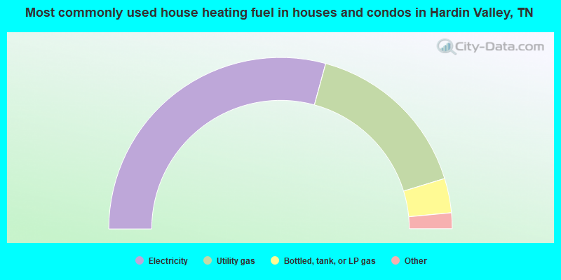
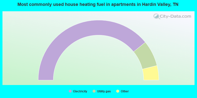
- 58.5%Electricity
- 32.0%Utility gas
- 6.5%Bottled, tank, or LP gas
- 1.6%Wood
- 1.2%Fuel oil, kerosene, etc.
- 0.2%No fuel used
- 78.3%Electricity
- 13.9%Utility gas
- 4.0%Bottled, tank, or LP gas
- 2.8%Fuel oil, kerosene, etc.
- 1.1%Wood
Hardin Valley compared to Tennessee state average:
- Unemployed percentage significantly below state average.
- Black race population percentage significantly below state average.
- Hispanic race population percentage significantly below state average.
- Foreign-born population percentage significantly below state average.
- Renting percentage significantly below state average.
- Length of stay since moving in significantly above state average.
- Number of rooms per house significantly below state average.
- House age significantly below state average.
- Percentage of population with a bachelor's degree or higher above state average.
Hardin Valley on our top lists:
- #10 on the list of "Top 101 cities with largest percentage of males in occupations: engineers (population 5,000+)"
- #24 on the list of "Top 101 cities with largest percentage of females in industries: machinery, equipment, and supplies merchant wholesalers (population 5,000+)"
- #53 on the list of "Top 101 cities with largest percentage of males in occupations: occupational and physical therapist assistants and aides (population 5,000+)"
- #62 on the list of "Top 101 cities with largest percentage of males in occupations: communications equipment operators (population 5,000+)"
- #73 on the list of "Top 101 cities with largest percentage of females in occupations: librarians, curators, and archivists (population 5,000+)"
- #74 on the list of "Top 101 cities with largest percentage of males in industries: furniture and home furnishings, and household appliance stores (population 5,000+)"
- #75 on the list of "Top 101 cities with largest percentage of females in occupations: occupational and physical therapist assistants and aides (population 5,000+)"
- #77 on the list of "Top 101 cities with largest percentage of males in occupations: plant and system operators (population 5,000+)"
- #79 on the list of "Top 101 cities with largest percentage of females in industries: sewing, needlework, and piece goods stores (population 5,000+)"
- #94 on the list of "Top 101 cities with largest percentage of males in industries: office supplies and stationery stores (population 5,000+)"
- #100 on the list of "Top 101 cities with largest percentage of females in industries: drugs, sundries, and chemical and allied products merchant wholesalers (population 5,000+)"
- #3 on the list of "Top 101 counties with the lowest percentage of residents that drank alcohol in the past 30 days"
- #30 on the list of "Top 101 counties with the most Evangelical Protestant adherents"
- #49 on the list of "Top 101 counties with the worst general health status score of residents (1-5), 3 years of data"
- #51 on the list of "Top 101 counties with the most Evangelical Protestant congregations"
- #66 on the list of "Top 101 counties with the highest percentage of residents that keep firearms around their homes"